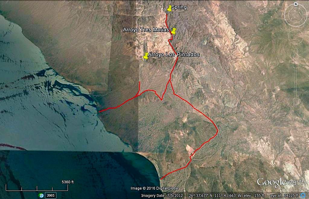
In 2016, just after a little hurricane passed by we went up the peninsula and while three of us were going around that mud flat, one had to gonzo
across it, only to bog down... Just a pull got him out. I logged both the Pintados junction (its by three cardón cacti known as the 3 Musketeers) and
the Rancho San Ignacio junction as we drove north as far as we could. The next day, heading back south, we turned east at the 3 Musketeers but with
the recent flash flooding in the area, no tracks to follow but I had a feeling on where to go... but before reaching the canyon another in our group
of 4 vehicles saw a diffinate road and I turned back for the good news... only that road went up the next canyon Tres Marias. It was beautiful in
there but it was not Los Pintados!
Road east from Hwy. 1 at Km. 74:
A cattle ranch is passed at 0.4 mile.
At Mile 1.0 we join the old, pre-1970 main Baja road, that comes in from Km. 76 off Mex. 1.
At Mile 3.7 the main route of travel forks left for the bay.
At Mile 4.7 the road closest to the bay from the trailer park comes in from the left.
At Mile 5.6 fork to the left heading north.
At Mile 6.6 the road is next to the bay and going northbound.
At Mile 8.2 a road we used on the return meets the coast road.
At Mile 9.9 (just north of three cardón cactus growing side-by-side (and called The Three Musketeers) is the wash/ route to Los Pintados rock art.
Around Mile 13, the road goes inland as the coastline curves off to the west.
Mile 15 come close to the bay again briefly, then head towards the mountain.
Mile 16.8, curve left and head back downhill towards the bay.
Mile 19.4, reach a salt flat-like area near Punta Amolares. We camped near here about midnight
Mile 25 End of the road for us, a "grand canyon" gully stops us about 11pm+
Honored and Elited to have this input - David and the Buddha - modern day Indiana Jones'. Maybe I can repay with a report of my own one day. This is
wayyyy off road territory. If my trip goes I could see spending a couple of days and camp near one of these washes and explore higher up.
Just for my own curiosity:
is there any wild life/reptiles in this area?
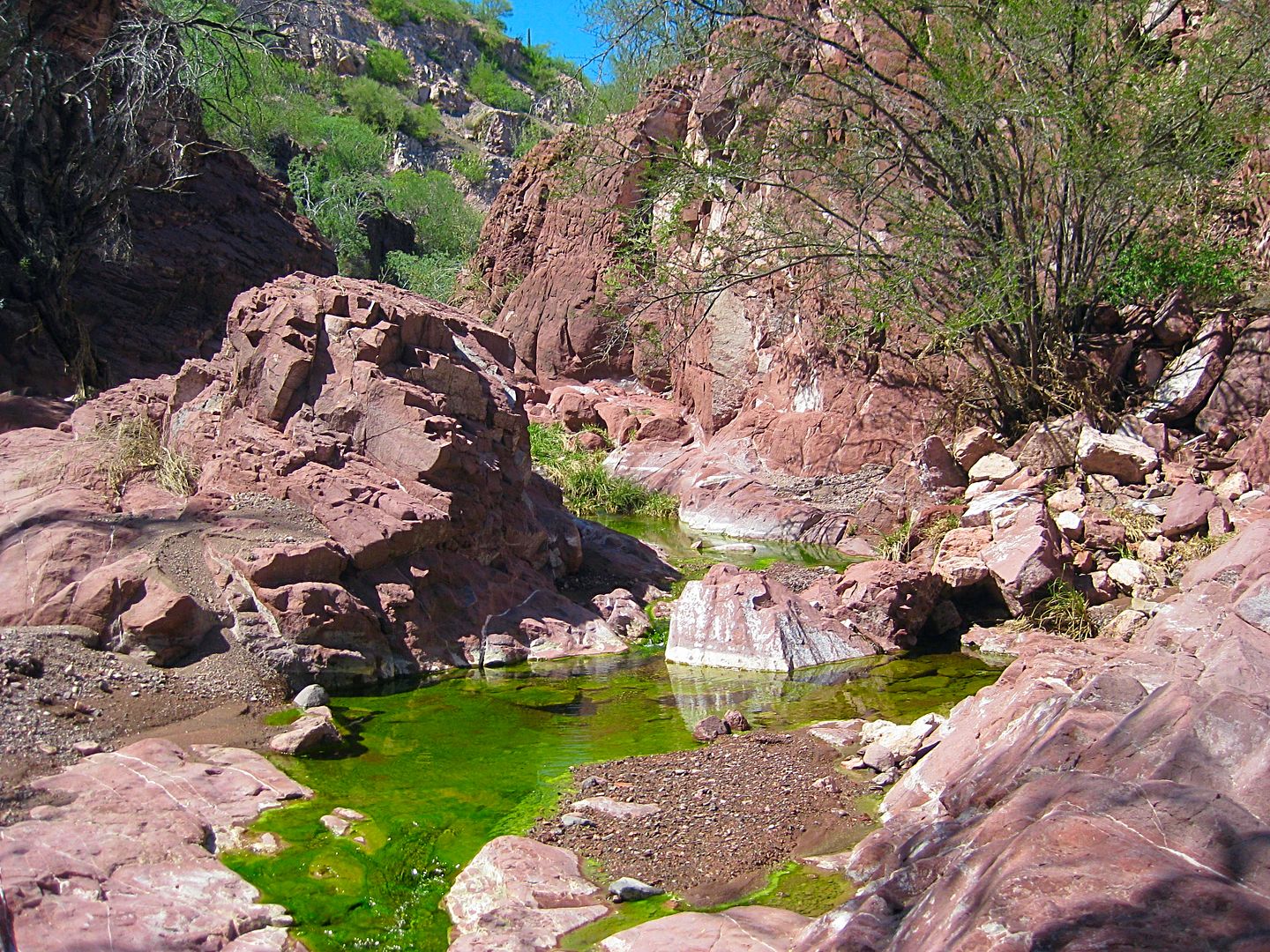
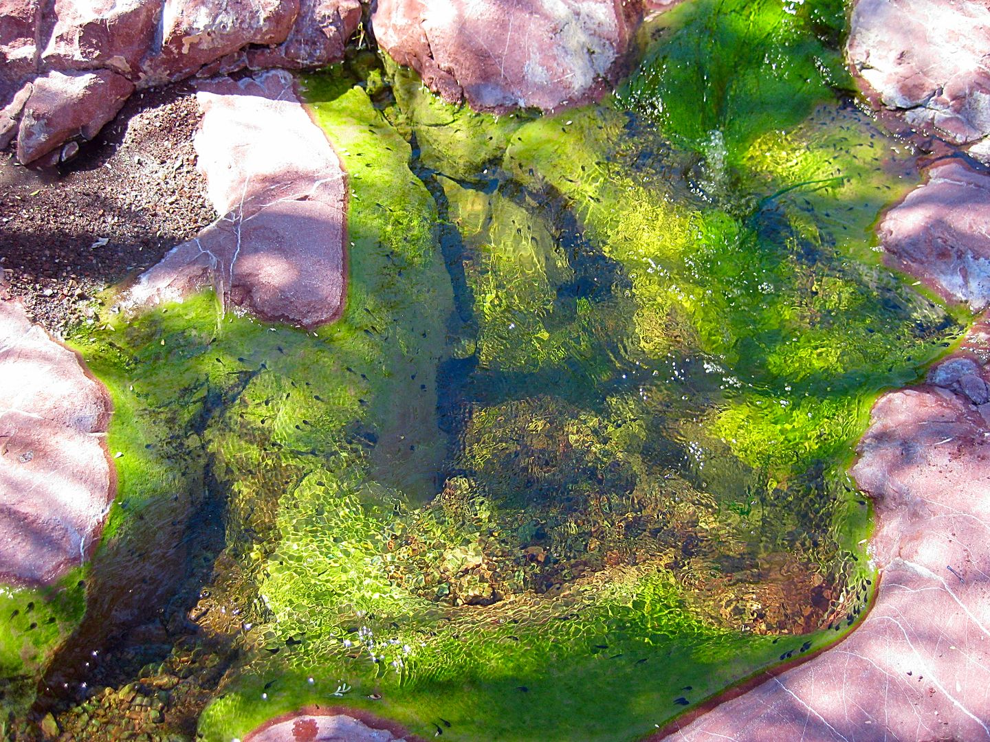
missed? photos of the spring mentioned - are talking just a small pool or hot spring / drinking water?
what is the ownership status of the peninsula? Is this all "public" property?
This ain't no party, this ain't no disco, this ain't no foolin' aroundLife During Wartime
- Talking Heads '79
Wildlife, yes. Reptiles, definitely. Hot springs, nope. Drinkable, definitely NOT.
Ownership? Probably, but not posted, at least used to wasn't. And you're right about the wayyyy off road territory; take extra stuff, and water.
If you wanna do the whole peninsula remember the road is very slow going the whole way... 4x4 advised. You're a long way from nowhere out there.
More than one rig, I used walkie-talkies.
I don't have a BUCKET LIST, but I do have a F***- IT LIST a mile long!
The north end of the peninsula has cell and Internet from the Mulegé cell tower. We always recommend you have a satellite communication device such
as an inReach or SpotX or a sat phone.
Forgot to ask , DK , in the video link above @ 2:35 first I thought busted rad with that lime green water. What was that? Mining chemical runoff?
My adventure will be 2 wheels instead of 4 so less worry about mechanical and terrain mucky mucks. Just learned about the inReach unit, planned on
some extra safety back up. Can imagine this was more typical of the mainland from the the 60/70's and your adventure into territory still unchanged
from Gardners day.
History and adventure...and no other humans. Like it.
Another 25+ years before an OXXO sets up here?
This ain't no party, this ain't no disco, this ain't no foolin' aroundLife During Wartime
- Talking Heads '79
Forgot to ask , DK , in the video link above @ 2:35 first I thought busted rad with that lime green water. What was that? Mining chemical runoff?
Oh heavens no, that is a natural stream and the green is the algae growing on the bottom. We hiked up to where the water came seeping out of the
boulders... so so cool! I photographed it.. in my trip report: The Baja Extreme 2016. http://forums.bajanomad.com/viewthread.php?tid=84056
"If it were lush and rich, one could understand the pull, but it is fierce and hostile and sullen.
The stone mountains pile up to the sky and there is little fresh water. But we know we must go back
if we live, and we don't know why." - Steinbeck, Log from the Sea of Cortez
"People don't care how much you know, until they know how much you care." - Theodore Roosevelt
"You can easily judge the character of others by how they treat those who they think can do nothing for them or to them." - Malcolm Forbes
"Let others lead small lives, but not you. Let others argue over small things, but not you. Let others
cry over small hurts, but not you. Let others leave their future in someone else's hands, but not you." - Jim Rohn
"The best way to get the right answer on the internet is not to ask a question; it's to post the wrong answer." - Cunningham's Law
Thankyou to Baja Bound
Mexico InsuranceServices for your long-term support of the BajaNomad.com Forums site.
Emergency Baja Contacts Include:
Desert Hawks;
El Rosario-based ambulance transport; Emergency #: (616) 103-0262