| Pages:
1
2 |
mtgoat666
Select Nomad

Posts: 17338
Registered: 9-16-2006
Location: San Diego
Member Is Offline
Mood: Hot n spicy
|
|
Quote: Originally posted by Ron_Perry  | Lots of good information here. I knew of "sag" for 45 years but didn't know it was an acronym...my belief was like mtgoat666. Also I didn't think
about mt.bikes...will try for the Jerry Schaad map. One mistake mtgoat666 I think, the climb from sea level to the top must be "total elevation" ,
around 10,000ft or more. Unless I misunderstood you.
I had no plans to try this without help....or without a sag. Will keep selling the idea to friends. Thank you again for the knowledge, Ron
|
Look for road profiles on strava, there are some posted. There are some long/steep grades just getting from hwy 1 to Meling, but longest climbs are
from meling to the edge of the plateau.
Woke!
“...ask not what your country can do for you – ask what you can do for your country.” “My fellow citizens of the world: ask not what America
will do for you, but what together we can do for the freedom of man.”
Prefered gender pronoun: the royal we
|
|
|
Maderita
Senior Nomad
Posts: 634
Registered: 12-14-2008
Location: San Diego
Member Is Offline
|
|
Rancho Meling 2,100' elevation.
|
|
|
caj13
Senior Nomad
Posts: 998
Registered: 8-1-2017
Member Is Offline
|
|
Ron,
I doubt i could make that climb anymore. back when i was young, we rode from fresno to Yosemite (including Glacier point just for fun) over 3
days. 150 miles, 7200 ft total gain, but lots of ups and downs making it alot more climbing) but no way i could do that now. I would ride whatever
i could with you, and can have it Sagged" if you chose to go after the sea otter classic. So if you run out of options, and need support, I can
help with that - assuming the vaccine program here in the USA gets off its ass and starts inoculating people at an acceptable rate.
|
|
|
David K
Honored Nomad
Posts: 64490
Registered: 8-30-2002
Location: San Diego County
Member Is Offline
Mood: Have Baja Fever
|
|
This is in my article, link posted above... elevations from GPS
ROAD LOG: Distance in miles (and kilometers)
0.0 Highway 1 at Km. 140.5, elevation 130'. The well-signed junction is 87 miles south of Ensenada.
4.2 (Km. 7) Narrow bridge
5.6 (Km. 9.5) San Telmo (now a ghost town) was an important visita old Mission Santo Domingo and a farming supply center until recent years when many
have moved down to Highway 1 for more opportunity.
11.3 (Km. 18+) Hacienda Sinaloa a town of farm workers with one small store.
17.0 (Km. 27.5) Road right goes to the old Valladares gold mines (18 miles) and El Potrero (27 miles).
17.6 (Km. 28.5) Signed road left to Ranchos (Las Choyas, Cortez, El Papalote). Road begins a steep climb.
22.0 (Km.35+) 1,000' elevation.
24.0 (Km. 38.5) 2,000' elevation.
30.3 (Km. 49) Road north to El Coyote guest ranch, 4.9 miles (rooms, camping, meals).
30.6 (Km. 49.5) Road to right to Meling Ranch, a guest ranch with a long history. Rooms, meals, camping, airstrip.
34.0 (Km. 55) 3,000' elevation.
39.0 (Km. 63) 4,000' elevation.
39.3 (Km. 63.5+) Road south to El Potrero.
40.6 (Km. 66) Socorro mine site. Not much left from the 1894-1910 when the Johnson family worked the placer goldfield.
41.6 (Km. 67+) Road left, signed to La Joya. Badly eroded from last winter's rains, this ranch and the former Dark Skies Inn (Rancho La Concepción)
was once reached this way, but today may be impassable.
43.4 (Km. 70) 5,000' elevation.
45.0 (Km. 72.5) 6,000' elevation.
45.2 (Km. 73) Fire break road to the right (yellow gate).
45.8 (Km. 73.5+) Road right 0.3 mi. to the former Los Manzanos RV Park/Campground. Abandoned.
46.3 (Km.74.5+) La Cienega de Soto, rental cabin.
48.1 (Km. 77.5) Former park entrance payment gate, ex-ranger station (6,800').
48.6 (Km. 78+) 7,000' elevation.
51.0 (Km. 82+) 8,000' elevation.
51.7 (Km. 83.5) Park Entrance Payment Ranger Station 'La Corona'. Elevation: 8,259'.
52.0 (Km. 84) Campo Cacomixtle, El Condor, Cimarron, and more, on both sides of the highway.
53.5 (Km. 86.5) Capilla San Pedro. A small chapel on a hilltop.
56.3 (Km. 91) Road south for La Tasajera (10 km.). Locked gate at Mile 1.9.
56.8 (Km. 91.5) Museum (closed).
57.8 (Km. 93+) The Aguaje del Burro road to the right goes 2.0 miles to a covered spring. This was an old cattle camp.
58.2 (Km. 93.5+) Mirador El Altar road right (elev. 8,000'). It is 0.3 mi. to the El Mirador trail. A right fork just off the highway goes 2.2 miles
to a pretty area.
58.9 (Km. 94.5+) Pass a military camp and a side road left to the Venado Blanco trail.
60.3 (Km. 97.5) Parking area (left) and gate restricting access to the observatories. 8,705'. A phone box on the left to request passage. It is 3
kilometers and over 500' higher to the end of the road at Mexico's largest telescope.
61.2 (Km. 99) 9,000' elevation.
62.1 (Km. 100+) Elev. 9,280'. The highest point reached by automobile in Baja California. The national observatory.
|
|
|
Maderita
Senior Nomad
Posts: 634
Registered: 12-14-2008
Location: San Diego
Member Is Offline
|
|
| Quote: Originally posted by David K |
62.1 (Km. 100+) Elev. 9,280'. The highest point reached by automobile in Baja California. The national observatory. |
This presents an interesting topographical question about the highest point reached by automobile  Not trying to be picky with the road log. Somewhat off-topic for those few of us who geek out on Baja trivia. Not trying to be picky with the road log. Somewhat off-topic for those few of us who geek out on Baja trivia.
According to Google Earth, 9,280' would be sitting on the roof of your automobile which is parked on the main observatory dome.
Google Earth shows the parking area (end of the pavement) below as 9,206'.
There is a small rise before entering the parking area. Google Earth shows 9,215', which may take the win.
There are some dirt roads which lead to other, smaller, observatories, but apparently none exceeding 9,140' in elevation.
|
|
|
David K
Honored Nomad
Posts: 64490
Registered: 8-30-2002
Location: San Diego County
Member Is Offline
Mood: Have Baja Fever
|
|
| Quote: Originally posted by Maderita | | Quote: Originally posted by David K |
62.1 (Km. 100+) Elev. 9,280'. The highest point reached by automobile in Baja California. The national observatory. |
This presents an interesting topographical question about the highest point reached by automobile Not trying to be picky with the road log. Somewhat off-topic for those few of us who geek out on Baja trivia.
According to Google Earth, 9,280' would be sitting on the roof of your automobile which is parked on the main observatory dome.
Google Earth shows the parking area (end of the pavement) below as 9,206'.
There is a small rise before entering the parking area. Google Earth shows 9,215', which may take the win.
There are some dirt roads which lead to other, smaller, observatories, but apparently none exceeding 9,140' in elevation. |
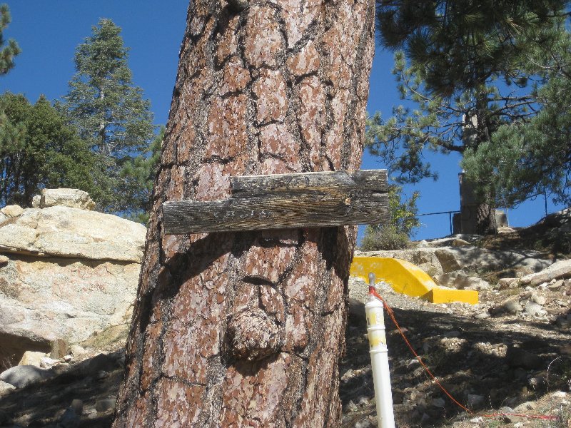
The elevation was posted when I was there in 1978. This sign was still there in 2017, but so badly worn and weathered the man in charge did not know
what it was.

|
|
|
PaulW
Ultra Nomad
Posts: 3009
Registered: 5-21-2013
Member Is Offline
|
|
Elevation and kilometer numbers are questioned.
Looking at Google it shows the telescope the top of the observatory is close to 9280'. The road gate is close to 9100'. I guess a bike rider could go
around the gate and pedal to the parking lot at ~9200'?
Sorry my GPS track is long gone so I cannot give real road distances or elevations, however distance of 100 Km is surely good enough for a bike rider?
|
|
|
David K
Honored Nomad
Posts: 64490
Registered: 8-30-2002
Location: San Diego County
Member Is Offline
Mood: Have Baja Fever
|
|
The road has (had) kilometer posts the whole 100 kms.
The new map book will also have dots at every kilometer with the number shown every 5 kms. on all the highways in Baja.
The every 1000 ft. elevation figures are from my Garmin inReach GPS. The final one at the end of the road is from the sign.
|
|
|
Maderita
Senior Nomad
Posts: 634
Registered: 12-14-2008
Location: San Diego
Member Is Offline
|
|
lencho,
Last weekend I took some GPS readings with a Garmin inReach. On top of one boulder, I noted an elevation of 5,184'. Just now compared it with Google
Earth which read 5,178' at that exact location. The discrepancy is only 6'. The terrain was strewn with boulders up to 30' high. Moving the cursor
around on the GE map doesn't show those variations. Perhaps GE does some averaging of elevations over rough terrain.
Here's what Garmin has to say:
https://support.garmin.com/en-US/?faq=QPc5x3ZFUv1QyoxITW2vZ6
"Understanding the Accuracy of the GPS Elevation Reading
GPS heights are based on an ellipsoid (a mathematical representation of the earth's shape), while USGS map elevations are based on a vertical datum
tied to the geoid (or what is commonly called mean sea level). Basically, these are two different systems, although they have a relationship that has
been modeled.
The main source of error has to do with the arrangement of the satellite configurations during fixed determinations. The earth blocks out satellites
needed to get a good quality vertical measurement. Once the vertical datum is taken into account, the accuracy permitted by geometry considerations
remains less than that of horizontal positions. It is not uncommon for satellite heights to be off from map elevations by +/- 400 ft. Use these values
with caution when navigating."
|
|
|
mtgoat666
Select Nomad
Posts: 17338
Registered: 9-16-2006
Location: San Diego
Member Is Offline
Mood: Hot n spicy
|
|
google earth and commercial grade GPS will get you in general ballpark.
Differential grade GPS will get you closer, but set you back $5k+
Survey grade referenced to benchmarks will be the spot.
Comparing google earth and commercial grade gps vertical data is a HUGE waste of time.
It is often off by 10s to 100s of feet.
If you want a reliable elevation, look at the benchmark elevations shown of government topo maps. And in USA, USGS topographic maps will be pretty
reliable in most areas, but topo lines are still only as accurate as the topo interval.
GE vertical data is quite accurate if it is LIDAR. But LIDAR coverage is unlikely in Mexico, so is probably SRTM data (5 to 10 m accuracy) in Mexico.
GE does not tell you what vertical data you are looking at.
Anywho, GE and commercial grade GPS are very inaccurate, so don’t spend much time thinking about it, it is very rough data.
Woke!
“...ask not what your country can do for you – ask what you can do for your country.” “My fellow citizens of the world: ask not what America
will do for you, but what together we can do for the freedom of man.”
Prefered gender pronoun: the royal we
|
|
|
PaulW
Ultra Nomad
Posts: 3009
Registered: 5-21-2013
Member Is Offline
|
|
GPS elevations can be pretty bad. It depends on how many sats are in view and how close they are to the horizon. A reading on the upper end of the
road near the observatory should be accurate. Maybe as close to 15'. Don't know how many sats the Inreach can deal with at a time. My Lowrance has
18 and my older Garmin has 8. That Garmin never matches GE very close. +/-50+' Same result at a USGS benchmark. The Lowrance is much closer. And
compared to benchmarks that I have sat on the Lowrance is very accurate. Some times same elevation.
I have not tested my iPhone yet.
When they first allowed accurate GPS signals to the public the government published a paper with a shootout between a land surveyor quality GPS
accuracy and a military GPS compared to an 18 channel consumer GPS. Same result as above.
|
|
|
bajaric
Senior Nomad
Posts: 605
Registered: 2-2-2015
Member Is Offline
|
|
Elevations on Google Earth are sometmes off by a little, in my experience. Also, excellent mileage log above, DK, I used that in my research.
However, I noticed what appears to be a small error in your Bajabound article about San Pedro Martir. It says that Aida Meling was Harry Johnsons
daughter, and marred Salvador Salve Meling in 1913. Actually it was Alberta "Bertie" Johnson, who married Meling in 1913, Aida was thier daughter.
I know you are a very detail oriented guy (can we say OCD lol) and it is rare for you to make a mistake, but I found one by golly!
|
|
|
David K
Honored Nomad
Posts: 64490
Registered: 8-30-2002
Location: San Diego County
Member Is Offline
Mood: Have Baja Fever
|
|
Thank you Ric! I appreciate the correction. I don't recall where my info came from or if I just had a brain fart mixing up Aida with Alberta?! I have
the book 'Where the Old West Never Died' which is the Johnson/ Meling family story.
|
|
|
| Pages:
1
2 |
|


