4x4abc
Ultra Nomad

Posts: 4283
Registered: 4-24-2009
Location: La Paz, BCS
Member Is Offline
Mood: happy - always
|
|
how to find Camino Real
I have been studying Baja California for a very long time
finding Camino Real on my own was very difficult
copying other ideas was not good enough for me
one of the important tools were the INEGI topo maps
they contained enough tools to pinpoint the most important branches of Camino Real
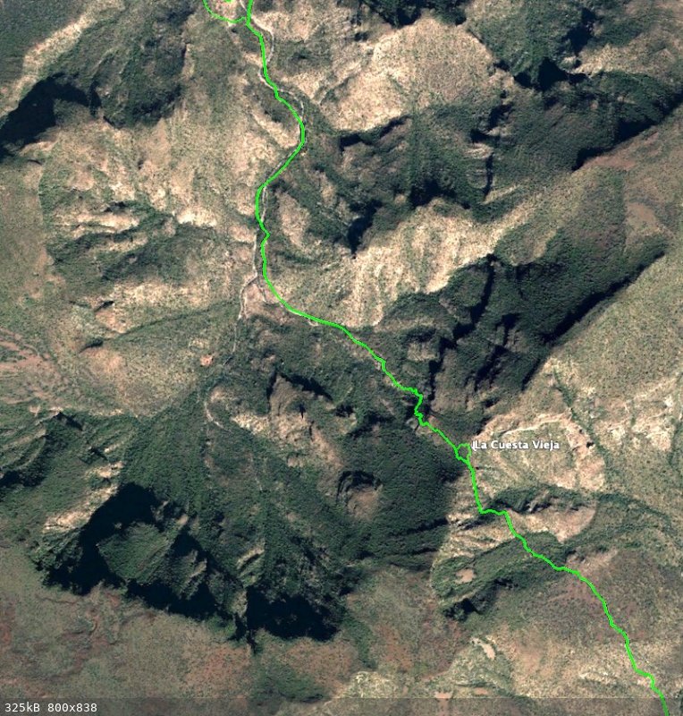
it started with noticing "Cañada La Cuesta Vieja", a canyon name indicating the presence of an old pass (Cuesta)
sure enough, I found the trail
I found more clues - I found more Camino Real
here is a list of all clues
Attachment: 888all clues for travel routes etc 270.kmz (33kB)
This file has been downloaded 161 times

[Edited on 11-3-2021 by 4x4abc]
Harald Pietschmann
|
|
|
David K
Honored Nomad
Posts: 64790
Registered: 8-30-2002
Location: San Diego County
Member Is Offline
Mood: Have Baja Fever
|
|
OK, so please explain what is happening when I click on one of your locations on Google Earth? Seems to change both time of image and orientation. Not
seeing any trail in the couple I looked at?
Also, the map you posted here is where on the peninsula?
Thanks... this is the kind of fun I like... Time Travel!
|
|
|
4x4abc
Ultra Nomad
Posts: 4283
Registered: 4-24-2009
Location: La Paz, BCS
Member Is Offline
Mood: happy - always
|
|
when you click on an image it will show the way and orientation i have recorded it (and the image layer that i used to record)
the trail is in a different data base
G12C39
Harald Pietschmann
|
|
|
4x4abc
Ultra Nomad
Posts: 4283
Registered: 4-24-2009
Location: La Paz, BCS
Member Is Offline
Mood: happy - always
|
|
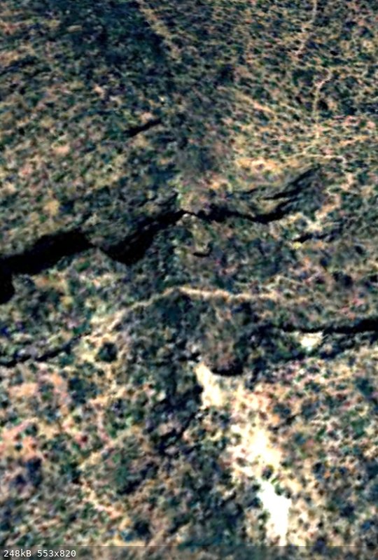
this is how the trail would look like
Harald Pietschmann
|
|
|
4x4abc
Ultra Nomad
Posts: 4283
Registered: 4-24-2009
Location: La Paz, BCS
Member Is Offline
Mood: happy - always
|
|
in order to locate the trail one needs to find the layer in Google Earth that has the least vegetation - in this case 2005
and there is no mistake - this is Camino Real
trail width is about 1.20 meters (4 feet)
Harald Pietschmann
|
|
|
mtgoat666
Select Nomad
Posts: 18281
Registered: 9-16-2006
Location: San Diego
Member Is Offline
Mood: Hot n spicy
|
|
Quote: Originally posted by 4x4abc  | I have been studying Baja California for a very long time
finding Camino Real on my own was very difficult
copying other ideas was not good enough for me
one of the important tools were the INEGI topo maps
they contained enough tools to pinpoint the most important branches of Camino Real
it started with noticing "Cañada La Cuesta Vieja", a canyon name indicating the presence of an old pass (Cuesta)
sure enough, I found the trail
I found more clues - I found more Camino Real
here is a list of all clues
[Edited on 11-3-2021 by 4x4abc] |
i looked, all I saw in KMZ file was named placemarks, and email symbols for each placemark, and the placemarks had no description or links. i saw no
KML paths between placemarks.
are your clues just names of locations w/o descriptions or citations?
Woke!
“...ask not what your country can do for you – ask what you can do for your country.” “My fellow citizens of the world: ask not what America
will do for you, but what together we can do for the freedom of man.”
Prefered gender pronoun: the royal we
|
|
|
4x4abc
Ultra Nomad
Posts: 4283
Registered: 4-24-2009
Location: La Paz, BCS
Member Is Offline
Mood: happy - always
|
|
| Quote: Originally posted by mtgoat666 |
i looked, all I saw in KMZ file was named placemarks, and email symbols for each placemark, and the placemarks had no description or links. i saw no
KML paths between placemarks.
are your clues just names of locations w/o descriptions or citations? |
the names of those placemarks are indicators for the Camino Real running through or close by
they helped me to look in the right places for signs on the ground for Camino Real
it was just one of the many first steps to find Camino Real
wanted to point out how difficult and involved it was to find that old road
I don't watch documentaries - I create them
Harald Pietschmann
|
|
|
David K
Honored Nomad
Posts: 64790
Registered: 8-30-2002
Location: San Diego County
Member Is Offline
Mood: Have Baja Fever
|
|
While Indian trails are also visible, the El Camino Real is a major deal, built to engineer's standards (of the 1700s). ECR routes were specific and
connected missions, visitas, and went via water sources.
The ECR built by the Jesuits ran straight as possible between these points, only deviating when a mountain or canyon prevented the straight run. At
those places, a series of switchbacks to climb the grade ('cuesta') were made.
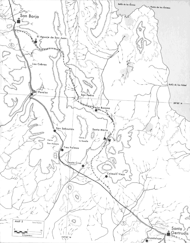
Between a couple of the missions were multiple El Camino Reals. From San Ignacio to Santa Gertrudis and then to San Borja, three choices were
available. The central route was known as the Sierra Camino Real, the western was the Pacifico Camino Real, and the eastern was the Golfo Camino Real.
Which one was used depended on the season, water availability, and what visitas or rancherias (Indian tribes/settlements) the padres wanted to visit.
On the Harry Crosby 1977 ECR map, two of the ECR routes are displayed (Sierra and Golfo). No map I have seen shows the Pacifico, which passed through
San Regis and San Ignacito...
|
|
|
David K
Honored Nomad
Posts: 64790
Registered: 8-30-2002
Location: San Diego County
Member Is Offline
Mood: Have Baja Fever
|
|
Harry provides some details on what was involved in building roads in Baja, in the 1700s:
https://web.archive.org/web/20160329013158/http://www.sandie...
The padres that came after the Jesuits were expelled, had no motivation to build constructed roads, except were absolutely necessary. There El Camino
Reals looked no better than cattle trails if they can be seen at all. North of El Rosario, modern roads and wetter climate has erased any signs in
most places. At La Misión, coming down the slope from the south to Mission San Miguel, is one exception.
|
|
|
4x4abc
Ultra Nomad
Posts: 4283
Registered: 4-24-2009
Location: La Paz, BCS
Member Is Offline
Mood: happy - always
|
|
you are just repeating Crosby's theory
I believe, he is largely wrong
working on the proof - give me some time
Harald Pietschmann
|
|
|
mtgoat666
Select Nomad
Posts: 18281
Registered: 9-16-2006
Location: San Diego
Member Is Offline
Mood: Hot n spicy
|
|
| Quote: Originally posted by David K | | While Indian trails are also visible, the El Camino Real is a major deal, built to engineer's standards (of the 1700s). |
ECR a major deal?
The engineering standard for roads was pretty advanced in 1700s and far exceeded what your padres built. Hell, look at Appian way built in 312 BC.
Look at what Aztecs had built in DF prior to Spanish destroying the city.
I think the ECR mostly followed pre-existing trails used by indigenous peoples. And the padres road improvements were limited to simple stone
clearing, minor grade leveling, and perhaps a few isolated cut/fills or minor field stone walls to facilitate easier equine travel.
Woke!
“...ask not what your country can do for you – ask what you can do for your country.” “My fellow citizens of the world: ask not what America
will do for you, but what together we can do for the freedom of man.”
Prefered gender pronoun: the royal we
|
|
|
David K
Honored Nomad
Posts: 64790
Registered: 8-30-2002
Location: San Diego County
Member Is Offline
Mood: Have Baja Fever
|
|
Read the page at the above link if you question my thoughts about it. That you can still see miles and miles of straight as an arrow road, 250+ years
later, across harsh desert terrain, even from space, speaks volumes.
The heavy-duty construction ended at or not far from San Borja, as the Jesuits were removed only a year after establishing the next mission north of
San Borja and did not have time to get their standard of road built. North of San Borja, Indian trails (such as the one above Pozo de Escuadra near
Mission Santa María) may have been the choice. Still, looking at a map, you see a major effort to be as direct as possible between missions.
Comparing this to Roman works in Europe is not even close to the fact that we had one European priest and maybe a craftsman along, using unskilled
labor, who may not even speak the same language. In Europe, you had the Roman Legion at your disposal.


|
|
|
4x4abc
Ultra Nomad
Posts: 4283
Registered: 4-24-2009
Location: La Paz, BCS
Member Is Offline
Mood: happy - always
|
|
Camino Real was a pretty lousy trail in today's standards
usually abour 4 ft wide , zig zagging through the country side
"straight" only refers to direction
the padres would rather go over a steep Mesa than around it, that's what straight means
if it were an engineering marvel, Fatboy would not have any planning trouble
ask Edie what she thinks about how advanced Camino Real is
I have been on it for 30+ years - it is not a an engineering masterpiece
below is a section cleaned up four tourists in San Ignacio

Harald Pietschmann
|
|
|
TMW
Select Nomad
Posts: 10659
Registered: 9-1-2003
Location: Bakersfield, CA
Member Is Offline
|
|
Show us a trail that meets today's standards for comparison.
|
|
|


