bajaktmrider
Newbie
Posts: 2
Registered: 11-6-2021
Member Is Offline
|
|
Bill Nichols Trail Info
Hi, The last two years I ran into new fences on the Bill Nichols trail Southbound between the mud hill and Catavina. There were also some "no motos"
signs and have heard stories of some aggressive ranchers who don't want people in there. Each time I hit a fence, I bailed out to the highway to
avoid any issues. Makes for a long way around. I am curious if anyone has more recent information. Last time I was there was Feb 2020. Just
curious if anyone has a good way to finish the trail without running into issues.
|
|
|
advrider
Super Nomad

Posts: 1847
Registered: 10-2-2015
Member Is Offline
|
|
Let me dig up my tracks, I have some that avoid the fence.
|
|
|
bajaktmrider
Newbie
Posts: 2
Registered: 11-6-2021
Member Is Offline
|
|
Thanks. I have a route around the northern fence. The southern fence I do not.
|
|
|
David K
Honored Nomad
Posts: 64488
Registered: 8-30-2002
Location: San Diego County
Member Is Offline
Mood: Have Baja Fever
|
|
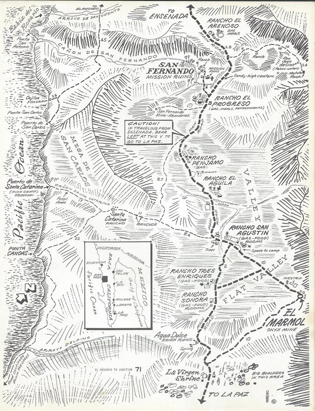
Not sure if it was the same fence or just the general area, but I wanted to drive the old Baja main road a few years ago. You can get on it on the
south end by the Cataviña Painted Cave and drive it north (it parallels Hwy. 1 about 1-2 miles to the east). Shortly after crossing the road to El
Mármol, it is fenced off by Rancho Tres Enriques. A detour around the north side via old San Agustín is required. The Baja Divide route does this.
|
|
|
David K
Honored Nomad
Posts: 64488
Registered: 8-30-2002
Location: San Diego County
Member Is Offline
Mood: Have Baja Fever
|
|
The "Three Henry's Ranch" popped up on maps after 1962 and before 1970.
When Mex 1 was built, they moved their business of serving travelers food and selling gasoline out to Hwy. 1, as did nearby Rancho Sonora and others
who were able to.
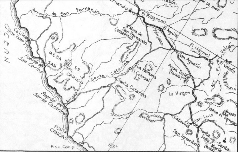
1962 Lower California Guidebook map, close up. Nothing between San Agustin and Agua Dulce.
About 20-some years ago the café caught on fire... The Three Henrys (Tres Enriques) moved back to the old original ranch location, back along the old
main road (over the hill from the highway).
In the revised (1967) Lower California Guidebook, only Rancho Sonora was mentioned as being a new place along here, in 1966. That would make Tres
Enriques new, somewhere from 1967 to 1969.
Here are the ranches along the old road to La Paz in a 1970 guide map (Cliff Cross):
[Edited on 2-19-2023 by David K]
|
|
|
David K
Honored Nomad
Posts: 64488
Registered: 8-30-2002
Location: San Diego County
Member Is Offline
Mood: Have Baja Fever
|
|
In 2005-2006, the military set up a checkpoint in front of the fire-damaged Tres Enriques... That didn't last long.
|
|
|
4x4abc
Ultra Nomad
Posts: 4165
Registered: 4-24-2009
Location: La Paz, BCS
Member Is Offline
Mood: happy - always
|
|
Tres Enriquez
"z"
Harald Pietschmann
|
|
|
David K
Honored Nomad
Posts: 64488
Registered: 8-30-2002
Location: San Diego County
Member Is Offline
Mood: Have Baja Fever
|
|
Not always, do a Google Search...
|
|
|
4x4abc
Ultra Nomad
Posts: 4165
Registered: 4-24-2009
Location: La Paz, BCS
Member Is Offline
Mood: happy - always
|
|
https://mapcarta.com/35040102
Harald Pietschmann
|
|
|
4x4abc
Ultra Nomad
Posts: 4165
Registered: 4-24-2009
Location: La Paz, BCS
Member Is Offline
Mood: happy - always
|
|
sic

Harald Pietschmann
|
|
|
David K
Honored Nomad
Posts: 64488
Registered: 8-30-2002
Location: San Diego County
Member Is Offline
Mood: Have Baja Fever
|
|
All good stuff... I am only spelling it the way I had seen it spelled on the side of their restaurant/ rancho. Highway signs, too. Never with a 'Z'
and the Mexican topo map is so full of other errors, it is hard to allow it to be a judge. However, I did not alter that spelling when I edited the
new Baja Atlas. Who knows, maybe the ranch spells it that way, now?
No, wait... they STILL spell it with an S: https://www.facebook.com/Rancho-3-Enriques-BC-27217814280543...
|
|
|
David K
Honored Nomad
Posts: 64488
Registered: 8-30-2002
Location: San Diego County
Member Is Offline
Mood: Have Baja Fever
|
|
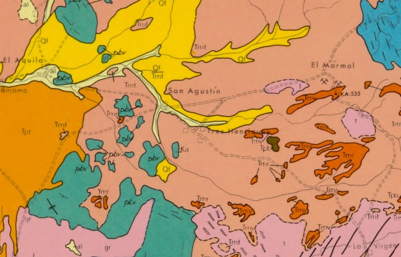
On a 1971 Geology Map: Tres Henriques
Why not add an H, it's silent in Spanish! The ending with an S vs. a Z, is the important part... 
|
|
|
4x4abc
Ultra Nomad
Posts: 4165
Registered: 4-24-2009
Location: La Paz, BCS
Member Is Offline
Mood: happy - always
|
|
how about a highway sign, David?
Harald Pietschmann
|
|
|
AKgringo
Elite Nomad
Posts: 5815
Registered: 9-20-2014
Location: Anchorage, AK (no mas!)
Member Is Offline
Mood: Retireded
|
|
I have always thought that an English version of "Enrique" would be Henry.
The original poster is probably wondering what the H this has to do with the gates!
If you are not living on the edge, you are taking up too much space!
"Could do better if he tried!" Report card comments from most of my grade school teachers. Sadly, still true!
|
|
|
4x4abc
Ultra Nomad
Posts: 4165
Registered: 4-24-2009
Location: La Paz, BCS
Member Is Offline
Mood: happy - always
|
|
social media is just another form of taking together
and like any other conversation, it goes from G to R, back to G and then to P (politics)
you could bring it back to gates if you have info
I would be interested
Harald Pietschmann
|
|
|
David K
Honored Nomad
Posts: 64488
Registered: 8-30-2002
Location: San Diego County
Member Is Offline
Mood: Have Baja Fever
|
|
Do you have a photo?
How about Street View... can you go back in time on it like on GE?
I remember certain Baja details, like place names. I think I would remember if I saw it spelled with a Z, since I like to draw maps.
|
|
|
David K
Honored Nomad
Posts: 64488
Registered: 8-30-2002
Location: San Diego County
Member Is Offline
Mood: Have Baja Fever
|
|
Quote: Originally posted by AKgringo  | I have always thought that an English version of "Enrique" would be Henry.
The original poster is probably wondering what the H this has to do with the gates! |
I see it as both Harry and Henry when doing translation views... It does sound more like Henry, to me!
The gates are near Tres Enriques, I think?
|
|
|
4x4abc
Ultra Nomad
Posts: 4165
Registered: 4-24-2009
Location: La Paz, BCS
Member Is Offline
Mood: happy - always
|
|
Street View does not have a sign for the three bothers
Harald Pietschmann
|
|
|
David K
Honored Nomad
Posts: 64488
Registered: 8-30-2002
Location: San Diego County
Member Is Offline
Mood: Have Baja Fever
|
|
Tres Enriques
In January, 2006, Elizabeth and I went to El Mármol and El Volcán from El Rosario.
Besides the trip report here, I made a web page http://vivabaja.com/marmol/ to share the photos, a map, and this road log... Tres Enriques is on it:
Road Log (Miles)
0.0 El Rosario Pemex Station
14.6 Punta San Carlos Jcn.
28.5 Los Mártires, San Juan de Dios Jcn.
31.5 El Descanso
31.6 Monument to Hector
37.8 Old Road to right, Mision San Fernando access
39.4 El Progreso, signed San Fernando road
46.2 Santa Catarina Jcn. (original shipping point for El Marmol's onyx)
46.4 Guayaquil Jcn. (new home for many of El Mármol's residents after 1958)
54.2 San Agustin abandoned trailer park
54.3 Abandoned gas station San Agustin
54.4 San Agustin highway maintenance complex
56.1 Military Checkpoint at abandoned Tres Enriques cafe
56.5 EL MARMOL JCN. (signed 15 kms.), just beyond is the Cafe Sonora
9.3 from Hwy. 1 is EL MARMOL at 29°58.20', 114°48.53', elev. 2,190'
4.0 from El Mármol is Arroyo El Volcán (take right fork at mi. 2.0)
0.4 to the right/south, up the arroyo, is EL VOLCAN at 29°59.55', 114°46.22', elev. 1,885'
|
|
|


