philodog
Nomad

Posts: 163
Registered: 10-9-2010
Member Is Offline
|
|
Good map apps for offline use?
What are some good map apps you can download baja satellite images to so an internet connection isn't required?
|
|
|
JZ
Elite Nomad
Posts: 9230
Registered: 10-3-2003
Member Is Offline
|
|
Gaia and Back Country Navigator are the best.
BCN is my favorite. More ppl use Gaia.
[Edited on 11-10-2021 by JZ]
|
|
|
philodog
Nomad
Posts: 163
Registered: 10-9-2010
Member Is Offline
|
|
Thanks JZ. Just checked both of their websites and it seems only Gaia has satellite images? Do you know if BCN does?
|
|
|
John M
Super Nomad
Posts: 1906
Registered: 9-3-2003
Location: California High Desert
Member Is Offline
|
|
Sat images
GAIA has a free app with topo maps only.
Adding layers to include satellite images is a paid subscription.
John M
|
|
|
JZ
Elite Nomad
Posts: 9230
Registered: 10-3-2003
Member Is Offline
|
|
Quote: Originally posted by philodog  | | Thanks JZ. Just checked both of their websites and it seems only Gaia has satellite images? Do you know if BCN does? |
BCN has satellite images. I have downloaded images for all of Baja. It's about 60G of data. Took me 2-3 days to do it, as you can only download a
certain size area at a time. I then copied the data from my phone to my laptop, so I could load up other devices very quickly.
Also have the Topo maps downloaded for all of Baja, much smaller data requirement, 1 or 2G I think.
I use the classic BCN which is Android only (unless they changed that recently). Their newer app is both iPhone and Android.
Both Gaia and BCN are very similar to each other.
Having the satellite images on your phone or tablet is a game changer. You can see yourself riding a bike through a canyon by glancing at your phone
mounted on your handle bar, or approaching a deserted beach on a boat looking at the tablet on the dash. 1000x better than just topo maps.
|
|
|
PaulW
Ultra Nomad
Posts: 3005
Registered: 5-21-2013
Member Is Offline
|
|
Best Nav enabled map that shows the most Baja backcountry roads would be MapE32 with the $61 layers payment. Shows up with good contrast on your car
nav system / Apple Play. Works for most all tablets.
Based on my testing and use E32 is better with payment than the following:
Gaia ($40), Google maps ($0), Maps.me ($0), Earthmate (requires inReach account - expensive). Back Country Navigator XE ($10+maps - no carplay), Open
Street Map - OSM ($40)
Avenza maps for iPhone ($20) is a special case - No Apple play or Nav- just works on your iPhone. Great images. It is a digital version of Baja Atlas
by Benchmark
Best images and most backcountry roads is Avenza
With payment OSM gives you trails the others have loaded that are real GPX tracks that many of us have driven. Fun app.
Some of the above apps will work on Android so give them a try.
[Edited on 11-10-2021 by PaulW]
|
|
|
PaulW
Ultra Nomad
Posts: 3005
Registered: 5-21-2013
Member Is Offline
|
|
Some of the apps have sat view layer if you like the color. It will not help you navigate. At least one requires sat view to get the backcountry
roads. Buy and test to find your prefrence.
|
|
|
100X
Nomad
Posts: 234
Registered: 11-3-2021
Member Is Offline
Mood: Thankful
|
|
On X good too.
A life of fears leads to a death bed of regrets.
Find someone who will take care of you, and take care of them.
|
|
|
PaulW
Ultra Nomad
Posts: 3005
Registered: 5-21-2013
Member Is Offline
|
|
BCNXE is the laterst offering and probably will replace the Andriod only version that they started with.
|
|
|
bajaric
Senior Nomad
Posts: 602
Registered: 2-2-2015
Member Is Offline
|
|
I am a paper map guy, but am leaning towards getting the Avenza digital version of the Benchmark Atlas. The paper version is a little hard to read
but it has great detail on roads.
I was driving west on Hwy 3 a month ago, and wanted to turn north at the km 55 turnoff to Laguna Hanson. However, it has a big dirt berm and a fence
across it now! So I broke out the Benchmark map, found an access at km 46, signed Vincola winery that went to the Laguna Hanson Rd. via the "Coyote
Junction" near "El Coyote". So I drove north a ways, then east, took wrong turn at "Poblada Puerta Trampa" a tiny farm town and got lost on some
dirt roads among the trash dumps on the outskirts of Puerta Trampa.
I used my GPS to determine my lat / long and using the coordinates on the edge of the map I could actually see the tiny dirt road I was on and found
my way back to the main road. It is not a satellite map but pretty impressive accuracy as a road map.
One criticism is that Benchmark dropped the names of many places, for example, it does not show El Coyote, a cluster of dwellings just south of La
Huerta and a well known landmark at a junction that is shown on many other maps.
I wonder why someone closed the main access road to the National Park from the south? The berm and fence looked like an amateur job, just sticks and
barbed wire. Now you have to approach the Laguna Hanson Rd. via Puerta Trampa coming up from Valle Ojos Negros.
[Edited on 11-10-2021 by bajaric]
|
|
|
David K
Honored Nomad
Posts: 64479
Registered: 8-30-2002
Location: San Diego County
Member Is Offline
Mood: Have Baja Fever
|
|
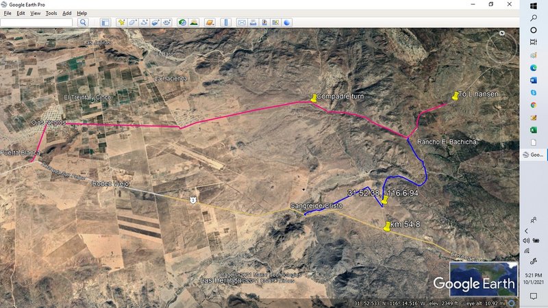
Now use Km. 51.4 to replace Km. 54.8
| Quote: Originally posted by bajaric | I am a paper map guy, but am leaning towards getting the Avenza digital version of the Benchmark Atlas. The paper version is a little hard to read
but it has great detail on roads.
I was driving west on Hwy 3 a month ago, and wanted to turn north at the km 55 turnoff to Laguna Hanson. However, it has a big dirt berm and a fence
across it now! So I broke out the Benchmark map, found an access at km 46, signed Vincola winery that went to the Laguna Hanson Rd. via the "Coyote
Junction" near "El Coyote". So I drove north a ways, then east, took wrong turn at "Poblada Puerta Trampa" a tiny farm town and got lost on some
dirt roads among the trash dumps on the outskirts of Puerta Trampa.
I used my GPS to determine my lat / long and using the coordinates on the edge of the map I could actually see the tiny dirt road I was on and found
my way back to the main road. It is not a satellite map but pretty impressive accuracy as a road map.
One criticism is that Benchmark dropped the names of many places, for example, it does not show El Coyote, a cluster of dwellings just south of La
Huerta and a well known landmark at a junction that is shown on many other maps.
I wonder why someone closed the main access road to the National Park from the south? The berm and fence looked like an amateur job, just sticks and
barbed wire. Now you have to approach the Laguna Hanson Rd. via Puerta Trampa coming up from Valle Ojos Negros.
|
On 10-1-21, PaulW informed us of the detour to bypass that blocked road:
(last posts in this thread) http://forums.bajanomad.com/viewthread.php?tid=96645
| Quote: Originally posted by PaulW | Hwy 3 to L Hansen
Exit Hwy 3 at Km51.4. The road to Sangre de Cristo. 31 52.208, -116 8.897
And from the turn to Ojos Negro Km 39.5. 31 53.488, -116 16498
|
|
|
|
bajaric
Senior Nomad
Posts: 602
Registered: 2-2-2015
Member Is Offline
|
|
Excellent shortcut! However, there is now another berm across the road at Coyote junction blocking access south to Hwy 3 that is impassable (unless
you are driving a lifted jeep--) I think that is the point where the blue line meets the pink line on Paul's map. It would be a bummer to get in
there and have to turn around.
I took the route shown by the pink line after cutting over from about Km45.
I missed the little jog south at Puerto Trampa and ended up out among the trash piles. Taking this route is somewhat of a pain if you are arriving
from the east because it adds several miles on dusty washboard dirt roads in Valle Ojos Negros to get to Laguna Hanson.
I just carry a little Nuvi GPS to get latitude and longitude, then use the Benchmark map to figure out where I am. Or, if going to a really remote
area where the roads are not shown even on the Benchmark map I "snip" a satellite view from Google Earth and print it out and mark the GPS coordinates
for critical road junctions on it. Then when I get to the junction I know where to turn by using the Nuvi to determine my latitude and longitude.
The Nuvi has an annoying tendency to show the last place you were instead of your current location, so have to be aware of that and make sure it is
showing your current location not where you just came from.
[Edited on 11-10-2021 by bajaric]
|
|
|
David K
Honored Nomad
Posts: 64479
Registered: 8-30-2002
Location: San Diego County
Member Is Offline
Mood: Have Baja Fever
|
|
The Benchmark map download (on Avenza) has cross hair and uses the phone GPS to show you where you are on the Benchmark map and gives the GPS waypoint
at the bottom. E-Z Pee-Zee
|
|
|
advrider
Super Nomad
Posts: 1847
Registered: 10-2-2015
Member Is Offline
|
|
I use OSMAND on my phone and E-32 on my Garmin. I like the ease of use on the OSMAND paid app and E-32 for the Garmin to have a second map as a back
up.
|
|
|
BajaMama
Super Nomad
Posts: 1106
Registered: 10-4-2015
Location: Pleasanton/Punta Chivato
Member Is Offline
Mood: Got Baja fever!!
|
|
We use GAIA on an old cell enabled iPad - cell enabled necessary because it has GPS.
|
|
|
StuckSucks
Super Nomad
Posts: 2306
Registered: 10-17-2013
Member Is Offline
|
|
I've used Gaia GPS for around 10 years - I started using it while working for an off road race team in Baja. It's very affordable and works great
off-line. I can preload background maps from a large selection of different maps, so no internet connection is needed.
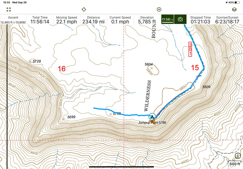
I recently purchased a new iPad Air and hard-wired it into the truck. Here's a recent screen shot of the app while we were recently visiting the North
Rim of the Grand Canyon. The blue line is my breadcrumbs, the gold triangle is the truck's location. Across the top are my trip stats.
|
|
|
StuckSucks
Super Nomad
Posts: 2306
Registered: 10-17-2013
Member Is Offline
|
|
Hummm ... makes me wonder: how many times can I use the word "recently?"
|
|
|


