ThePanamerican
Newbie
Posts: 2
Registered: 11-23-2021
Member Is Offline
|
|
Parque Nacional de Constitucion 1857 - Possible to Access with 2WD?
Hey guys,
Will be exploring Baja next year in my Kia Forte. Would like to access Parque Nacional de Constitucion 1857 on my way to San Felipe, the turnoff just
past Ojos Negros. Does anyone know if the road quality is sufficient for a FWD vehicle in November?
Also, it appears that the road is blocked off, at least according to the Google Maps screenshot:
https://www.google.com/maps/@31.8640418,-116.1156405,3a,49.5...
Is it only accessible from the North(La Rumorosa area)?
Thank you for any wisdom you all can bestow. Have a great week.
|
|
|
Maderita
Senior Nomad

Posts: 634
Registered: 12-14-2008
Location: San Diego
Member Is Offline
|
|
I would not recommend doing that road in a Kia Forte, (unless it's a rental car hahaha). Some years, such as this one, it is quite dry. Other years
there is snow by Thanksgiving. Elevations exceed 5,000'. Deep mud is likely after significant rains.
If conditions are dry next November, then a sedan could do it just fine by taking it slow and easy.
That turnoff from Highway 3 has been blocked intermittently and reopened. The alternate route departs from Ojos Negros. David will likely post a map

If crossing from the USA and going to San Felipe, perhaps consider driving Highway 2 to La Rumorosa, then south from there, passing through the Parque
Nacional to Highway 3.
|
|
|
David K
Honored Nomad
Posts: 64490
Registered: 8-30-2002
Location: San Diego County
Member Is Offline
Mood: Have Baja Fever
|
|
Paul, an Aug. 2021 street view image show a big gate there, signed Sangre de Cristo. Is this unlocked and you passed through?

|
|
|
AKgringo
Elite Nomad
Posts: 5819
Registered: 9-20-2014
Location: Anchorage, AK (no mas!)
Member Is Offline
Mood: Retireded
|
|
I drove that road once in my Kia Sportage. It is the older version, which is based on a Mazda light truck frame and running gear. I did not need
4x4, but I am glad I had the clearance to negotiate the steeper, rocky stretches of the road.
At one point, I found myself following an oil trail that ended at a sedan with a punctured oil pan. I think it was transmission fluid, but I am not
sure.
The young couple in the car were apparently locals, and had a cell connection and help on the way.
If you are not living on the edge, you are taking up too much space!
"Could do better if he tried!" Report card comments from most of my grade school teachers. Sadly, still true!
|
|
|
David K
Honored Nomad
Posts: 64490
Registered: 8-30-2002
Location: San Diego County
Member Is Offline
Mood: Have Baja Fever
|
|
OK. Paul informs us that he only recommends going in from Ojos Negros. The Sangre de Cristo gate prevents any shorter bypass.
|
|
|
AKgringo
Elite Nomad
Posts: 5819
Registered: 9-20-2014
Location: Anchorage, AK (no mas!)
Member Is Offline
Mood: Retireded
|
|
Correction....
I did not read the original post correctly before my previous reply. The bad road that I was referring to was the one running from near La Rumorosa,
headed south to Parque National, Laguna Hanson.
I continued south through Ojos Negros, and the road at that time was pretty good on the southern end. I have no current knowledge of how it is now!
[Edited on 11-24-2021 by AKgringo]
If you are not living on the edge, you are taking up too much space!
"Could do better if he tried!" Report card comments from most of my grade school teachers. Sadly, still true!
|
|
|
Maderita
Senior Nomad
Posts: 634
Registered: 12-14-2008
Location: San Diego
Member Is Offline
|
|
Quote: Originally posted by AKgringo  | | ...The bad road that I was referring to was the one running from near La Rumorosa, headed south to Parque National, Laguna Hanson...
|
Driving south from La Rumorosa, there is a short rough section at approx. mile 5. Drive slowly on that section and keep the tires on the high ground,
not down in the ruts. Avoid taking rocks down the center of the vehicle (note AKgringo's above post). Sedans regularly travel that road during the dry
months. The road is fairly well graded to KM 38. It was last graded in early summer, 2021. Due to the ejidos' budget constraints, it had been two
years since the previous grading work.
At KM 38, there is a short (100m) steep section which was improved with concrete many years ago. Just beyond that, the road begins to climb up a long
hill. The road splits into 3 paths for a few hundred meters. Do not take the left (east) path due to loose large rocks. The remaining distance to
Laguna Hanson is often rough with ruts, but there are no obstacles, except for mud holes in the wet season.
|
|
|
ThePanamerican
Newbie
Posts: 2
Registered: 11-23-2021
Member Is Offline
|
|
Wow! Numerous great replies. Thank you everyone!
|
|
|
AKgringo
Elite Nomad
Posts: 5819
Registered: 9-20-2014
Location: Anchorage, AK (no mas!)
Member Is Offline
Mood: Retireded
|
|
It just occurred to me that my very first post on Baja Nomad was to ask about this very same road. I was also blown away by the immediate, helpful
advice and info that came my way.
Sometimes this forum rocks!
[Edited on 11-24-2021 by AKgringo]
If you are not living on the edge, you are taking up too much space!
"Could do better if he tried!" Report card comments from most of my grade school teachers. Sadly, still true!
|
|
|
Maderita
Senior Nomad
Posts: 634
Registered: 12-14-2008
Location: San Diego
Member Is Offline
|
|
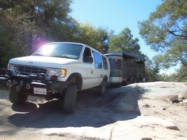
De nada PanAm.
This is the short section at KM 38. No big deal since the 1990s. Just a bit tight with this rig towing 6 horses.
|
|
|
AKgringo
Elite Nomad
Posts: 5819
Registered: 9-20-2014
Location: Anchorage, AK (no mas!)
Member Is Offline
Mood: Retireded
|
|
Nice set up...and in a pinch, you have six draft horses to help you out!
If you are not living on the edge, you are taking up too much space!
"Could do better if he tried!" Report card comments from most of my grade school teachers. Sadly, still true!
|
|
|
bajaric
Senior Nomad
Posts: 605
Registered: 2-2-2015
Member Is Offline
|
|
As I pointed out in a post just a few weeks ago even if you could access the road at Sange de Christo there is a dirt berm blocking access at the
point shown on the map above as Rancho Bachicha (aka Coyote Junction). Closest access is at km 45, the road that can be seen just west of the airport
on the map.
Right now, you could make it to Laguna Hanson from the south in a Dodge Neon. A year from now is anyone's guess. Conditions change.
I am not sure why the road at km 55 has been gated. It might be an ejido thing or perhaps an indigenous tribe exercising their sovereign rights. The
Kiliwa tribe has some lands in that area. These are people that live in the southern Sierra Juarez, descended from people that lived in the same
mountains before the time of Columbus.
[Edited on 11-24-2021 by bajaric]
|
|
|
David K
Honored Nomad
Posts: 64490
Registered: 8-30-2002
Location: San Diego County
Member Is Offline
Mood: Have Baja Fever
|
|
Edits based on roadblock report
I am editing my Baja Bound article on Laguna Hanson https://www.bajabound.com/bajaadventures/bajatravel/laguna_h...
and the future road guide with this (or something close):
Update: In 2021, the road at Km. 54.5 of Highway 3 was blocked, requiring a detour through Ojos Negros, beginning at Km. 39.5. This detour joins the
road to Laguna Hanson at Mile 3.8 of the following log, adding approx. 8.3 miles to the figures.
The following road log and photos are from August 2018 and goes from Hwy. 3 north to Hwy. 2
Mile 0.0 Highway 3 at Km. 54.5, east of Ensenada.
Mile 2.7 Fork left.
Mile 3.8 Fork right. [Mile 12.1 via Km. 39.5 & Ojos Negros, Fork Left]
Mile 4.8 Oak trees.
Mile 5.2 Fork left. Elev. 4,000'.
Mile 11.2 Pine trees begin. Elev. 5,000’.
Mile 13.7 Rancho El Rayo.
Mile 15.1 Road southeast to Rancho La Botella. Cattle Guard crossing.
Mile 16.2 Aserradero an abandoned saw mill town with some tourist services. Food.
Mile 17.5 Cabins, market, food.
Mile 19.8 Laguna Hanson: park headquarters, cabins, daily use fee 64 pesos. Elev. 5,300’.
|
|
|
PaulW
Ultra Nomad
Posts: 3009
Registered: 5-21-2013
Member Is Offline
|
|
From the South

|
|
|
David K
Honored Nomad
Posts: 64490
Registered: 8-30-2002
Location: San Diego County
Member Is Offline
Mood: Have Baja Fever
|
|
Today (Feb. 7, 2022) the road was reported open, no more block.
|
|
|
mjs
Nomad
Posts: 305
Registered: 2-20-2013
Location: Off grid in San Felipe
Member Is Offline
|
|
The dirt barricade was gone when we went by on Jan 27, 2022.
|
|
|
David K
Honored Nomad
Posts: 64490
Registered: 8-30-2002
Location: San Diego County
Member Is Offline
Mood: Have Baja Fever
|
|
It is so appreciated when Baja Nomads share road conditions, changes, closures with us.
|
|
|
PaulW
Ultra Nomad
Posts: 3009
Registered: 5-21-2013
Member Is Offline
|
|
A very curious event
|
|
|
bajaric
Senior Nomad
Posts: 605
Registered: 2-2-2015
Member Is Offline
|
|
It does seem odd that someone would block the main signed road to a national park with a dirt berm and a fence made out of sticks.
Who knows? Es Mexico.
When I found the road at Km 54/55 to be blocked, I traveled west on Hwy 3 to a turnoff at Km 45 signed "Vinicola" then north past the airport to the
road noted on Paul's map in red, without having to go all the way to Ojos Negros at Km 40.
Traveling east on the red road goes past a small ejido called Poblado Puerta Trampa (Bemchmark) aka San Jose (Baja California Almanac).
[Edited on 2-8-2022 by bajaric]
|
|
|


