| Pages:
1
2 |
freediverbrian
Senior Nomad

Posts: 615
Registered: 2-24-2007
Location: Papas Gonzaga Bay
Member Is Offline
|
|
#10 is San Felipe. Someone guessed Pete's camp but I guess not Close enough for this game.
|
|
|
4x4abc
Ultra Nomad
Posts: 4166
Registered: 4-24-2009
Location: La Paz, BCS
Member Is Offline
Mood: happy - always
|
|
#5
the lat/long you are giving us is at the highest point of the Cuesta.
All "walls" are on the downhill side about 3/4 mile away
at your location no wall features are visible
they are first found here: 28.375926°, -113.105787°
"wall" visible as seen below
several more follow east from there
28.375396°, -113.102407°
28.374301°, -113.075278°
28.379019°, -113.075074°
28.373842°, -113.072767°
28.375943°, -113.086850°

Harald Pietschmann
|
|
|
David K
Honored Nomad
Posts: 64490
Registered: 8-30-2002
Location: San Diego County
Member Is Offline
Mood: Have Baja Fever
|
|
Maybe I was too harsh? Pete's camp was the guess and that is a very specific spot, so I said that was too far north, and so it was... The photo is on
San Felipe Bay and that is between Punta El Machorro (aka Punta San Felipe) and Punta Estrella.
|
|
|
David K
Honored Nomad
Posts: 64490
Registered: 8-30-2002
Location: San Diego County
Member Is Offline
Mood: Have Baja Fever
|
|
Quote: Originally posted by 4x4abc  | #5
the lat/long you are giving us is at the highest point of the Cuesta.
All "walls" are on the downhill side about 3/4 mile away
at your location no wall features are visible
they are first found here: 28.375926°, -113.105787°
"wall" visible as seen below
several more follow east from there
28.375396°, -113.102407°
28.374301°, -113.075278°
28.379019°, -113.075074°
28.373842°, -113.072767°
|
On my Google Earth, the crosshairs were on the wall...?? I guess our computers are seeing a difference?
[Edited on 6-10-2022 by David K]
|
|
|
Mateo-Feo
Nomad
Posts: 101
Registered: 8-1-2012
Location: San diego
Member Is Offline
Mood: MuchoTakeitEasy
|
|
#6 Road to La Mision San Francisco Borja
|
|
|
David K
Honored Nomad
Posts: 64490
Registered: 8-30-2002
Location: San Diego County
Member Is Offline
Mood: Have Baja Fever
|
|
Indeed it is! The north road to the mission, traveling south in the photo.
|
|
|
David K
Honored Nomad
Posts: 64490
Registered: 8-30-2002
Location: San Diego County
Member Is Offline
Mood: Have Baja Fever
|
|
We need hints for #1, 3, & 9?
#1 is in Baja (Norte), once the major north-south road on that side of the peninsula, and a frequent checkpoint and pit location for the 1000.
#3 is in Baja Sur, a popular place for pangas to off-load their catch, and an interesting church is nearby.
#9 is in Baja (Norte), on a side road to a bay and some mysterious walls.
MORE HINTS:
#1 got its name (for the road junction) from a small business here selling gas, before the highway was built in 1973. It was the south end of the most
common used "gulf route" (1958- 1983) that is now Hwy. 5, using a different route since 1983.
#3 Fishermen use this place as it is very sheltered and an old church nearby was restored a few years ago.
#9 A dead end road to a beautiful beach location. Seasonal fish camp. The Dana Point High School marine biology class used to come here on Spring
break.
|
|
|
Mateo-Feo
Nomad
Posts: 101
Registered: 8-1-2012
Location: San diego
Member Is Offline
Mood: MuchoTakeitEasy
|
|
| Quote: Originally posted by David K | We need hints for #1, 3, & 9?
#1 is in Baja (Norte), once the major north-south road on that side of the peninsula, and a frequent checkpoint and pit location for the 1000.
#3 is in Baja Sur, a popular place for pangas to off-load their catch, and an interesting church is nearby.
#9 is in Baja (Norte), on a side road to a bay and some mysterious walls.
MORE HINTS:
#1 got its name (for the road junction) from a small business here selling gas, before the highway was built in 1973. It was the south end of the most
common used "gulf route" (1958- 1983) that is now Hwy. 5, using a different route since 1983.
#3 Fishermen use this place as it is very sheltered and an old church nearby was restored a few years ago.
#9 A dead end road to a beautiful beach location. Seasonal fish camp. The Dana Point High School marine biology class used to come here on Spring
break. |
#9 Bahia Las Animas
|
|
|
David K
Honored Nomad
Posts: 64490
Registered: 8-30-2002
Location: San Diego County
Member Is Offline
Mood: Have Baja Fever
|
|
| Quote: Originally posted by Mateo-Feo | | Quote: Originally posted by David K | We need hints for #1, 3, & 9?
#1 is in Baja (Norte), once the major north-south road on that side of the peninsula, and a frequent checkpoint and pit location for the 1000.
#3 is in Baja Sur, a popular place for pangas to off-load their catch, and an interesting church is nearby.
#9 is in Baja (Norte), on a side road to a bay and some mysterious walls.
MORE HINTS:
#1 got its name (for the road junction) from a small business here selling gas, before the highway was built in 1973. It was the south end of the most
common used "gulf route" (1958- 1983) that is now Hwy. 5, using a different route since 1983.
#3 Fishermen use this place as it is very sheltered and an old church nearby was restored a few years ago.
#9 A dead end road to a beautiful beach location. Seasonal fish camp. The Dana Point High School marine biology class used to come here on Spring
break. |
#9 Bahia Las Animas |
Correct! 
|
|
|
AKgringo
Elite Nomad
Posts: 5819
Registered: 9-20-2014
Location: Anchorage, AK (no mas!)
Member Is Offline
Mood: Retireded
|
|
Your latest hints narrow down the options for #3. It must be San Roque!
I spent a couple of nights camped out in front of the old church before it was restored.
If you are not living on the edge, you are taking up too much space!
"Could do better if he tried!" Report card comments from most of my grade school teachers. Sadly, still true!
|
|
|
David K
Honored Nomad
Posts: 64490
Registered: 8-30-2002
Location: San Diego County
Member Is Offline
Mood: Have Baja Fever
|
|
| Quote: Originally posted by AKgringo | Your latest hints narrow down the options for #3. It must be San Roque!
I spent a couple of nights camped out in front of the old church before it was restored. |
It is!
|
|
|
Mateo-Feo
Nomad
Posts: 101
Registered: 8-1-2012
Location: San diego
Member Is Offline
Mood: MuchoTakeitEasy
|
|
#1 -- What is "La Curva" for 1000 David?
|
|
|
David K
Honored Nomad
Posts: 64490
Registered: 8-30-2002
Location: San Diego County
Member Is Offline
Mood: Have Baja Fever
|
|
Sorry... but at least you put in the form of a question! 
It is a typical name for a road junction. There was a ranch (using the same name) located just out of sight of the highway but was abandoned in 2016
when we drove past it.
Edit: Here are the two hints, again:
#1 is in Baja (Norte), once the major north-south road on that side of the peninsula, and a frequent checkpoint and pit location for the 1000.
#1 got its name (for the road junction) from a small business here selling gas, before the highway was built in 1973. It was the south end of the most
common used "gulf route" (1958- 1983) that is now Hwy. 5, using a different route since 1983.
[Edited on 7-7-2022 by David K]
|
|
|
Mateo-Feo
Nomad
Posts: 101
Registered: 8-1-2012
Location: San diego
Member Is Offline
Mood: MuchoTakeitEasy
|
|
Oh gawd, please tell me it's not Coco's Corner. I feel stupid
|
|
|
David K
Honored Nomad
Posts: 64490
Registered: 8-30-2002
Location: San Diego County
Member Is Offline
Mood: Have Baja Fever
|
|
No... but you can see the old maps from AAA (1974-2000) that give the name... as I said, it is the SOUTH END of the GULF ROUTE prior to 1983 (when
they bulldozed the road from Laguna Chapala to the road in question, south of Gonzaga Bay, where Coco's first Corner would be set up many years
later). There was a poor, 4x4 road from/ to Laguna Chapala before they built a new one by 1983.
|
|
|
David K
Honored Nomad
Posts: 64490
Registered: 8-30-2002
Location: San Diego County
Member Is Offline
Mood: Have Baja Fever
|
|
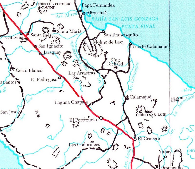
OK, let's put this one to bed... The south end of the former gulf road and a frequent checkpoint or pit location for the Baja 1000 is EL CRUCERO.
Here it is on a 1975 guidebook map:
[Edited on 7-8-2022 by David K]
|
|
|
AKgringo
Elite Nomad
Posts: 5819
Registered: 9-20-2014
Location: Anchorage, AK (no mas!)
Member Is Offline
Mood: Retireded
|
|
I did not connect that junction with any name, even though I have been through there several times (as recently as Nov 2021)
That photo looks like so many other places in Baja, it would be hard to make a positive ID of it.
It was a fun game, just a little tougher than some of your other sets of photos!
If you are not living on the edge, you are taking up too much space!
"Could do better if he tried!" Report card comments from most of my grade school teachers. Sadly, still true!
|
|
|
bajaric
Senior Nomad
Posts: 605
Registered: 2-2-2015
Member Is Offline
|
|
I thought maybe #1 was the Sierra la Asemblea! Usually am too lazy to log on here and post a reply. El Crucero is shown on most older maps, but the
new Benchmark Atlas does not show it. Benchmark dropped a quite a few of the old historic ranchos shown on the BCA and INEGI maps.
[Edited on 7-8-2022 by bajaric]
|
|
|
David K
Honored Nomad
Posts: 64490
Registered: 8-30-2002
Location: San Diego County
Member Is Offline
Mood: Have Baja Fever
|
|
| Quote: Originally posted by bajaric | I thought maybe #1 was the Sierra la Asemblea! Usually am too lazy to log on here and post a reply. El Crucero is shown on most older maps, but the
new Benchmark Atlas does not show it. Benchmark dropped a quite a few of the old historic ranchos shown on the BCA and INEGI maps.
[Edited on 7-8-2022 by bajaric] |
Well, the mountain in the background is!
Since El Crucero is no longer there, the ranch was abandoned, it didn't strike me as an urgent need to add the name back to the spot. The base map is
from INEGI and I made suggestions for additions or edits. We can very easily add El Crucero to that spot, just with a suggestion to Benchmark for the
second edition.
|
|
|
| Pages:
1
2 |


