David K
Honored Nomad
        
Posts: 64790
Registered: 8-30-2002
Location: San Diego County
Member Is Offline
Mood: Have Baja Fever
|
|
Mission Santiago and a confusing history for some!
From my Baja Missions Group on Facebook, as I know there are some who do not read Facebook... https://www.facebook.com/groups/bajamissions/
---------------------------------------------------------------------------------------------------------------------
I detailed the history of Mission Santiago pretty well in my book, 'Baja California Land of Missions'. However, sad as it may be, not ALL of you have
my book (yet)!
The search for a new mission south of La Paz began in July of 1721 when Padre Ignacio María Nápoli and Padre Jaime Bravo (of the 1720 La Paz
mission) traveled 8 days to reach the coast at Bahía de Palmas (somewhere near today's location of Los Barriles).
After waiting many days, the Natives appeared. Gifts were exchanged and some children received baptisms on Sept. 8, 1721. Nápoli and Bravo returned
to La Paz believing they could be successful with these Cora Natives.
Some writers had called this the founding of Mission Santiago and others called it "Mission Ensenada de las Palmas"...
The journey back to La Paz was as difficult as the journey to the Bay of Las Palmas causing Nápoli to establish a mission midway, first.
In 1722, Nápoli began building this mission at the Native location called Marinó and the Spanish later called 'Santa Ana'. Here was where Padre
Bravo and a Spanish soldier (Ignacio de Rojas) explored in 1720 and found silver! The mission of 1722 was called Santiago de los Coras, as it was in
the land of the Cora Natives.
A larger church was under construction in 1723, when a violent storm hit and collapsed the incomplete church wall, killing and injuring many Coras
seeking shelter there. This had such a negative affect that Náploi retreated from the project and returned to Loreto to regroup.
When Nápoli returned to try again, he traveled further south, into the land of the Pericú, in 1724. The new location was known as Aiñiní in the
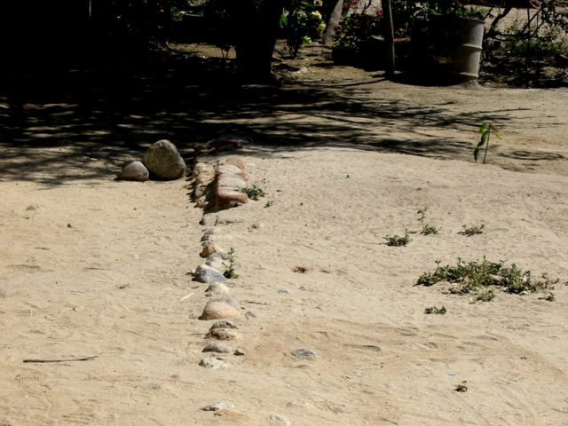
Native language. This was the start of Mission Santiago el Apóstol Aiñiní. The location was about 2 miles north of today's town of Santiago.
Foundation stones were visible 20 years ago at a ranch. Visitors were not welcome.
The mission was destroyed in the Pericú Revolt of 1734. When the revolt was over, the mission was reestablished where the town is today and a modern
church is built on that site.
Map makers and authors were not aware of the mission name change in 1724 and have continued to call it 'Santiago de los Coras'. Letters revealing the
change were not discovered until the 1970s.
Photos of the 1724-1734 location (by Jack Swords in 2003) followed by a photo of the 1736-1795 location (modern church from the 1950s), taken in 2017
by David Kier. Native place names map from https://www.sandiegoarchaeology.org/laylander/baja :


Airapí = La Paz; Marinó = first Santiago mission attempt; Aiñiní = new Santiago mission site; and Añuití = San José del Cabo
|
|
|
4x4abc
Ultra Nomad
    
Posts: 4283
Registered: 4-24-2009
Location: La Paz, BCS
Member Is Offline
Mood: happy - always
|
|
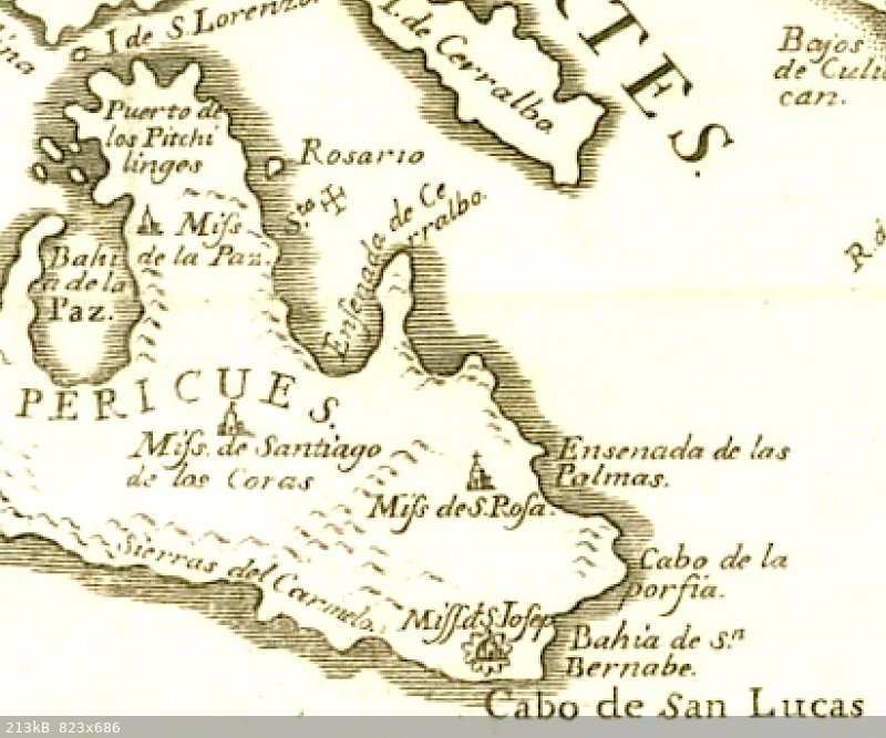
the 1757 map is pretty clear about the location of Ensenada de las Palmas
it is just a tad north of Cabo Pulmo
lotsa water and palm trees there (including date palms)
no date palms around Los Barriles
but since the location of Mision de las Rosas is wrong - you could argue that Ensenada de las Palmas is wrong as well

Harald Pietschmann
|
|
|
David K
Honored Nomad
        
Posts: 64790
Registered: 8-30-2002
Location: San Diego County
Member Is Offline
Mood: Have Baja Fever
|
|
Thanks Harald. Yes, the mission (Santa Rosa) was put on the wrong side of the peninsula.
The creator (Miguel Venegas) was on the mainland, and used letters to create the map contents. He knew of a visita of San José del Cabo mission named
Santa Rosa, so he assumed that was what became the new mission in 1733.
Santa Rosa mission was established at Todos Santos, a visita of the La Paz mission. When the La Paz mission moved from the bay to Todos Santos, that
ended Santa Rosa's existence, in 1748. The map is dated in 1757, but the details of the map, such as the one I just named, indicate the data used to
make are from 1747, or earlier.
Of course, since you have my book, you already know all of that stuff! 
|
|
|
David K
Honored Nomad
        
Posts: 64790
Registered: 8-30-2002
Location: San Diego County
Member Is Offline
Mood: Have Baja Fever
|
|
Miguel Venegas:
https://en.wikipedia.org/wiki/Miguel_Venegas
Andrés Marcos Burriel, who finalized the work in 1757:
https://en.wikipedia.org/wiki/Andr%C3%A9s_Marcos_Burriel
|
|
|
|

