David K
Honored Nomad

Posts: 64540
Registered: 8-30-2002
Location: San Diego County
Member Is Offline
Mood: Have Baja Fever
|
|
Fun with Maps! What do you see interesting on the 1971 map?
Serously trying to breathe some life into this forum!
This map is from the 1971 Sunset Baja Guide. It is quite good for a simple-to-read road map. Only one major error is on it. Can you find it?
ENJOY!!!

Here is the next sections going south (paving had reached north to Loreto):


|
|
|
David K
Honored Nomad
Posts: 64540
Registered: 8-30-2002
Location: San Diego County
Member Is Offline
Mood: Have Baja Fever
|
|
The Northern Region
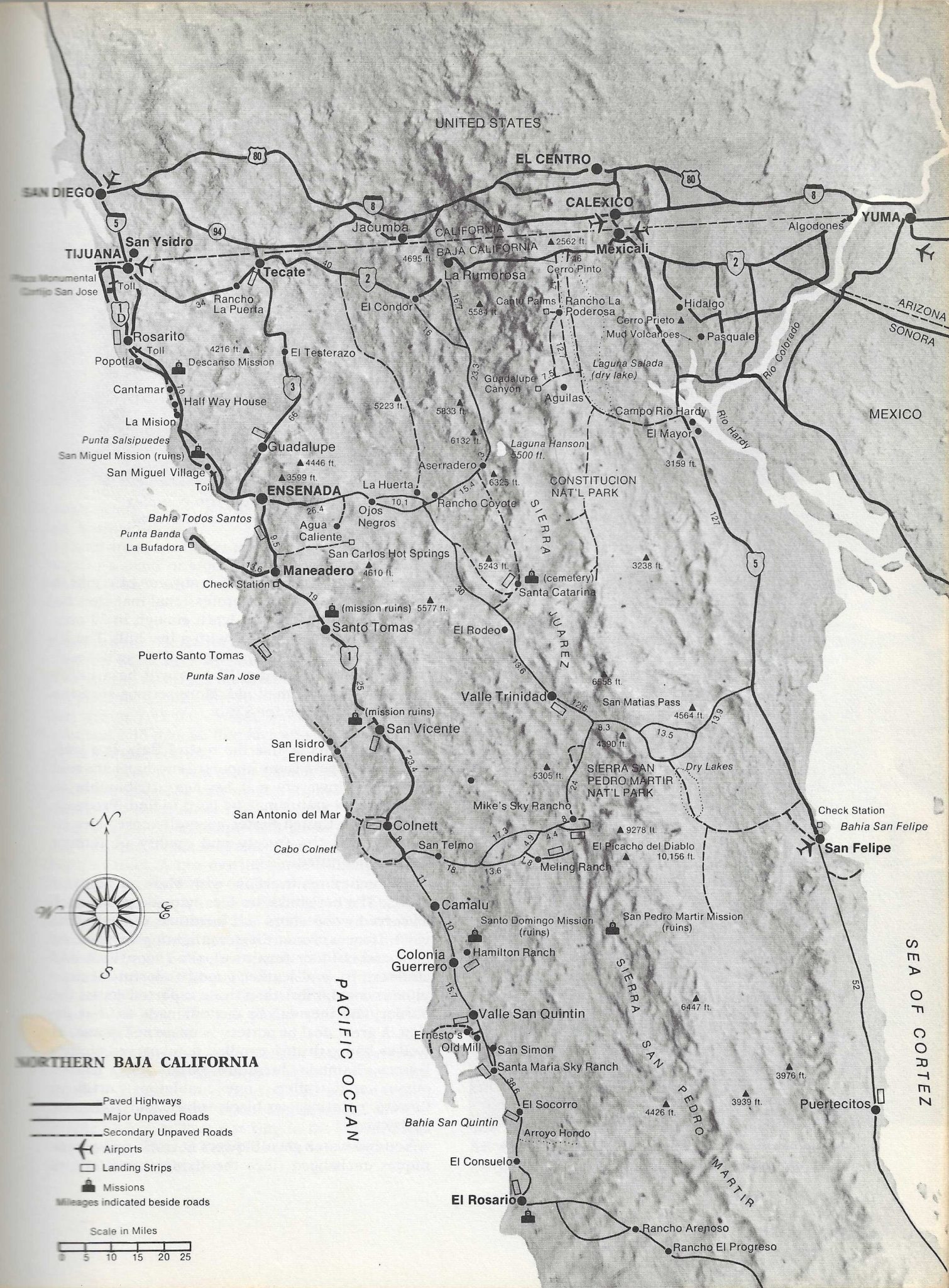
Pavement southbound from the border ended at the San Telmo junction (today's Observatory road) and San Felipe.
|
|
|
KurtG
Super Nomad
Posts: 1201
Registered: 1-27-2004
Location: California Central Coast
Member Is Offline
Mood: Press On Regardless!!
|
|
I just did a quick glance but two things jumped out at me. I have never seen the upper part of Bahia Concepcion called Laguna Santispac and El
Requeson is called Raquelson
|
|
|
David K
Honored Nomad
Posts: 64540
Registered: 8-30-2002
Location: San Diego County
Member Is Offline
Mood: Have Baja Fever
|
|
Quote: Originally posted by KurtG  | | I just did a quick glance but two things jumped out at me. I have never seen the upper part of Bahia Concepcion called Laguna Santispac and El
Requeson is called Raquelson |
The Requesón spelling is a good catch.
Santispac lagoon is okay, however. Is it not?
Check the border typo!
|
|
|
Biznaga
Newbie
Posts: 7
Registered: 8-28-2023
Member Is Offline
|
|
David,
it looks like the major typo they made on this map was labeling Baja California as a "TERRITORY" and Baja California Sur as a "STATE."
I'm pretty sure Baja California became a state way before B.C.S.
Didn't B.C.S. become a state around the time they finished paving Highway 1?
|
|
|
David K
Honored Nomad
Posts: 64540
Registered: 8-30-2002
Location: San Diego County
Member Is Offline
Mood: Have Baja Fever
|
|
| Quote: Originally posted by Biznaga | David,
it looks like the major typo they made on this map was labeling Baja California as a "TERRITORY" and Baja California Sur as a "STATE."
I'm pretty sure Baja California became a state way before B.C.S.
Didn't B.C.S. become a state around the time they finished paving Highway 1?
|
Bravo, sir.
The north territory became a state in 1952, and chose the name Baja California without Norte included.
The south territory gained statehood in 1974, just months following the completion of the highway that finally connected it with the rest of the
republic. Unfortunately, they were left with the only option of having Sur as part of their name.
Ever since, there were attempts to rename the new state to Sud California (Southern California) as the peninsula was the first land named California.
Mexico's California (Baja California) and America's California (Alta California) is similar to the issues with Macedonia, causing the new republic to
modify it's name over Greek Macedonians' protests.
|
|
|
bajaric
Senior Nomad
Posts: 610
Registered: 2-2-2015
Member Is Offline
|
|
Actually a pretty good map. The only thing that jumps out at me is on the bottom map of Northern Baja California they put "Constitucion Nat'l Park"
east of Laguna Hanson, out in the desert of the Laguna Salada. This error is present on other maps of the period and must have been passed along from
mapmaker to mapmaker though who copied who is subject to debate --
|
|
|
David K
Honored Nomad
Posts: 64540
Registered: 8-30-2002
Location: San Diego County
Member Is Offline
Mood: Have Baja Fever
|
|
| Quote: Originally posted by bajaric | | Actually a pretty good map. The only thing that jumps out at me is on the bottom map of Northern Baja California they put "Constitucion Nat'l Park"
east of Laguna Hanson, out in the desert of the Laguna Salada. This error is present on other maps of the period and must have been passed along from
mapmaker to mapmaker though who copied who is subject to debate -- |
Good eye!
I kind of think it was more a matter of room for the text: over the already name-filled sierra or out in the empty desert? LOL
|
|
|


