| Pages:
1
2 |
David K
Honored Nomad

Posts: 64549
Registered: 8-30-2002
Location: San Diego County
Member Is Offline
Mood: Have Baja Fever
|
|
Gracias B'Runner!
The 27 missions in Baja and their many visitas are a grand source for exploration, wonder, photography, reflection and so much more.
If we can keep the eyes open to this huge part of Baja's history and mystery, it could so benefit today's Baja population... If only they would stop
destroying this window to the past!
It is one thing to lose a mission to nature, as in the case of Ligui. It is another to lose one to indifference or something else, as in the case of
the farmer who plows over as site, or the government that bulldozes one to build a school on top of it... What does that teach?
|
|
|
thebajarunner
Ultra Nomad
Posts: 3687
Registered: 9-8-2003
Location: Arizona....."Free at last from crumbling Cali
Member Is Offline
Mood: muy amable
|
|
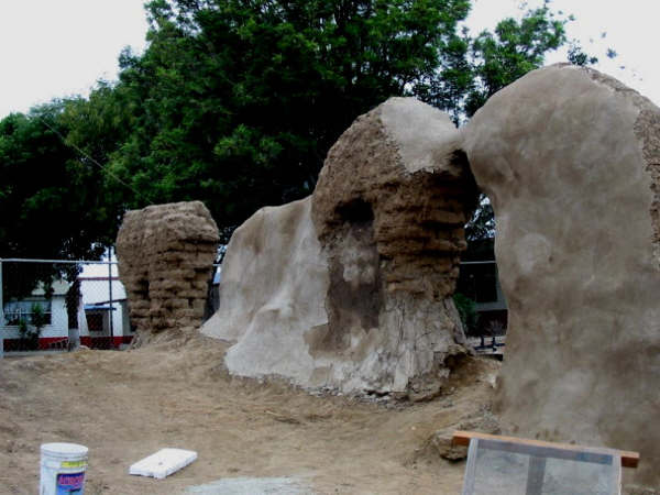
Your photos of the Santo Tomas decline bring back lots of memories
At least, in some sites, like San Borja, they have built covering metal canopies over the ruins to give some semblance of preservation.
We could only hope for a better way to memorialize the past.
I seem to remember similar decay of the ruins in La Mision.
|
|
|
David K
Honored Nomad
Posts: 64549
Registered: 8-30-2002
Location: San Diego County
Member Is Offline
Mood: Have Baja Fever
|
|
| Quote: | Originally posted by thebajarunner
I seem to remember similar decay of the ruins in La Mision. |
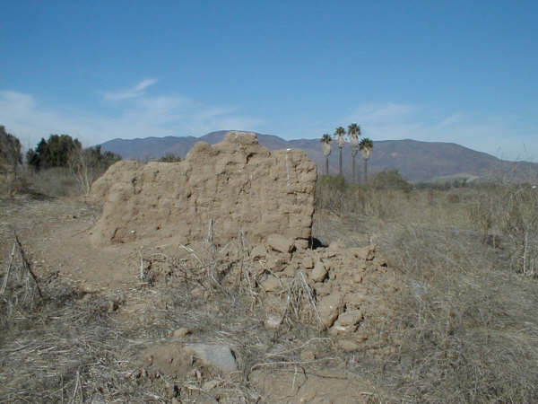
1949:
McDonald Photo
2003:
Jack Swords Photos
1926 plan by P. Meigs:

|
|
|
David K
Honored Nomad
Posts: 64549
Registered: 8-30-2002
Location: San Diego County
Member Is Offline
Mood: Have Baja Fever
|
|
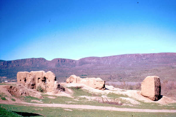
The final site of Santo Tomas... (1799-1849)...

In 1926

In 1975
In 2005
This is just north of the El Palomar campground, east side of Mex. 1, as you enter town. The tall palms are a landmark seen from the highway.
|
|
|
David K
Honored Nomad
Posts: 64549
Registered: 8-30-2002
Location: San Diego County
Member Is Offline
Mood: Have Baja Fever
|
|
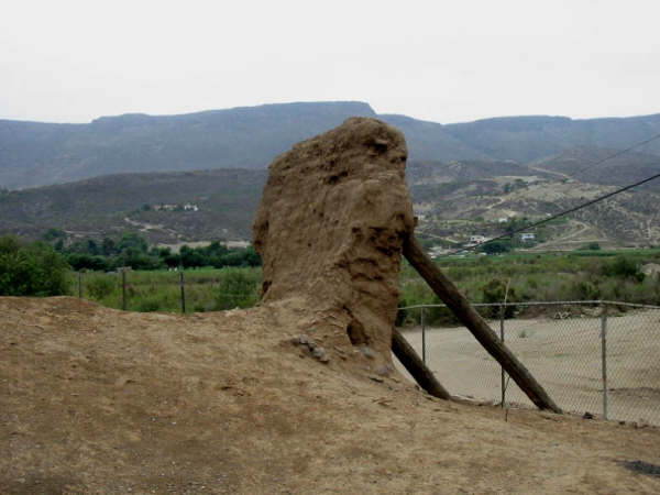
See them disappear...
Santo Domingo is 5 easy graded dirt miles east of Hwy. 1, just north of the long bridge before Colonia V. Guerrero...
The final site for the mission, 1793-1839
1880:

1926:

1949:

1954:

2003:

2005:

|
|
|
Mexitron
Ultra Nomad
Posts: 3397
Registered: 9-21-2003
Location: Fort Worth, Texas
Member Is Offline
Mood: Happy!
|
|
Cool pics, thanks David! BTW have you been back to the visita area out by R. El Metate recently to see what's become of the plowed field?
|
|
|
David K
Honored Nomad
Posts: 64549
Registered: 8-30-2002
Location: San Diego County
Member Is Offline
Mood: Have Baja Fever
|
|
No... haven't been there since the farmer destroyed the mission visita church from 230 years ago.
|
|
|
BajaRat
Super Nomad
Posts: 1302
Registered: 3-2-2010
Location: SW Four Corners / Bahia Asuncion BCS
Member Is Offline
Mood: Ready for some salt water with my Tecate
|
|
David,
Any site or thread discussing GPS puck / Google map setup and operation.
Thanks, BajaRat
|
|
|
David K
Honored Nomad
Posts: 64549
Registered: 8-30-2002
Location: San Diego County
Member Is Offline
Mood: Have Baja Fever
|
|
| Quote: | Originally posted by BajaRat
David,
Any site or thread discussing GPS puck / Google map setup and operation.
Thanks, BajaRat |
Help me please... what is GPS puck ? On my Baja Missions pages I have GPS waypoints and Google Earth images above the mission sites... HERE: http://vivabaja.com/missions4/
[Edited on 4-15-2012 by David K]
|
|
|
BajaRat
Super Nomad
Posts: 1302
Registered: 3-2-2010
Location: SW Four Corners / Bahia Asuncion BCS
Member Is Offline
Mood: Ready for some salt water with my Tecate
|
|
David,
It is a sat. antenna you plug in to your computer to plot and place you on a Google map.
|
|
|
David K
Honored Nomad
Posts: 64549
Registered: 8-30-2002
Location: San Diego County
Member Is Offline
Mood: Have Baja Fever
|
|
| Quote: | Originally posted by BajaRat
David,
It is a sat. antenna you plug in to your computer to plot and place you on a Google map. |
Sounds like I need one of those... if I ever get a lap top!
I would try the Google Earth forums for discussion on that set up... Unless some Nomads see this here, who have it.
|
|
|
BajaRat
Super Nomad
Posts: 1302
Registered: 3-2-2010
Location: SW Four Corners / Bahia Asuncion BCS
Member Is Offline
Mood: Ready for some salt water with my Tecate
|
|
I'm wondering if a tablet would have the same capability, less space, energy, ease of handling.
|
|
|
Jack Swords
Super Nomad
Posts: 1094
Registered: 8-30-2002
Location: Nipomo, CA/La Paz, BCS
Member Is Offline
|
|
http://www.amazon.com/GlobalSat-BU-353-Waterproof-USB-Receiv...
Have been using this GPS and my netbook in the Mojave Desert. It is necessary to cache an intended area in Google Earth before using it in the area.
It works well just with GE, but better with Earthbridge software (free). It will leave a track (both GE and EB) that you can review later. I plan on
using it in the area between La Paz and Constitucion and the Sea of Cortez. It also will work with the TOPO products (which recently came out with a
TOPO CD of Baja). There is also a Bluetooth version (the other is USB) that will work with Ipad, Touch, netbooks, etc. as long as it has Bluetooth.
This version is about $100, but is wireless. The linked one (about $35) is quite fast in acquiring satellites (faster than my handheld GPSs) and has
a magnet for the rooftop, but works as well on the dash. Many, many topographical programs are available on the internet to load into GE and enhance
what you view. The learning curve is steep, for me anyway, but wow! what a tool for Baja (and the Mojave). The tablets do not have a GPS that
measures up in comparison, have personal experience with that. Another issue is the shiny screen in the daylight. GE will work by itself and show a
track, but more options are available with EB or Goops and GE.
These are actually full GPS units, not an antenna. USB powers the linked one, a small battery powers the Bluetooth version. (edited to add this)
[Edited on 15-4-2012 by Jack Swords]
|
|
|
windgrrl
Super Nomad
Posts: 1323
Registered: 9-2-2006
Member Is Offline
|
|
Thanks for this post - got hooked on Baja missions this year!
When the way comes to an end, then change. Having changed, you pass through.
~ I-Ching
|
|
|
David K
Honored Nomad
Posts: 64549
Registered: 8-30-2002
Location: San Diego County
Member Is Offline
Mood: Have Baja Fever
|
|
| Quote: | Originally posted by windgrrl
Thanks for this post - got hooked on Baja missions this year!
|
Please enjoy the several pages of mission and visita data, photos, locations, etc. at http://vivabaja.com/bajamissions
I recommend you get one or two books published recently to further your mission quest for knowledge!
1) Las Misiones Antiguas: The Spanish Missions of Baja California by Edward W. Vernon c2002
http://www.bajacaliforniamissions.com/pages/missions.html
2) Saints and Demons in a Desert Wilderness: A History and Guide to Baja California's Spanish Missions byDave Werschkul c2003
Saints and Demons on Amazon.com
|
|
|
David K
Honored Nomad
Posts: 64549
Registered: 8-30-2002
Location: San Diego County
Member Is Offline
Mood: Have Baja Fever
|
|
In the thread on San Gabriel mission in Non-Baja Trip Reports, I was asked if all the Baja missions were located...
Yes, and the maps above give a general location, with exact locations on my Baja Missions web pages.
Nearly half of all the missions were moved to better locations after they were founded... usuall for better water supply or food growing conditions.
A mission had an official name that usually included the local tribe's name for the location: Nuestra Señora de Loreto Conchó for example (Conchó
being the native's name for the location).
Often a mission would be called by the previous pre-mission site name: La Pasion for Los Dolores new site, and Todos Santos for Santa Rosa and later
La Paz... the two missions that were established at Todos Santos (which was originally a visita for La Paz).
North of San Ignacio, finding water supplies suitable for a mission was difficult. The next mission to the north was planned to be called Dolores del
Norte and Padre Consag even baptized neophytes into Dolores del Norte, long before it had funds to be built. Consag found water at a site he called La
Piedad and with the 1748 closing of San Jose del Cabo, its funds could be used for the next mission. However, the benefactor requested the mission be
called Santa Gertrudis. Maps and lists containg 'Dolores del Norte' have caused many to seek a lost mission by that name.
|
|
|
| Pages:
1
2 |


