| Pages:
1
2 |
Arthur
Nomad

Posts: 232
Registered: 10-2-2003
Location: San Anselmo, CA
Member Is Offline
|
|
Valle Chico Trip, March 2005
Author?s note: In typing up these pages, which I composed daily while were on our trip, I can?t avoid being painfully aware of how comical ? or even
frustrating ? the details of our sometimes-confused wanderings could be to someone who knows this territory well, or has approached it with a GPS or a
knowledgeable friend. Let me assure one and all, however, that while we now wish we?d had a GPS, and had not taken an early shortcut, and had relied
more on David K?s hand-drawn map, we were fully prepared for a week in the desert, and the desert is where we wanted to be. I think everyone who has
been down that way can understand that I would rather be down there living those days again than doing virtually anything that I can think of up here.
And I will be taking that shortcut again.
Friday, 3/25/05
Left Oakland around 7 am, drove straight through. Found ourselves outside El Centro about 12 hours later ? running out of gas, the Check Engine light
glowing, and the freeway exit for Holtville (where Nomad Bufeo had recommended a hotel) closed. Kept heading east, took the next exit, and turned
north toward El Centro, rolling along aimlessly through the rapidly darkening farmland, tempted to head for any light that we could see. Suddenly the
giant orange orb of the moon appeared over the eastern horizon. It was a beautiful sight, with the sky somehow still blue and the fields glowing a
deep green. Shortly thereafter we rolled right into Holtville, found a gas station, and got directions to the Barbara Worth Resort.
The place is truly an oasis, with giant trees that I?ll bet are over 100 years old looming over the parking lot and surrounded by farmland and a golf
course. A $20 seafood buffet was laid out in the dining room, and we made good use of it. The engine looked (and sounded) fine when I looked under the
hood, so we decided not to look for a mechanic with a code reader.
Saturday, 3/26/05
Got a leisurely start and headed out a farm road to Highway 98 and the east Calexico border crossing. Spent too long searching for good rum in
Mexicali; saw no Flor de Cana or the standard (yellow-label) Havana Club that we enjoyed so much in Loreto. Settled for a couple 750?s of the dark
Havana Club Anejo ? a fine thing to have along in any case ? and a liter of Appleton?s to keep in reserve. Hit lots of returning Easter traffic on the
two-lane road south to San Felipe, entered the Sierra San Pedro de Martir around 4:30 and took the shortcut off the East Valley Road that connects to
the West Valley Road north of Canyon El Cajon. Thought we had gotten as far as Canyon Agua Caliente, but couldn?t reconcile either the Almanac or
David K?s maps with the features on the ground ? and we didn?t have a GPS. Checked out El Cajon (which involves a tough climb out of a streambed
before the road ends anyway) and Canyon Barroso (which looked in our headlights like it had a dwelling at the canyon mouth), then made a dry camp on a
side road that dead-ended against the mountains south of El Cajon. It was beautiful, of course: Lots of ocotillo, and a view of the Sierra San Pedro
de Martir to the west and the Sierra San Felipe to the east.
Sunday, 3/27/05
Woke to a beautiful red-and-orange banded sunrise over the Sierra San Felipe, while the Sierra San Pedro de Martir to the west glowed red. Broke camp
and headed south to take another shot at finding Canyon Agua Caliente and the spot where the East Valley Road comes in. Looked in vain for landmarks;
as it turned out, our shortcut had put us onto the West Valley Road way short of where we thought we were. Couldn?t find anything resembling the Plan
Agricultural, but located a settlement that we thought must mark Canyon Agua Caliente. No idea of how to get up into the canyon by road, which David K
had done last year. No wonder ? we figured out later that we were at Algodon. Headed north, missed the sand track to Canyon Barroso that we had taken
last night, and found Canyon El Cajon again.
Talked to a Mexican family out for a Sunday outing and confirmed the name of the canyon. They also showed us pictographs on the underside of a large
overhanging rock just down from a large metal tank that supplied some settlement downstream but was also set up for swimming. Finally we know where we
were. Parked just before the stream crossing and walked way up into the canyon beyond the dam, to where the stream does a radical ?S,? almost doubling
back on itself. Returned to a shady, rocky spot well above the dam which has a small waterfall and lots of granite-colored frogs crouched in cracks in
the rock. Took a good bath, and reveled in the water. Hiked back out to the truck and drove south. Didn?t see any other canyons, but found the track
to Canyon Barroso, which has an intricate ocotillo fence and a flow that stopped at about that point. No human habitation. In the middle of a
tumbledown corral, someone had impaled a worn-out washtub on a post. As Dick said, in the US it wold be full of bullet holes.
Camped near the wash ? below where the water stopped, but close enough. A small wet strip at the center of the wash marked where the stream coming out
of the canyon recently ran. In the stillness after dark -- the whole area was amazingly still -- we could hear the water flowing 150 yards up the
canyon near the ocotillo fence. A warmer night than the night before; a ring around the moon. We felt like people must have felt camping in the US
before campgrounds and all the junk that goes with them had been created.
Monday, 3/28/05
Awoke to an overcast day, a muted sunrise. More bird noises now. Hung our small cooler from a tree in the wash and draped wet towels over it to make
an improvised swamp cooler. Our rum and fruit juice bob in a collapsible French army-surplus water bucket, which keeps things surprisingly cold. No
cold beer and no ice cubes on this trip. To our surprise, there was a thin band of water flowing all the way down the wash and out of sight. Did it
rain somewhere? Is this snowmelt from yesterday? Should we be camping this close to the wash?
Canyon Barroso can be identified by wide horizontal bands of white granite on two pyramidal peaks set back between the slanting walls that form the
mouth of the canyon. These markers disappear for awhile when you start hiking up the canyon, but the rock you?re walking on offers quite a jumble of
bands and dikes of differing material with water cascading and pooling over them, broad granite slabs stained with rust, and sprinklings of mica and
garnet here and there. We saw the same thin white dikes in Canyon Agua Caliente, where, as David K has noted, one swoops down into the canyon to point
directly to the hot springs. Few cows had made it past the elaborate fence, but several of them had never made it back out again. Fortunately, they
were, by and large, pretty dried out and eviscerated, and none of them were lying directly in the water.
Once again we walked a long way up into the canyon. When we finally decided to turn around, we had our pick of beautiful places to bathe, although
shade was hard to find. When we returned to camp the little creek in the middle of the wash was running well, but in fact it was already receding, and
as the sun went down we saw that it was now underground again from the point where the fence went across the mouth of the canyon.
The overcast that had made hiking quite comfortable burned off late in the day, and I walked back up the canyon to improve a little pool that I had
noticed. There was also shade on the sand bank nearby, so I had my choice of reading in the shade or sitting in the pool up against a little waterfall
and gazing down the wash all the way to the Sierra San Felipe. Several hummingbirds came around, and there were many varieties of desert wildflowers.
No one had come up the road since we arrived the day before. Life is good.
Copyright 2005 by Arthur Comings
(To be continued)
[Edited on 5-3-2005 by Arthur]
|
|
|
David K
Honored Nomad
Posts: 64490
Registered: 8-30-2002
Location: San Diego County
Member Is Offline
Mood: Have Baja Fever
|
|
Baja is a magic place, 'eh Arthur?
My map, or any is only designed to tease you enough to explore and make your own discoveries. No number of photos or GPS waypoints can rob anyone of
making new discoveries of their own. Baja California is far too special to be so easily revealed.
Thanks for sharing your travels with your amigos here!
|
|
|
David K
Honored Nomad
Posts: 64490
Registered: 8-30-2002
Location: San Diego County
Member Is Offline
Mood: Have Baja Fever
|
|
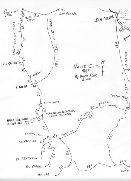
Here is the map, if it helps to follow Arthur's trip report with...
Barroso canyon is between El Cajon and Algodon...
|
|
|
Arthur
Nomad
Posts: 232
Registered: 10-2-2003
Location: San Anselmo, CA
Member Is Offline
|
|
Thanks for posting the map, David. That's the very one that we came to rely on heavily. Barroso is the first canyon south of El Cajon. We also went up
into the next one, Novillo.
The shortcut that I mention extends from about the "T" in "East Valley Road" southwest to the "3.4" on West Valley Road on David's map.
If you redraw that map, David, maybe you can put in the shortcut. I actually prefer it to taking the East Valley Road the whole way. We got into some
pretty big sand dunes on that road as we headed home.
|
|
|
David K
Honored Nomad
Posts: 64490
Registered: 8-30-2002
Location: San Diego County
Member Is Offline
Mood: Have Baja Fever
|
|
Thanks Artrhur, I suspected that one or both roads going east, off the 'west valley road' (north of El Cajon) did cross over to the 'east valley
road'... at a point about 6.8 or 6.9 miles south of the original Ensenada- San Felipe road, at the top of the map. I show the east end of it on my
other maps, but didn't include the junction on this one because I didn't travel it last year or mention it in my trip report on the Exotic Canyons...
The east valley road has always been super fast, graded road from near Algodon all the way to Hwy. 5... surprised you found so much drift sand on it!
[Edited on 4-29-2005 by David K]
|
|
|
Arthur
Nomad
Posts: 232
Registered: 10-2-2003
Location: San Anselmo, CA
Member Is Offline
|
|
It was the kind of place where (with the 2WD Prerunner) I just keep my speed up and hope that my momentum and whatever the rear wheels can contribute
will carry me through. I didn't even care for the road north of the sandy spots (which were right by a working ranch, if that places them for you).
There was plenty of washboarding, and you're out in the open, between the two ranges. On the West Valley Road you're close up to that range, and the
"shortcut," when it comes, is a nice, hard-packed "unimproved" desert track.
|
|
|
David K
Honored Nomad
Posts: 64490
Registered: 8-30-2002
Location: San Diego County
Member Is Offline
Mood: Have Baja Fever
|
|
Here's (part of) my map from several years ago, and it shows that short cut junction... there was a sign then labled 'El Cajon'...
I cut it to just the valley, so it was small enough top post here, and still see details...
[Edited on 4-29-2005 by David K]
|
|
|
Mike Humfreville
Super Nomad
Posts: 1148
Registered: 8-26-2003
Member Is Offline
|
|
Good stuff...
Looking forward to a continuing thread. That's barren country. Several of us tried to get up to another canyon, Matomi, via different route using
David's maps. The maps were correct, but the road was horrible and we turned back because my pal hadn't filled his gas tank. Was I whizzed? You
bet!
Glad you had fun and looking forward to the next segment.
|
|
|
bajalou
Ultra Nomad
Posts: 4459
Registered: 3-11-2004
Location: South of the broder
Member Is Offline
|
|
A couple coments - on your second (older map) what we call Cross Valley Rd is the one you show going to rancho El Cajon, It continues straight past
hitting West Valley rd just north of the turn to Canon El Cajon. I drove across the sand Arthur was talking about one windy afternoon and returned 30
min later and had to find the road all over again. Where there's any sand, the wind can change things in nothing flat.
There is another road across the valley, just S of the cattlegard on East Valley rd. about where the "12.5" is. Heads straight west past a ranch
now housing a drug and alcohol rehab.
All this gives me the reasons you are so excited about here. As I have been for quite a while.

No Bad Days
\"Never argue with an idiot. People watching may not be able to tell the difference\"
\"The trouble with doing nothing is - how do I know when I\'m done?\"
Nomad Baja Interactive map
And in the San Felipe area - check out Valle Chico area |
|
|
Neal Johns
Super Nomad
Posts: 1687
Registered: 10-31-2002
Location: Lytle Creek, CA
Member Is Offline
Mood: In love!
|
|
Arthur, Now you are a REAL Nomad. Girliemen don't get semi-lost! 
My motto:
Never let a Dragon pass by without pulling its tail!
|
|
|
Arthur
Nomad
Posts: 232
Registered: 10-2-2003
Location: San Anselmo, CA
Member Is Offline
|
|
We checked out that other road, Lou, but coming from the West Valley Road. It runs right along a fenceline that we thought for awhile must be the
fenceline that appears to the south on David's map. Soon after you leave the West Valley Road, there's an abandoned spread to the north consisting of
a plywood house and a water tank. It's kinda sad to see these places and to imagine all the hard work and dreams that went into them before people
finally gave up the fight.
Lou, it looks like we'll be in town (my son and I) the long weekend starting May 13th. Are you going to be at the flea market? How can we tell who
you are?
|
|
|
bajalou
Ultra Nomad
Posts: 4459
Registered: 3-11-2004
Location: South of the broder
Member Is Offline
|
|
I'll be here on the 13th and maybe the 14th, if so, I'll be at the flea market at around 730-8am. By 830 it's kind of shutting down. Email me and
maybe we can set something up for Fri evening? I'll be out of town from the 15th thru 18th.
No Bad Days
\"Never argue with an idiot. People watching may not be able to tell the difference\"
\"The trouble with doing nothing is - how do I know when I\'m done?\"
Nomad Baja Interactive map
And in the San Felipe area - check out Valle Chico area |
|
|
bajalou
Ultra Nomad
Posts: 4459
Registered: 3-11-2004
Location: South of the broder
Member Is Offline
|
|
And let's hear about the rest of your Valle Chico trip.
No Bad Days
\"Never argue with an idiot. People watching may not be able to tell the difference\"
\"The trouble with doing nothing is - how do I know when I\'m done?\"
Nomad Baja Interactive map
And in the San Felipe area - check out Valle Chico area |
|
|
David K
Honored Nomad
Posts: 64490
Registered: 8-30-2002
Location: San Diego County
Member Is Offline
Mood: Have Baja Fever
|
|
Here's slightly more recent photo of BajaLou!

|
|
|
meme
Senior Nomad
Posts: 756
Registered: 8-20-2003
Location: San Felipe,BC
Member Is Offline
|
|
LOU! IS there still a Flea Market going on in May? We thought it was finished for the season the end of April?
|
|
|
bajalou
Ultra Nomad
Posts: 4459
Registered: 3-11-2004
Location: South of the broder
Member Is Offline
|
|
Meme - heard from a couple people it'll go till Memorial day. Time will tell I expect.
No Bad Days
\"Never argue with an idiot. People watching may not be able to tell the difference\"
\"The trouble with doing nothing is - how do I know when I\'m done?\"
Nomad Baja Interactive map
And in the San Felipe area - check out Valle Chico area |
|
|
Arthur
Nomad
Posts: 232
Registered: 10-2-2003
Location: San Anselmo, CA
Member Is Offline
|
|
Now, that is some kind of early-closing flea market!
|
|
|
bajalou
Ultra Nomad
Posts: 4459
Registered: 3-11-2004
Location: South of the broder
Member Is Offline
|
|
The valle
Here is a shot of the roads we've been talking about with the road into Agua Caliente the longest line heading west (left) near the bottom of the
picture.
The track which apears to be a southern extension of East Valle Rd is a race road - not for usual traffic.
The very short line near the center (heading west) is to the corral in El Cajon.
The lines heading E and NE are thru canyons not used for everyday traffic and not for 2WD.
No Bad Days
\"Never argue with an idiot. People watching may not be able to tell the difference\"
\"The trouble with doing nothing is - how do I know when I\'m done?\"
Nomad Baja Interactive map
And in the San Felipe area - check out Valle Chico area |
|
|
burro bob
Nomad
Posts: 264
Registered: 3-15-2004
Location: Poblado del Ejido Plan National Agrario
Member Is Offline
|
|
Arthur
When you were here in Cajon----
|
|
|
burro bob
Nomad
Posts: 264
Registered: 3-15-2004
Location: Poblado del Ejido Plan National Agrario
Member Is Offline
|
|
You were less than 100 yards from these finger paintings. This is a small part of the pinturas on this rock.
You were only half way to the "Pato de Gallo" where a the three branches of Cajon come togeather.
Sounds like you had a great trip. Canyon Cajon is easy to find, most everybody ends up there when they go south at Morelia junction, into the
mountains.
burro bob
|
|
|
| Pages:
1
2 |