| Pages:
1
2
3 |
Geothermal-Shane
Junior Nomad

Posts: 83
Registered: 5-14-2005
Member Is Offline
|
|
El Carrizo Canyon(Sierra Juarez)
Does anybody have infomation regarding a hot spring in the next canyon north from Guadalupe Canyon?
Rumor has it, "El Carrizo" shown in the Baja Almanac is a hot spring/palm oasis.
also...
Does anybody have information regarding a hot spring at Agua Caliente in Canada de la Parra/Canada Jamin in the
southeast Sierra Juarez? (also shown in the Baja Almanac)
|
|
|
David K
Honored Nomad
Posts: 65565
Registered: 8-30-2002
Location: San Diego County
Member Is Offline
Mood: Have Baja Fever
|
|
Agua Caliente in the Sierra Juarez
Neal Johns and also Baja Nomad member 'bajataco' has been there... Here is the link to his 2000 trip photos... http://www.bajataco.com/Baja/bajamap.html it is a map of Baja with a clickable dot in various places. Click the dot(s) on the Sierra Juarez... the
lowest one tells about the drive to Agua Caliente... Bajataco has photos of the oasis there, but on another page.
From his post on Nomad at: http://forums.bajanomad.com/viewthread.php?tid=8971#pid66467
Also:
[Edited on 5-15-2005 by David K]
|
|
|
Geothermal-Shane
Junior Nomad
Posts: 83
Registered: 5-14-2005
Member Is Offline
|
|
Thanks alot David K, this is useful information.
My understanding is that this location is accessible from the El Mano grade-Laguna Salada road, by turning south at the junction
N 31.47.680' W115.36.650'
This looks and sounds like a very remote location...
I'll be heading to Guadalupe Canyon on June 15 and am hoping to explore some of the other canyons in the East Sierra Juarez, namely Palomar and the
alleged El Carrizo for their remote hot springs. It would be nice to include the Agua Caliente pictured above, but June temperatures may sabotage
morale once some 80 miles from the neareast paved road. But maybe we need some of that, so we'll see what happens.
Last June I had recently bought a 1988 Mitsubishi Montero(two door with 192,000 on the clock) and so for its christening we headed down into Laguna
Salada in a fleeted attempt to find Palomar Canyon hot springs.
"Hot Springs and Hot Pools of the Southwest" got us into the ultimate boggle. After getting lost near Pozo Salada, we managed to find the main graded
dirt road running N-S through the valley, and made the first major right turn south of the Guadalupe Canyon road. We drove south some 10 miles to a
narrow junction with an A-shaped pickett. From there we followed the junction road about a mile to a fully stocked ranch that was currently
unoccupied, then down into a very sandy wash past a lone palm tree* and up into a boulder field briefly before popping our first tire. Considering
that it was 110 degrees, we took a minute to calm down. Neither one of us had ever even changed a tire! All proved a valuable learning experienced
when we jacked up the small jeep, only to see the jack sink in the deep sand. We instead dug out from under the tire whilst the jack provided a mere
inch of clearance and made the swap quickly.
Throroughly wigged out, we decided to abandon our exploration and retreat to Guadalupe with out a spare. Two days later, en route from Guadalupe to
Mexicali, we popped another tire on the washboard 11 miles south of Hwy 2. Now the situation could be fully appreciated! We sat in the jail cell of
our jeep's shade waiting for the sun to drop over the Sierra Juarez, and not a car passed. It felt like our metabolisms had stopped. Furthermore, our
dwindling water supply of less than two gallons was already above 100 degrees and all of our ice and dry ice had long since melted. Desperate? The
possibility of walking out to the hiway was not an option, but La Ponderosa was, as we had passed it about twenty minutes before the second flat. Once
the sun was down, we walked back south in the eerie twilight warmth, finally- a Ford Bronco! It was a local who dropped us off at La Ponderosa, but
could offer no more help. Now we were at the mercy of an old leather-faced rancher. Here's where Japanese cars don't pay off in Baja- all his tires
were mounted on rims with five bolts(ours six).
We figured on walking back to our car, then walking our flat tire back to the ranch and then swaping rims. The walk back to the jeep was long, dark
and hot, but culminated in the passing of another car- a brand new Montero-load full of San Diegans eager to help us. But the swap was just not
possible by hand. They left us back at the jeep and said they'd come back for us in the morning. Then we'd go into Mexicali for a spare.
Next morning, no sign of anybody and even worse no shade anywhere, except under some vicious Sonoran thorn bush. Then of all things a swarm of wild
bees discovered us and our gallon of water. My Guatemalan girlfriend was stung. Now we were really desperate. After a few more bruised baking hours a
rattly Tacoma came down the road- a gay couple from San Diego who took us to the nearest llantera and that was that.
Upon the first sighting of an Oxxo it was like we had never seen ice before, and cold Tecate? It was like holy water!
sorry, didn't mean to ramble...thanks again
PS after that we went to Puertecitos and then Valle Chico for more grueling adventures in the sweltering heat, but never popped a tire the rest of
trip.
[Edited on 5-15-2005 by Geothermal-Shane]
[Edited on 5-15-2005 by Geothermal-Shane]
[Edited on 5-15-2005 by Geothermal-Shane]
|
|
|
David K
Honored Nomad
Posts: 65565
Registered: 8-30-2002
Location: San Diego County
Member Is Offline
Mood: Have Baja Fever
|
|
Awesome trip report Shane! THIS is what makes Baja Nomad awesome as a source for Baja travel and exploration information... Thank YOU!
Welcome to Baja Nomad... Please keep writing about your trips...
Next time, use the dry lake road instead of the washboard road between Hwy. 2 and Guadalupe Canyon. Going north, the junction is marked by a sign that
says 'Mexicali'. It reaches Mex. 2 about 2 1/2 miles east of the graded road's junction... Signed 'Laguna Salada' on Mex. 2.
OH, you might enjoy my web page on the Valle Chico/San Pedro Martir canyons... including the 'other' Agua Caliente hot springs: http://VIVABAJA.COM/404

[Edited on 5-16-2005 by David K]
|
|
|
Geothermal-Shane
Junior Nomad
Posts: 83
Registered: 5-14-2005
Member Is Offline
|
|
Actually, on that particular trip I did take the dry lake road on the drive in, but for some reason opted for the washboard on the way out. I remember
on the way accross the lake we hit an unexpected washout at 55mph- I had ten gallons of gas rigged to a surfboard roof rack that went flying apart.
One of the jerries came through the driver's window and slammed into my shoulder, good thing the window was open, though, or I may have gotten a face
full of glass. After those few days, I ultimately grew accustomed to a slower pace of Baja travel...
Before leaving on this trip I searched the internet for information regarding Agua Caliente in Valle Chico, and discovered VIVA BAJA. It was then that
I realized the vast possibilities in Valle Chico, which before was no more significant than an undeveloped hot spring in "some canyon" according to
Hot Springs and Hot Pools of the Southwest. I printed out a copy of the Valle Chico map. A few weeks later I found myself turning west at the Dos
Equis crocodile outside San Felipe. I had originally planned to make the trip into the valley with another vehicle, but it turned out the driver was
apprehended before leaving Temple City and held for 72 hours- for possesing a baton(?). His truck was fully loaded with camping gear and he was
getting on the 10 West headed for San Felipe. We decided to head out alone after waiting the agreed wait-period for this no show. The drive into Valle
Chico grew intense, bearing in our minds what had happened in Laguna Salada, and no amount of Tecate could relieve the situation. Thanks to the David
K map we didn't get lost, but we did bottom out on our front skid plate numerous times heading up the road into Agua Caliente canyon. Many large
boulders. Eventually we stopped at the base of a particularly nasty pitch where there was a place to turn around and made camp ahi. The temperature
was still about 110, so we waited for partial shade in the canyon before continuing up, at about 6:30 pm. We hiked maybe a mile and a half further
into the canyon to where there was no longer a road and then another mile or so through some very confusing terrain to a small hot waterfall that
jetted out of the brush into some algaeic muck and then back into the brush. Although we wanted to find the source we were more concerned with finding
our way back down to the end of the road with our cheap flashlights. It was starting to get dark, so our stay was brief. Before entering the valley we
had visited the Puertecitos hot tide pools and I badly injured my feet on the sharp rocks, and so took this brief moment in that big endless canyon to
heal my wounds in the scalding water. It was bearable for a while, actually quite soothing and numbing. The little waterfall was about 115 degrees. I
understand the source to be 144.
The hike back down probably speaks for itself. The blackened Baja night sky speckled with the usual stars. Once again the eerie night warmth gripped
us dressed in t-shirt, shorts and sombrero. Sweating down the canyon from one thornbush to the next, then wandering a few thornbushes too far and
backtracking. I think I remember seeing my tracks from the hike up in a few sandy spots, but the rest was just a matter of "well, which thornbush to
go plunging into now?" It was really a maze! Surrounded in all that big darkness with clawing gigantic thorn-beasts grappling us at every step,
looming up high as endless as the canyon walls above...and the great endless dark hole our backs are turned to leading god knows where...
By the time we got back to San Felipe we were thoroughly scathed with the indelable brand of Agua Caliente canyon.
We had hoped to go to Matomi, but opted to find a good hot spring to heal the cuts and scratches, and eventually ended up at "Russian Valley" in
another Agua Caliente canyon outside Valle Guadalupe, where the cows kept us company all day and all night. Here a shallow pool provided a whiplash
strength soak at 109 degrees in the morning/evening to 111 and hotter in the daytime.
I hope to make it to Matomi and perhaps Parral and even Agua Caliente again this June, if everyithing goes well in Laguna Salada/Sierra Juarez.
The Mitsubishi has been replaced by a 1983 Toyota Land Cruiser(FJ60) that wants to go to Baja badly.
|
|
|
Neal Johns
Super Nomad
Posts: 1687
Registered: 10-31-2002
Location: Lytle Creek, CA
Member Is Offline
Mood: In love!
|
|
Where you got your first flat is one canyon north of Palomar. For a few years there was a scarecrow at the driveway entrance and a Keep Out sign in
English/Spanish. Not sure of the real name, I call it Lone Palm Canyon. There are
some minor petros up canyon past the driveable part. There are
some minor petros up canyon past the driveable part.
Entering Palomar Canyon, a half mile or so past the palm log corral the road splits, take the left fork (the right fork goes into the very rocky
stream bed for a while and joins the other). In a few miles you will come to a palm grove with a house (Rancho Palomar - usually deserted) in it. The
cold spring there makes the main track very mucky. Careful! Continue past the house until the road ends in about a mile and a half. Over the edge is
a concreted empty pool. The hot spring is a couple of hundred feet upstream on the right bank with two concrete pools probable full of palm fronds and
muck.
The junction at N 31.47.680' W115.36.650' is hard to see. I recommend continuing south from the El Mano turnoff and then west as follows:
0 Start at main road right (west) to Canyon Guadalupe Hot Springs at intersection with washboard road to Hwy. 2.
6 Turn left, east. (right (straight) goes to Canyon Isabel and Palomar), very scenic.
8+ "T" turn right toward deserted Ejido Guardines de la Patria.
9.8. Pass Ejido Guardines de la Patria.
XX Ignore any roads left or right.
24.2 Ignore road right (to Canyons Isabel and Palomar).
25.4 Cajabuzo Junction-continue south (road east across large wash goes to Hwy 5).
28.3 Ignore road coming in over right shoulder (from Canyon Isabel).
Continue south, follow your nose to next checkpoint at 34.2, keep left if in doubt. Just don't get sucked off right, east, to Canyon El Mano. If you
want to go to El Mano, shortly before Mile 34.2 that road starts west on the south side of a small butte just after crossing a wash. After the El Mano
road turns right, west, there is a fence on the right side of road.
34.2 Cross opening in fence line (Major ?Am I Lost?? checkpoint). Continue south, a hair left, and in about 0.4 miles, climb up onto 10 foot mesa, and
follow hard surface two-track south. If you miss the road onto the mesa, it is probably to your left. (Don?t ask me how I know).
38.8 Stop! Campo la Victoria intersection ? 31 deg 45.6 min, 115 deg 33.5 min. ClV is an old mining camp/foundation east five or six miles across
several washes. You will not go there.
Look to the right and slightly ahead toward the west side of the valley and note a major canyon a couple of miles away. That is your
objective (Canada la Parra). Take the road south/a little west toward it that starts about a hundred feet north before the main road angles down,
left, off of "mesa" to go east across washes five or six miles to Campo la Victoria (where you don't want to go right now).
~41 Ignore road left that goes to bottom of El Mano.
~41+ Enter Canada la Parra and continue up it. Ignore tracks that bear left across wash (they go south along edge of mountains to Canon el Alamito).
~42+ Cross over a mini-summit (31 deg. 42.48 min. ? 115 deg. 35.41 min.) and pass La Palmita palm grove and Rancho (occupied), continue up canyon,
passing through a fence (close gate if found closed).
XX A mile past fence wash bears right, take it, tracks may be washed out.
Do not take tracks that bail out over left bank of wash, they go to a Pai Pai rancho that does not want visitors! Email me: aridneal
atearthlink.net for gory details.
XX Another mile and you come to a palm grove on the left with a water trough and pipelines (31 deg. 40.66 min. - 115 deg. 36.82 min.) The road goes
into and through the middle of the palm grove and many grinding slicks are on the nearby boulders. Continue and the road crosses the arroyo and
climbed up a hill on the right side. Palms are visible in the distance; descend down a bad hill and you are there!
A large flat area with a green meadow fed by the overflow from a pond, a bunch of palm trees, and two or three old adobes. (31 deg, 40.32 min. - 115
deg. 38.66 min.)
[Edited on 5-17-2005 by Neal Johns]
My motto:
Never let a Dragon pass by without pulling its tail!
|
|
|
Geothermal-Shane
Junior Nomad
Posts: 83
Registered: 5-14-2005
Member Is Offline
|
|
Thanks alot, Neal. I think I'm on the right track to El Palomar now. Does the cold spring there flow year-round?
also...
Does this route to Agua Caliente correspond to the road shwon heading south from the El Mano grade-Laguna Salada road(shown in the Baja Alamanac) or
is it a deviation part of or most of the way?
The Almanac shows another dotted trail which spurs southwest from the El Mano road and then veres southeast to the "Agua Caliente road". Is this of
any significance to your directions?
It seems this junction is the most confusing to navigate, I take it there are more roads here than shown in the Baja almanac.
Up to this junction is clear and the last few miles before the palm grove and Pai pai village seem to be as well.
|
|
|
David K
Honored Nomad
Posts: 65565
Registered: 8-30-2002
Location: San Diego County
Member Is Offline
Mood: Have Baja Fever
|
|
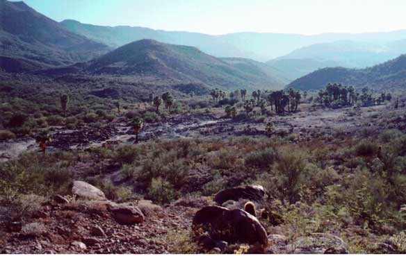
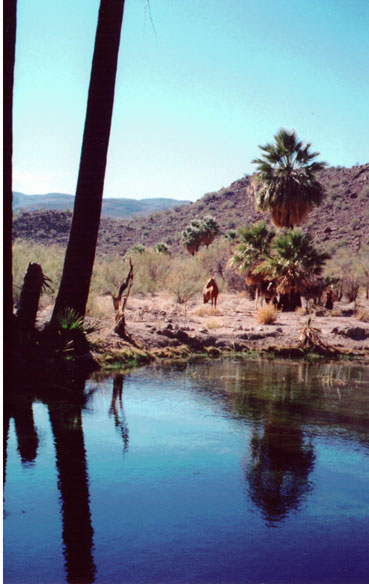
Regarding CARRIZO Canyon...
In my web site (VivaBaja.com), in the Contributed Photos section (bottom of home page) is a link to 'jide's' Sierra Juarez Canyon photos... His hike
into Carrizo photos begin on Page 4 (after the Tajo canyon pics)... Here's the link: http://www.vivabaja.com/jide/page4.html
And here is one of the photos at the Carrizo oasis...

|
|
|
Neal Johns
Super Nomad
Posts: 1687
Registered: 10-31-2002
Location: Lytle Creek, CA
Member Is Offline
Mood: In love!
|
|
The cold spring at Rancho Palomar must flow (no real pool) all year around as the large grove of palms must have there feet in water to survive.
The road south from Mile 34.2 is not on the Baja Almanac and starts at approximately 30 deg 50 min where the road on the Almanac for El Mano starts
west. To put it on the map, draw a line straight south from the above point to the location of Mile 38.8 (31 deg 45.6 min, 115 deg 33.5 min), then
draw a line mostly south - a little west - from there to join Canada la Parra a few tenths from where the road from the bottom of El Mano is shown
joining la Parra on the Almanac. From shortly before Mile 34.2, to Mile 41, you are on roads not shown on the Almanac. It's a shortcut!
No dotted line roads are used or significant.
Minor corrections will be made in a few minutes to the original.
Info not applicable to Agua Caliente route:
At Mile 38.8, if you bear left, down, off the few feet high "mesa", heading east toward Campo Victoria, in 0.85 miles there is a faint road right
going to the edge of the mountains just south of la Parra where the road continues south (there is a crossover road north to la Parra also) several
miles to Arroyo El Alamito (the bottom of El Alamito is not shown well on the Almanac), at 1.55 miles you cross sand wash Arroyo El Alamito which
frequently has tracks in it, at 2.44 miles you cross Arroyo de Enmedio. Campo la Victoria is at about Mile 5 or 6 and consists of concrete foundations
with Campo la Victoria scratched in them.
My motto:
Never let a Dragon pass by without pulling its tail!
|
|
|
David K
Honored Nomad
Posts: 65565
Registered: 8-30-2002
Location: San Diego County
Member Is Offline
Mood: Have Baja Fever
|
|
Neal, draw us a map (please)!
|
|
|
Neal Johns
Super Nomad
Posts: 1687
Registered: 10-31-2002
Location: Lytle Creek, CA
Member Is Offline
Mood: In love!
|
|
And take all the fun of getting lost out? Never!
Shane, don't forget to email me as requested above.
My motto:
Never let a Dragon pass by without pulling its tail!
|
|
|
Neal Johns
Super Nomad
Posts: 1687
Registered: 10-31-2002
Location: Lytle Creek, CA
Member Is Offline
Mood: In love!
|
|
OK, OK!
The miles noted on these maps are from Hwy. 2 and are different from the original directions. Ignore.
My motto:
Never let a Dragon pass by without pulling its tail!
|
|
|
Neal Johns
Super Nomad
Posts: 1687
Registered: 10-31-2002
Location: Lytle Creek, CA
Member Is Offline
Mood: In love!
|
|
Second map:
My motto:
Never let a Dragon pass by without pulling its tail!
|
|
|
Geothermal-Shane
Junior Nomad
Posts: 83
Registered: 5-14-2005
Member Is Offline
|
|
Thanks alot, Neal! I'll see what I'm getting myself into when I wander down there. This map of yours will be a crucial tool for maintaining sanity-
hopefully I can make it there in June, when temperatures can make sanity questionalble, especially in this kind of remote place.
Do you recall if there was a lot of deep sand the last two miles up the wash before Agua Caliente, or at any other part of the route?
(and how much of the route was negotiated with 4 wheel drive engaged?)
also...
Which route would you suggest I take to Agua Caliente coming from El Palomar?
Thanks alot!!!!!
|
|
|
Geothermal-Shane
Junior Nomad
Posts: 83
Registered: 5-14-2005
Member Is Offline
|
|
oh, thanks David K for the Carrizo photo and link!
|
|
|
Bruce R Leech
Elite Nomad
Posts: 6796
Registered: 9-20-2004
Location: Ensenada formerly Mulege
Member Is Offline
Mood: A lot cooler than Mulege
|
|
wow who says you cant get good info on this forum. nice job on the maps and directions David and Neal Johns and others
Bruce R Leech
Ensenada
 |
|
|
Neal Johns
Super Nomad
Posts: 1687
Registered: 10-31-2002
Location: Lytle Creek, CA
Member Is Offline
Mood: In love!
|
|
From Palomar:
Take the dotted line roads (very good roads in this case) to the solid road that goes to Mile 24.2 in log above which is 1.2 miles above CJ (Cajabuzo
Junction) , then follow log above.
Do not take the more logical looking road down right from near the lodge as it is very tediously bumpy.
I think the only place I used 4wd was the last half mile of rutted rocky road. However - the entire la Parra wash is soft sand. I was there in
moderate temperatures when the sand holds more moisture. In June, the moisture will be gone and so will the traction - makes an unbelieveable
difference. Try 20 pounds tire pressure.
You would be very foolish to go into this very isolated area with only one vehicle anytime, especially in June. There are no old, bold, desert rats
that tried to live without water.
Where is that email?aridneal atearthlink.net
My motto:
Never let a Dragon pass by without pulling its tail!
|
|
|
Neal Johns
Super Nomad
Posts: 1687
Registered: 10-31-2002
Location: Lytle Creek, CA
Member Is Offline
Mood: In love!
|
|
Desert Explorers (4WD section of the Barstow Mojave River Valley Museum) at Agua Caliente (31 deg, 40.32 min. - 115 deg. 38.66 min.)
http://desertexplorers.org
My motto:
Never let a Dragon pass by without pulling its tail!
|
|
|
Neal Johns
Super Nomad
Posts: 1687
Registered: 10-31-2002
Location: Lytle Creek, CA
Member Is Offline
Mood: In love!
|
|
I thought it was a pretty good joke posting all that stuff above just like I was a expert!
Here is the real sordid truth about the famous Aridologist Richard Neal Johns:
http://desertexplorers.org/tr-03NealsRescue/SizeCounts.htm
http://desertexplorers.org/tr-03NealsRescue/RescueMission.ht...
http://desertexplorers.org/tr-03NealsRescue/SearchRescueJohn...
http://desertexplorers.org/tr-03NealsRescue/TheTruth.htm
http://desertexplorers.org/tr-03NealsRescue/DearEditor.htm
My motto:
Never let a Dragon pass by without pulling its tail!
|
|
|
Geothermal-Shane
Junior Nomad
Posts: 83
Registered: 5-14-2005
Member Is Offline
|
|
email on its way...
I'll be accompanied by a big 2wd Dodge Ram for this trip, which is partly why I'm concerned about the need for 4X4. I don't know how this vehicle will
fair in such conditions...nor do I want to have to pull this big lug out of some treacherous sand. What are your thoughts on this factor?
If we make it in there to Agua Caliente it will between June 16 and 20. The plan seems to be as follows-
first go to Guadalupe Canyon, with an El Carrizo day trip
then Palomar Canyon,
then possibly Agua Caliente,
and then to Highway 5 via Cabajuzo Jct. which seems to be the preferred route as opposed to the one shown in the Baja Almanac. (????)
I estimate this should all take between 4 and 5 days. This may mean settling for warm water the last few days when the ice has all melted and gone
above 90 degrees. I plan on carrying 25 gallons of water and ten gallons of gas, along with two weeks worth of food. (and beer...ha ha) Two spare
tires this time. I've got a good water filter if necessary. If it comes down to tying bags around bushes, then mercy...
I don't expect to see many other travelers... although last year at the same time I saw five different carloads of Americans within two days. That was
on the graded dirt road from Highway 5 to Guadalupe Canyon, however. It seems that most of the locals don't drive cars, and can offer little help if
you get herranged.
"It's just you and the lord."
-Bobby Bradford, jazz music teacher
|
|
|
| Pages:
1
2
3 |


