| Pages:
1
2
3
4 |
Sharksbaja
Elite Nomad

Posts: 5814
Registered: 9-7-2004
Location: Newport, Mulege B.C.S.
Member Is Offline
|
|
well then.....
| Quote: | Originally posted by The squarecircle
As Gov. Arnold would say >> "LETS DO IT" >> sq. |
OK! Methinks October would be best. Time to plan and research and the weather perfect.
|
|
|
honda tom
Nomad
Posts: 493
Registered: 8-28-2003
Location: middle calif
Member Is Offline
|
|
About half way between los corrales and the "head west point " (la trinidad) there is a 60 foot deep canyon that goes out to the ocean. We went inland
somewhat and dropped into the canyon, headed back toward the ocean, then "cow tracked" up a 2 foot wide single track. At the time that was the only
way across this deep ravine. Idont think anyone is going through in a 4 wheeled vehicle. Some friends did this on quads, and at the ravine they had
to walk the quads up.... 3 guys 1 quad.. then repeat. If i was going to check this place out in vehicles i would come in from the north. santa marta
is really a cool place surrounded by giant mountains, but the road to trinadad from there hits some really slow going rocky sections. Bring lots of
gas and prepare to be ALONE.
|
|
|
Sharksbaja
Elite Nomad
Posts: 5814
Registered: 9-7-2004
Location: Newport, Mulege B.C.S.
Member Is Offline
|
|
Honda, TW, Square C.......
It looks from space that there is not a passable route near the coast. Here I have drawn over what appears to be tracke or dirt roads. Some are very
vague and may not be a route at all. Cant get good res so I need better sat maps. Does any of this look familiar?
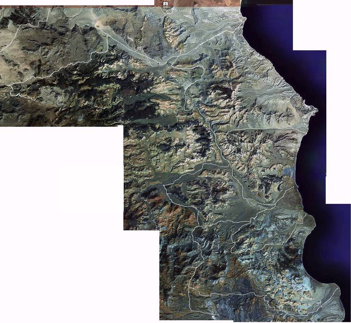
here is a road north of S. Rosalia that has potential:
http://maps.google.com/maps?ll=27.523499,-112.627029&spn...
|
|
|
TMW
Select Nomad
Posts: 10659
Registered: 9-1-2003
Location: Bakersfield, CA
Member Is Offline
|
|
In comparing the satellite photo to the Baja Almanac, the top right point looks like El Barril and the bottom right point looks like Punta San Carlos.
Los Carrales would be the next point above San Carlos.
[Edited on 5-24-2005 by TW]
|
|
|
honda tom
Nomad
Posts: 493
Registered: 8-28-2003
Location: middle calif
Member Is Offline
|
|
use the almanac to get to los corrales.... then you'll follow tracks along the beach sometimes heading inland a few hundred yards. the gorge will
probably be your dead end.
|
|
|
Barry A.
Select Nomad
Posts: 10007
Registered: 11-30-2003
Location: Redding, Northern CA
Member Is Offline
Mood: optimistic
|
|
sharks----
Wow, good work with the SAT photos-----opens up all kinds of possible roads to explore, or confirm that they are there, or not, not only for the
coast, but inland also.
Good stuff!!!!!
Thanks, Barry
|
|
|
Sharksbaja
Elite Nomad
Posts: 5814
Registered: 9-7-2004
Location: Newport, Mulege B.C.S.
Member Is Offline
|
|
water source?
Does someone know if there is a water source en route to Los Corrales via El Barril?
|
|
|
Barry A.
Select Nomad
Posts: 10007
Registered: 11-30-2003
Location: Redding, Northern CA
Member Is Offline
Mood: optimistic
|
|
Sharks----
We had all our own water with us in 2000, but I would assume that there is water available at the active Rancho San Miguel----assuming that it is
still active. We saw no natural flowing water in April of that year, that I can recall.
|
|
|
cpg
Nomad
Posts: 262
Registered: 4-10-2006
Location: Livermore, Ca.
Member Is Offline
|
|
The road is washed out in a few places but there are work arounds. Very long drive in a 4x4 and the deep sand washes suck gas. Here is a pick of as
far as I made it. I drove for about 4 hours south of el barril.
|
|
|
cpg
Nomad
Posts: 262
Registered: 4-10-2006
Location: Livermore, Ca.
Member Is Offline
|
|
heres the pick n 28 09.721 w 112 55.613
|
|
|
Barry A.
Select Nomad
Posts: 10007
Registered: 11-30-2003
Location: Redding, Northern CA
Member Is Offline
Mood: optimistic
|
|
cpg------
----did you get south of Rancho San Miguel????? and is your pic of the end of the line??
|
|
|
cpg
Nomad
Posts: 262
Registered: 4-10-2006
Location: Livermore, Ca.
Member Is Offline
|
|
Hi Barry
It was not the end of the line. The gps cord's above is where we turned around. We had to re route because of wash outs and used a lot of gas in the
deep sand (4 low).
I was way of the baja almanac and the lb map trach for los coralles. From the gps seemed like I was over half way there. Some of the road was great
some places no road and some very rough and steep. Very wide range of terrain. The baja almanac makes it seem to be a flat road most of the way. The
pat we took was not flat. I will try to post the route at some point. This pic is near where we turned around. About a mile after a very steep
climb.
|
|
|
cpg
Nomad
Posts: 262
Registered: 4-10-2006
Location: Livermore, Ca.
Member Is Offline
|
|
another
|
|
|
cpg
Nomad
Posts: 262
Registered: 4-10-2006
Location: Livermore, Ca.
Member Is Offline
|
|
the last 2 about half way in
|
|
|
KurtG
Super Nomad
Posts: 1201
Registered: 1-27-2004
Location: California Central Coast
Member Is Offline
Mood: Press On Regardless!!
|
|
| Quote: | Originally posted by honda tom
I rode from san fran through los corrales, south on the beach to trinadad.... then inland to santa marta and down to hwy 1. friends of mine refer to
it as the Malcolm Smith trail. I dont know who showed Malcolm... but thats what i call it. The beach south of los corrales is beautiful, it is the
most "alone" i have ever felt in baja. 4 of us did it on bikes with oversized tanks and about 1/2 a gallon of gas in plastic jugs. I think the total
mileage to san ignacio was about 150. |
Kacey Smith's Baja GPS Guide gives that entire route, I have heard lately that the trail is in very bad shape and may not be doable but have no first
hand info.
|
|
|
Barry A.
Select Nomad
Posts: 10007
Registered: 11-30-2003
Location: Redding, Northern CA
Member Is Offline
Mood: optimistic
|
|
cpg----
----Great pictures, and thanks for your response.
In 2000, we got about a mile (maybe 2?) SE of Rancho San Miguel in a F-250 4x4 ext. cab, long bed, w/1000 lb. Callen camper, and 285x16 tires, but the
wash sand was so soft, and we were so far from help, that we chickened out. Vague tracks did head on from where we turned around, tho, on towards Los
Corrales and La Calera. You obviously went much farther SE than we did. I can certainly vouch that there is VERY soft wash sand----the worse
(softest) I have ever encountered in Baja-----(after a good rain I think it would be fine, tho.)
In the Almanac, there is a dotted line from Rancho San Miguel NE out to the coast. In fact, that is a good road, easily driven by our vehicle, and we
camped right on the coast, behind a cobble coastal berm, at an old abandoned Fish Camp----location being right about where the Almanac shows the end
of the dotted line at Estero la Palmita. Long and nice beaches north of our campsite along the face of a "barrier island" (sand spit?). There were
extensive coastal marshes and tidal flats just north of our camp, as is indicated in the Atlas. We did not venture out on that mud flat because of our
horrible "stuck" experience at Boca Grande above San Rafael, (N. of San Francisquito) a few days before. Of interest, there is a very sophisticated
but abandoned Ejido with many structures, dams, cement irrigation canals, etc. half way between Rancho San Miguel and the coast, along this road to
Estero San Palmita. They had been relying on the waters from Canon San Miguel, but apparently the weather let them down and there was not enough
water. (Typical Baja story) At the ejido site is a really beautiful masonary bldg. in excellent condition, and then a lot of foundations and small
rock shelters scattered all over the place. Somebody (Mex. govt?) spent a lot of dinero at this place, once upon a time.
From the time we left El Barril heading south (total 3 days) we saw only the folks living at Rancho San Miguel (very nice folks)-----nobody else, and
no vehicles. This is magnificent country--some of the best I have ever seen in Baja-----and the Palo Blanco trees along La Fortuna wash (San Miguel
wash?) are spectacular. This IS old-time Baja, for sure. We did not try any coastal fishing----just not time.
When I buy a new Toyota FJ Cruiser , I will return to see more of this country,
for sure. , I will return to see more of this country,
for sure.
Thanks for your reports, and I hope you are able to return someday and continue the "push south".
|
|
|
ArvadaGeorge
Nomad
Posts: 358
Registered: 9-2-2003
Member Is Offline
|
|
This story is that route
in 1985 w/photos
http://forums.bajanomad.com/viewthread.php?tid=16345&pag...
|
|
|
cpg
Nomad
Posts: 262
Registered: 4-10-2006
Location: Livermore, Ca.
Member Is Offline
|
|
Barry
Did you drive up a very steep 4 lo hill? About 2,000 yards with 3 switch backs. Up to the top than down into a large wash. There was a shelter and a
lot of barbed wire laying about near the bottom looks like it was there for years.
The changes in terrain are very spectacular. We saw lush sand washes, Flat desert, Caves, Mountains, Rock gardens, many different plants. My wife and
I alone in our trusty 96 cruiser with 169,900 miles felt very remote. Made trips to Death Valley like going to the corner market.
George your story is one hell of a adventure. I hope to take my XR 600 next time to scout. Thanks for posting that story. Cant wait to get back there
again.
|
|
|
Barry A.
Select Nomad
Posts: 10007
Registered: 11-30-2003
Location: Redding, Northern CA
Member Is Offline
Mood: optimistic
|
|
cpg----
------no very steep hill-----we apparently did not get as far south as you, or were on a different track out of Rancho San Miguel (of which there were
several). We essentially were driving down a very sandy wash to the SE of the Rancho and the traction was getting more and more squirrly-----since we
were driving down the wash, this made me very apprehensive knowing that we probably had to drive back up the wash to get out of there. Like I said,
we just chickened out.
|
|
|
cpg
Nomad
Posts: 262
Registered: 4-10-2006
Location: Livermore, Ca.
Member Is Offline
|
|
barry,
Yes we drove for a long time in a wash like tha for a long time I went down to 12 psi and locked the rear diff. It was taking lots of fuel to make it
down. When I started to think about getting stuck it was a little spooky. How much gas do you carry?
|
|
|
| Pages:
1
2
3
4 |


