John M
Super Nomad

Posts: 1906
Registered: 9-3-2003
Location: California High Desert
Member Is Offline
|
|
2nd Route El Marmol to the Gulf
Desert Magazine, January 1959, page 10 also shows a route from El Marmol to the gulf. This is not the same route as the earlier post. This route
appears to reach the gulf 8 to 10 miles north of Puertecitos. The article which the map is a part of is titled "Trail to a Baja Salt Spring," by
Louise Werner.
The trail I wrote of is not discussed in the narrative of the article and is only a dotted line on the map.
The "salt spring" in the title appears to be near the white hillside you can see clearly from the gulf just a couple of miles into the hills west of
Rancho Grande, at Gonzaga Bay. There are no clear directions as to the hike Louise took but the description seems to fit.
John M
|
|
|
Barry A.
Select Nomad
Posts: 10007
Registered: 11-30-2003
Location: Redding, Northern CA
Member Is Offline
Mood: optimistic
|
|
John-----
I am a little confused------you say that Louise Werner's route from El Marmol comes out about 8 to10 miles north of Puertecitos, and then further down
you mention that the L. Werner article is about a trail to a "salt spring" which you think if west of Rancho Grande????? Rancho Grande is some 50
miles south of Puertecitos-----how can these two places be connected??
I believe that I have that copy of that Desert Mag., but I will have to check tomorrow.
|
|
|
John M
Super Nomad
Posts: 1906
Registered: 9-3-2003
Location: California High Desert
Member Is Offline
|
|
Confusing writing
Barry - Louise Warner's article is about a hike she and her husband took a spring located near Gonzaga Bay. It looks to me like the hike area is being
shown at the very bottom of the map.
The route to El Marmol shown on the accompanying map has no connection to the story she tells; it's just drawn in. I brought it to the forum here
because from time to time there has been talk of finding a way to get to the gulf from El Marmol.
John M.
[Edited on 10-15-2005 by John M]
|
|
|
TMW
Select Nomad
Posts: 10659
Registered: 9-1-2003
Location: Bakersfield, CA
Member Is Offline
|
|
If your hiking from El Marmol to the gulf just follow the El Volcan wash. From a hiking standpoint the only known obsticle is the water fall section
Corky found on the eastern end. But I'm sure that can be bypassed or gone down maybe. The route most of us have been looking for is to ride a
motorcycle thru and that won't be done in the El Volcan unless maybe your a trials rider and a good one.
|
|
|
John M
Super Nomad
Posts: 1906
Registered: 9-3-2003
Location: California High Desert
Member Is Offline
|
|
TW - M/C route
TW, the first posting I made last night - from the 1927 map - looks to be much more of a direct route to the gulf. Not as straight line as following
El Volcan wash, but not that great a detour to the north.
Comparing the 1927 map in my other post to possible routes using the Baja Topographical Atlas, it does appear to follow a series of other washes all
the way to the gulf. More research is needed and I may try to overlay the 1927 route onto the Topo Atlas later today and see what it looks like.
John M
|
|
|
David K
Honored Nomad
Posts: 64476
Registered: 8-30-2002
Location: San Diego County
Member Is Offline
Mood: Have Baja Fever
|
|
Gee, you guys are starting to see the things I get excited over!
Desert Magazine published and edited by Choral Pepper and others was the 'Baja Nomad' of its time...
John, you found the article about the onyx springs (soda springs)... Norm Christie (of Punta Final, and 'Rockman' here on Nomad) teased me a few years
ago... So, I went searching for them...
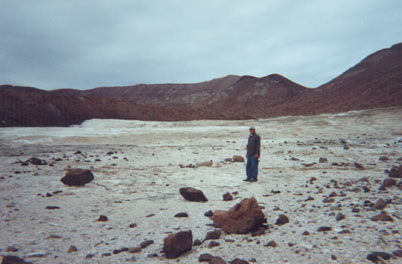
Looking west, they cover a huge area around where I am shown standing (can be seen on satellite images, and from the beach near the palapas of Rancho
Grande)
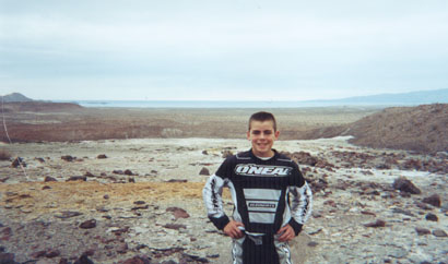
Here's my son (Nov. '02) at the springs with Gonzaga Bay in the background.
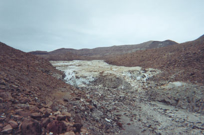
When you hike to them, you come to what looks like a glacier, and climb up it (that's not ice, however!)
These photos and more Gonzaga Bay side trips begin at http://vivabaja.com/1102/page2.html
The map showing the trail going north of Puertecitos is fiction or a mistake, I believe.
Viva Baja Exploring!!!
|
|
|
David K
Honored Nomad
Posts: 64476
Registered: 8-30-2002
Location: San Diego County
Member Is Offline
Mood: Have Baja Fever
|
|
Oh, Tim Walker ( http://TimsBaja.com ) went to them after I first published these photos and he has some nice pictures in his web site of them, as well... He has a
better camera then I had in 2002!
Norm requested that I not give the GPS for them, since he told me about them before I found them and Tim also honored that request on his web page for
the Onyx Springs.
The concern Norm had was people walking on the thin crystal sheets, which can be avoided... So please walk only on the 'uglier' mineralized ground,
when you go there!
To read what Tim had to say and see his photos:
http://www.timsbaja.com/jan03trip/jan03trip3.html
[Edited on 10-15-2005 by David K]
|
|
|
John M
Super Nomad
Posts: 1906
Registered: 9-3-2003
Location: California High Desert
Member Is Offline
|
|
Werner photo
Later I'll post the Louise Werner photo from the article. She included GPS points in her 1959 story I think.
John M.
|
|
|
bajalou
Ultra Nomad
Posts: 4459
Registered: 3-11-2004
Location: South of the broder
Member Is Offline
|
|
Nelson's 1905/6 map shows a road (trail) from Onyx south to Mission Santa Maria and on to Gonzaga Bay. Just south of Onyz it shows a road (trail)
heading almost directly east to Miramar and thense to Miramar Landing. Nothing from the Puertocitos area (which doesn't show either)
It also shows a trail from Matomi southeast to Miramar and from Matomi west to Suerte and eventually Rosario. (added with the edit)

[Edited on 10-15-2005 by bajalou]
No Bad Days
\"Never argue with an idiot. People watching may not be able to tell the difference\"
\"The trouble with doing nothing is - how do I know when I\'m done?\"
Nomad Baja Interactive map
And in the San Felipe area - check out Valle Chico area |
|
|
John M
Super Nomad
Posts: 1906
Registered: 9-3-2003
Location: California High Desert
Member Is Offline
|
|
Map in Nelson
Bajalou, you're right, the route on the Nelson map is looking nearly the same as the 1927 map of Meigs, that I posted. The copy of Nelson's map I have
is from the reprint edition by Mannesier and might be a little different than an original.
|
|
|
Corky1
Nomad
Posts: 416
Registered: 11-22-2003
Member Is Offline
|
|
John,
This is the location of the rock wall.
Wall location 30 degree-05.2' --114 degree-41.59'
We walked further up the wash to this location.
30 degrees-0.495'--114degree-43.43'
If you are hiking, no problem going up or down the wall.
We started at Nachos well and went East.
We took the left fork going E/B to get to this location.(the wall)
Hope this helps you locate things on the map you are using.
Corky
PS did I answer your PM about Cannady??
 
\"Keep The Rubberside Down\" |
|
|
David K
Honored Nomad
Posts: 64476
Registered: 8-30-2002
Location: San Diego County
Member Is Offline
Mood: Have Baja Fever
|
|
Nelson's 1905 Map, published in 1919...
Here is the close up of the same area discussed...
Again you can see San Agustin, "Onyx" (El Marmol), Miramar, Miramar Landing, Mesquite (Agua del Mezquitito) shown on the other 1905 map... plus 'Los
Vazcos'?
[Edited on 10-15-2005 by David K]
|
|
|
David K
Honored Nomad
Posts: 64476
Registered: 8-30-2002
Location: San Diego County
Member Is Offline
Mood: Have Baja Fever
|
|
1905 Mines and Roads Map
This map is titled: Mapa de las Minas Y Caminos de la Baja California de Exploracions y surveys por Richard Stephens C.E. 1905.
I scanned the area of interest... the trail from El Marmol to the gulf...
From the left, listed is San Agustin, Onyx Quarries (El Marmol), Miramar Placers, Landing (Okie's Landing of 50 years later, perhaps?)...
[Edited on 10-16-2005 by David K]
|
|
|
Barry A.
Select Nomad
Posts: 10007
Registered: 11-30-2003
Location: Redding, Northern CA
Member Is Offline
Mood: optimistic
|
|
Good stuff, David-----
I have made copies of all these maps, and they came out pretty good. Can't wait to go down this winter and check them out.
Thanks again. Barry
|
|
|
bajalou
Ultra Nomad
Posts: 4459
Registered: 3-11-2004
Location: South of the broder
Member Is Offline
|
|
Barry - if you come thru San Felipe, stop by - we can swap lies about Baba.

No Bad Days
\"Never argue with an idiot. People watching may not be able to tell the difference\"
\"The trouble with doing nothing is - how do I know when I\'m done?\"
Nomad Baja Interactive map
And in the San Felipe area - check out Valle Chico area |
|
|
bufeo
Senior Nomad
Posts: 793
Registered: 11-16-2003
Location: Santa Fe New Mexico
Member Is Offline
|
|
I'm finding this an interesting thread since we frequent the area and we've driven/hiked up all three of those arroyos west of 'Miramar'.
PS (on edit) Cork, you can make the degree symbol by holding down the ALT key and keying 0-1-8-6 on the number pad, as in N30? 05'. Less key
strokes.
|
|
|
John M
Super Nomad
Posts: 1906
Registered: 9-3-2003
Location: California High Desert
Member Is Offline
|
|
For Corky
Thanks for the GPS readings.
I don't think I got your answer on Cannady though. Is he in Baja often?
I brought the Meigs map from the other thread here -
John M
[Edited on 10-16-2005 by John M]
|
|
|