| Pages:
1
2 |
David K
Honored Nomad

Posts: 65568
Registered: 8-30-2002
Location: San Diego County
Member Is Offline
Mood: Have Baja Fever
|
|
El Rosario to Punta Baja and south along the coast! (Part 1 and Part 2)
Last Weekend (Dec. 10, 2005) Baja Angel and I celebrated one year since we met and began dating... No better place to celebrate than in beautiful Baja
California, right?
The Baja Cactus Motel makes a great base camp from which to explore the many sites around El Rosario. Over the past year we have driven out in all
directions taking each road with anticipation of fun and adventure!
Close to El Rosario we have seen missions, a museum, a petrified forest, a beautiful sand beach, a stunning shoreline, a fascinating sea lion cave
with a 'sky light', cactus forests, old mines, petroglyphs, fossils, springs, and more!
One remaining dirt road from El Rosario waiting for us was the one along the coast from Punta Baja down to almost Punta San Carlos... That was what we
drove last Saturday.
The first thing is to top off the gas at Baja Cactus Pemex then go the few hundred feet south to where the highway makes the sharp left 90? turn...
except you go RIGHT, and set your trip odometer to 0.0 miles.
In less than a tenth of a mile (or <528 feet) the wide dirt road forks, go LEFT (a torta and hamburger stand is at the split) and drop into the El
Rosario River basin... in the middle at Mi. 0.3 turn right, down river on the main traveled road.
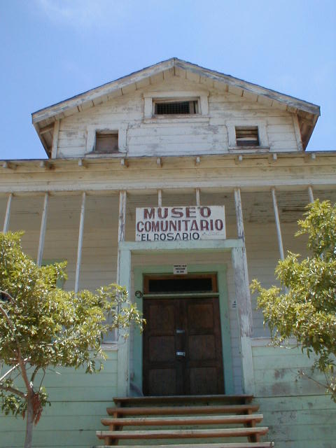
At mile 1.0 you will climb out of the river basin onto the south bank and continue westward entering the town of El Rosario de Abajo. Mile 1.4+ is the
El Rosario Museum, on the left...
Photo of museum taken last May:
Mile 1.6 are the ruins of the second site of the Rosario mission, on the right.
Photo of mission taken last May:

Mile 2.5 is a major fork: To head south on the coast road, turn left. To head first to Punta Baja, go right... We went to Punta Baja first...
Mile 2.9 is the next major fork... The main road turns left for Punta Baja. Ahead and then right into the river basin goes to La Bocana beach (4WD
best on this road). Going right, back at the hamburger stand just off the pavement is a 2WD route to La Bocana.
There are many yuccas in this area and several had there blossem tips cut off! Perhaps for some marketable product?
Mile 8.7 is a major fork, left is the route that follows the coast, joining the road that forked at Mi. 2.5 after 5.6 miles.
Mile 9.9 the road descends into the village of Punta Baja and at Mile 10.5 is the end of the road at the Punta Baja lighthouse.
Photo of de-blossemed yuccas...
[Edited on 12-24-2006 by David K]
|
|
|
David K
Honored Nomad
Posts: 65568
Registered: 8-30-2002
Location: San Diego County
Member Is Offline
Mood: Have Baja Fever
|
|
If the blossems were too high, the stock was first cut, then the flower tip removed...
[Edited on 12-14-2005 by David K]
[Edited on 4-25-2007 by David K]

|
|
|
David K
Honored Nomad
Posts: 65568
Registered: 8-30-2002
Location: San Diego County
Member Is Offline
Mood: Have Baja Fever
|
|
Punta Baja is a finger of land pointing to the South Pacific!
[Edited on 4-25-2007 by David K]

|
|
|
David K
Honored Nomad
Posts: 65568
Registered: 8-30-2002
Location: San Diego County
Member Is Offline
Mood: Have Baja Fever
|
|
This puppy came over when we parked by the lighthouse... The coast heading south is seen...
[Edited on 4-25-2007 by David K]

|
|
|
David K
Honored Nomad
Posts: 65568
Registered: 8-30-2002
Location: San Diego County
Member Is Offline
Mood: Have Baja Fever
|
|
Baja Angel enjoys the crisp sea air!
[Edited on 4-25-2007 by David K]

|
|
|
David K
Honored Nomad
Posts: 65568
Registered: 8-30-2002
Location: San Diego County
Member Is Offline
Mood: Have Baja Fever
|
|
The lighthouse...
[Edited on 4-25-2007 by David K]

|
|
|
David K
Honored Nomad
Posts: 65568
Registered: 8-30-2002
Location: San Diego County
Member Is Offline
Mood: Have Baja Fever
|
|
Just south of Punta Baja, the yucca is king!
Distant Isla San Geronimo is seen on many occaisions today.
Stay tuned for Part 2 of our trip along this quiet coastline...
[Edited on 4-25-2007 by David K]

|
|
|
PabloS
Nomad
Posts: 187
Registered: 4-8-2003
Location: North central AZ
Member Is Offline
|
|
David, What was the Museo buildings first use and when? I always figured the Agave tip and stalks were cut for animal(pig/cattle feed) but don't
really know. 
|
|
|
David K
Honored Nomad
Posts: 65568
Registered: 8-30-2002
Location: San Diego County
Member Is Offline
Mood: Have Baja Fever
|
|
It was the old school house...
The larger tree-yuccas are being havested for some kind of cosmetic product, but the flower bud on these smaller yuccas or agaves have some use I am
unaware of...
|
|
|
PabloS
Nomad
Posts: 187
Registered: 4-8-2003
Location: North central AZ
Member Is Offline
|
|
Any idea on the age of the schoolhouse? We have seen the tips and stalks cut for at least the last 20 years.
BTW, great photos!
|
|
|
David K
Honored Nomad
Posts: 65568
Registered: 8-30-2002
Location: San Diego County
Member Is Offline
Mood: Have Baja Fever
|
|
The inside of the museum photos are at http://vivabaja.com/505
I think in one of the El Rosario flyers I saw during the festival last July had the school dates... ??
|
|
|
David K
Honored Nomad
Posts: 65568
Registered: 8-30-2002
Location: San Diego County
Member Is Offline
Mood: Have Baja Fever
|
|
Part 2
The next few miles we tried various routes from Punta Baja south on the coast, but the last big rains washed out the one closest to the coast... As my
milage bumped around a bit, I will give some GPS waypoints, as well.
0.0 Leave Punta Baja road, head south: 29-58.39', 115-47.17' (A)
0.6 Take left fork.
0.9 Reach original coast road, turn left: 29-57.69', 115-46.79' (B)
We follow along and poke around looking to stay close to the coast and come across Gloria, a German lady with her dogs. She kindly came out of her
little cabin to point out an unseen road that drops straight off the cliff to continue on. Gloria tells us she is seeking God... or perhaps to better
understand Him?
Mile 5.6: after heading inland and passing the striped mountain, we reach the main coastal road that forked from the Punta Baja road back at Mile 2.5:
29-57.88', 115-43.77' (C)
Reset odometer to 0.0! The AAA map says it is 5.6 miles back to the mile 2.5 junction.
Here is the striped mountain...
[Edited on 4-26-2007 by David K]

|
|
|
David K
Honored Nomad
Posts: 65568
Registered: 8-30-2002
Location: San Diego County
Member Is Offline
Mood: Have Baja Fever
|
|
Mile 1.6 (29-56.58', 115-43.32') a road heads westward to the coast... this could be Agua Blanca on the map... we continue south... (D)
Mile 2.7 Road west... we continue south...
Mile 5.3 Road west... we continue south...
Mile 13.3 Road winds down into a mud canyon (Arroyo San Vicente)... see photo...
[Edited on 4-26-2007 by David K]

|
|
|
David K
Honored Nomad
Posts: 65568
Registered: 8-30-2002
Location: San Diego County
Member Is Offline
Mood: Have Baja Fever
|
|
Mile 15.2 Fork, we turn right...
Mile 19.6 Coast and a 'bird rock' just offshore...
This burro was minding his own business...
[Edited on 4-25-2007 by David K]

|
|
|
David K
Honored Nomad
Posts: 65568
Registered: 8-30-2002
Location: San Diego County
Member Is Offline
Mood: Have Baja Fever
|
|
Mile 20.5 Fish camp with a concrete boat launch ramp... 29-44.65', 115-40.64' (E)
This is just south of Punta San Antonio, up until which the San Geronimo island was constantly in our view any place we could see the ocean.
[Edited on 4-26-2007 by David K]

|
|
|
David K
Honored Nomad
Posts: 65568
Registered: 8-30-2002
Location: San Diego County
Member Is Offline
Mood: Have Baja Fever
|
|
Mile 23.4 Arroyo San Fernando
Mile 25.2 Road come in from northwest (back, left)
We come to a cliff just as the sun is ready to set and lights up the land, as it is below the cloud cover we had all day...
In the distance is the San Carlos mesa.
[Edited on 12-14-2005 by David K]
[Edited on 4-25-2007 by David K]

|
|
|
David K
Honored Nomad
Posts: 65568
Registered: 8-30-2002
Location: San Diego County
Member Is Offline
Mood: Have Baja Fever
|
|
Sundown, December 10, 2005
[Edited on 4-25-2007 by David K]

|
|
|
David K
Honored Nomad
Posts: 65568
Registered: 8-30-2002
Location: San Diego County
Member Is Offline
Mood: Have Baja Fever
|
|
Baja Angel (Elizabeth)
[Edited on 4-25-2007 by David K]

|
|
|
David K
Honored Nomad
Posts: 65568
Registered: 8-30-2002
Location: San Diego County
Member Is Offline
Mood: Have Baja Fever
|
|
Mile 27.3 Big fish camp... Campo Nuevo on the map 29-41.90', 115-36.05' (F)
Mile 31.4 Leave coast and head east
Mile 33.7 Reach the Punta San Carlos road 29-40.78', 115-32.09' (G)
Punta San Carlos is about 6 1/2 miles to the right (south).
Hwy. 1 is 31 miles to the left, north (jcn. at Km. 80)
Back at Baja Cactus Motel, I took a photo of the bookcase that will hold the future Baja book library collection.
[Edited on 4-26-2007 by David K]

|
|
|
Diver
Ultra Nomad
Posts: 4729
Registered: 11-15-2004
Member Is Offline
|
|
Wow, it's been a year already ? Seems like just yesterday !
Congrats on your first year of many in harmony.
I must assume there is harmony as every photo you have posted of Angel shows her big smile ! Keep up the good .... work? (nah)
BTW, I would love two more large stickers for our new rigs before our trip south in early January.
|
|
|
| Pages:
1
2 |


