David K
Honored Nomad

Posts: 64558
Registered: 8-30-2002
Location: San Diego County
Member Is Offline
Mood: Have Baja Fever
|
|
TINAJA DE YUBAY (trail details and photos)
One of the most important water holes along the El Camino Real was Yubay... Not a natural spring, but a tinaja or natural water reservoir in the shade
of large rocks where infrequent rains would fill the basin, and water remained to serve the natives, padres, Spanish soldiers, and prospectors of
Baja's past.
Yubay is reached by driving the L.A. Bay highway about 7 miles east of Hwy. 1, then north on the signed Rancho San Luis dirt road.
In less than three miles you join with the old L.A. Bay road (pre 1974) and will be heading west. A half mile later is a fork, left for Desenga?o (in
1/4 mile) and Hwy. 1 (9 miles), or right for Yubay.
In 2.8 miles, take the (only) road going right/east. Ahead/north goes over 4 miles to an area I call 'Rock Palm Hill' with many blue palms growing out
of granite cliffs.
East of you is this cone shaped hill (Cerro la Palmita) you drive towards, then the road will then turn north and continiue to Yubay with this hill a
good landmark to the south...

The road ends in a wide sand wash where you can park and begin the 3/4 mile hike (2WD should park on the hill before the drop into the wash). The
trail (El Camino Real era) continues over a low hill to Arroyo de Yubay, which joins the sand wash to the east of this trail head. Here is the view
looking towards Yubay (in a small canyon ahead) from the trail head...

Here are some GPS waypoints (at the factory map datum setting of WGS84):
GPS DIRECTIONS TO YUBAY (WGS 84)
JCN. hwy.1 & L.A. Bay hwy. N29?02.76' W114?09.17' 0.0 mi.
TURN NORTH onto dirt road N29?04.31' W114?02.41' 7.0 mi.
FORK right (left is Desengano, 0.3 mi.) N29?06.84' W114?01.65' 10.0 mi.
JCN. go right (ahead to rock palm hill, 4.2 mi.) N29?09.17' W114?01.40' 12.8 mi.
RIDGE TOP, 4WD only beyond N29?10.19' W113?59.77' 14.8 mi.
END OF ROAD in arroyo/TRAIL is straight across N29?10.29' W113?59.65' 14.9 mi.
TINAJA DE YUBAY N29?10.69' W113?59.26' 15.5 mi.
note: milages are direct, not road miles.
The trail drops into the arroyo which you follow into a small canyon... After rains there are many pools along here as Neal Johns discovered in 2002
(see http://vivabaja.com/neal2 ). When our group hiked up, it was a very hot July afternoon...
Here is the tinaja looking down from the rocks just above...

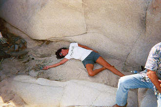
El Camote video's us resting in the shade... that's Mike Humfreville in the foreground!

Hiking back out, we find one who didn't make it... that's Debra ('travelpearl') with her cell phone unable to reach help from the central Baja
desert....
We reach our vehicle, and I find the nearest boojum tree to kiss in thanks to have gotten out alive!

From Neal Johns' photos, here's the view south from above Yubay, out the canyon and the cone shaped Cerro La Palmita in the distance...

|
|
|
PabloS
Nomad
Posts: 187
Registered: 4-8-2003
Location: North central AZ
Member Is Offline
|
|
Thanks DK, when I tried to find it a couple of years ago we got lost and gave up. Now I have saved and will print a copy before our next expedition

|
|
|
David K
Honored Nomad
Posts: 64558
Registered: 8-30-2002
Location: San Diego County
Member Is Offline
Mood: Have Baja Fever
|
|
Good morning Pablo,
I just sketched a map to help visualize the way into Yubay...
At the end of the road (in the sandy arroyo)... I show a dashed line continuing towards Yubay. This is a short cut trail that saves going down to
where the Yubay arroyo and the sandy arroyo join and making a longer hike up to the tinaja... many start their hike down there.
The great aridologist Neal Johns showed this trail to me a few years ago when I took the Viva Baja gang up there. This was the El Camino Real going
on north from Yubay, where probably all who walked or rode the mission trail took the side trail to get water, up in that little canyon.
A fig tree grows on the cliff next to the true Yubay, as there is often water in a couple places downstream from the real Yubay. Do see Neal's photos
from Feb. 2003, and more GPS data at http://vivabaja.com/neal2 Don Jorge has photos of Yubay also in one of his web pages at southcoastfarms.com.
Enjoy exploring the area! The small caves have Indian paintings and there is an ore grinding arrastra in one... above the canyon floor... I have
heard...
|
|
|
Ken Cooke
Elite Nomad
Posts: 8923
Registered: 2-9-2004
Location: Riverside, CA
Member Is Offline
Mood: Its Pole Line Road time
|
|
| Quote: | Originally posted by PabloS
Thanks DK, I have saved and will print a copy before our next expedition
|
X2. Neal said this is a great trip that is plenty of fun for the 4WDs...
|
|
|
Jack Swords
Super Nomad
Posts: 1094
Registered: 8-30-2002
Location: Nipomo, CA/La Paz, BCS
Member Is Offline
|
|
Exploring Tinaja de Yubay
Having spent many trips in this wonderful spot, we discover more on each visit. Mountain lion tracks are all over and very old rock walls are
scattered around. The arrastra is found within a cave as is the attached painting. Takes some hiking and rock climbing to truly appreciate the area.
|
|
|
David K
Honored Nomad
Posts: 64558
Registered: 8-30-2002
Location: San Diego County
Member Is Offline
Mood: Have Baja Fever
|
|
Thanks Jack for reminding me that you have some great Yubay photos too! Like the pintura one you posted...
I host them at http://vivabaja.com/swords
Jack has so many great photos of old ruins in that site above and the missions too (they are at http://vivabaja.com/bajamissions )
Just SO MUCH BAJA!!!!
|
|
|
Neal Johns
Super Nomad
Posts: 1687
Registered: 10-31-2002
Location: Lytle Creek, CA
Member Is Offline
Mood: In love!
|
|
Ken,
Take the road past the Yubay turnoff and continue north past Rock Palm Hill (turn left in the sandwash you hit). The Yubay turnoff road is no problem.
My motto:
Never let a Dragon pass by without pulling its tail!
|
|
|
David K
Honored Nomad
Posts: 64558
Registered: 8-30-2002
Location: San Diego County
Member Is Offline
Mood: Have Baja Fever
|
|
In the area near where the road turns right for Yubay or straight for Rock Palm Hill...

Rock Palm Hill...

also...

|
|
|
thebajarunner
Ultra Nomad
Posts: 3688
Registered: 9-8-2003
Location: Arizona....."Free at last from crumbling Cali
Member Is Offline
Mood: muy amable
|
|
And don't try the Easterly branch that comes out in the "big dip" on David's map unless you are seriously into running in deep soft sand.
Pretty embarrassing for an old Baja racer to get buried as badly as I did last year.
Also, some references would have you believe that the water hole is sort of pristine, and a likely swimming spot....
NOT!!! unless you are into swimming in serious algae and tadpoles.
But it is a lovely place, nonetheless.
We used David's GPS coordinates, and it was funny, standing in the middle of the road at a "Y" and seeing the exact numbers come up.
|
|
|
David K
Honored Nomad
Posts: 64558
Registered: 8-30-2002
Location: San Diego County
Member Is Offline
Mood: Have Baja Fever
|
|
That's the idea!
Mike Humfreville discovered (the hard way) about continuing towards the big dip on the old road... in his 2WD Poor Old Truck... No problema, the 4WD
Viva Baja van pulled POT to the pavement. The deep sand of Arroyo de Yubay can swallow your rig!
|
|
|


