| Pages:
1
2 |
El Comadante Loco
Nomad

Posts: 274
Registered: 6-12-2004
Member Is Offline
|
|
Gonzaga-Santa Maria Hike-We did it!!!!
Hike Gonzaga to Santa Maria
The third time was the charm. After two unsuccessful attempts we accomplished what has to be one the most spectacular hikes in Baja. This hike was
arduous and would have even been more difficult without the help of fellow Baja Nomads like Don Jorge, David K and others who provided valuable
information and suggestions. Garcias a todos..
We started our journey from El Centro on Thursday, February 16, at 1:30 pm. Got lucky at the border, green light, because I had a box spring mattress
and two used tires that were needed in Gonzaga . The trip to my house at K 43 Campo San Antonio was quick and uneventful. We stopped in SF for, gas
water, tortillas and beer. The weather was cool, the beer cold, the rum tasty and the stories (lies) grandiose. Needless to say most woke up the next
morning feeling somewhat crudo! (hungover)
On Friday morning after coffee and putting the Trooper back together again, wheels, battery, rotor, distributor cap and wires we were ready to head to
Puertocitos for breakfast. The Trooper has lived in SF for about five years now. Several attempts have been made to steal it but with out the parts
and putting bact together no se puede. The Trooper is incredible with 198,000 miles it goes anywhere and takes all the abuse you can dish out.
We ate the restaurant at Puertocitos, Machaca con Huevos, it was great. The only problem we had was that one member of our group did not get his
breakfast. The cook ran out of huevos. We stopped at the top of the Huerfanitos grade to exercise our ritual of pelting the van at the bottom with
rocks. The road to Gonzaga was as always some good spots, some bad spots. Travel time from my house to Gonzaga about 3hrs.
Yes! the Pemex in Gonzaga was open, got gas and asked the attendant what time he closed 6pm he responded. I checked out Campo Beluga and found it to
be a nice place but still like Rancho Grande better so we camped there. Friday night was cold and windy after a dinner of burgers, fresh caught fish,
chips, quesadillas and only a couple of beers it was off early to bed.
Saturday morning we were up early and after a breakfast of chorizo con huevos, tortillas, coffee and much discussion/debate of what we were to
encounter especially the strategy to go around or to jump into the pool were ready for the big Santa Maria hike. Since we planed to spend the night
at the mission we carried backpacks that weighted about 30lbs of which more than half the weight was water. The hike began at 9am at the wash a short
distance from the infamous Mission Santa Maria sign. We followed the way points provided by Don Jorge and David K without much problem. We did lose
the trail a couple times but quickly found it again. The trail was difficult and exhausting but the views, colors, canyon below, air, and blue sky
were well worth the effort and the pain. This is one of those must do hikes. There is something spiritual about the vistas and the solitude. We made
to the mission at about 4pm and proceeded to set camp inside the remaining walls to give some protection.
Sunday we were up early to start our 7am descent down the canyon. We were doing fine until we came to the pool and decided to scale down the wall.
There are several dangerous and difficult maneuvers made to climb down. We were luck no one fell or got hurt. All admitted that it was scary and that
we would not do it again. Go for the water next time. It is well worth the effort to hike the canyon. We finally made it back to the trail head by 2pm
where our friends waited for us with ice cold cervezas
|
|
|
Mike Humfreville
Super Nomad
Posts: 1148
Registered: 8-26-2003
Member Is Offline
|
|
A number of friends have tried that hike. Only two that I know of have made it! Congratulations. Now try "Mike's Mountain" in Bahia de Los Angeles
(different Mike), Good luck and keep us posted.
|
|
|
John M
Super Nomad
Posts: 1906
Registered: 9-3-2003
Location: California High Desert
Member Is Offline
|
|
water at the pool??
Congratulations on the success of your adventure.
I've seen mention of the pool on the way down from the mission on two posts - is it not the same route as the way up? Or is there a variation in this
area of the trail?
John
|
|
|
Ken Cooke
Elite Nomad
Posts: 8921
Registered: 2-9-2004
Location: Riverside, CA
Member Is Offline
Mood: Black Trans Lives Matter
|
|
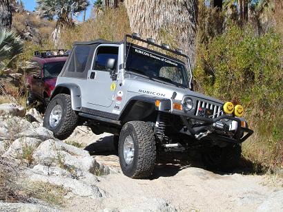
That's one long hike. My wife and our 2 Chihuahuas are inside of the Jeep...
|
|
|
David K
Honored Nomad
Posts: 64476
Registered: 8-30-2002
Location: San Diego County
Member Is Offline
Mood: Have Baja Fever
|
|
Congratulations El C. Loco!
It is a great place (Mision Santa Maria)... and although my son and I only got 2/3 the way to the mission on the Camino Real, it was a great hike.
John M., El C. Loco hiked up to the mission on the (post Junipero Serra) El Camino Real which stays high above the Santa Maria canyon, drops down to
meet the bulldozed road near the point you park and hike to see the petros and Indian trail a mile and a half east of the mission.
His group returned via the WET Santa Maria canyon... See Don Jorge's web site which details this: http://www.southcoastfarms.com/gonzaga_to_mission_santa_mari...
[Edited on 3-7-2006 by David K]
|
|
|
TMW
Select Nomad
Posts: 10659
Registered: 9-1-2003
Location: Bakersfield, CA
Member Is Offline
|
|
Congratulation on accomplishing something you can be very proud of.
|
|
|
Barry A.
Select Nomad
Posts: 10007
Registered: 11-30-2003
Location: Redding, Northern CA
Member Is Offline
Mood: optimistic
|
|
El Comandante--------------
Well done.
I have wanted to do that hike for years, and now you have gone and done it. I am very envious!!
Barry
|
|
|
Neal Johns
Super Nomad
Posts: 1687
Registered: 10-31-2002
Location: Lytle Creek, CA
Member Is Offline
Mood: In love!
|
|
Good dog!
I have waited too long to hike up to the Mission, may hike down someday.
My motto:
Never let a Dragon pass by without pulling its tail!
|
|
|
David K
Honored Nomad
Posts: 64476
Registered: 8-30-2002
Location: San Diego County
Member Is Offline
Mood: Have Baja Fever
|
|
El C. Loco, do you have photos???
Here are a couple of mine from that hike...
Chris holding up the famous sign along the Camino Real:

Happy me on the mission trail. The trail head is way down in the arroyo far behind me:

First boojum tree west of Gonzaga on the Camino Real:

Chris wants to head on. This is where we lost the trail:

|
|
|
El Comadante Loco
Nomad
Posts: 274
Registered: 6-12-2004
Member Is Offline
|
|
David.. We do have photos but I am wating for Ricahrd to e-mail them to me. As soon as he does I will post some. I think we have one photo of the
same boojum tree....
|
|
|
David K
Honored Nomad
Posts: 64476
Registered: 8-30-2002
Location: San Diego County
Member Is Offline
Mood: Have Baja Fever
|
|
Yes, when coming up from the non-boojum area near Gonzaga, it is pretty cool to see... Let's you know you are getting closer to Catavi?a!
|
|
|
BAJACAT
Ultra Nomad
Posts: 2902
Registered: 11-21-2005
Location: NATIONAL CITY, CA
Member Is Offline
|
|
Great report will wait for photos, congratulations on accomplishing your goal..
BAJA IS WHAT YOU WANTED TO BE, FUN,DANGEROUS,INCREDIBLE, REMOTE, EXOTIC..JUST GO AND HAVE FUN.....
|
|
|
David K
Honored Nomad
Posts: 64476
Registered: 8-30-2002
Location: San Diego County
Member Is Offline
Mood: Have Baja Fever
|
|
11 Years Later...
Quote: Originally posted by El Comadante Loco  | | David.. We do have photos but I am wating for Ricahrd to e-mail them to me. As soon as he does I will post some. I think we have one photo of the
same boojum tree.... |
Hey Rudy, still waiting to see the photos! 
|
|
|
StuckSucks
Super Nomad
Posts: 2305
Registered: 10-17-2013
Member Is Offline
|
|
Does anyone have a map of the trail?
|
|
|
David K
Honored Nomad
Posts: 64476
Registered: 8-30-2002
Location: San Diego County
Member Is Offline
Mood: Have Baja Fever
|
|
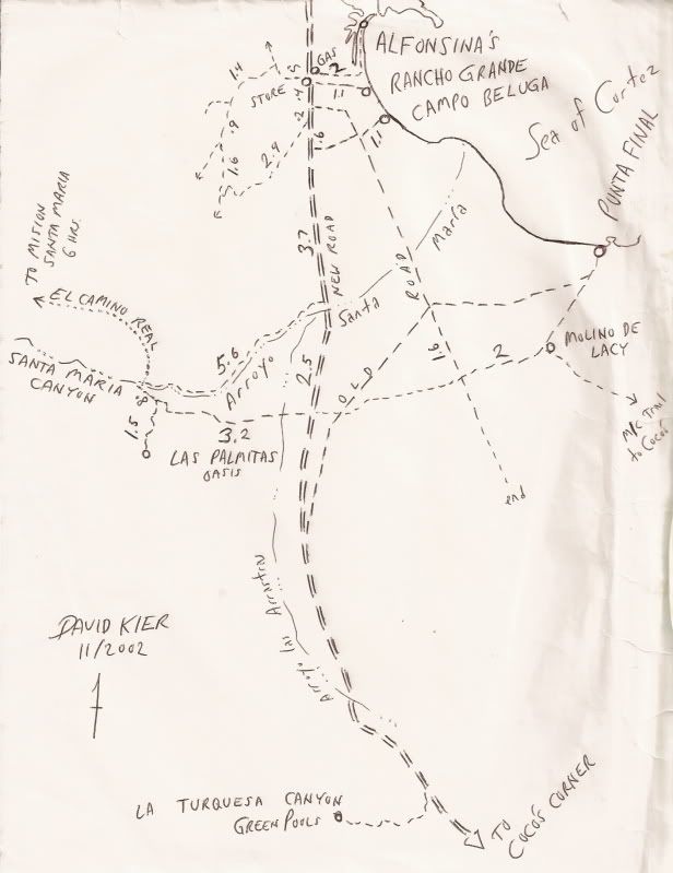
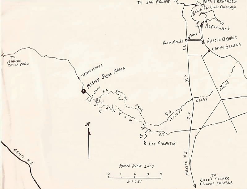
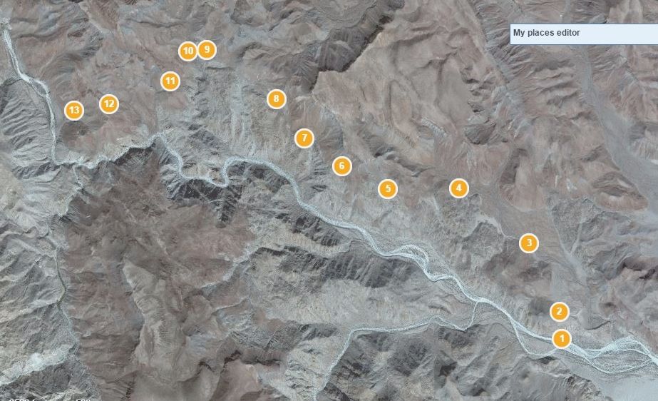
Is that a trick question? 
I even have kmz or whatever it is called for Google Earth!
Here are a couple of my sketch maps to show you where it is:
|
|
|
StuckSucks
Super Nomad
Posts: 2305
Registered: 10-17-2013
Member Is Offline
|
|
Thanks David! I found the trail on sat views - looks like you can drive in from the east for a while before it's boots on ground. Looks like many
palms in Arroyo Sta Maria. Added to my bucket list.
|
|
|
David K
Honored Nomad
Posts: 64476
Registered: 8-30-2002
Location: San Diego County
Member Is Offline
Mood: Have Baja Fever
|
|
You can drive to where the trail climbs out of Arroyo Santa Maria on the north bank. Just a little further into the canyon, boulders and shrubs block
vehicles. I sent you a u2u.
|
|
|
StuckSucks
Super Nomad
Posts: 2305
Registered: 10-17-2013
Member Is Offline
|
|
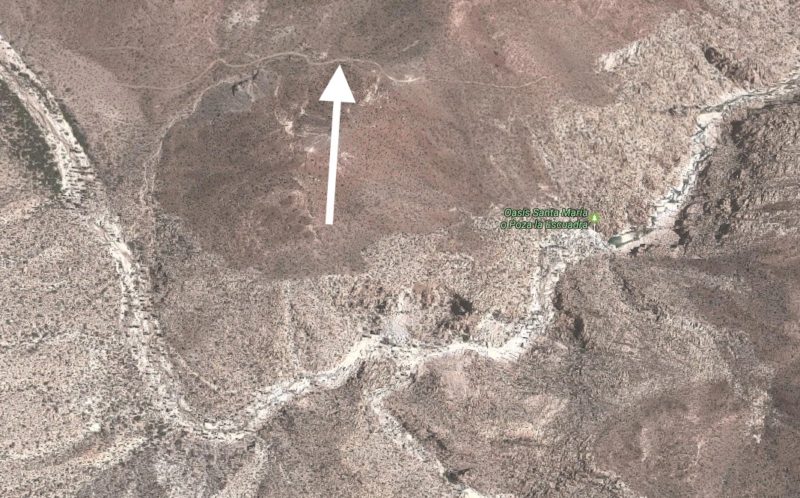
| Quote: Originally posted by David K | | You can drive to where the trail climbs out of Arroyo Santa Maria on the north bank. Just a little further into the canyon, boulders and shrubs block
vehicles. I sent you a u2u. |
This is the trail of which you speak?
|
|
|
David K
Honored Nomad
Posts: 64476
Registered: 8-30-2002
Location: San Diego County
Member Is Offline
Mood: Have Baja Fever
|
|
No.
That is the bulldozed road to the top of the ridge where Fred Hampe abandoned the road building project to connect Santa Ynez to Punta Final. However,
just past the ridge top, you can see the foot trail drop down to the canyon below... This was the Camino Real pre-1768 when the Jesuits used the
canyon. Once Serra got to Santa Maria on his trek to San Diego in 1769, he ordered a better route (safer for mules) be built and that is the trail of
my map. It stays out of the canyon and up along the north ridge, or close.
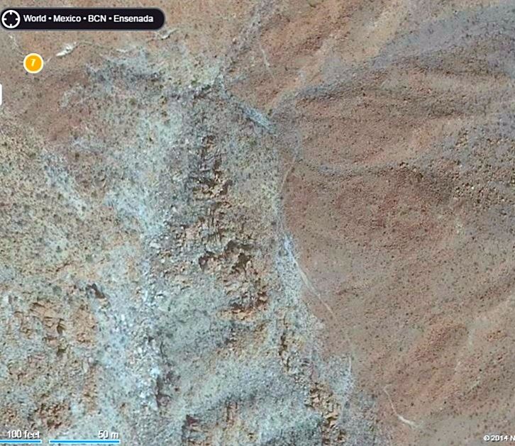
Just above your close-up:
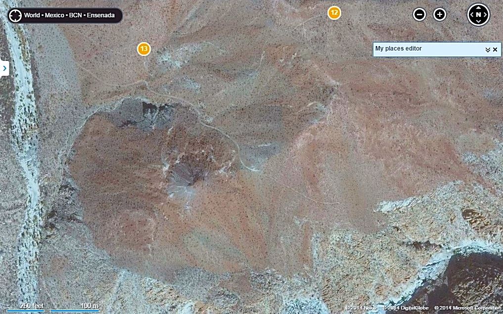
Close up, near #7:
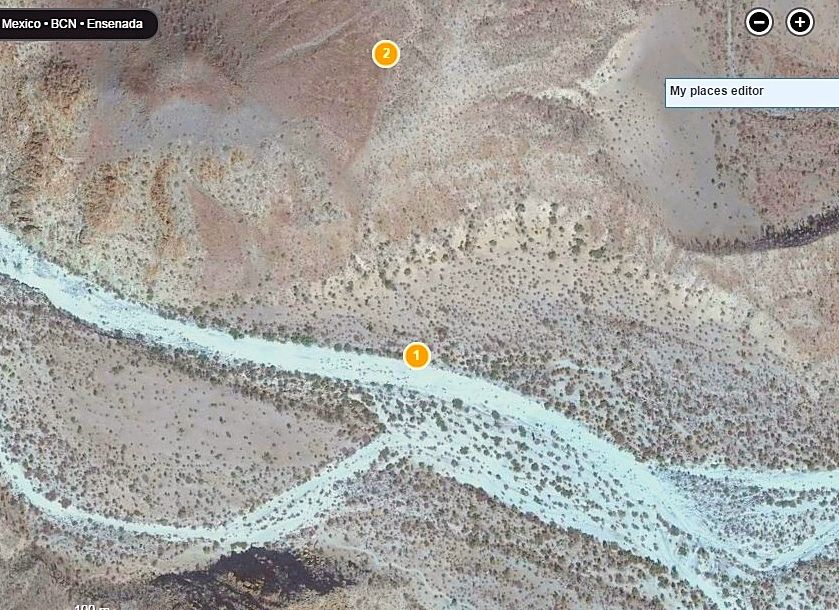
Where to find it at the point it climbs out of the sandy Arroyo Santa Maria (#1)... just outside the canyon entrance. ..
[Edited on 5-18-2017 by David K]
|
|
|
David K
Honored Nomad
Posts: 64476
Registered: 8-30-2002
Location: San Diego County
Member Is Offline
Mood: Have Baja Fever
|
|
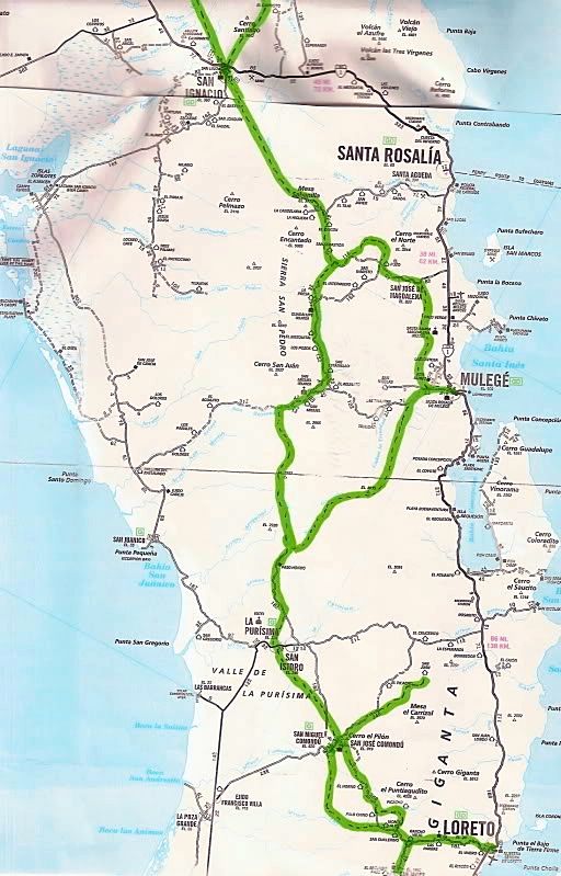
El Camino Real on AAA Map
The full Jesuit (1697-1768) road network is quite extensive, the main El Camino Real was just one of their roads.
Nomad '4x4abc' is right now in central Baja researching other mission roads.
Here are the main El Camino Real routes between Loreto and Santa Maria drawn on the AAA map. See where modern roads cross or even lay over the mission
road:
Loreto to San Ignacio:
San Ignacio to San Borja:
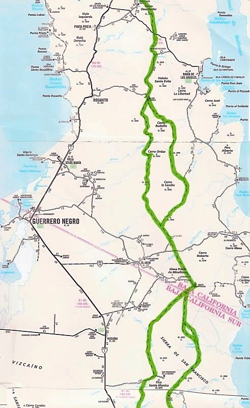
San Borja to Santa Maria:
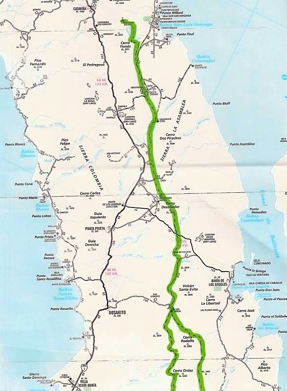
Highway 5 construction is right on the Camino Real, south of Gonzaga where the pavement ends to just south of Coco's Corner.
|
|
|
| Pages:
1
2 |


