| Pages:
1
2
3
..
5 |
Sharksbaja
Elite Nomad

Posts: 5814
Registered: 9-7-2004
Location: Newport, Mulege B.C.S.
Member Is Offline
|
|
Old Road Remembered
I always have flash-backs when I drive the highway now known as Hwy 1.
Sometimes I swear I can look over at the "old road" where it is visible and actually remember being on that particular stretch of the route.
Not only that but I sometimes just because of some nostalgic whim, I'll pull off and venture a ways on the "old road". It is so cool that it still
exists. I remember when CA had dirt tracks too!
Some of the more memorable parts of the the trip still tingle the spine when I remember how tough those places were to navigate.
Catavina, the grade souith of Mulege, Bahia de Concepcion and places in between still hold my thoughts today as I race thru and conjure up the
adrenaline that we felt so many years ago.
THAT'S WHAT I'M TALKIN' HERE, MAN!
You can still do it!
LOOK over there see that little crumbly narrow pair of paths? Scoot on over there and see where it goes. You might be SO surprised! Really , check out
the "old road" if you can. It holds plenty from the past.
I'd be curious to know if someone has followed and traversed the passable route as it is today and documented it?
[Edited on 4-15-2006 by Sharksbaja]
DON\'T SQUINT! Give yer eyes a break!
Try holding down [control] key and toggle the [+ and -] keys
Viva Mulege!
Nomads\' Sunsets
|
|
|
bajalera
Super Nomad
Posts: 1875
Registered: 10-15-2003
Location: Santa Maria CA
Member Is Offline
|
|
Ah, Sharks, you've stirred up fond memories--looking at that narrow slash in the vegetation trailing off into the distance in the morning, and knowing
you'd get about as far as you could see at the end of the day. If everything went well, that is.
We usually take the Old Road through the granite-boulder area that has the Virgin's shrine where the old man lived, and have made side trips to find
Turquesa Grade and several other old landmarks.
If the Mexican government had asked for my advice, it would have put Highway One somewhere else, kept the Old Road as a toll road, furnished gas
refrigerators to ranchers who wanted to stay put and sell cold drinks, and presented Conquistador de la Carretera plaques to people who made it to La
Paz.
I'd have paid to still be able to drive on it. And like you, I wonder if anybody has tried to piece the viable sections together.
\"Very few things happen at the right time, and the rest never happen at all. The conscientious historian will correct these defects.\" -
Mark Twain
|
|
|
David K
Honored Nomad
Posts: 64476
Registered: 8-30-2002
Location: San Diego County
Member Is Offline
Mood: Have Baja Fever
|
|
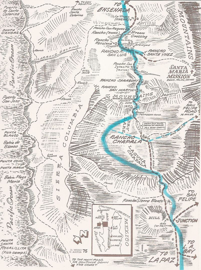
Where is that old Baja road, you ask?
From a posted reply to Surfer Jim in Dec. 2004:
Where is that old Baja road, you ask?
I am refering to the pre-December, 1973 Baja main road. Everything changed after December 1973 as far as Baja travel and number of visitors.
I was just a kid when my folks and I drove to the tip in 1966 in our Jeep Wagoneer. But, I was already infected with Baja Fever and my favorite book
was Gerhard & Guilick's LOWER CALIFORNIA GUIDEBOOK (The Baja Bible). We went to Gonzaga the year before and to L.A. Bay the following year. The
next trip down Baja (to Loreto) was in July, 1973. The highway was under construction and I took many notes and milages as to its location compared
with the old road. That July, pavement ended near Mision San Fernando (near El Progreso) and didn't start again until near Punta Prieta (in sections)
with solid pavement starting about Villa Jesus Maria. We were on the old road from Agua Dulce (10 miles beyond San Agustin) to almost Laguna Chapala.
The old road locator:
Just past where the highway crosses Arroyo El Rosario is where the old road left the valley using a side canyon, that the new road stays above, just
west.
The old road crosses the new and parallels it to the south, Rancho Aguajito and the turquoise mines are along it.
El Progreso was moved north a half mile to the highway from the old road.
The road left to Rancho Penjamo is along the old road, as is Aguila and Guayaquil.
The abandoned Pemex and trailer park 'San Agustin' is a half mile south of the original San Agustin, on the old road, as is Cafe Sonora a couple miles
ahead.
Agua Dulce is off the old road, a couple miles to the left of Km. 157. The old road stays about 1-2 miles east/left of the highway in the La Virgen
boulder area. The old road rejoins the highway just before the palapa by the rock art cave, 2 miles before Catavina.
The highway is next to the old road past San Martin and over to the first little dry lake. At the Pedregroso boulder mountain, the old road went
around the west side, whereas the new highway goes around the east side.
At the first sight of the Laguna Chapala valley, the old road continued straight towards the old ranch site, along a little hill just north of the dry
lake bed. This section before the ranch was perhaps the worst in all of the Baja road... deep, fine powder Baja dust that would cover your vehicle
completely. You would drive blind after fixing onto the trees by Rancho Chapala and hoping for the best! Then, after the ranch, you got to open it up
and drive 60 mph on the dry lake to blow a lot of that dust off. That best of the old road only lasted a couple miles, however. That Chapala dust
would stay with the Jeep for many car washes over the following years!
The new highway stays to the right of the dust field, along the hill, and to the right (west) of the dry lake. Rancho Chapala moved to the highway and
was renamed Nuevo Chapala. The new Chapala to Puerto Calamajue, then on to Gonzaga and San Felipe road was built from from about 1982-87. Coco started
his corner after that first section was built.
Both old and new roads come together where you leave the Chapala valley and see that beautiful view of the desert and mountains to the south.
Beyond El Crucero (where the road turns from southeast to south at the base of a hill) both roads are together. In a few miles the old road goes off
to the right (west) of the new and parallels it to Punta Prieta.
At Rosarito, the new highway swings west down the arroyo a couple miles then turns south to Guerrero Negro. The old main road went straight south from
Rosarito and eventually went to the center of the peninsula at El Arco. Some truckers running supplies to the new town of Guerrero Negro went along
the 'coast route', then took desert trails on to San Ignacio. The new highway does the same, passing near Guerrero Negro then swinging to the
southeast for San Ignacio. The old road coming south from El Arco joins the new near Vizcaino (a new town since the highway was built).
Vizcaino to San Ignacio finds both routes near each other. San Ignacio to Mulege, the same.
Along Bahia Concepcion, the old road can be seen in the cliff, right above the water in many places. This was built and maintained by the prisioners
of the old territorial prison in Mulege (closed after the highway was built ending the isolation).
Just south of Bahia Concepcion, the old main road went inland via Comondu where today's highway goes south through Loreto. Both rejoin at Insurgentes.
Travelers to Loreto could get to La Paz by driving to San Javier and then on to Santo Domingo on the main road. The road south of Loreto ended at
Ligui.
Pavement in '66 began about 100 miles north of La Paz and ended again, about 10 miles south of La Paz. They were building the new road and we drove on
it (unpaved) until past San Bartolo. It was just a two track jeep trail from there to Cabo San Lucas! The new highway stays to the east of Santiago
and Miraflores, where the old road naturally went right through these pretty villages...
I hope some of you find this a bit interesting... thank you for allowing me to share from my childhood memories and later observations!
|
|
|
David K
Honored Nomad
Posts: 64476
Registered: 8-30-2002
Location: San Diego County
Member Is Offline
Mood: Have Baja Fever
|
|
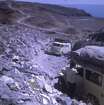
Here is the old main transpeninsular road, looking south, just south of Agua Dulce (between San Agustin and Catavi?a). The new highway is 1.4 miles
west (between Kms. 160-161)... My truck is on that access road where it meets the old main road.

|
|
|
Sharksbaja
Elite Nomad
Posts: 5814
Registered: 9-7-2004
Location: Newport, Mulege B.C.S.
Member Is Offline
|
|
Thank David. What, no map!!???
DON\'T SQUINT! Give yer eyes a break!
Try holding down [control] key and toggle the [+ and -] keys
Viva Mulege!
Nomads\' Sunsets
|
|
|
BOLABOUND
Junior Nomad
Posts: 61
Registered: 1-25-2006
Member Is Offline
Mood: wish I was lost in deep BAJA
|
|
Cool David,
Glad someone knows the real stuff.....
|
|
|
surfer jim
Super Nomad
Posts: 1891
Registered: 8-29-2003
Location: high desert
Member Is Offline
|
|
I drove the old ROUTE 66 back in the day from Chicago to L.A.....to come to Cali to surf......but missed the origional BAJA road by a few
years...surfing at that time in the Rosarito area...K39, K55, RAUL'S, CUATRO CASAS, K181...no need to go further south then as it was the " edge of
the known world" as far as we knew.....
|
|
|
vacaenbaja
Senior Nomad
Posts: 640
Registered: 4-4-2006
Member Is Offline
|
|
For those of you who long for a little flavor of the old road circa 1920 try this read " Long walk to Mulege" by Hale I believe. Talks of alot of
the old
landmarks and name places that now exisit and no longer exist.
I have always wondered if David K could with all his knowledge and resources map out the route that the two adventures took on todays
Baja Almanac Map (Baja Norte, Baja Sur ) .
|
|
|
Neal Johns
Super Nomad
Posts: 1687
Registered: 10-31-2002
Location: Lytle Creek, CA
Member Is Offline
Mood: In love!
|
|
Million Dollar Wife! Why? See diary below:
Baja Road In 1967 - Christmas Vacation - Tijuana to La Paz
by Marian Johns
We're going to Baja! Never mind that the road isn't paved yet, gas is in 55 gallon drums, and it?s RAINING.
Cast of CHARACTERS:
Diarist: Marian Johns
Husband: Don Cox
Mama: Marian's mother
Dogs: Slipper, Suzy & Tanya
Vehicles: Jeep FC170 (forward cab)
Friends: Tricia and Tom Record with daughter, Sara, and Jack Baldwin (Land Rover)
12-16-67 - Sat. - Left LA about 9:30 a.m.. Drove to San Diego but phoned the Records first to say we'd go directly to border! Got to border about
11:30 and spent over an hour finding out that we can't get car permits here - can't get Jack's tourist card here- and no getting insurance for our
Jeep and his Land Rover. Drove to Ensenada, then to Maneadero where Jack got his tourist card. Drove till about 4:30 and camped under a grove of
beautiful oaks. It rained during the night - very cold. Jack got up and then someone looked at the time - 2:00 a.m. We went ahead with breakfast and
got going.
12-17-67 - Sun. - Pavement ended and road is muddy. About noon we came across a Corvair stuck in the mud. Pulled him out after about an hour of
messing around. He was going to La Paz but turned around. Continued on and ate lunch in some taller shrubs. Road pretty bad with mud, etc. Saw several
large trucks stuck - made a detour around them. Got into some strange territory with many detours around places where the road washed out. Then thru
some canyons and finally down a narrow spot and into the canyon to El Rosario - Camped along road before we got into town.
12-18-67 - Mon. - Jeep (ours) wouldn't start in the a.m. Starter seemed to be stuck and spring of gas pedal is gone. Fixed pedal and Jack pushed us
out of spot onto road - broke off his lock and strap of gas can so we put can in back of our Jeep. Got gas and water at El Rosario where a woman spoke
excellent English (Ed. note: Mama Espinoza is still there, age 100 in 2006). 2 red Jeeps passed us. We passed them later when they were stopped fixing
3 flat tires - said they ran over some cactus. About 4:00 p.m., we left the main road - after much discussing and headed for a spot near the coast
where ammonites have been found. Drove till dark and camped off the road - rain again. We put the doors of the tents together so the flaps would make
a roof.
12-19-67 - Tues. - Up early in the dark and rain and cold. Off at 7:00 Am. Didn't get too far when Tom Record decided not to go with us because of
cactus in the road so we went on - passed Santa Catarina -very bad road which isn't used much. We finally came to one of 3 bridges near the ammonite
site which was supposed to be after the second bridge. Mama's hand drawn map said "hill" instead of "mile" it turned out. We were looking for
buildings and got to the third bridge (too far). So back to the 2nd bridge, reread the map, discovered the mistake and saw a "hill?. Drove over to it
and sure enough ammonites all over the place. Looked around and took some broken pieces as there were no whole ones visible. It started to rain which
didn't help the road any. In fact it became a river in many places. Finally got back to Records at 1:00 p.m., then we all headed back to the main
road. A few hundred yards from the main road we got stuck in the mud and behind us a couple hundred feet, Jack got stuck. Records got stuck trying to
pull us out. Got the Records out, then went back to help Jack. Worked on his car until dark. Mama went to the houses at the main road and got them to
come with a truck which got stuck on its way to us. Decided to quit for the night and do it in the a.m. It finally stopped raining and we pitched the
tents, ate a cold stew dinner and went to bed.
12-20-67 - Wed. - Up about 6:30, got Jack's LR out fairly soon and then worked on the Jeep. The fellow with the stuck truck came and got that out and
then came over and helped us get the Jeep out - ate breakfast. Don got the Jeep stuck a few feet away from the hole he'd just been in. Got him out of
that and onto a hard spot. Finally got going about 11:00 a.m., filled up with gas at San Agustin and then off - made 50 miles when Jack got stuck in
mud. Records drove off on side of road and pulled him out up to the place they were. Then they got stuck and he got stuck again! So Don got the Jeep
and drove on to hard ground and, with chains put together and Jeep on boards, we pulled them both out. A Jeep Wagoneer passed us. (Earlier we had to
ford a large steam and at a smaller one tried to pull out a large truck which had been stuck 8 days. The owner had emptied his truck of its cargo
because rains caused the streams to rise higher than the truck bed. We couldn't budge him, so went on.) We went on only a little way after un-
stucking everybody and camped.
12-21-67 - Thurs. - Up at 5:00 a.m. and off at 7:00. Passed camped Wagoneer - Road very bad - muddy grades. Passed one truck with axle torn out. Came
to Laguna Seca which is wet now - one stuck truck and one flat on the Land Rover. Changed that and drove on only to find a stuck car. Two U.S. fellows
were trying to pull them out with their Dodge panel wagon but couldn't. So we found a way around and Jack pulled the car up to the top of a dry hill -
Then we left even though there was another car (unstuck) to get thru. Got to Laguna Chapala - got gas and drove on. Stopped shortly though as it was
lunch time. Don discovered that we had a broken spring. Could only tighten down U bolts. Road is becoming better and really nice where the Gulf Coast
comes in. Drove on a few miles past that and camped. Wind is atrocious. The pole in Records tent wouldn't have lasted, so they decided to fill tent
with stuff from their Jeep, let the tent down and sleep in their Jeep. Mama decided to sleep in the Land Rover. Jack decided to sleep in our tent (let
down) and Don and I slept in the bed of our Jeep. It was warm, but the rattling tarp over us kept me awake several hours.
12-22-67 - Fri. - Got up and wind is still as bad so decided to go on without breakfast. Drove on to Punta Prieta - road is still pretty muddy. Got
gas at Punta Prieta. Jack's car isn't charging - found out that a brush was stuck. Ate a lunch of sandwiches and drove on, but not far, as the brake
drum broke from the hub on our Jeep - Can't go any further. Don and Jack decided to drive back to Laguna Chapala to have it welded. This was all
decided after they drove down the road a ways to a place where there was supposed to be a welder, but there wasn't one that would work. They found out
that they could get welding rods in Punta Prieta in case they didn't have them in Laguna Chapala. Found out our sleeping bags (Don's and mine) were
wet. Had to dry them out before night. Got them mostly dry - good enough to sleep in. Put up tent since there is no wind tonight.
12-23-67 - Sat. - Waited for Jack and Don to get back. I read Don's book Sea of Cortez. Mama re-did her hair. They finally got back round 5:00 p.m.,
then they had to pound off some of the welds because it wouldn't fit. We decided to eat an early dinner before we left so we wouldn't have to stop
again. Got everything ready and drove on. Only got about two or three miles further when the wheel broke again. Limped on a few hundred feet to get
out of the mud and stopped for the night. How depressing!!! Mama fell into the little wash by camp but didn't hurt herself. It drizzled all night.
12-24-67-Sun. - Cold, wet morning. Don decided to try and make a thing to hold the wheel together. Cooked breakfast in the tent while they worked on
the wheel. Then a caravan of trucks came by. Told them of our plight and they offered for $80 (finally $70) to take off one of their little pickups
which was riding piggy back and put ours on and take it to La Paz - We agreed on the condition that that if we found another wheel on the way we could
get off. They shoveled out the wash so they could drive the big truck up and unload their pick-up and load ours. All went well but the bank gave way
under the Jeep's left front wheel. Luckily the 3 others were already on the truck so they jacked it up high enough to get a board under that wheel.
Finally got it on with a lot of elbow grease - shoving it into place. After they tied it down, we left - slowly. We stopped for lunch while they drove
on. Caught up with them where 2 big trucks were stuck. They had a big unstuck one so we went on. We drove on ahead because they were going so slowly.
Waited in a little town (Rosarito) where we got gas and Mama gave Xmas candy to kids. We drove on ahead again in the dark since these men drive until
10:00 or 11:00 p.m. Stopped in next town for dinner while the trucks all caught up. After we ate, Don stuffed the pinata he bought in Tijuana for
Sara. Then we put it on a pole which one of the drivers held sitting high up on our Jeep. The children there came out and had their try at breaking
the pinata. Finally got the driver of the truck with our truck to try and he broke it. All the kids got plenty of candy. Drove on till 10:00 p.m. and
stopped for the night with the trucks. (There are 6 of their vehicles and 2 of ours) They had been at Laguna Chapala when Don and Jack had welded the
wheel (One guy had tried to weld without a mask and hurt his eyes so he's wearing dark glasses.) Slept without the tent since the night was so
pleasant.
12-25-67 - Mon. - Christmas morning - our sleeping bags are wet from the dew ? but not clear through. The truck carrying our truck ruined a tire the
night before so they took off the dual on the other side and are using singles now - This way the driver goes extra slow. We went on ahead - Don rode
in the Jeep on the truck. We stopped and waited in Mezquital. It took them an hour and 1/2 to catch up. That noon at Rio Grande they put tires on the
duals so they had 4 again. We went on ahead to El Arco where we got gas and then drove on to Los Martires - in the dark part way Met a fellow there
who had driven down and was driving back, taking plenty of time. Said the road to Santa Rosalia was washed out. That was the way we had planned to go
but after his news, decided to go down the Pacific coast road.
12-26-67 - Tues. - Went to San Ignacio which was very pretty - date palms all over - a river and beautiful mission. Stayed there over an hour and went
on over rough rocky roads - passed several other "palm-oasis". Stopped for a late lunch and then had to ford several large clear streams. (Don't think
they're year-round though) About sundown Jack hit a high rock and pushed a frame member up against the transmission - so it had a different angle and
caused a noticeable vibration. Also a motor mount broke. Don suggested putting in a piece of wood and that helped some - at least we were able to
drive on. Drove in to night and took a wrong turn somewhere and before we knew had driven out on a muddy tidal flat and got the Land Rover stuck.
Finally got it out - using chains. Drove it out the way it came in. While "unstucking" him we saw lights several times back the way we had come and
thought that perhaps the trucks (even our caravan) was going the right way. So we drove back and met 2 trucks - one of which was stuck. We had met
them in the afternoon when they were again stopped - blocking our way. They said they thought we were on the right road - we'd see in the a.m. when
there was light. So we camped right there in the road for the night. They had evidently been the lights we saw earlier.
12-27-67 - Wed. - Lent a chain to the stuck truck. Ate breakfast while they used the chain to get their truck out. Then we left all together, but we
soon left them because they were going slower. Found the right road and drove around the salt flat that the night before we tried to go thru. Made
good time - nice day, but ran low on gas. Had to cross several more full clear streams - but don't look like they run all year long. Got gas in a very
unusual town - Cadeje - with palms, a stream, and a neat clean town. They had trash barrels along the street - electricity and even streetlights. Ate
lunch by the stream and washed our feet - some of us. Crossed another big stream in arroyo south of La Purisima. Drove after dark and got to the
graded road. Stopped late in Santo Domingo. Got to bed about 12:00 midnight.
12-28-67 - Thurs. - The day the ferry leaves. Up at sun-up and off. Jack broke a fan belt - engine overheated - replaced it and off again. Got on the
pavement - How great! In La Paz shortly after 12:00 noon. Spent a while looking for the home of the chief of the caravan. Finally found it but they
hadn?t arrived yet. Went to get car papers but couldn?t get them - closing in five minutes and it will cost $16 later. Must get them at the boat now.
Drove out to ferry and waited about 1 hour till they opened after siesta. Found out we did have reservations, but our Jeep isn't here and Jack is
going to stay and have his Land Rover fixed. So we only need one place. Two UCLA boys grabbed at the chance to take one place since they hadn't made
reservations, and offered us (Mama and me) a place to ride to Los Angeles. Got Records car papers & tickets and said good-by to Don. Boat left at
5:15 p.m., not bad! (suppose to leave at 5:00). Records had to pay $l6 (US) to have car papers issued after hours (that being 1:00 p.m.!!!) I wanted
to take Slipper home, but Mama already asked if Suzy could go. The ferry had a cafeteria - so bought sandwiches for dinner.
12-29-67 - Fri. - Spend a miserable night trying to sleep sitting up. During the night some kid woke up crying for its mother. Many people slept on
the floor. It seems that first they sell tickets with seat numbers, and then tickets with no numbers. The ones without numbers have to sit and sleep
on the floor! Got a good breakfast for $1.00 - ham, eggs, cocoa and roll. Got to Mazatlan about 9:30 a.m. The bow of the ferry lifts up so vehicles
can go out that end. (They entered at the stern.) Had to wait a while for Record's Jeep and UCLA boys' VW. Ferry is supposed top hold 114 cars, but
most of the vehicles were large trucks. Of the people we saw on the way down, the 2 little red Jeeps and the green Jeep Wagoneer made it. An IH
carryall that we saw the third day wasn't there. Several parties, including the UCLA VW came the Gulf Coast route. Suzy didn't potty in the VW, but
did chew up the roof-liner of VW. How embarrassing. Mama will see if insurance will cover it when she gets home - otherwise will have to pay it out of
her pocket. (Dogs were not allowed with passengers.) Left Mazatlan about noon - Took wrong turn out of town and had to retrace several miles. Ate
lunch by roadside north of Tropic of Cancer monument. Got some tamales a kid was selling at a gas station for dinner. Decided to drive on cautiously
in the dark. The VW headlights are poor and aimed too low so let the Records lead after nearly hitting two horses. Records decided to quit about 12:00
midnight after seeing a head-on accident and nearly running off the road. We threw sleeping bags on the ground and we don?t have pads now so I put a
sweater under me to keep warm.
12-30-67 ? Sat. - Up with sun and had some instant breakfast. Stopped later in Santa Ana (Sonora) and had breakfast at a restaurant - huevos
rancheros, potatoes and a salad! Ate the salad in spite of warnings. Just outside of town the bridge was washed out - or something. At any rate
tractors were pulling cars across river for $4 (US) a whack! We thought we could connect the VW to the Jeep and then in case the VW couldn't make it,
the Jeep could help out. But wires got crossed or something and Tom said he didn't want to tow the VW. Then off he went across the river and left us
sitting. Jerry (owner of VW) and Jon decided maybe it would be best to go to Nogales. But Mama said she'd pay the $4. Then they got to thinking that
this river was no worse than some in Baja and that we should get out and wade across and push while Jerry drove. Had to push him in one place but got
across OK. I got my pants all wet and cut my foot. VW had a pool of water in the floor and my fuzzy boots were on the floor. A few opinionated words
were exchanged when we got to where Records were waiting. Finally the subject was dropped and on we went. Stopped one place for a bush and while
there, the battery in VW shorted out and started to burn through back seat. And at the same time Record's heater hose came unglued. Tom just joined
the hoses and by-passed the heater. Crossed border at Tecate with minimum of red tape - drove on to UCSD. Arrived there about 12:00 midnight and slept
on Record's floor.
12-31-67 - Sun. - Up about 7:00 and off silently without waking Tom and Tricia. Stopped by Santa Ana to get Studebaker so I can drive back Monday
night. Went on to Whittier and all had breakfast there. Slept all afternoon after a hot bath.
1-2-68 - Letters from Don in La Paz - First one says Jeep hasn't arrived. Second one says it has. He bought a used wheel. They've made arrangements
for the ferry, etc. etc.
Second one (I think the first part is a joke) says:
Dear Marian,
The road to the north is washed out, the ferry sank, and the airplane service has been discontinued until the end of the current international
revolution. Consequently, I and our 7-ton truck will probably be home in about 41 days. (Ever try to write a letter in a shimmying Land Rover?) Mas
dificil. We have reservations on Sunday's boat, got money from traveler's checks, Land Rover will be worked on tomorrow morning at Willys agency. Our
Jeep hasn't arrived here as yet but we apologized to the customs officials who turned out to be quite nice fellows and issued our import permit
without the Jeep! We had to have it to confirm our reservation.
Tanya and Slipper are shipshape, Jack's in a much better mood; we burned our guts over a chicken enchilada dinner last night. Sunday night is New
Year's Eve by our reckoning so we expect a good time on board the ferry Jack will leave without me if our truck does not arrive. Hope your sailing was
good and things are OK in VW land as I write this. Jack says he's sorry he scared you to death yesterday. Love you muchly, Don
Dec. 30
Hi - Jeep arrived this a.m. They ran out of gas up the road a piece and had to borrow money - delayed a few hours. One pickup with our gas cans and
chains has not yet arrived. We've not yet paid. Bought a used wheel ($20) and Jack had his frame member removed, straightened, and rewelded in place,
his front springs tightened, and a crack in his gas tank mended for $13. Very cheap, no? Will be on ferry OK. Dogs are OK. Made customs office today
with only two minutes to spare, drove our truck off the other truck (after installing newly acquired brake drum in double quick fashion) and straight
to aduana. Did a day's work in 45 min. Now we rest and wait. See you soon, Love, Don
My motto:
Never let a Dragon pass by without pulling its tail!
|
|
|
Sharksbaja
Elite Nomad
Posts: 5814
Registered: 9-7-2004
Location: Newport, Mulege B.C.S.
Member Is Offline
|
|
Thanks Neal, quite a story! Surprised you ever went back.
David, That website is quite the effort.
Maybe it's time you, Neal and some others put it all together in the form of a guide. I'd buy one.
DON\'T SQUINT! Give yer eyes a break!
Try holding down [control] key and toggle the [+ and -] keys
Viva Mulege!
Nomads\' Sunsets
|
|
|
David K
Honored Nomad
Posts: 64476
Registered: 8-30-2002
Location: San Diego County
Member Is Offline
Mood: Have Baja Fever
|
|
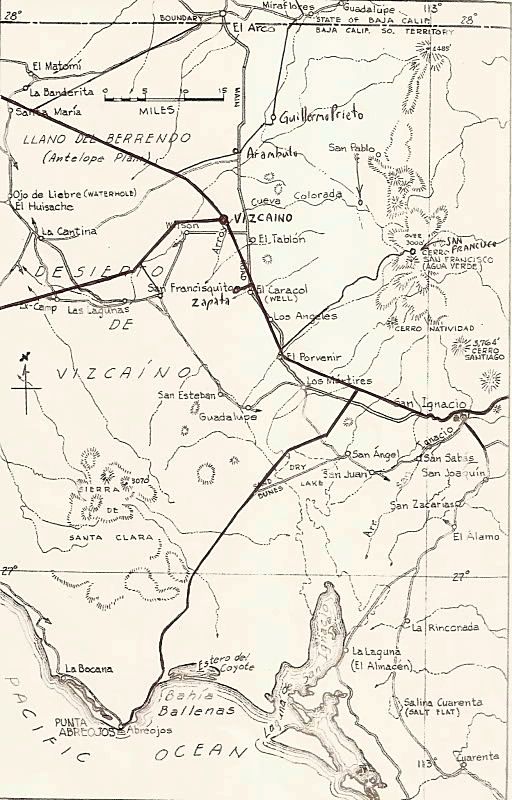
The maps from the 1962 Lower California Guidebook are available to view here: http://biology.fullerton.edu/biol517dje/maps/baja_1962.html
Click on a place on the peninsula map to view the detail map of that area...
[Edited on 4-17-2006 by David K]
|
|
|
David K
Honored Nomad
Posts: 64476
Registered: 8-30-2002
Location: San Diego County
Member Is Offline
Mood: Have Baja Fever
|
|
Bump a good thread from 2006!
|
|
|
Sharksbaja
Elite Nomad
Posts: 5814
Registered: 9-7-2004
Location: Newport, Mulege B.C.S.
Member Is Offline
|
|

DON\'T SQUINT! Give yer eyes a break!
Try holding down [control] key and toggle the [+ and -] keys
Viva Mulege!
Nomads\' Sunsets
|
|
|
JZ
Elite Nomad
Posts: 9215
Registered: 10-3-2003
Member Is Offline
|
|
Loved Neal's report. Crazy.
We did Mexicali, Gonzaga, Cocos, BoLA, San Francisquito, El Arco, on to Santa Rosalia, ferry over to Guaymas, up to Santa Ana, and back to LA in
December. About 300 miles of it in the dirt only though. Put my truck in a big truck on the ferry as there was no other room.
I want to do the whole thing in the dirt to La Paz and then over to the mainland within the next year.
|
|
|
chuckie
Elite Nomad
Posts: 6082
Registered: 2-20-2012
Location: Kansas Prairies
Member Is Offline
Mood: Weary
|
|
Great Narrative Neal!! Thanks...
|
|
|
mtgoat666
Select Nomad
Posts: 17280
Registered: 9-16-2006
Location: San Diego
Member Is Offline
Mood: Hot n spicy
|
|
Would be out useful if the explorers posted kml/Kmz files (or other gps line work) of the old road and camino real. PDF and jpg files of maps are not
really useful to many in this modern age of gps.
|
|
|
Russ
Elite Nomad
Posts: 6741
Registered: 7-4-2004
Location: Punta Chivato
Member Is Offline
|
|
My '68 adventure
Bahia Concepcion where life starts...given a chance!
|
|
|
David K
Honored Nomad
Posts: 64476
Registered: 8-30-2002
Location: San Diego County
Member Is Offline
Mood: Have Baja Fever
|
|
Wow, we arose Sharksbaja! Hi Corky!
Goat, more and more of the 'Old Road' is no longer passable. Often now as it is fenced across ranches and farms and where it isn't being used anymore,
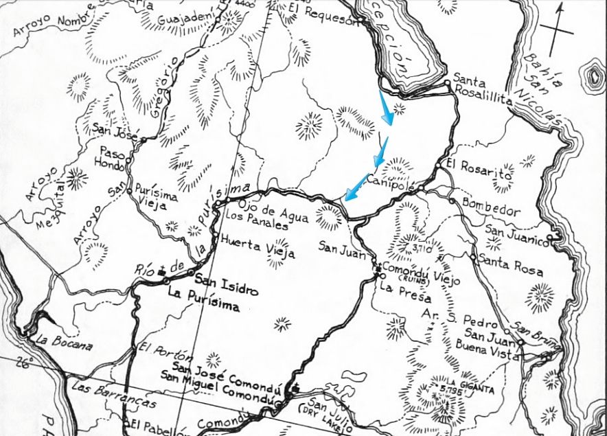
it is washed out from erosion or lack of maintenance. I have posted old road maps with the new highway penciled in to show their relationship... see
below...
Russ, cool photo of the 'Gonzaga Grades' south of Puertecitos.
The solid line drawn in is the highway in relation to the main road, here on Gulick's 1962-1970 maps:
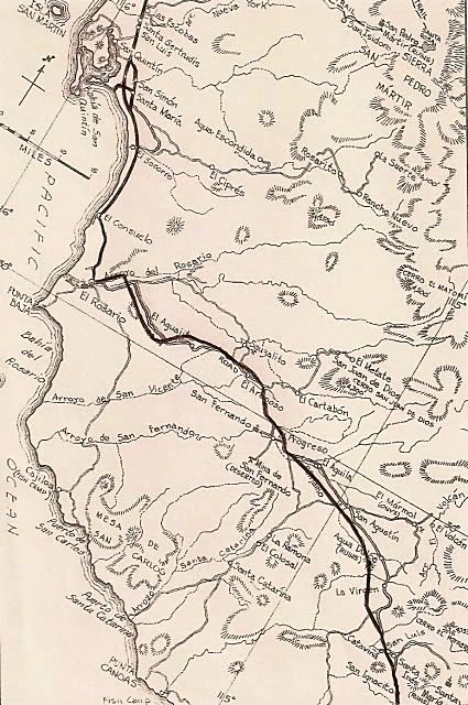
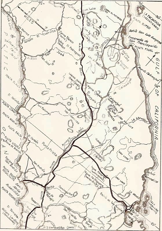
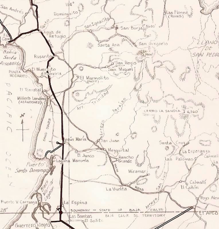
South of Bahía Concepción, the main road to La Paz went through Comondú and not Loreto before the new highway grading was in by 1971. The blue
arrows show the route of a newer shortcut to Comondú or La Purísima that was open by 1966, we drove it that year.
Cliff Cross published a very popular Baja guide in 1970, with 1972 and 1974 revised editions. His maps were more of a 'bird's eye view' and many
people liked them. When he revised the maps to show the new highway, sadly he placed it incorrectly in some places (as did Mike McMahan on the popular
wall maps post-1974).
Here, I take Cliff Cross's great maps and add in the new highway more accurately compared to where he shows the old road:
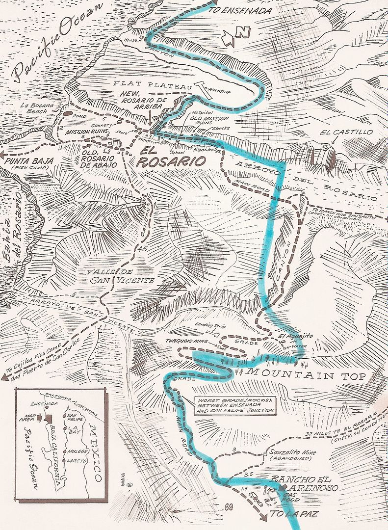
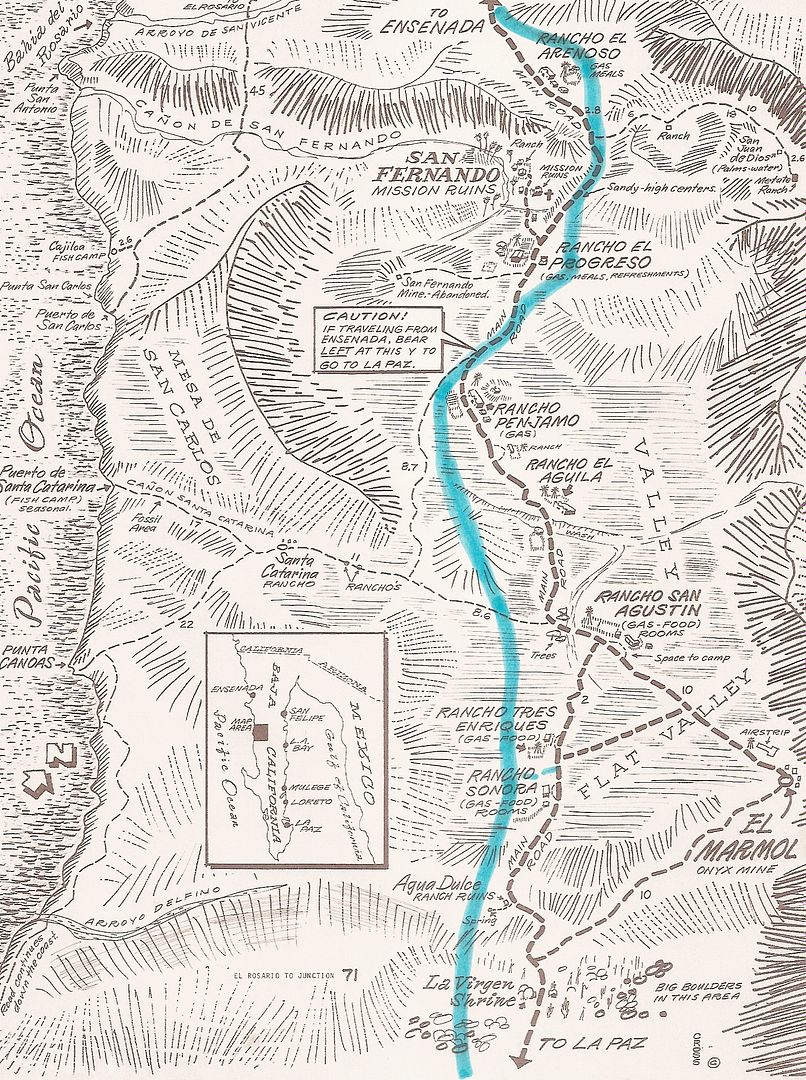
I have also posted Google Earth maps showing the old road alongside Highway 1 south of El Rosario.
|
|
|
chuckie
Elite Nomad
Posts: 6082
Registered: 2-20-2012
Location: Kansas Prairies
Member Is Offline
Mood: Weary
|
|
KOOL stuff...
|
|
|
bonanza bucko
Senior Nomad
Posts: 587
Registered: 8-31-2003
Location: San Diego
Member Is Offline
Mood: Airport Bum
|
|
The Old Road that was the MOST WORST was between Puertecitos and Gonzaga Bay. It used to take 4 to 5 hours to drive that 50 miles in a 4X4 truck. A
good dune buggy could make it faster than that.
It wasn't much better between Gonzaga Bay and Lake Challa past Coco's Corner.
The Tres Marias, three mountains about along the coast and high above the beach about 15 miles South of Puertecitos, had shrines at the bottom of the
grade so you could pray you would make it over the top.
There was a lath cross with a cowboy hat on it and "RIP Ray Grove" written on it at the top of the middle mountain of the Tres Marias; that was also
called Jim Bean Hill because the word was that Ray went over the side and down about 800 feet in the winter of 1975 or so. They found him in his old
truck with a bottle of Jim Beam in his boney hands. The truck is still down there.
If you ever drove that old road you will never forget it. I don't know why but I miss it. If you took your time and didn't really plan on getting to
Gonzaga Bay today it was nice :-)
The "paved" part of that road from San Felipe to Puertecitos was "better" but still lethal; the potholes occupied more of the road than did the
"pavement" and we used to dodge them by swerving from side to side into and out of our lane. Luckily there was almost no traffic. There were many
stops for Cerveza Pacifico along that road:-)
BB
BB
|
|
|
| Pages:
1
2
3
..
5 |
|


