David K
Honored Nomad

Posts: 64489
Registered: 8-30-2002
Location: San Diego County
Member Is Offline
Mood: Have Baja Fever
|
|
Guess where, Baja historic site!
Look closely... this is in a very difficult to reach location. Hints after each incorrect guess...

|
|
|
BajaVida
Senior Nomad
Posts: 541
Registered: 9-1-2003
Location: Motown, Califas
Member Is Offline
Mood: muy cool
|
|
the lost mission of Baja
No se apure y dure.
Don\'t hurry and you\'ll last longer.
|
|
|
Don Alley
Super Nomad
Posts: 1997
Registered: 12-4-2003
Location: Loreto
Member Is Offline
|
|
The lost Strawberry Fields.
|
|
|
David K
Honored Nomad
Posts: 64489
Registered: 8-30-2002
Location: San Diego County
Member Is Offline
Mood: Have Baja Fever
|
|
Okay, two dumb answers = 1 wrong answer... so a hint (and another photo, taken by Kevin in Ok)
HINT: This is NOT a mission, but has been called one by more than one historic author and INAH!

|
|
|
Don Alley
Super Nomad
Posts: 1997
Registered: 12-4-2003
Location: Loreto
Member Is Offline
|
|
Dumb answer? Darn, it was meant to be clever. And to elicit more hints. C'mon, David, two answers, even if dumb, should get two hints.
Pretty Please?
|
|
|
David K
Honored Nomad
Posts: 64489
Registered: 8-30-2002
Location: San Diego County
Member Is Offline
Mood: Have Baja Fever
|
|
Okay Don, I am sorry for calling your clever hint dumb!
Actually, west of Catavi?a there is a well watered area that would make good strawberry fields... but that belongs in Hook's thread on the M & M
Man!
Hint # 2 & 3: This site was mistaken for a mission because it resembles Mision Santa Maria de los Angeles so closely, but it was a VISITA (a
mission visiting outpost station) of another mission. This site CANNOT be reached by automobile and is on one of the routes of the El Camino Real
between Loreto and Alta California.
|
|
|
TMW
Select Nomad
Posts: 10659
Registered: 9-1-2003
Location: Bakersfield, CA
Member Is Offline
|
|
Santa Marta north of San Ignacio.
|
|
|
David K
Honored Nomad
Posts: 64489
Registered: 8-30-2002
Location: San Diego County
Member Is Offline
Mood: Have Baja Fever
|
|
Nope, but good one TW!
Hint # 4: It is in the state of Baja Calif. Sur.
|
|
|
David K
Honored Nomad
Posts: 64489
Registered: 8-30-2002
Location: San Diego County
Member Is Offline
Mood: Have Baja Fever
|
|
Any more guesses?
Hint #5, this was a visita of Mision Santa Gertrudis often mis named for another mission... one mission that is/was a mystery or 'lost', but probably
never existed seperately from Santa Gertrudis.
The photos (and answer) is in our Baja Missions web page at VivaBaja.com.
http://vivabaja.com/bajamissions contains photos or old illustrations provided by Jack Swords, Kevin in Oklahoma, academic-anachist, Ed Vernon,
and me of all the mission sites and many visitas in Baja California, along with dates and other brief details.
The best books on the missions are Ed Vernon's 'Las Misones Antiguas, The Spanish Missions of Baja California' and Dave Werschkul's 'Saints and Demons
in a Desert Wilderness'.
[Edited on 6-26-2006 by David K]
|
|
|
BajaVida
Senior Nomad
Posts: 541
Registered: 9-1-2003
Location: Motown, Califas
Member Is Offline
Mood: muy cool
|
|
David, your website may be down
I could not get to your website.
No se apure y dure.
Don\'t hurry and you\'ll last longer.
|
|
|
bajajudy
Elite Nomad
Posts: 6886
Registered: 10-4-2004
Location: San Jose del Cabo,BCS
Member Is Offline
|
|
Yo tampoco
|
|
|
David K
Honored Nomad
Posts: 64489
Registered: 8-30-2002
Location: San Diego County
Member Is Offline
Mood: Have Baja Fever
|
|
Thanks, I too tried to get to VivaBaja.com and couldn't this morning! My web host emailed me that his power was off this morning, and all is well
again well!
Do you want the answer now... or do you want to find the answer yourselves? http://vivabaja.com/bajamissions
There is a really interesting story on these seldom seen ruins that includes a chapter by Choral Pepper in her unpublished book 'BAJA: Missions,
Mysteries, Myths'
[Edited on 6-26-2006 by David K]
|
|
|
David K
Honored Nomad
Posts: 64489
Registered: 8-30-2002
Location: San Diego County
Member Is Offline
Mood: Have Baja Fever
|
|
The Answer (is within the following)
Here is the chapter on Mision Santa Gertrudis from the yet-to-be published BAJA: MYSTERIES, MISSION, MYTHS by the late Choral Pepper and edited with
revisions by Dr. Robert Jackson (academicanarchist on Baja Nomad)...
Santa Gertrudis (established 1752)
In 1728, the Jesuits established San Ignacio mission at an oasis on the southern edge of the Central Desert of Baja California. It would be more than
another two decades before the Jesuits established a mission north of San Ignacio. Attention shifted to the southern part of the Peninsula, where the
Jesuits established three missions in the 1730s: San Jose del Cabo (1730); Santa Rosa de las Palmas (1733); and San Luis Gonzaga (1737). One of the
difficulties encountered in establishing a mission north of San Ignacio was finding a site with adequate water and land for agriculture.
Fernando Konsag, S.J., operating from San Ignacio, did explore the southern sections of the Central Desert to find a site for a new mission, and in
the 1740s the Jesuits did have an endowment for the next establishment in the north that tentatively was designated Nuestra Senora de los Dolores del
Norte. Documents from the 1740s do cite the existence of Dolores del Norte, but the new mission only existed on paper. Nevertheless, the history of
Konsag?s Dolores del Norte has given rise to the myth of a ?lost mission.? However, no lost mission existed. Rather, Dolores del Norte was the
temporary name given to the next mission that the Jesuits did establish in 1752 with the name Santa Gertrudis.
Two reports from the mid-1740s provide additional details on the efforts to establish what eventually became Santa Gertrudis. The first is a report
written in 1744 by San Ignacio missionary Sebastian de Sistiaga,S.J.. Sistiaga noted that Dolores del Norte was an offshoot of San Ignacio formed from
?northern interior [indigenous] settlements.? Konsag had already baptized 548 Indians who would be assigned to the new mission, and the baptized
Indians themselves had begun to form new and larger villages in anticipation of the establishment of the new mission. To facilitate the process of
evangelization, Konsag brought young men to San Ignacio to be trained as catechists, and as future leaders of the new mission. The site tentatively
chosen for Dolores del Norte was dry and had a poor water supply, but no better site had been located. Finally, Sistiaga noted that the uncertainty of
the crops at San Ignacio had been one of the causes for the delay in the establishment of the mission. In a general report on the Baja California
missions, Visitor-General Juan Antonio Balthasar, S.J., noted that: ?This missions bit of property, incorporated with that of San Ignacio, will be
separated as soon as this mission is fully established.?
Konsag laid the foundations for the establishment of Santa Gertrudis in the 1740s. The surviving baptismal register for San Ignacio (1743-1749)
records the baptisms by Konsag of hundreds of Indians in the future territory of Santa Gertrudis. By 1751, when the Jesuits began to keep a separate
set a sacramental records for the new establishment, Konsag had baptized as many as 1,000 in the jurisdiction of Dolores del Norte/Santa Gertrudis.
Based upon the foundation laid by Konsag, the first missionary stationed at Santa Gertrudis, Jorge Retz, S.J., completed the baptism of the
non-Christian or gentile indigenous population within twelve years. In 1762, Jesuit Visitor-General Ignacio Lizasoain, S.J., noted that Retz had
already baptized 1,446 gentiles at Santa Gertrudis, and a total of 2059 baptisms.
Konsag never found a site for the new mission suitable for agriculture. Franciscan missionary Francisco Palou, O.F.M., wrote a concise description of
the site of Santa Gertrudis mission.
The mission is situated in a narrow valley, so that it was necessary to clear land by means of the crow-bar in order to construct a pueblo?It has
vineyards and orchards of figs, olives, pomegranates, and also some peaches. There is little land fit for sowing and water is scarce.
Because of the limited potential for agriculture, the missionaries only settled a small percentage of the neophyte population at the main mission
village. Palou further described the settlement pattern of the indigenous population under the jurisdiction of Santa Gertrudis.
Of all of these families only forty families live at the mission with one hundred and seventy-four souls. All the rest are scattered in seven
houseless rancherias which surround the mission proper in every direction, all looking for wild fruits and changing about according to the seasons.
A detailed census of the population of Santa Gertrudis prepared in 1773 as a part of the transition from Franciscan to Dominican administration of the
Peninsula missions confirms the dispersed settlement pattern (see Table 3.3). In addition to the cabecera (main mission village), the population of
Santa Gertrudis lived in eight additional rancherias. The most populous of the villages in the jurisdiction of Santa Gertrudis was Purificacion also
known as Kagin, with a total of 163 residents. In 1773, 141 lived at the main village. This settlement pattern has important implications for the
process of cultural and religious change. Even with the use of catechists and periodic religious instruction at the cabecera, the indigenous neophytes
living in the other eight villages probably received at best only a veneer of Christianity and European ways.
The Building of Santa Gertrudis:
As is often the case in the study of the Baja California missions, details on building construction at Santa Gertrudis are limited. First, however, I
would like to discuss several sites that have been identified as Dolores del Norte. An important architectural study published by INAH in 1991 assigns
the name Dolores del Norte to mission-era ruins at a location also known as San Pablo. The ruins at San Pablo consist of a single rectangular building
with three rooms, as well as a second structure. The authors of the report did not cite any evidence to substantiate the identification of San Pablo
as Dolores del Norte. A second location is San Francisco, near San Ignacio. There are extensive walls at San Francisco, but most appear to be corrals
and not buildings. Moreover, the water supply at San Francisco was and is not reliable enough to support a mission or a large population. When viewed
within the context of the documentary record discussed above, I would argue that the San Pablo site was a developed visita of Santa Gertrudis, known
as Guadalupe or San Pablo. The San Francisco site most likely was a developed livestock ranch of San Ignacio mission.
The first descriptions of buildings at Santa Gertrudis date to a 1755 report on conditions at the new mission. The report noted construction in
progress of a church to be 25 varas long (1 vara = .838 meters) and residence for the missionary, built of wattle and daub. The walls were first built
of carrizo (cane/saplings), and then were covered with mud. These were temporary structures later replaced by more permanent buildings. In 1771, Palou
described the casco in the following terms:
It [Santa Gertrudis mission] has an adobe church and dwelling which are covered with tules. The work of building up the pueblo with huts of adobe for
the Indians is finished.
Palou?s description shows that the first adobe structures at Santa Gertrudis were built of adobe with roofs of tule laid over beams covered with
packed earth. This style of construction was adequate for the dry climate at the mission. The same church apparently existed in 1793, described in
similar terms as in 1771.
The Dominicans reported considerable building activity in the 1790s as summarized in Table 3.4. The Dominicans directed the reconstruction of much of
the mission casco, and several of the annual reports specifically mentioned that newly built structures replaced older ones. Several important
patterns emerge. First, as they did at the other Peninsula missions, the Dominicans enhanced social control through the construction of a dormitory
for single women and older girls in 1801. This responded to a directive from the Bishop of Sonora, that in turn came from a greater stress by the
royal government on assimilation by the indigenous populations of the Americas, and the adoption of European standards of morality. The stone
structure completed in 1796, a large section of the existing buildings at the mission site, did not contain a church. Rather, the 1796 annual report
noted that the building consisted of two bedrooms, a sala (reception room), and dispensary. The record is incomplete, but there is no reference
between 1793 and 1801 to the construction of a new church. This suggests that the adobe church mentioned in 1793 continued in use until at least the
early years of the nineteenth-century. Moreover, this suggests that the Dominican missionaries did not complete the project of reconstructing the
mission casco in stone.
The layout of the structures at Santa Gertrudis provides additional insights to the development of the mission buildings. Today, five stone rooms
survive from a larger series of structures that formed a large ?L,? with the central space enclosed by two walls. One of the structures that does not
survive, but was identified from the foundations, was a long structure that most likely was the adobe church mentioned in 1793. The other rooms were
small, and the current chapel most likely was not built to replace the adobe church. Based on the description from the 1796 annual report the room
that currently is the chapel may have been the sala or dispensary, and was converted to use as a chapel as the adobe church deteriorated and became
unserviceable (Figures 3.5-3.7).
Mission Economy:
The earlier descriptions of the site of Santa Gertrudis mission emphasized the poor water supply and the limitations to agriculture because of the
water supply and poor quality of soil. The missionaries also directed ranching operations at Santa Gertrudis, and the mission counted numbers of
cattle, sheep, goats, horses, mules, and donkeys. The arid environment in the Santa Gertrudis area meant that pasture was limited, and the
missionaries most likely pastured mission livestock at several locations. The numbers of cattle remained small throughout the history of the mission,
and never passed several hundred. The smaller animals, particularly sheep and goats, were more numerous, and at the end of the eighteenth-century the
mission counted more than 2,000 sheep and a smaller number of goats (see Table 3.5). The large number of sheep suggests that the missionaries used
wool to produce crude textiles at the mission.
In addition to the fruits listed in Palou?s 1771 report quoted above, the missionaries also directed the production of grain (see Table 3.5). The
single most important grain was wheat, and the emphasis on wheat production highlights the Spanish cultural bias of a preference for wheat also
mentioned above. Corn was second in importance followed by barley. Production levels provided at best for the neophytes who resided at the cabecera,
as well as those brought on a rotational basis to receive religious instruction. The mission also received support from other missions in the
Peninsula, as well as from Sinaloa and Sonora. As noted above, from the 1750s to the 1770s, when the population of the mission was still large,
numbers of neophytes continued to live in their traditional settlements, and fended for themselves. However, as the population declined the
missionaries congregated more of the survivors at the cabecera.
The mission economy operated at a level of bare subsistence. The mission endowment and later funds assigned by the government allowed the missionaries
to purchase goods that could not be produced at the mission. The evidence does show, however, that there was some craft production at the mission. The
annual reports from the 1790s record the construction of a carpenter shop and smithy. The latter most likely served to repair iron tools imported to
the mission, and perhaps to produce iron implements from pig iron and/or steel. The large number of sheep suggests the production of crude textiles,
and the processing of cattle hides and tallow. Nevertheless, the economy of Santa Gertrudis remained dependent on outside subsidies and supplies.
Demographic Patterns:
There were two important demographic patterns in the history of Santa Gertrudis mission. The first was the formation of an indigenous community. As
discussed above, the limits to agriculture in the Central Desert forced the missionaries to leave a large percentage of the population living at
existing village sites. The dispersed settlement pattern delayed the process of assimilation and religious conversion, but at the same time during the
Jesuit years it shielded the indigenous population from the devastating effect of epidemics. Konsag had already laid the foundations for the mission
through the baptism of hundreds of Indians, and Jorge Retz completed the superficial evangelization (baptism) of the remaining indigenous population
between 1751 and 1764. The population of the mission grew through the early 1750s, and then began to decline (see Table 3.6 and Figure 3.9). What this
meant is that the missionaries, through the symbolic act of baptisms, brought increasing numbers of Indians under the jurisdiction of the mission, as
the missionaries themselves understood it. We will never know what the indigenous peoples themselves thought of the radical changes in their lives.
From the mid-1760s on the neophyte population declined, and as the numbers dropped the missionaries brought the survivors to live at the cabecera.
An analysis of data from the Santa Gertrudis baptismal and burial registers documents several patterns (see Figure 3.8). In the baptismal register
Retz distinguished between the baptism of gentiles and infants born at the mission. The Jesuit baptized the last gentiles in 1764. Indian women bore
children, but the number of burials generally was higher than the number of births. Because of the dispersed settlement pattern, only a few severe
epidemics attacked the indigenous population, and four outbreaks accounted for seventy-nine percent of the net decline in the numbers. After the 1781
to 1782 smallpox epidemic the population of the mission gradually declined, but in most years there was not a great disparity between births and
deaths.
A more detailed analysis (see Table 3.7) of the vital rates of Santa Gertrudis mission shows that prior to the Jesuit expulsion death rates exceeded
birth rates, and mean life expectancy was below ten years. The years immediately following the Jesuit expulsion through the 1781 to 1782 smallpox
epidemic were disastrous for the indigenous population, and it was during these years that the population experienced the greatest degree of loss.
Life expectancy also dropped to below two years at birth. The epidemics coincided with the influx of new personnel, the movement of personnel to the
new California mission field, and increased traffic through the Central Desert as the Dominicans expanded the mission frontier to the Pacific Coast
region known as La Frontera. People traveling along the mission trail carried deadly microbes with them.
Following the series of severe epidemics, the population of the mission stabilized,(see Figure 3.9) and mean life expectancy at birth between 1787 and
1801 averaged around 20 years. Higher mortality associated with epidemics significantly lowered life expectancy. During these years the population
continued to gradually decline. The surviving population evidenced a gender imbalance with more males than females. However, unlike a number of other
mission communities in the Peninsula, children made up a large part of the total population.
After 1810, as Mexico sank into civil war, the government and the Domincan order increasingly experienced difficulty in staffing all of the Peninsula
missions, and those establishments in decline such as Santa Gertrudis did not have resident priests for most of the decade. In 1822, the Dominicans
abandoned Santa Gertrudis mission, ending a seventy year history.
++++++++++++++++++++++++++++++++++++++++++++++++++++++
Now, Choral originally chose the more romantic description for the ruins at San Francisco de la Sierra... as the true location for the lost Dolores
del Norte mission, as it was told to her and Erle Stanley Gardner party members in the early 1960's by the villagers who had never before seen
'outsiders'... specially those arriving by helicopter!
When asked what were the great rock walls for, the answer was 'Dolores'. Pepper returned to Los Angeles and her research confirmed a new mission
beyond San Ignacio of Dolores del Norte was created (on paper only, per Jackson).
It is very possible San Francisco (de la Sierra) was an early site, but was moved on to Santa Gertrudis (which was named Dolores del Norte on the 1757
Jesuit map) http://vivabaja.com/1757 for better water source.
The soldiers assigned to The first Dolores (or Santa Gertrudis) site at San Francisco remained and their descendants (mostly Arce's and
Villavicencio's) pass on the legend.
The outside world, not aware of tiny San Francisco but did see the old map, presumed the visita ruins at SAN PABLO was this new mission of Dolores del
Norte! INAH even continues this error today.
The Lower California Guidebook did set the story straight fifty years ago with the excellent historic data by Peter Gerhard...
Baja: It's a lot MORE than you think!!!
[Edited on 6-27-2006 by David K]
|
|
|
David K
Honored Nomad
Posts: 64489
Registered: 8-30-2002
Location: San Diego County
Member Is Offline
Mood: Have Baja Fever
|
|
San Pablo on 1962 Map
Even this was an educated guess by Howard Gulick, who did not visit the site... It actually should be shown five miles south, on this map.
|
|
|
David K
Honored Nomad
Posts: 64489
Registered: 8-30-2002
Location: San Diego County
Member Is Offline
Mood: Have Baja Fever
|
|
Here's the same area with the better location of San Pablo pointed out and some new roads and towns added!
|
|
|
David K
Honored Nomad
Posts: 64489
Registered: 8-30-2002
Location: San Diego County
Member Is Offline
Mood: Have Baja Fever
|
|
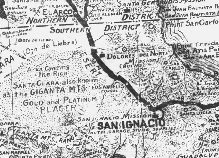
1941 Road Map
For fun, here's a close up of a 1941 road map of this part of Baja (note the words 'unexplored' in places)... Of interest it shows both a mission of
Dolores del Norte and San Pablo, seperately! The heavy black line was the main dirt road, in those days... right up to 1973, in fact!
|
|
|
|


