| Pages:
1
2
3
4
5
6 |
cat127
Junior Nomad

Posts: 50
Registered: 7-23-2006
Location: Hawaii
Member Is Offline
|
|
Hey Bruce no worries! The media here does a hurricane preparedness thing at least once a week... got the genny ready, canned goods & pet food on
hand... flashlights and cell phones charged....... everyday during the season. Oh yah and plenty tequila - it's medicinal.
I worry for y'all's safety 
-Cat
Fate Smiles as Destiny laughs!
|
|
|
capt. mike
Elite Nomad
     
Posts: 8085
Registered: 11-26-2002
Location: Bat Cave
Member Is Offline
Mood: Sling time!
|
|
i had planned flights to Guaymas and Mulege Fri/sat. We are going to cancel till 30th i guess.
from the BBP which got my attention:
Hurricane Lane forecast to land mid Baja - 9/14/2006
The Red Cross called us today to indicate that they are suspending all relief efforts in Baja and evacuating all their personal to the mainland
because of the danger of Hurricane Lane. It is possible that we will be starting all over again.
They indicate that it is forecast to be Cat II when it makes land at Cabo San Lucas and then is forcast to continue up past La Paz and Loreto where at
some point, it will be downgraded to a Tropical Depression.
What they are really saying is that the path is following exactly as John did but with more intensity.
They indicate that Mulege will experience heavy rain starting Saturday afternoon and continue until the depression passes or dies out.
They have requested that I have people on alert to help by mid-week next week including fixed wings and helicopters.
And Karaen and I have been purchasing things from donations. This includes soap, towels, tarps, cooking utensils, tooth brushes, and a lot more. I
will post a complete list. Donations at our office are up to US$1,400.
We have been talking to Marcos at the Serenidad and he indicates that the town was alerted about the storm at about noon today, he also indicated that
the town is very nervous and hopes they can get through another one....
We will do another Alert when ready and hope to give all that help advance notice.
formerly Ordained in Rev. Ewing\'s Church by Mail - busted on tax fraud.......
Now joined L. Ron Hoover\'s church of Appliantology
\"Remember there is a big difference between kneeling down and bending over....\"
www.facebook.com/michael.l.goering |
|
|
Bruce R Leech
Elite Nomad
     
Posts: 6796
Registered: 9-20-2004
Location: Ensenada formerly Mulege
Member Is Offline
Mood: A lot cooler than Mulege
|
|
Good news they continue to move the proposed track of Lane to the east.
the latest showed the center of Lane not even touching Baja. of course there will still be some rain and wind in some areas but it is looking good
Bruce R Leech
Ensenada
 |
|
|
Bob and Susan
Elite Nomad
     
Posts: 8807
Registered: 8-20-2003
Location: Mulege BCS on the BAY
Member Is Offline
Mood: Full Time Residents
|
|
my stuff shows it will be right on top of you sunday...

|
|
|
MrBillM
Platinum Nomad
       
Posts: 21656
Registered: 8-20-2003
Location: Out and About
Member Is Offline
Mood: It's a Zip-a-Dee-Doo-Dah Day
|
|
Forecasts
More than anything else, it shows the abject futility of accepting any of these EARLY forecasts as being meaningful. Tomorrow's may show it going in
an entirely different direction and still end up being wrong.
|
|
|
Bruce R Leech
Elite Nomad
     
Posts: 6796
Registered: 9-20-2004
Location: Ensenada formerly Mulege
Member Is Offline
Mood: A lot cooler than Mulege
|
|
I am going to stick my neck out and make a predication that is contrary to all the models at this time . if you study the satellite image loop there
is a strong upper level west to east wind that is really keeping Lane from getting organized. while Lane try to maintain counter clockwise rotation
and north west movement these westerly winds are tearing the leading edge of Lane of and pushing it to the east. these are very god signs in my
opinion that the storm will weaken and blow in to mainland Mexico.
please don't anyone change you emergency preparedness based on my observations.
Bruce R Leech
Ensenada
 |
|
|
MrBillM
Platinum Nomad
       
Posts: 21656
Registered: 8-20-2003
Location: Out and About
Member Is Offline
Mood: It's a Zip-a-Dee-Doo-Dah Day
|
|
Dueling Forecasts
Well, there you go.
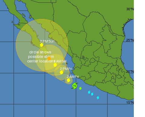
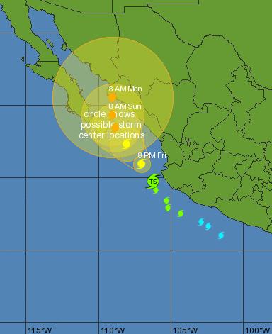
Nothing could make the point better. NOAA's track and Bob and Susan's for the same time period (2am Friday) show a different track. Flip a coin,
pick straws, roll dice. Any of those are as likely to produce an accurate result.
The upper level winds and the High Pressure centered over Mainland Mexico were supposed to make JOHN take the Westward hook which
never developed.
Quien Sabe ?
|
|
|
Bruce R Leech
Elite Nomad
     
Posts: 6796
Registered: 9-20-2004
Location: Ensenada formerly Mulege
Member Is Offline
Mood: A lot cooler than Mulege
|
|
| Quote: | Originally posted by MrBillM
Well, there you go.
Nothing could make the point better. NOAA's track and Bob and Susan's for the same time period (2am Friday) show a different track. Flip a coin,
pick straws, roll dice. Any of those are as likely to produce an accurate result.
The upper level winds and the High Pressure centered over Mainland Mexico were supposed to make JOHN take the Westward hook which
never developed.
Quien Sabe ? |
it is like betting on what a cat is going to do next
Bruce R Leech
Ensenada
 |
|
|
Bruce R Leech
Elite Nomad
     
Posts: 6796
Registered: 9-20-2004
Location: Ensenada formerly Mulege
Member Is Offline
Mood: A lot cooler than Mulege
|
|
if you look closely to the sat. loop that patch of clouds to the west of lane is starting to rotate in a counter clockwise direction and is robing
significant energy from Lane. it could form another tropical depression.
Bruce R Leech
Ensenada
 |
|
|
capt. mike
Elite Nomad
     
Posts: 8085
Registered: 11-26-2002
Location: Bat Cave
Member Is Offline
Mood: Sling time!
|
|
this doesn't look good:
http://www.weather.com/maps/geography/centralamerica/index_l...
about to pummel cabo?
formerly Ordained in Rev. Ewing\'s Church by Mail - busted on tax fraud.......
Now joined L. Ron Hoover\'s church of Appliantology
\"Remember there is a big difference between kneeling down and bending over....\"
www.facebook.com/michael.l.goering |
|
|
Bajaboy
Ultra Nomad
    
Posts: 4375
Registered: 10-9-2003
Location: Bahia Asuncion, BCS, Mexico
Member Is Offline
|
|
| Quote: |
it is like betting on what a cat is going to do next |
I'll bet my cat is going to eat a bit and then nap all day
Wishing the best for our friends down south.
Zac
|
|
|
BajaNews
Super Moderator
      
Posts: 1439
Registered: 12-11-2005
Member Is Offline
|
|
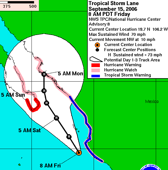
TROPICAL STORM LANE ADVISORY NUMBER 8
NWS TPC/NATIONAL HURRICANE CENTER MIAMI FL EP132006
800 AM PDT FRI SEP 15 2006
...LANE ALMOST A HURRICANE...NEW WARNINGS AND WATCHES ISSUED...
AT 800 AM PDT...1500 UTC...THE GOVERNMENT OF MEXICO HAS ISSUED A
HURRICANE WARNING FOR SOUTHERN BAJA CALIFORNIA SOUTH OF AGUA BLANCA
ON THE PACIFIC COAST AND SOUTH OF BUENA VISTA ON THE GULF OF
CALIFORNIA COAST. A HURRICANE WARNING ALSO REMAINS IN EFFECT FOR
THE ISLAS MARIAS. A HURRICANE WARNING MEANS THAT HURRICANE
CONDITIONS ARE EXPECTED WITHIN THE WARNING AREA WITHIN THE NEXT 24
HOURS. PREPARATIONS TO PROTECT LIFE AND PROPERTY SHOULD BE RUSHED
TO COMPLETION.
AT 800 AM PDT...1500 UTC...THE GOVERNMENT OF MEXICO HAS ISSUED A
HURRICANE WATCH FROM CABO CORRIENTES TO LA CRUZ. A TROPICAL STORM
WARNING AND A HURRICANE WATCH ARE NOW IN EFFECT FROM MANZANILLO TO
LA CRUZ. A HURRICANE WATCH MEANS THAT HURRICANE CONDITIONS ARE
POSSIBLE WITHIN THE WATCH AREA...GENERALLY WITHIN 36 HOURS. A
TROPICAL STORM WARNING MEANS THAT TROPICAL STORM CONDITIONS ARE
EXPECTED WITHIN THE WARNING AREA WITHIN THE NEXT 24 HOURS.
HURRICANE WARNINGS COULD BE REQUIRED FOR PORTIONS OF THIS AREA
LATER TODAY.
AT 800 AM PDT...1500 UTC...THE GOVERNMENT OF MEXICO HAS ISSUED A
HURRICANE WATCH FOR THE EAST COAST OF THE GULF OF CALIFORNIA NORTH
OF LA CRUZ TO HUATABAMPITO....AND FOR THE GULF OF CALIFORNIA COAST
OF BAJA CALIFORNIA NORTH OF BUENA VISTA TO LORETO.
AT 800 AM PDT...1500 UTC...THE GOVERNMENT OF MEXICO HAS DISCONTINUED
ALL WATCHES AND WARNINGS SOUTH OF MANZANILLO.
FOR STORM INFORMATION SPECIFIC TO YOUR AREA...INCLUDING POSSIBLE
INLAND WATCHES AND WARNINGS...PLEASE MONITOR PRODUCTS ISSUED
BY YOUR LOCAL WEATHER OFFICE.
AT 800 AM PDT...1500Z...THE CENTER OF TROPICAL STORM LANE WAS
LOCATED NEAR LATITUDE 19.7 NORTH...LONGITUDE 106.2 WEST OR ABOUT 135
MILES...215 KM...WEST-NORTHWEST OF MANZANILLO MEXICO AND ABOUT 325
MILES...525 KM...SOUTHEAST OF CABO SAN LUCAS MEXICO.
LANE IS MOVING TOWARD THE NORTHWEST NEAR 10 MPH...17 KM/HR...AND
THIS GENERAL MOTION IS EXPECTED TO CONTINUE WITH SOME DECREASE IN
FORWARD SPEED DURING THE NEXT 24 HOURS. ON THIS TRACK...THE CENTER
OF LANE IS FORECAST TO REMAIN OFFSHORE. HOWEVER...ONLY A SLIGHT
DEVIATION TO THE RIGHT COULD BRING THE CENTER VERY NEAR THE COAST
OF MAINLAND MEXICO WITHIN THE WATCH AND WARNING AREAS.
MAXIMUM SUSTAINED WINDS ARE NEAR 70 MPH...110 KM/HR...WITH HIGHER
GUSTS. STRENGTHENING IS FORECAST DURING THE NEXT 24 HOURS...AND
LANE IS EXPECTED TO BECOME A HURRICANE LATER TODAY. AN AIR FORCE
RESERVE HURRICANE HUNTER AIRCRAFT IS SCHEDULED TO INVESTIGATE LANE
THIS AFTERNOON.
TROPICAL STORM FORCE WINDS EXTEND OUTWARD UP TO 105 MILES...165 KM
FROM THE CENTER.
ESTIMATED MINIMUM CENTRAL PRESSURE IS 990 MB...29.23 INCHES.
COASTAL STORM SURGE FLOODING OF 1 TO 3 FEET ABOVE NORMAL TIDE
LEVELS...ACCOMPANIED BY LARGE AND DANGEROUS BATTERING WAVES CAN BE
EXPECTED IN AREAS OF ONSHORE FLOW NEAR THE PATH OF THE CENTER OF
LANE.
TOTAL RAINFALL ACCUMULATIONS OF 2 TO 4 INCHES ARE EXPECTED ALONG THE
WEST CENTRAL COAST OF MEXICO...WITH ISOLATED MAXIMUM AMOUNTS OF 6
INCHES POSSIBLE OVER THE COASTAL MOUNTAINS. TOTAL RAINFALL
ACCUMULATIONS OF 4 TO 8 INCHES...WITH POSSIBLE ISOLATED MAXIMUM
AMOUNTS OF 12 INCHES...ARE POSSIBLE OVER THE SOUTHERN BAJA
CALIFORNIA PENINSULA. THESE RAINFALL AMOUNTS COULD CAUSE
LIFE-THREATENING FLASH FLOODS AND MUDSLIDES.
REPEATING THE 800 AM PDT POSITION...19.7 N...106.2 W. MOVEMENT
TOWARD...NORTHWEST NEAR 10 MPH. MAXIMUM SUSTAINED WINDS...70 MPH.
MINIMUM CENTRAL PRESSURE...990 MB.
|
|
|
JZ
Elite Nomad
     
Posts: 9271
Registered: 10-3-2003
Member Is Offline
|
|
It is heading straight for San Carlos, Sonora!
"THE NEW FORECAST TRACK BRINGS LANE UP THE CENTER OF THE GULF OF CALIFORNIA THROUGH 72 HR...SO THE NEW INTENSITY FORECAST CALLS FOR MORE STRENGTHENING
THROUGH 48 HR AND LESS WEAKENING THEREAFTER THAN THE PREVIOUS PACKAGE."
|
|
|
Bob and Susan
Elite Nomad
     
Posts: 8807
Registered: 8-20-2003
Location: Mulege BCS on the BAY
Member Is Offline
Mood: Full Time Residents
|
|
bruce may be correct for a change ...
the latest...

|
|
|
BajaNews
Super Moderator
      
Posts: 1439
Registered: 12-11-2005
Member Is Offline
|
|
3-day wind and direction prediction as of 8am Friday

|
|
|
Bruce R Leech
Elite Nomad
     
Posts: 6796
Registered: 9-20-2004
Location: Ensenada formerly Mulege
Member Is Offline
Mood: A lot cooler than Mulege
|
|
every 12 hours they are moving the track more to the east and this is only good news for most of us in Baja Sur.
I think It will continue to go that way and when it gets a Little further to the north the upper level wind Sherie is going to weaken Lane
significantly.
Bruce R Leech
Ensenada
 |
|
|
toneart
Ultra Nomad
    
Posts: 4901
Registered: 7-23-2006
Member Is Offline
Mood: Skeptical
|
|
| Quote: | Originally posted by Bruce R Leech
these westerly winds are tearing the leading edge of Lane of and pushing it to the east. these are very god signs in my opinion that the storm will
weaken and blow in to mainland Mexico.
"God signs" indeed! |
|
|
|
capitolkat
Senior Nomad
  
Posts: 510
Registered: 3-9-2006
Member Is Offline
|
|
bajajudy
Judy I was in San Jose on Wednesday and saw the jetty's for the marina and they have really added so much stone it seems like it might work. there is
a new development-maybe two new developments to the east - one a fractional ownership called La Serena or something like that. Are you close to that
locale?? it appears that lots of water came down that arroyo from John and some rains in the hills on Friday a week ago.
Life is too short to drink bad wine
|
|
|
BajaNews
Super Moderator
      
Posts: 1439
Registered: 12-11-2005
Member Is Offline
|
|

|
|
|
BajaNews
Super Moderator
      
Posts: 1439
Registered: 12-11-2005
Member Is Offline
|
|
Tropical Storm Lane nears hurricane strength
http://www.weatherunderground.com/blog/JeffMasters/comment.h...
by Jeff Masters
Tropical Storm Lane continues to intensify just off the Mexican Pacific Ocean coast near Puerto Vallarta. Animations of microwave satellite images
show that Lane is moving parallel to the coast, about 60 miles offshore, remarkably close to the track of Hurricane John earlier this month. Lane is
over warm waters and under light shear, and and has the potential to become a hurricane later today. The only inhibiting factor for intensification
might be the storm's close proximity to land. Lane will be drawing in dry continental air from mainland Mexico that might slow down the
intensification process. Hurricane John was able to intensify into a Category 4 hurricane under virtually the same conditions, but Lane is a much
smaller storm, and might be more seriously impacted by interaction with land. If Lane can avoid passing too close to land areas, she may have enough
time to intensify into a Category 2 hurricane before landfall. The people of Baja, who are still cleaning up the damage and repairing the roads washed
out by Hurricane John, are probably not too happy to see Lane approaching on Cabo San Lucas radar.
|
|
|
| Pages:
1
2
3
4
5
6 |

