Fatboy
Senior Nomad

Posts: 716
Registered: 6-28-2005
Member Is Offline
|
|
Just where is Mission Santa Maria?
We decided at the last minute to head out to Mission Santa Maria de los Angeles, so we headed out through Rancho Santa Ines where we asked were the
start of the road was.
After a couple of turn arounds we were on the road that looks like the correct one. After about 10 miles or so we had a few views of the Sea of
Cortez. After about 12 miles we started getting into area with boulders similar to the Catavina Area.
Then the road started heading down and over 3 or 4 rough sections that had me concerned about coming out since we were fully loaded with camping gear
and two kayaks on the unlocked Wrangler.
At the bottom was a bunch of palms that we drove through missing some of the deeper holes. It was like driving through a jungle after the desert.
We then traveled up the other side of the canyon to where it topped out for a minute and started heading down over a ledge. We had right about 14
miles on the odometer but we made a few wrong turns in the beginning and did not not the exact mileage.
Any idea how close we were to the mission?
Also, can you continue on past the mission and get out to Hwy 1 near San Martin/San Igancito as it shows in the Baja Almanac?
|
|
|
TMW
Select Nomad
Posts: 10659
Registered: 9-1-2003
Location: Bakersfield, CA
Member Is Offline
|
|
The road ends near the mission. You must have been right there. The mission would be on your right going in, up on a knoll like. Palm trees in the
area. The first bunch of palm trees is the right direction. The topo map shows a trail out to hwy one but it's not passable in a vehicle. David K has
lots of pixs on his web site.
|
|
|
Jack Swords
Super Nomad
Posts: 1094
Registered: 8-30-2002
Location: Nipomo, CA/La Paz, BCS
Member Is Offline
|
|
Yep, you were there! Too bad you didn't get to walk around the mission. It is, by far, my favorite mission (and, I believe, David Ks also). The
remoteness and great hiking is breathtaking. Your description of the trip is right on. Now you need to go back, walk around, take some photographs.
|
|
|
wilderone
Ultra Nomad
Posts: 3782
Registered: 2-9-2004
Member Is Offline
|
|
Yes - you were very close. It's 13 mi. You should have gotten out and walked. I backpacked it from Rcho Sta Inez a few years ago. The best part of
the area is just past the mission itself, down the trail along the arroyo - up the pass and down into Sta. Maria canyon - more pools and spectacular
views, as well as petroglyphs.
|
|
|
David K
Honored Nomad
Posts: 64523
Registered: 8-30-2002
Location: San Diego County
Member Is Offline
Mood: Have Baja Fever
|
|
Maybe the longest 14.5 miles in Baja (2 hrs. 30 min.), and you were just feet away from the mission!
It is next to the second group of palms you saw, coming down the ridge from the first palm oasis you drove through...

The road can be driven 1.6 miles past the mission: 1.3 miles is a fork, ahead dead ends in a palm grove, turn left out of the arroyo... you can go
about 0.3 mi. more before the rocks and ruts are too big then get out and walk to the end of this bulldozed grade. At the end is a view down into the
Santa Maria canyon and a few petroglyphs made by ancient Indians.

A trail continues down into the canyon which was the El Camino Real used by the Jesuits. Junipero Serra had a better trail built that stays above the
north side of the canyon... It leaves the bulldozed road near where you park your Jeep and begin the walk.

In this aerial view, the bulldozed road is seen climbing to the ridge where the effort to build a road to Gonzaga Bay was abandoned, and the Indian
trail continues on down into the canyon... about 2 miles east of the mission. The El Camino Real used by Franciscans and those who followed, until
automobiles replaced mules climbs to the left from the bulldozed grade to the top of the mountain then parallels the canyon to the desert floor... See
http://vivabaja.com/1103/page2.html to find that end of the Camino Real, west of Gonzaga Bay.
See Baja Mur's web page for photos of the first time we visited the mission in 1999, includes a 360 degree panorama at the mission, just like if you
were there!: http://bajamur.homestead.com/index.html
[Edited on 10-6-2006 by David K]
|
|
|
David K
Honored Nomad
Posts: 64523
Registered: 8-30-2002
Location: San Diego County
Member Is Offline
Mood: Have Baja Fever
|
|
To get to the mission from Gonzaga Bay (leave early for the 4-5 hour hike):
GPS Directions (map datum NAD27 Mexico)
Take Hwy. 5 south 7.4 miles from Rancho Grande, turn west: 29°41.094'/ 114°24.566'
3.2 miles west of Hwy. 5, go straight where most traffic curves left for Las Palmitas: 29°41.278'/ 114°27.639'
0.8 miles from above, park at huge boulder: 29°41.68'/ 114°28.20'
Hike to north bank of Arroyo Santa Maria to: 29°41.733'/ 114°28.175' elev. 609'
Go northwest and climb out of valley, note ocotillos.
Along left side of side valley: 29°42.374'/ 114°28.566' elev. 741'
On first padre built switchback up: 29°42.669'/ 114°28.937' elev. 906'
On a ridge, trail continues northwest: 29°42.671'/ 114°29.425' elev. 1308'
On the Camino Real: 29°42.748'/ 114°29.482' elev. 1391'
Crossing ridges and little mesas: 29°43.008'/ 114°29.967' elev. 1477'
Drop along side of ridge, trail narrow: 29°43.074'/ 114°30.128' elev.1610'
End of today's hike just beyond this last clear sign of the old trail: 29°43.141'/ 114°30.189' elev. 1702' (note, Don Jorge continued on to the
mission a couple weeks after I ran out of daylight, at this point)
From Don Jorge: JCN. El Camino Real & bulldozed road: 29°43.12'/ 114°31.71' elev.1421' (End of bulldozed road, east of the mission: 29°43.033'/
114°31.556' elev. 1,615' )
Mision Santa Maria: 29°43.888'/ 114°32.791' elev.1651'
|
|
|
David K
Honored Nomad
Posts: 64523
Registered: 8-30-2002
Location: San Diego County
Member Is Offline
Mood: Have Baja Fever
|
|
By the way, Ken Cooke is leading a caravan to the mission in November...
|
|
|
Fatboy
Senior Nomad
Posts: 716
Registered: 6-28-2005
Member Is Offline
|
|
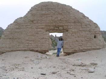
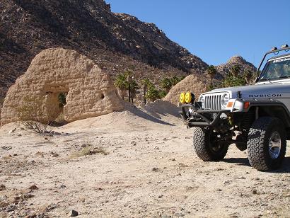
It appears we went down the 'Widow Maker', through the 'Swamp' and up the hill and all we had to do was go down the last hill were we turned around
and we would have been there.
If this lets me post this illegally 'borrowed' picture...this is where we turned around at...

|
|
|
Ken Cooke
Elite Nomad
Posts: 8921
Registered: 2-9-2004
Location: Riverside, CA
Member Is Offline
Mood: Black Trans Lives Matter
|
|
| Quote: | Originally posted by David K
By the way, Ken Cooke is leading a caravan to the mission in November... |
Thanks, David!
In November we're taking a group there. If you don't want to worry about being left behind or getting stuck at the bottom of any steep grades, our
group will be right for you.
If you made it through to the other side of the swamp, you were only a mile or two away from the actual Mission ruins.
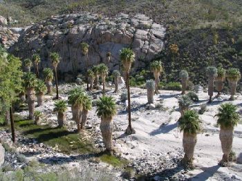
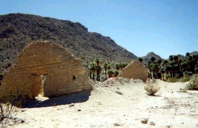
Here is the tiny rock garden when you exit the swamp:
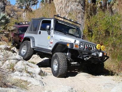
As you meander down the rock and dirt trail towards the Mission ruins, the road begins to look like this:
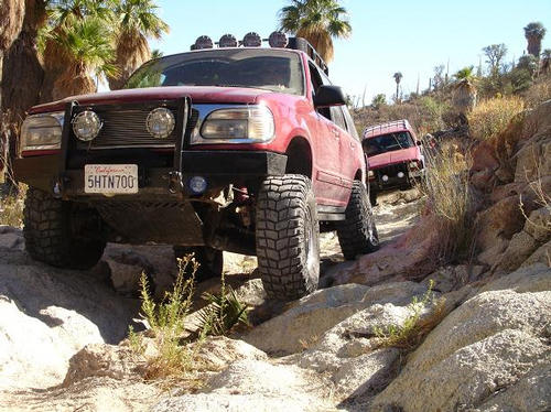
There are a number of smooth granite boulders you actually drive over in order to continue down some more steep, narrow, and crooked sections of
trail.
After some real tight trail driving, the trail suddenly straightens out, and suddenly, you are at the doorstep of the old Mission:
|
|
|
David K
Honored Nomad
Posts: 64523
Registered: 8-30-2002
Location: San Diego County
Member Is Offline
Mood: Have Baja Fever
|
|
The mission is on a small mesa, next to the second grove of palms... It is possible to drive right past the mission without seeing it as the road
continues east where a right turn goes up a very steep short grade to the small mesa the mission is built on.
That road dead ends 1.6 miles east of the mission, so when you drive back west you will see the mission as there is a road from the mission that goes
east to join that bypass road east.
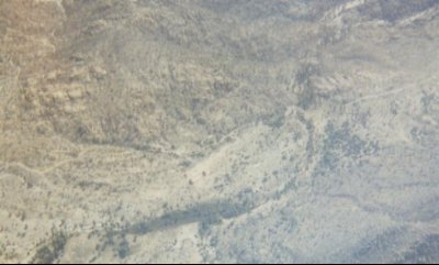
Here's the mission from the air... look close and you can see the end walls in that light colored area... BajaMur and I flew over the area from
Gonzaga Bay in 1999 just after we rode there a couple days earlier... the bypass road going from left to right is seen... The mission is between the
bypass road and the green patch (palms) in the center of the photo, just below the middle...
[Edited on 10-15-2006 by David K]
|
|
|


