| Pages:
1
2 |
David K
Honored Nomad

Posts: 64490
Registered: 8-30-2002
Location: San Diego County
Member Is Offline
Mood: Have Baja Fever
|
|
The 'Widowmaker' Story (getting to Mision Santa Maria)
The extra extreme grade one descends to get to Mision Santa Maria, earned this name on May 1, 1999.
It was during my first trip to the remote and last mission established by the Jesuits who in 1767 moved their final California mission from the bad
water site at Calamajue to the sweet water found at the place the natives called Cadujakaamung.
Baja Mur was on a motorcycle and I was on a quad...
Here we are ready to begin, at Rancho Santa Ynez...

The total distance to the mission from Santa Ynez is only 14.5 miles, but it is one tough burro of a road through beautiful country!

10 miles from Santa Ynez the high point or peninsular divide is reached and we could see the gulf and Punta Final...

From that highpoint, it is mostly downhill to the oasis canyon containing the mission... While it is very slow and rocky, this heart-stopping drop off
is the grade that would be known as 'The Widowmaker'....

Going down was hairy... In fact MOST people park at the top and walk the final 1.2 miles to the mission.
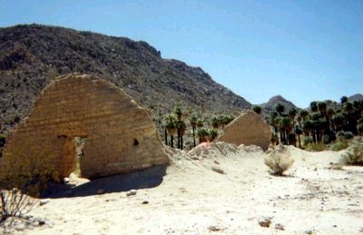
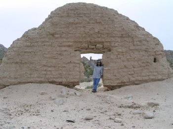
Mission in 1999 from my camera...
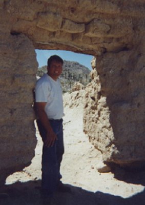
Mur took a photo of me in the doorway... I was so jazzed!
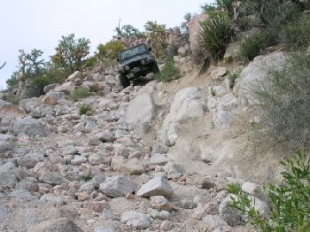
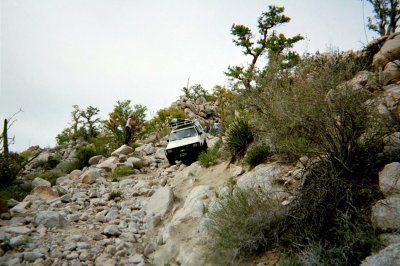
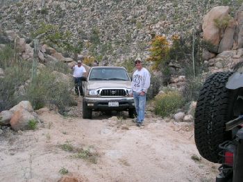
In April, 2003 I returned in my Tacoma along with 'Fishuntr' (Toyota) and 'chicagoross' (Jeep)... I photographed them coming down, after I reached the
bottom...
The top is 13.3 mi. from Santa Ynez,
at 29°44.74'/ 114°33.15' (NAD27) elev. 1,748'
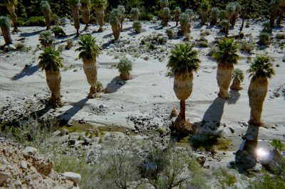
Just beyond the bottom of the Widowmaker, the road enters the stream...

Driving in the reed filled stream was interesting... Good thing there is a bottom to the bog, no tow truck will ever get here! One more rocky hill is
crossed before entering the mission valley... 2 1/2 hours from Santa Ynez, and you arrive! GPS (NAD27) 29°43.89'/ 114°32.79' elev. 1,651'
Jack Swords took this photo looking east...

Anyway, the trip is well worth it if you are in no hurry and have the right type of vehicle!
Now, getting down the Widowmaker was tough (riding a quad)... But, getting back up was dangerous!
In 1999, I went up first as Mur was an experienced motorcycle rider and he was behind... waiting for me to reach the top. I didn't make it... About
halfway up, as I was hanging on for dear life, the quad bounced up and threw me to the rocks... I was shaken, but not stirred... Murray walked up and
the two of us struggled with the quad to get it to the top of the grade. My bleeding stopped and nothing was broken.
I waited for Mur... I heard the motor as he zipped upwards then his motor died!!?? I ran back down the grade (it curves so you cannot see it all from
the top) and discovered Mur was also thrown from his ride and had a gash that produced more blood than did mine!
We became 'Baja Blood Brothers' and I named that damn grade 'The Widowmaker' right then and there!!!
Four years later, in my 4WD Tacoma TRD (with locking rear differential) I climded the Widowmaker again...
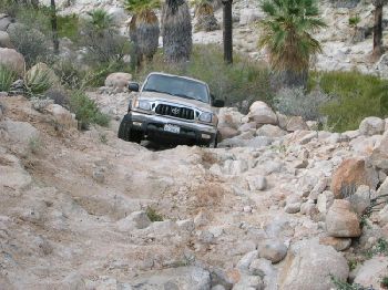
I made it to the top with tire placement help from spotter 'chicagoross'! No bleeding this time... but it was still a hairy experience.
The mission was soon abandoned after the Franciscans took over the missions from the Jesuits... It was too remote even for them! But the water still
flows year round...
If the Indians hadn't died out, this place may still have been inhabited by them...

Viva Bad Roads!, Viva Widowmaker!, Viva Baja!

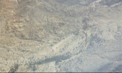
An aerial photo of the Widowmaker (note where road turns down toward palm canyon)...
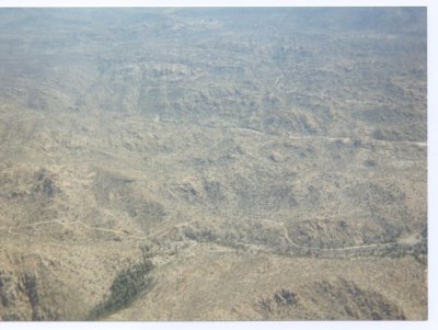
Thanks to Doug Bowles of Alfonsina's who flew us over the mission area a couple days after our ride there...
Mission below... (note end walls on the clearing, below center)
[Edited on 12-13-2006 by David K]
|
|
|
Bajagypsy
Super Nomad
Posts: 1416
Registered: 8-31-2006
Location: BahÃa Asuncion BCS
Member Is Offline
Mood: Living the dream
|
|
That looks like a remarkable place, I think we may have to visit it on one of our trips.
|
|
|
David K
Honored Nomad
Posts: 64490
Registered: 8-30-2002
Location: San Diego County
Member Is Offline
Mood: Have Baja Fever
|
|
If you get to reading Graham Mackintosh... in his second book (Journey with a Baja Burro) he talks fondly of this place... it is one of his favorite
in Baja... Mine Too!!!
When you are there, you feel a special energy... spiritual... the Baja feeling...
I tried hiking to the mission from Gonzaga Bay with my son in 1993 on the Camino Real, but we ran short of daylight: http://vivabaja.com/1103/page2.html


From Gonzaga to Santa Maria:
GPS Directions (map datum NAD27 Mexico)
Take Hwy. 5 south 7.4 miles from Rancho Grande, turn west: 29°41.094'/ 114°24.566'
3.2 miles west of Hwy. 5, go straight where most traffic curves left for Las Palmitas: 29°41.278'/ 114°27.639'
0.8 miles from above, park at huge boulder: 29°41.68'/ 114°28.20'
Hike to north bank of Arroyo Santa Maria to: 29°41.733'/ 114°28.175' elev. 609' (Waypoint: ECR-1)
Go northwest and climb out of valley, note ocotillos.
Along left side of side valley: 29°42.374'/ 114°28.566' elev. 741' (ECR-2)
On first padre built switchback up: 29°42.669'/ 114°28.937' elev. 906' (ECR-3)
On a ridge, trail continues northwest: 29°42.671'/ 114°29.425' elev. 1308' (ECR-4)
On the Camino Real: 29°42.748'/ 114°29.482' elev. 1391' (ECR-5)
Crossing ridges and little mesas: 29°43.008'/ 114°29.967' elev. 1477' (ECR-6)
Drop along side of ridge, trail narrow: 29°43.074'/ 114°30.128' elev.1610' (ECR-7)
End of today's hike just beyond this last clear sign of the old trail: 29°43.141'/ 114°30.189' elev. 1702' (ECR-8)
JCN. El Camino Real & bulldozed road (from Mision Santa Maria, ~1.2 mile west): 29°43.12'/ 114°31.71' elev.1421' (End of bulldozed road, on the
ridge above the canyon: 29°43.033'/ 114°31.556' elev. 1,615' ). The padre's trail comes down the mountain and meets the bulldozed road between the
arroyo and where the road construction ends on the ridge above the canyon.
Mision Santa Maria: 29°43.888'/ 114°32.791' elev.1651'
[Edited on 12-13-2006 by David K]
|
|
|
dean miller
Nomad
Posts: 456
Registered: 1-28-2004
Member Is Offline
|
|
Very interesting --and exciting! with shades of days of yesteryear! Keep them comming!
Interesting that you used the term "Widowmaker." This term became a popular term in the late 1960s after the publication of James Jones last book
"Go to the widowmaker" in 1967. it was one of the first, if not the first Scuba diving story by a popular author. The widowmaker was a cave--This
book brought the term into the American lexicon, and for a short while was used extensively by only divers.. Now it applies to anything that is
dangerous, above or below the H2O.
FYI
James Jones was considered one of the great American writers of his time, but since his death has been all but forgotten. His other books, which were
made in to major movies are: From Here to enternity, Some came running, The thin red line. Widowmaker and The Pistol have not been made into movies.
I have been working on Go to the widowmaker for many years and have only read 190 pages out of 640 pages-Oh yes! spell binding book!
I apologize for the borring discourse...
sdm
|
|
|
kellychapman
Nomad
Posts: 246
Registered: 9-19-2006
Location: Loreto CBS
Member Is Offline
Mood: heavenly
|
|
magnificent pictures....that is what is so nice about this board.....Muchas Gracias.....
|
|
|
David K
Honored Nomad
Posts: 64490
Registered: 8-30-2002
Location: San Diego County
Member Is Offline
Mood: Have Baja Fever
|
|
| Quote: | Originally posted by dean miller
Very interesting --and exciting! with shades of days of yesteryear! Keep them comming!
Interesting that you used the term "Widowmaker." This term became a popular term in the late 1960s after the publication of James Jones last book
"Go to the widowmaker" in 1967. it was one of the first, if not the first Scuba diving story by a popular author. The widowmaker was a cave--This
book brought the term into the American lexicon, and for a short while was used extensively by only divers.. Now it applies to anything that is
dangerous, above or below the H2O.
FYI
James Jones was considered one of the great American writers of his time, but since his death has been all but forgotten. His other books, which were
made in to major movies are: From Here to enternity, Some came running, The thin red line. Widowmaker and The Pistol have not been made into movies.
I have been working on Go to the widowmaker for many years and have only read 190 pages out of 640 pages-Oh yes! spell binding book!
I apologize for the borring discourse...
sdm |
Cool story... I am not sure how I came up with the term, other than it was such a dangerous place that it could make someone's wife a widow! I turned
10 in 1967, but I don't recall reading that book... Thanks for sharing!!!
|
|
|
dean miller
Nomad
Posts: 456
Registered: 1-28-2004
Member Is Offline
|
|
David K,
No one has ever read the book it is too borrrrring--
It has travel with me to Baja on numerous occasions--I can always find something to do other that read Come to the widow maker...
I guess the mute point is the book coined the phrase and it is now part of the American and possibly the world's lexicon for danger or an activity
that is dangerous.
dm
|
|
|
David K
Honored Nomad
Posts: 64490
Registered: 8-30-2002
Location: San Diego County
Member Is Offline
Mood: Have Baja Fever
|
|
Great to know Dean!
I usually tuck a book to read when I go south... never get around to reading it, however.... Baja captures your entire inner soul!
|
|
|
Barry A.
Select Nomad
Posts: 10007
Registered: 11-30-2003
Location: Redding, Northern CA
Member Is Offline
Mood: optimistic
|
|
David/Dean------that is so funny--------I too ALWAYS carry a book or two to Baja and I have NEVER even cracked the cover of one.
I wonder how many of us do that. 
|
|
|
Skipjack Joe
Elite Nomad
Posts: 8084
Registered: 7-12-2004
Location: Bahia Asuncion
Member Is Offline
|
|
Love to read in baja
I read 'Gone with the Wind' and 'How green was my valley' on the shore of Laguna Manuela on one of my favorite trips. Books and siestas go hand in
hand.
That first picture of the road to Santa Maria, David, sure is beckoning. The siren call of the widowmaker, I guess. I hear it's call, even at my ripe
old age. 
|
|
|
David K
Honored Nomad
Posts: 64490
Registered: 8-30-2002
Location: San Diego County
Member Is Offline
Mood: Have Baja Fever
|
|
More photos from Mur's and my trip in '99: http://bajamur.homestead.com/index.html
Photos from my return trip in 2003: http://vivabaja.com/403 (see the rattlesnake who came into our camp at the mission)
|
|
|
Barry A.
Select Nomad
Posts: 10007
Registered: 11-30-2003
Location: Redding, Northern CA
Member Is Offline
Mood: optimistic
|
|
David-------
----better a rattle snake than that loon pictured on the "radiation" thread!!!!
|
|
|
Neal Johns
Super Nomad
Posts: 1687
Registered: 10-31-2002
Location: Lytle Creek, CA
Member Is Offline
Mood: In love!
|
|
Hope to see you in Lytle Creek, Barry..........

My motto:
Never let a Dragon pass by without pulling its tail!
|
|
|
Barry A.
Select Nomad
Posts: 10007
Registered: 11-30-2003
Location: Redding, Northern CA
Member Is Offline
Mood: optimistic
|
|

I have no come back to that one, Neal-----guess I walked right into it.
(that guy even sorta looks like me)
|
|
|
bajapablo
Nomad
Posts: 226
Registered: 1-27-2004
Member Is Offline
|
|
cool post
David K. That mission site looks awesome. I also enjoyed your post on the petrified wood trip. As far as reading a book in baja, nothing I enjoy
more than a good book and laying in a hammock next to Gonzaga Bay.
\"changes it lattitudes, changes in attitudes\"
J.Buffet
|
|
|
David K
Honored Nomad
Posts: 64490
Registered: 8-30-2002
Location: San Diego County
Member Is Offline
Mood: Have Baja Fever
|
|
Well, when you are at Gonzaga Bay, just look to the southwest... that mission is less than 10 miles (as the crow flies) away!
In May of 1999, after the mission ride we went to Alfonsina's, did some fishing one day off the island, then another day we hiked up Santa Maria
canyon from the point we could no longer drive... to see if we could get to the mission! We did not know about the El Camino Real location in relation
to the canyon (it stays on the north ridge)...
Anyway, just a short hike up the canyon we found this:

So naturally, I had to do this:

The next day we had Douglas fly us over the canyon and mission for a recon... We knew we were close!
Here's the view of the canyon mouth out to Gonzaga:
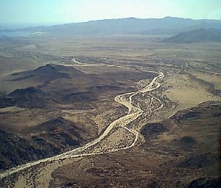
Here's the spot where we could swim, and did!:
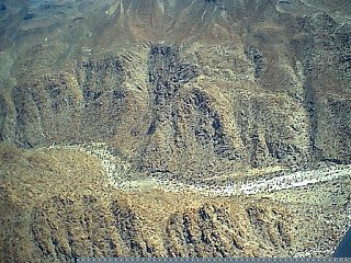
Here's near the top of the canyon where you can see the bulldozed road building attempt from Santa Ynez and the mission to Gonzaga ended on the ridge
above the canyon, less than 2 miles from the mission. You can also see the Indian trail continue on down into the canyon. This was the first Camino
Real route... It was replaced by a better trail that stays out of the canyon on the north side....

Viva Baja!
[Edited on 12-14-2006 by David K]
|
|
|
Barry A.
Select Nomad
Posts: 10007
Registered: 11-30-2003
Location: Redding, Northern CA
Member Is Offline
Mood: optimistic
|
|
David------
If you drove as far west as you could up the appropriate wash from Gonzaga in a competant 4x4, how long of a hike would you estimate it is to the
Mission??
and what is the altitude of the Mission??
|
|
|
Neal Johns
Super Nomad
Posts: 1687
Registered: 10-31-2002
Location: Lytle Creek, CA
Member Is Offline
Mood: In love!
|
|
Barry, DK is probably working. I hiked up the wash from where a two track off the road to La Palmita enters it and a quad could probably make it that
far. A 4x4 could only make it a half mile or so depending upon recent floods. Easy hike. Where I stopped, there was a side canyon right with a very
large cairn (land marker?). The side canyon probably intersects the ECR trail somewhere.
How far up canyon to the Mission? You better be a rock climber to get up the waterfalls in the canyon. I'll take a look at Google Earth and see if it
has high resolution in that area. (distance and elevation)
Distance from where two track enters SM wash to Mission (adding some to straight line) is 5 miles up canyon from where I hiked (about 5.3 straight
line from where two track enters wash to Mission).
Elevation at where two track enters wash about 620 feet.
Elevation at Mission about 1600 feet.
Rd west to SM wash from Gonzaga/Coco's road at 29 Deg 41.078 Min
114 Deg 24.613 Min
2 track enters SM wash at about 29 deg 41.6 min 114 deg 28.167 Min
Google Earth low res pic:
[Edited on 12-14-2006 by Neal Johns]

My motto:
Never let a Dragon pass by without pulling its tail!
|
|
|
Barry A.
Select Nomad
Posts: 10007
Registered: 11-30-2003
Location: Redding, Northern CA
Member Is Offline
Mood: optimistic
|
|
Neal----thanks for the input-------I am still pretty confused.
1. Is the "road to La Palmita" of which you speak shown in the Baja Atlas as the dotted line up Canyon San Luis Alfredo (from El Faro on the coast),
and then to the mouth of Las Palmitas canyon ?? Is that the road you are talking about? And is this the best approach to the Mission? (not sure of
what you mean by "La Palmita")
2. Are you saying that the best way from Gonzaga to the Mission is NOT up Santa Maria canyon? because it is too rough (dry waterfalls, etc.)?
3. Can you not intersect the El Camino Real someplace between the Santa Maria Mission and Calamajue Mission site (as close to Santa Maria as
possible) and therefore have a fairly easy (no dry waterfalls) "hike" into M. Santa Maria on that historical trail?
|
|
|
Barry A.
Select Nomad
Posts: 10007
Registered: 11-30-2003
Location: Redding, Northern CA
Member Is Offline
Mood: optimistic
|
|
Neal-----
----I too went into GOOGLE EARTH, but I could not get very good resolution in the area of the Mission Santa Maria, but it was close enough to see that
it is a really rugged area. I could barely make out Hyway 1, and the bigger washes, but that was it. I could not make out the approach road from
Santa Inez to the Mission---just to blurry.
|
|
|
| Pages:
1
2 |


