David K
Honored Nomad

Posts: 64493
Registered: 8-30-2002
Location: San Diego County
Member Is Offline
Mood: Have Baja Fever
|
|
Baja Missions from space!
This is a list of links to satellite photos of mission sites... only those covered by high resolution photography are listed.
After clicking on a link, enlarge the new window then click on 'Link to this page' to make the photo large as possible.
Guadalupe del Norte
San Miguel de la Frontera
Santo Tomas (final site)
San Vicente
Santo Domingo (half in low resolution)
San Pedro Martir
Rosario (de Arriba)
Rosario (de Abajo)
San Fernando Velicata
Calamajue (first site of Santa Maria)
San Francisco Borja
San Ignacio
Loreto
San Francisco Javier
Comondu Viejo (?)
San Jose de Comondu
San Luis Gonzaga
No ruins at La Purisima, Ligui, La Paz, Santiago, & San Jose del Cabo
Only a wall at Todos Santos
Dolores (del Sur), Santa Maria, Santo Tomas 1st site, Santa Catalina & Descanso are not in high resolution areas...
[Edited on 2-13-2007 by David K]
|
|
|
Jack Swords
Super Nomad
Posts: 1094
Registered: 8-30-2002
Location: Nipomo, CA/La Paz, BCS
Member Is Offline
|
|
Fantastic David! Nice to see the spots walked upon from on high. Hope to see more.
5 AM, La Paz, headed out to hike up to El Zalate (Angel de la Guarda). Visita site?? Will know this PM. Still green, highs in the 80's.
|
|
|
Mexitron
Ultra Nomad
Posts: 3397
Registered: 9-21-2003
Location: Fort Worth, Texas
Member Is Offline
Mood: Happy!
|
|
Nice, wow! Nice seeing that Mission SPM country again--I can see the trees we camped under three years ago! Can't find the zig zag trail down the
Sierra San Miguel though--thought that would stand out better.
|
|
|
FARASHA
Senior Nomad
Posts: 848
Registered: 6-3-2006
Member Is Offline
|
|
HELP - I AM Addicted, to those satellite photos - seeking a 12 steps programm!!
Can hang in there for HOURS !!
Thanks David >f<
[Edited on 10-2-2007 by FARASHA]
|
|
|
David K
Honored Nomad
Posts: 64493
Registered: 8-30-2002
Location: San Diego County
Member Is Offline
Mood: Have Baja Fever
|
|
| Quote: | Originally posted by Mexitron
Nice, wow! Nice seeing that Mission SPM country again--I can see the trees we camped under three years ago! Can't find the zig zag trail down the
Sierra San Miguel though--thought that would stand out better. |
I posted it as 'Trail' in the thread on San Isidoro... Here it is again, the switchback just above Arroyo El Horno... and use your mouse to follow it
up to the mission...
Trail climbing
|
|
|
Mexitron
Ultra Nomad
Posts: 3397
Registered: 9-21-2003
Location: Fort Worth, Texas
Member Is Offline
Mood: Happy!
|
|
Nice job DK! That trail was pretty steep, especially after hoofing it up the riverbeds and three of us coming down with colds from the previous
afternoons thunderstorm dunking that we weren't very well prepared for...I really want to explore the area south of there more one of these years--say
do a hike between SPM and Matomi...If you've ever been to the south end of the SPM Park and seen the view out towards Matomi you know what I'm talking
about.
|
|
|
David K
Honored Nomad
Posts: 64493
Registered: 8-30-2002
Location: San Diego County
Member Is Offline
Mood: Have Baja Fever
|
|
Sounds fantastic... Do you have any photos???
|
|
|
Taco de Baja
Super Nomad
Posts: 1913
Registered: 4-14-2004
Location: Behind the Orange Curtain, CA
Member Is Offline
Mood: Dreamin' of Baja
|
|
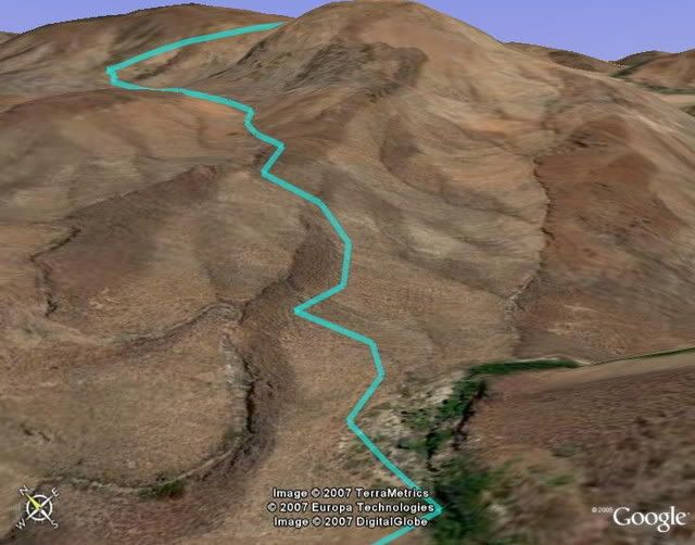
Up Up and Away
An oblique view from Google Earth, showing the at least a 1,000 foot climb from the river to the top. Brings back painful hip memories....
Line is from the GPS track; which even picked up the off trail trip to the creek to get water for the hike to the top. However please note, that this
does not exactly follow the trail, as the GPS was not "continuously" taking points (probably a point every 2 minutes to save memory), but each point
is on the trail, or within 5 meters.
|
|
|
Mexitron
Ultra Nomad
Posts: 3397
Registered: 9-21-2003
Location: Fort Worth, Texas
Member Is Offline
Mood: Happy!
|
|
Taco--I thought the elevation gain was more like 2,000 feet....that last part at the top was the burner but was also where the old trail was still
well defined.
|
|
|
David K
Honored Nomad
Posts: 64493
Registered: 8-30-2002
Location: San Diego County
Member Is Offline
Mood: Have Baja Fever
|
|
| Quote: | Originally posted by Jack Swords
Fantastic David! Nice to see the spots walked upon from on high. Hope to see more.
5 AM, La Paz, headed out to hike up to El Zalate (Angel de la Guarda). Visita site?? Will know this PM. Still green, highs in the 80's.
|
Jack, I tried to spot Comondu Viejo (1st site for San Jose de Comondu)... Please check the link and if those ruins aren't right, could you scroll
around and spot it? The road between San Juan and the driveway for La Presa is where G&G places Comondu Viejo. As the road crosses the arroyo
between those two points it may be easy to find if you remember where it is in relation to the arroyo crossings.
G&G places the ruins 1.1 miles south of San Juan and 0.5 mile north of the La Presa driveway...
San Juan
Ruins of Comondu Viejo???
La Presa driveway
Thanks Jack!
If I have the energy, I could input the GPS for Viejo...! LOL
|
|
|
David K
Honored Nomad
Posts: 64493
Registered: 8-30-2002
Location: San Diego County
Member Is Offline
Mood: Have Baja Fever
|
|
Jack Swords... are you there?
|
|
|
Jack Swords
Super Nomad
Posts: 1094
Registered: 8-30-2002
Location: Nipomo, CA/La Paz, BCS
Member Is Offline
|
|
Comondu Viejo
Hola David...checking in.
We crossed the arroyo, checked in with a local in the area, drove down the road where directed, walked into a low wall, followed the wall to the
ruins. Two structures, adobe one and the stone one. Adobe was just foundation, stone was still intact. I walked east and climbed the ridge for more
photos (you can see it on Google). Then after we drove down the road a bit towards the presa, on our left was the cleared field and the rock wall
constructed from the rocks removed from the field (also visible on Google). The house visible on Google was where we got info, second house was
unoccupied. This was just after a major hurricane and all was flooded, dead stock, roads just deep cobble. Anyway, look at 111º 43'06.21W X
26º16'22.30N. My Google Earth here shows it pretty well. Need to revise coordinates.
[Edited on 14-7-2007 by Jack Swords]
|
|
|
David K
Honored Nomad
Posts: 64493
Registered: 8-30-2002
Location: San Diego County
Member Is Offline
Mood: Have Baja Fever
|
|
| Quote: | Originally posted by Jack Swords
Hola David...checking in.
We crossed the arroyo, checked in with a local in the area, drove down the road where directed, walked into a low wall, followed the wall to the
ruins. Two structures, adobe one and the stone one. Adobe was just foundation, stone was still intact. I walked east and climbed the ridge for more
photos (you can see it on Google). Then after we drove down the road a bit towards the presa, on our left was the cleared field and the rock wall
constructed from the rocks removed from the field (also visible on Google). The house visible on Google was where we got info, second house was
unoccupied. This was just after a major hurricane and all was flooded, dead stock, roads just deep cobble. Anyway, look at 111º 43'06.21W X
26º16'22.30N. My Google Earth here shows it pretty well. Need to revise coordinates.
[Edited on 14-7-2007 by Jack Swords] |
Jack, I was not sure what map datum your GPS is at, but in Dave Werschkul's book he has the waypoint for Comondu Viejo at N26º16'27.3" W111º43'08.4"
(WGS84) and mentions the ruins were about 50 yards (150') north of the rancho.
I entered his waypoint onto Wikimapia.org and marked the spot: http://wikimapia.org/#lat=26.274250&lon=-111.71900&z...
Here is the direct link:Comondu Viejo from space
Here is your photo of the Comondu Viejo ruins:

The GPS originally given with your photo (26º16.45' 111º43.15') is right next to Dave's... so this location would seem to be correct. Also, you can
see an El Camino Real trail heading to the southwest from the site.
[Edited on 11-9-2008 by David K]
|
|
|
David K
Honored Nomad
Posts: 64493
Registered: 8-30-2002
Location: San Diego County
Member Is Offline
Mood: Have Baja Fever
|
|
Since this post, more of Baja is in high or higher than before resolution!
Dolores del Sur/ Apate
Dolores del Sur 2nd site/ Chilla (La Pasion)
Santa Maria de los Angeles
Mision Santo Tomas 1st site
Mision Santa Catalina site
El Descanso mission site
[Edited on 11-9-2008 by David K]
|
|
|


