| Pages:
1
2 |
TMW
Select Nomad

Posts: 10659
Registered: 9-1-2003
Location: Bakersfield, CA
Member Is Offline
|
|
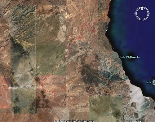
Off Road to Bahia Guadalupe
Using Google Earth I followed the dirt road from the LA Bay hwy across Luguna Agua Amarga, almanac pg 21, up to Mesa de Yubay and out the wash to
Bahia Guadalupe. I attemped this a few years ago but never made it to Mesa de Yubay.

|
|
|
TMW
Select Nomad
Posts: 10659
Registered: 9-1-2003
Location: Bakersfield, CA
Member Is Offline
|
|
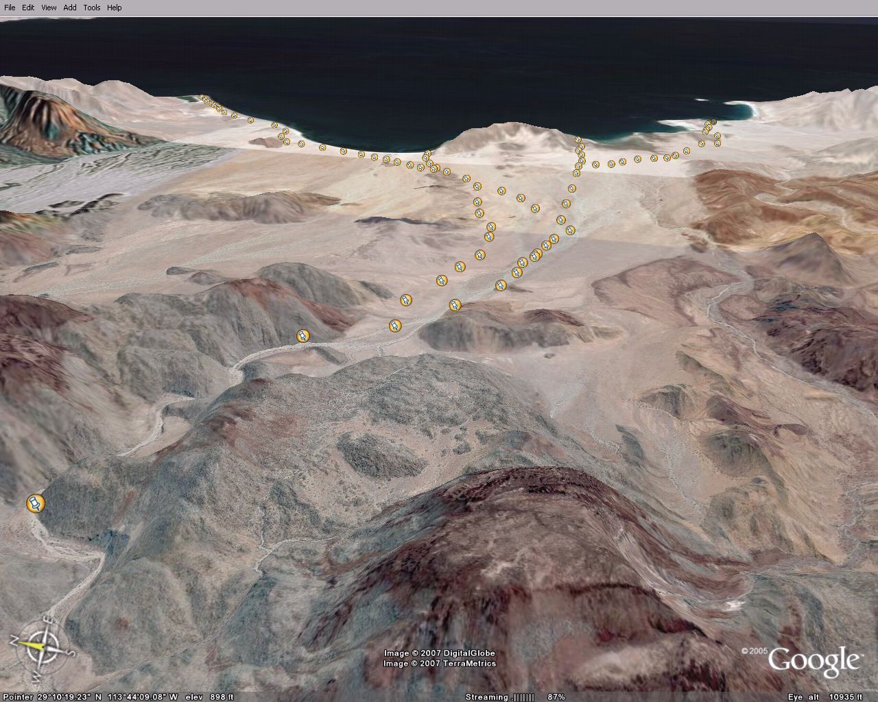
This is before the Mesa de Yubay wash after crossing the Laguna.

|
|
|
TMW
Select Nomad
Posts: 10659
Registered: 9-1-2003
Location: Bakersfield, CA
Member Is Offline
|
|
In the top of the previous pix there is a dark rock. This is the rock where you join Mesh de Yubay. From here you follow the wash to the Sea of
Cortez.

|
|
|
TMW
Select Nomad
Posts: 10659
Registered: 9-1-2003
Location: Bakersfield, CA
Member Is Offline
|
|
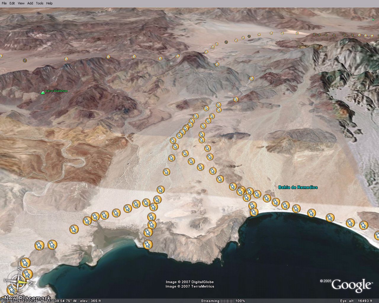
This pix is at Bahia Guadalupe. A few miles before here the road exits the wash on the north side.

|
|
|
TMW
Select Nomad
Posts: 10659
Registered: 9-1-2003
Location: Bakersfield, CA
Member Is Offline
|
|
A closer view of the fish camp.

|
|
|
TMW
Select Nomad
Posts: 10659
Registered: 9-1-2003
Location: Bakersfield, CA
Member Is Offline
|
|
Where the road leaves the wash.

|
|
|
bajalou
Ultra Nomad
Posts: 4459
Registered: 3-11-2004
Location: South of the broder
Member Is Offline
|
|
Good work Tom - doing something useful on a long weekend at home
No Bad Days
\"Never argue with an idiot. People watching may not be able to tell the difference\"
\"The trouble with doing nothing is - how do I know when I\'m done?\"
Nomad Baja Interactive map
And in the San Felipe area - check out Valle Chico area |
|
|
Barry A.
Select Nomad
Posts: 10007
Registered: 11-30-2003
Location: Redding, Northern CA
Member Is Offline
Mood: optimistic
|
|
Tom-----Good show-----
------the beach shown looks rocky, and my only visit there 23 years ago (or so) by tin-boat confirmed that it is indeed large cobble rock.
Do you know if there are any "sand" beaches on Bahia Guadalupe?
|
|
|
John M
Super Nomad
Posts: 1924
Registered: 9-3-2003
Location: California High Desert
Member Is Offline
|
|
good work TW
Neal Johns and I plus a few others will be in this general area in two weeks - just looking for new and interesting places to have as a destination.
This just might do it.
I'm heading to google earth in a little while.
Neal - are you reading this?
John M
[Edited on 2-19-2007 by John M]
|
|
|
TMW
Select Nomad
Posts: 10659
Registered: 9-1-2003
Location: Bakersfield, CA
Member Is Offline
|
|
Barry I don't know about the sand beaches. I plan on going in there some time before summer. Maybe John and Neal can info us as to the conditions.
When I was looking at this on Google Earth I was trying to spot the helicopter that went down but the resolution is just not good enough unless maybe
your trained to do that kind of stuff.
Google Earth is really a neat program. Lou I spotted a wash where Matomi meets the hwy that runs southwest starting at 30-27-55x114-43-21 called El
Canelo, almanac pg 14. At 30-15-36x114-50-21 it passes very close to what looks like a mining dig at 30-15-10x114-50-25. From the mining dig there is
a road or series of roads that lead you back thru El Ronoso and Guayaquil to hwy1. Also west to San Juan de Dios. I was trying to find the Bill
Nichols trail which I assume starts near Playa la Costilla in the Los Heme wash. But I never could spot a trail.
|
|
|
bajalou
Ultra Nomad
Posts: 4459
Registered: 3-11-2004
Location: South of the broder
Member Is Offline
|
|
Bill Nichols Trail
Here is the Bill Nichols trail on Google earth Tom.
I Emailed you a attachment of this so you can load it and zoom in
Need to do some more exploring of the El Canela area
[img]http://farm1.static.flickr.com/156/395996077_1367a2ec96.jpg?v=0[/img]
don't know whats going on with the attachement - when you paste the http://farm etc above it takes you to the picture
[Edited on 2-20-2007 by bajalou]
No Bad Days
\"Never argue with an idiot. People watching may not be able to tell the difference\"
\"The trouble with doing nothing is - how do I know when I\'m done?\"
Nomad Baja Interactive map
And in the San Felipe area - check out Valle Chico area |
|
|
Sharksbaja
Elite Nomad
Posts: 5814
Registered: 9-7-2004
Location: Newport, Mulege B.C.S.
Member Is Offline
|
|
Lou
the image address needs to end with the file extension.
DON\'T SQUINT! Give yer eyes a break!
Try holding down [control] key and toggle the [+ and -] keys
Viva Mulege!
Nomads\' Sunsets
|
|
|
bajalou
Ultra Nomad
Posts: 4459
Registered: 3-11-2004
Location: South of the broder
Member Is Offline
|
|
Thanks Corky, I haven't had that trouble before but --
No Bad Days
\"Never argue with an idiot. People watching may not be able to tell the difference\"
\"The trouble with doing nothing is - how do I know when I\'m done?\"
Nomad Baja Interactive map
And in the San Felipe area - check out Valle Chico area |
|
|
bajalou
Ultra Nomad
Posts: 4459
Registered: 3-11-2004
Location: South of the broder
Member Is Offline
|
|
I've looked at your waypoints Tom and looks very interesting - when do you want to try it? Of course GoogleEarth misses a few of the boulders in the
washes but what the hay
No Bad Days
\"Never argue with an idiot. People watching may not be able to tell the difference\"
\"The trouble with doing nothing is - how do I know when I\'m done?\"
Nomad Baja Interactive map
And in the San Felipe area - check out Valle Chico area |
|
|
Sharksbaja
Elite Nomad
Posts: 5814
Registered: 9-7-2004
Location: Newport, Mulege B.C.S.
Member Is Offline
|
|
Coincidentally
I am planning that trek myself. Should be a fun one you guys. Look at the pins I put in these photos. There is one track that leads down the arroyo to
the north from the top of the fan. There is another track that cuts over about halfway down the fan in case your using the southern approach or miss
the top cutoff.
DON\'T SQUINT! Give yer eyes a break!
Try holding down [control] key and toggle the [+ and -] keys
Viva Mulege!
Nomads\' Sunsets
|
|
|
Bedman
Senior Nomad
Posts: 523
Registered: 9-4-2002
Location: Orange County, CA.
Member Is Offline
|
|
Guadalupe bay
We had a very special invite from some friends Jan 2006. Destination Guadalupe bay from L.A. Bay. Heres a few pics, hope you like them.
[Edited on 2-20-2007 by Bedman]

|
|
|
Bedman
Senior Nomad
Posts: 523
Registered: 9-4-2002
Location: Orange County, CA.
Member Is Offline
|
|
on the trail

|
|
|
Bedman
Senior Nomad
Posts: 523
Registered: 9-4-2002
Location: Orange County, CA.
Member Is Offline
|
|
in the canyons

|
|
|
Bedman
Senior Nomad
Posts: 523
Registered: 9-4-2002
Location: Orange County, CA.
Member Is Offline
|
|
more canyons

|
|
|
Bedman
Senior Nomad
Posts: 523
Registered: 9-4-2002
Location: Orange County, CA.
Member Is Offline
|
|
Guadalupe
@!#%$%$&* .....sigh, I'll get it right this time!!
[Edited on 2-20-2007 by Bedman]

|
|
|
| Pages:
1
2 |


