| Pages:
1
2
3
4 |
bajalou
Ultra Nomad

Posts: 4459
Registered: 3-11-2004
Location: South of the broder
Member Is Offline
|
|
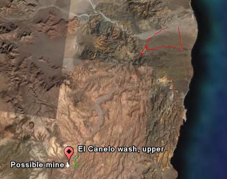
El Canelo wash
TW mentioned in another thread a mine he found on Google Earth near the upper reaches of El Canelo was in the Sierra Santa Isabela west of
Puertecitos. I drew some possible routes as tracks in Google Earth and transfered them to Ozi Explorer.
This is north of the Bill Nichols trail, leaving Hghy5 between the Matomi and Puertecitos.
Some people just can't wait. Told a few neighbors about it and they had to go yesterday. - Remember, we're in Baja Bugs and desert rails - no MCs.
There is a road into the mouth of the canyon from Hghy 5 but we only found it on our way out.
This shows where we went - from Matomi to the canyon and back out to the highway. (red) and points for the mine and upper canyon near the lower left.
This shows our gong into the mouth - about a mile from the lunch spot.
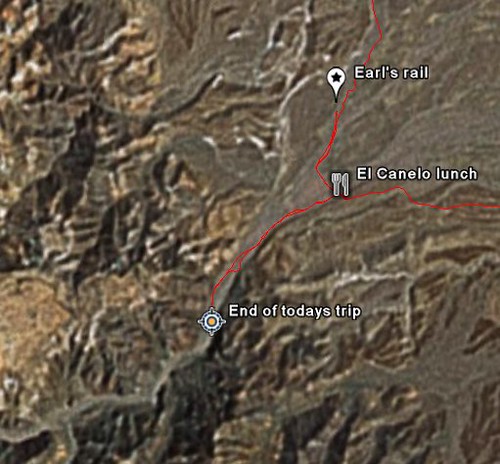
There were motorcycle tracks going on beyond where we went. Because of a broken axle on a rail and time of day we turned around there but know we can
drive further up the canyon on another day. Where we stopped we were at about 635 ft elevation. Longer days will help when we go back again.
The coords for the turn from H5 are
30 27.4765 -114 39.4075
That is Deg and min only
There is a white van just off the highway right where you turn in on the road. One "Y" in the road a mile or so in, stay to the right. The road
eventually crosses the El Canelo wash about 1/2 mile from the mouth of its canyon.
From H 5 it is about 22 miles to the curve nearest the mine. (Made a track in GoogleEarth, converted to Ozi to get measurement).
[Edited on 2-25-2007 by bajalou]
No Bad Days
\"Never argue with an idiot. People watching may not be able to tell the difference\"
\"The trouble with doing nothing is - how do I know when I\'m done?\"
Nomad Baja Interactive map
And in the San Felipe area - check out Valle Chico area |
|
|
bajalou
Ultra Nomad
Posts: 4459
Registered: 3-11-2004
Location: South of the broder
Member Is Offline
|
|
Bill Nichols Trail
Here is the Bill Nichols trail on Google Earth
No Bad Days
\"Never argue with an idiot. People watching may not be able to tell the difference\"
\"The trouble with doing nothing is - how do I know when I\'m done?\"
Nomad Baja Interactive map
And in the San Felipe area - check out Valle Chico area |
|
|
TMW
Select Nomad
Posts: 10659
Registered: 9-1-2003
Location: Bakersfield, CA
Member Is Offline
|
|
El Canelo
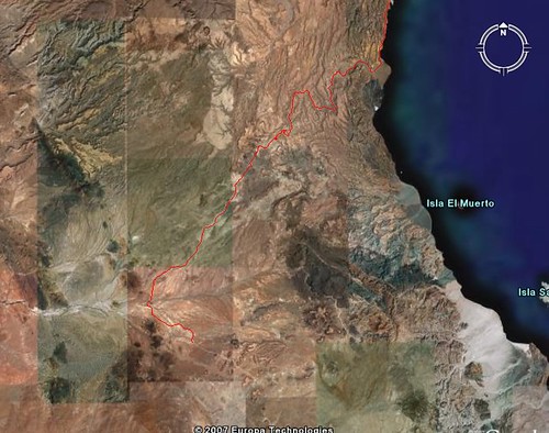
Thanks Lou here's some more satellite images from hwy 5 at Matomi to the mine.

|
|
|
TMW
Select Nomad
Posts: 10659
Registered: 9-1-2003
Location: Bakersfield, CA
Member Is Offline
|
|
El Canelo

|
|
|
TMW
Select Nomad
Posts: 10659
Registered: 9-1-2003
Location: Bakersfield, CA
Member Is Offline
|
|
El Canelo

|
|
|
TMW
Select Nomad
Posts: 10659
Registered: 9-1-2003
Location: Bakersfield, CA
Member Is Offline
|
|
El Canelo

|
|
|
TMW
Select Nomad
Posts: 10659
Registered: 9-1-2003
Location: Bakersfield, CA
Member Is Offline
|
|
Mine

|
|
|
TMW
Select Nomad
Posts: 10659
Registered: 9-1-2003
Location: Bakersfield, CA
Member Is Offline
|
|
El Canelo
[Edited on 2-25-2007 by TW]
[Edited on 2-25-2007 by TW]

|
|
|
TMW
Select Nomad
Posts: 10659
Registered: 9-1-2003
Location: Bakersfield, CA
Member Is Offline
|
|
El Canelo

|
|
|
TMW
Select Nomad
Posts: 10659
Registered: 9-1-2003
Location: Bakersfield, CA
Member Is Offline
|
|
El Canelo

|
|
|
TMW
Select Nomad
Posts: 10659
Registered: 9-1-2003
Location: Bakersfield, CA
Member Is Offline
|
|
El Canelo

|
|
|
TMW
Select Nomad
Posts: 10659
Registered: 9-1-2003
Location: Bakersfield, CA
Member Is Offline
|
|
El Canelo

|
|
|
TMW
Select Nomad
Posts: 10659
Registered: 9-1-2003
Location: Bakersfield, CA
Member Is Offline
|
|
El Canelo

|
|
|
TMW
Select Nomad
Posts: 10659
Registered: 9-1-2003
Location: Bakersfield, CA
Member Is Offline
|
|
El Canelo

|
|
|
TMW
Select Nomad
Posts: 10659
Registered: 9-1-2003
Location: Bakersfield, CA
Member Is Offline
|
|
In the Almanac it's on page 14. The mine is at 30-15-10x114-50-25 @ 2128ft. Located on page 14 at the bottom near the 114.50 mark. If you use Google
Earth you can trace the road at the mine back to hwy 1 in the Guayaquil area. I'm sure the road is the same as used in the Bill Nichols trail.
|
|
|
bajalou
Ultra Nomad
Posts: 4459
Registered: 3-11-2004
Location: South of the broder
Member Is Offline
|
|
TW, I've also traced the road from the mine to H1 and it is north of the Bill Nichols trail - I had both on the same GoogleEarth image.
The entry to El Canelo is not the best resolution. Higher resolution as you go on south in the canyon. By width etc I believe the first 4-5 miles
will be the toughest as it widens out later.
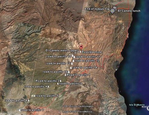
The "Road to Pacific 7" is where the mine road connects with Hghy1. The red track starting below Puertecitos is the Bill Nichols Trail.
[Edited on 2-25-2007 by bajalou]
No Bad Days
\"Never argue with an idiot. People watching may not be able to tell the difference\"
\"The trouble with doing nothing is - how do I know when I\'m done?\"
Nomad Baja Interactive map
And in the San Felipe area - check out Valle Chico area |
|
|
TMW
Select Nomad
Posts: 10659
Registered: 9-1-2003
Location: Bakersfield, CA
Member Is Offline
|
|
Lou can you overlay Bill Nichols trail in closeup quarter sections. The bottom half is easy to follow as you can see the road on the satellite images.
But the top half is difficult because it appears he followed various washes and the satellite images don't show any tracks that I could see.
|
|
|
surfer jim
Super Nomad
Posts: 1891
Registered: 8-29-2003
Location: high desert
Member Is Offline
|
|
I am watching this wishing I was driving it......love those images....
|
|
|
ArvadaGeorge
Nomad
Posts: 358
Registered: 9-2-2003
Member Is Offline
|
|
Lou
What were the cords for "end of today trip" and "earls rail" ???
I think I have done some riding there.
And I have done Bill's trail several times
|
|
|
Mexitron
Ultra Nomad
Posts: 3397
Registered: 9-21-2003
Location: Fort Worth, Texas
Member Is Offline
Mood: Happy!
|
|
Bajalou--where does the Bill Nichols trail end up at? Not familiar with it.
|
|
|
| Pages:
1
2
3
4 |


