| Pages:
1
2 |
Neal Johns
Super Nomad

Posts: 1687
Registered: 10-31-2002
Location: Lytle Creek, CA
Member Is Offline
Mood: In love!
|
|
In Search of
.#1 - El Camino Real Santa Ursula
In Search of
.#1 - El Camino Real place name Santa Ursula
This trip was a Loose ends trip to do some of the roads and places that Nomad John M and I have passed up before. Our first objective was: Santa
Ursula.
Santa Ursula was/is a waterhole/camping spot on the ECR between Mission San Fernando and Mission El Rosario. It has long intrigued me because it
seemed to be far into the boonies and not very well known these days. Using Harry Crosbys maps and the Baja Almanac and Google Earth I found some
evidence of habitation sites within a few miles of where Harrys rather course map indicated. However, David K found a road log of the premier
guidebook writer Howard Gulicks early trip to Santa Ursula. This showed that it was only a few miles south of Hwy. 1 about 20 miles south of El
Rosario. A drive to the area by David missed one turn and he challenged me to find it. A challenge! The nerve of that young whippersnapper!
I assembled a crack support team to help make sure my aging body could make it there and back and we were off for ten days of Baja Exploration. It
just doesnt get better than that!
The guilty party consisted of myself and co-leader Nomad John M, history buff, author, and ultra-marathon runner and his wife, Barbara the cookie
lady; Skip, a veteran Baja traveler; Bob, likewise; Bill the Rokon Guy form Texas, Dale, a newbie to Baja with a Jeep towing a small off-road trailer;
and of course, my current wife, Marian who first Jeeped Baja in the 60s.
We camped near the border by Tecate in the Potreo County Park and it is a beautiful place, even if the wind was howling. The next morning we crossed
and headed south. That first night we took over the parking lot of the BajaCactus Motel in El Rosario and felt we were finally in Baja! This was my
first stay in Antonios motel and it exceeded all my standards! Wow, what a great place for $35. No charge for the wife or dog, either!
The next day we drove down Hwy. 1 about 20 miles to where the road south is marked Rancho Los Martires and followed David Ks map to Santa Ursula.
Simple. Sure, I missed the right turn off of the main track shortly after passing a large plowed field and ranch (Rancho Los Martires?) at point B on
Davids map, but being smarter and more handsome than DK, I turned around in a few hundred yards, returned to near the ranch and went southwest on a
faint, at first gravely, track. In about three miles, we were at Gulicks Santa Ursula. 29deg 59min 115deg 22.5min. Datum WGS84 (for Google Earth
users) There were two abandoned shacks, two palm trees, a rock corral, and a fair amount of flowing water in Arroyo La Burro where Santa Ursula was
located. There was little sign of where the adobe that Gulick found was located. There was also no one sighted on this leg of our trip to ask
questions of. However, the route matched Gulicks mileage so we are confident that We Found It, DK!
David K's marked up map is below:
[Edited on 3-17-2007 by Neal Johns]

My motto:
Never let a Dragon pass by without pulling its tail!
|
|
|
Neal Johns
Super Nomad
Posts: 1687
Registered: 10-31-2002
Location: Lytle Creek, CA
Member Is Offline
Mood: In love!
|
|
John M, do you have any good pics of Santa Ursula?
My motto:
Never let a Dragon pass by without pulling its tail!
|
|
|
John M
Super Nomad
Posts: 1907
Registered: 9-3-2003
Location: California High Desert
Member Is Offline
|
|
Gulick's Santa Ursula
Yes Neal I have a few photos.
Problem is that the files were so big that when I reduced them to the kb necessary for posting they came up pretty small. I'll post 'em anyway. (They
are around a 4 mb file each initially!) - I previewed this post an my gosh the photos are tiny!
This first is a stone corral very near the lower ranch buildings, just above the start of the flowing stream.
John M
[Edited on 3-15-2007 by John M]
[Edited on 3-16-2007 by John M]

|
|
|
John M
Super Nomad
Posts: 1907
Registered: 9-3-2003
Location: California High Desert
Member Is Offline
|
|
Santa Urusla photo # 2
This shows the stream below the stone corral, looking upstream, back toward the ranch buildings. We found no sign of petrogylphs. Neal and Bill walked
a ways downstream, encountering a couple of palms.
[Edited on 3-15-2007 by John M]
[Edited on 3-15-2007 by John M]
[Edited on 3-16-2007 by John M]

|
|
|
John M
Super Nomad
Posts: 1907
Registered: 9-3-2003
Location: California High Desert
Member Is Offline
|
|
Ranch area, Santa Ursula
This photo shows the group as we were preparing to continue on to San Juan de Dios.
At this place we found it to be interesting and worth investigating further.
There was evidence of a stone dam along the water course and we saw the remnants of a shallow well, both matching Gulick's notes of what he had found
here in the 50s.
Also, helping to try to figure out if this was the Santa Ursula of Fr. Palou's journey north, we have portions from his diary in which Fr. Zephyrin
Englehardt reports: "Fr. Palou left San Fernando Velicata at about one oclock in the afternoon of July 21, 1773.The whole party camped for the night
at a place called Santa Ursula."
Taking GoogleEarth and measuring distance along what may be parts of the ECR, I found the distance from San Fernando to this spot to be about 9 miles
- a doable distance for a half-day's journey - plus this appears to be the first significant water along the route.
John M
[Edited on 3-16-2007 by John M]

|
|
|
David K
Honored Nomad
Posts: 64490
Registered: 8-30-2002
Location: San Diego County
Member Is Offline
Mood: Have Baja Fever
|
|
Excellent work guys!!!
My search was described at http://vivabaja.com/406 and after coming home and making a map of our drives in those hills, I came to the conclusion that Santa Ursula was indeed
on the road to the west of the one I was on, at Arroyo La Burra.
Congratulations on making the discovery!
John, please email me the photos and I will resize them for Nomad, for you.
Great stuff!!!
|
|
|
Neal Johns
Super Nomad
Posts: 1687
Registered: 10-31-2002
Location: Lytle Creek, CA
Member Is Offline
Mood: In love!
|
|
Good job resizing the pictures, John. Thanks.
My motto:
Never let a Dragon pass by without pulling its tail!
|
|
|
David K
Honored Nomad
Posts: 64490
Registered: 8-30-2002
Location: San Diego County
Member Is Offline
Mood: Have Baja Fever
|
|
Yes John... thanks for making them bigger!
Neal, you have photos of the palms?
Did you hike any of the Camino Real... which won't look like any more than a deeply worn cattle trail there?
|
|
|
David K
Honored Nomad
Posts: 64490
Registered: 8-30-2002
Location: San Diego County
Member Is Offline
Mood: Have Baja Fever
|
|
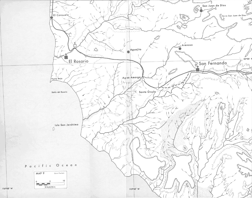
Howard Gulick's El Camino Real maps are viewable at http://vivabaja.com/ECR/page12.html
Here is the northern area, with Santa Ursula shown (between San Fernando and El Rosario):

[Edited on 12-28-2019 by David K]
|
|
|
David K
Honored Nomad
Posts: 64490
Registered: 8-30-2002
Location: San Diego County
Member Is Offline
Mood: Have Baja Fever
|
|
Here's Harry Crosby's El Camino Real map of the Santa Ursula area...
[Edited on 12-28-2019 by David K]
|
|
|
Neal Johns
Super Nomad
Posts: 1687
Registered: 10-31-2002
Location: Lytle Creek, CA
Member Is Offline
Mood: In love!
|
|
David K, we did not spend time looking for the ECR and I have no pictures of the two palms.
Note that on Crosby's map, Santa Ursula appears to be on a side arroyo of Canyon San Fernando rather that a limb (La Burra) of Canyon San Vicente
where we found Gulick's Santa Ursula. Too bad we did not run into any locals to find out what the name of the abandoned rancho was.
My motto:
Never let a Dragon pass by without pulling its tail!
|
|
|
David K
Honored Nomad
Posts: 64490
Registered: 8-30-2002
Location: San Diego County
Member Is Offline
Mood: Have Baja Fever
|
|
Here's the map from my 406 web page, with Neal & John's location of Santa Ursula indicated...

|
|
|
David K
Honored Nomad
Posts: 64490
Registered: 8-30-2002
Location: San Diego County
Member Is Offline
Mood: Have Baja Fever
|
|
10-4 Neal... Howard Gulick has the location better shown in his 1953 map, since he drove there.
Harry's maps were prepared for him based on his notes... It does show Santa Ursula too far south. Harry's interests were also on Junipero Serra's
route, which went north from San Fernando to San Juan de Dios.
Once the Dominicans established the El Rosario mission in 1774, then traffic would pass Santa Ursula and the other points on the Camino Real.
|
|
|
John M
Super Nomad
Posts: 1907
Registered: 9-3-2003
Location: California High Desert
Member Is Offline
|
|
Cattle trail into Santa Ursula
Here is a photo of a cattle trail leading directly to the water from the south. This trail is alongside the westernmost line shack buildings.
I tried to post a map but it was rejected, I'll try later.
John M

|
|
|
John M
Super Nomad
Posts: 1907
Registered: 9-3-2003
Location: California High Desert
Member Is Offline
|
|
Screen shot image
attached is a google earth image of this area. The cattle trail in the previous post is marked, and leads directly south from the westernmost line
shack.
To the right, a path or faint roadway follows a water course also leading from the south into the Santa Ursula complex. This "road" can be followed,
mostly, directly to San Fernando Mission with only a couple of areas not visable. Could this have been the ECR?
Tomorrow I will attempt to make this image clearer.
John M
[Edited on 3-16-2007 by John M]
[Edited on 3-16-2007 by John M]

|
|
|
David K
Honored Nomad
Posts: 64490
Registered: 8-30-2002
Location: San Diego County
Member Is Offline
Mood: Have Baja Fever
|
|
John, I will do a flyover with Google, but based on what I believe to be the facts, the Camino Real would be coming into Santa Ursula from the east,
not the south. The road goes south then curves east to my point 'C' on the map (on the newer, unmapped road I was on).
|
|
|
Neal Johns
Super Nomad
Posts: 1687
Registered: 10-31-2002
Location: Lytle Creek, CA
Member Is Offline
Mood: In love!
|
|
Harry Crosby's maps were drawn with great care using the best maps available at that time. The following quotes are from the Winter 1977 Journal of
San Diego History:
"Crosby's companion on the 1967 trip was Dr. Paul B. Ganster (now professor of history at Utah State University). Ganster kept a detailed set of trail
notes which included all the placenames available from local people, and a set of sketch maps which showed the complexities of trail and terrain."
Dr. Ganster is currently Director of the Institute for Regional Studies of the Californias.
"The series of twelve new maps presented here was prepared by Daira Paulson who worked closely with the author to create this graphic presentation of
his data. (Ms. Paulson is a graduate student in geography with emphasis in cartography at San Diego State University.) The base map from which this
was developed was that published by: "Comision Intersecretarial Coordinadora del Levantamiento de la Carta Geografica de la Republica Mexicana,
Primera Edicion: Terminada y Publicada en 1958" (scale 1:500,000)."
"In some critical locations the watercourse data has been refined by using aerial photographs. In addition, these photographs have been laboriously
analyzed from visible muestras or showings of El Camino Real. Wherever they could be found they were used in placing the trail on the final map. Paul
Ganster's field notes and sketch maps have also been extensively compared and have been invaluable in relating the trail followed to mapped
topography."
My motto:
Never let a Dragon pass by without pulling its tail!
|
|
|
David K
Honored Nomad
Posts: 64490
Registered: 8-30-2002
Location: San Diego County
Member Is Offline
Mood: Have Baja Fever
|
|
Also of interest was Harry used Howard Gulick's maps, notes, and personal conversations to assist in his research and writing of 'The King's Highway
in Baja California'.
|
|
|
David K
Honored Nomad
Posts: 64490
Registered: 8-30-2002
Location: San Diego County
Member Is Offline
Mood: Have Baja Fever
|
|
Okay, here are the satellite photos for the points on the map...
A (Hwy. 1 by El Arenoso ruins): A
B (Fork with other road from Hwy. 1 near Los Martires road Cafe): B
C (cross road, to Santa Ursula, turn west): C
D (Faint fork for Points E or F): D
E (End of road by arroyo): E
F (End of road at rock mine above Cañon San Fernando): F
G (near end of road at base of hill): G
H (Road jcn. from mines): H
I (Hwy. 1 near Los Martires & San Juan de Dios road cafe): I
Santa Ursula: Santa Ursula
After 'flying over' the roads I drove last year, and seeing the region better, I see that my 'Point C' (on the map) should be about 1/2-3/4 mile
further east, on the shown road to 'Point G', just to the east on the south to east bend.
[Edited on 3-16-2007 by David K]

|
|
|
Neal Johns
Super Nomad
Posts: 1687
Registered: 10-31-2002
Location: Lytle Creek, CA
Member Is Offline
Mood: In love!
|
|
OK, time out from all this dull history jazz, lets have some fun!
What do we do with Baja Newbies like Dale? A super nice guy but what are Newbies for if they are not stuck? I made a wrong decision (I know, I know,
Real Aridologists do not make mistakes) and took an old route to San Juan de Dios via the sand wash of Arroyo San Juan de Dios.
I was doing fine in my Tacoma Pop-top camper and saw no reason to mention that I was running marshmellows on 15 inch rims. Technically they are known
as BFG All Terrain 33x12:50x15 and fill up the wheelwells to overflowing.
Below is a picture of Poor Old Dale (POD) in his Heep. Are you watching, Ken Cooke? 

My motto:
Never let a Dragon pass by without pulling its tail!
|
|
|
| Pages:
1
2 |


