| Pages:
1
2 |
Neal Johns
Super Nomad

Posts: 1687
Registered: 10-31-2002
Location: Lytle Creek, CA
Member Is Offline
Mood: In love!
|
|
In Search of
.#5 Canyons Carrizo and Berrendo
Arriving in San Felipe, we gassed up and then camped in a nice sand wash just west of where Zoo Road and the Dump Road come together (In my single
days a few decades ago, I would get into San Felipe at night and camp in the dump :lol The next morning we headed west and south down to the bottom of Valley Chico. The next morning we headed west and south down to the bottom of Valley Chico.
The road to Rancho Morelia was in outstanding shape so we zoomed right along. We drove through the corrals and few houses of Agua Caliente and took
the faint, sand covered road south. Having been there before was a big help because of the blow sand covered road. We soon came to Carricitos which
you cant miss because it is a large corral with a small house hidden behind it. We did a clockwise 270 degree spin around the corral, passing the
house, and took the road west to Canyon Carrizo. Parking at the end of the road, we hiked up canyon a few tenths of a mile and found out how old I
was. I tried to blame it on the heat, but that didnt fly. People are so cruel to harmless old men. 
After driving back to Carricitos, we took the road toward Canyon Matomi as I had thoughtfully left David Ks great hand drawn map of the area at home.
It is re-posted below for travelers in this area. Another great resource is Bruce Barbers book on the San Felipe area, Of Sea and Sand.
Before too long, we came to the roadless mouth of a canyon that had to be Berrendo. We had lunch under the shade of a small tree and then drove up the
sandy canyon after airing down. In a mile or two, Surprise! We hit a well defined sandy road. We followed it as far as it would go up canyon and were
rewarded with a lot of blue palms both in the canyon and well up on the sides of the canyon. Suspecting that the road had a junction that went north
to Carricitos, we went north and were soon rewarded with the sight of the corral with a gentleman working in it. We bid him a Buenos Tardes and went
into San Felipe for dinner at Nidos (Georges is better but we wrongly thought it was closed). Stuffed, it was back to the sand wash to camp before
heading for our next goal.

My motto:
Never let a Dragon pass by without pulling its tail!
|
|
|
Neal Johns
Super Nomad
Posts: 1687
Registered: 10-31-2002
Location: Lytle Creek, CA
Member Is Offline
Mood: In love!
|
|
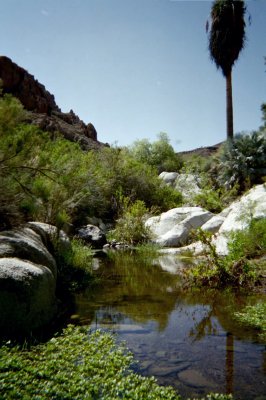
Canyon Berrendo Palms

My motto:
Never let a Dragon pass by without pulling its tail!
|
|
|
Neal Johns
Super Nomad
Posts: 1687
Registered: 10-31-2002
Location: Lytle Creek, CA
Member Is Offline
Mood: In love!
|
|
More Canyon Berrendo Palms

My motto:
Never let a Dragon pass by without pulling its tail!
|
|
|
Neal Johns
Super Nomad
Posts: 1687
Registered: 10-31-2002
Location: Lytle Creek, CA
Member Is Offline
Mood: In love!
|
|
Grinding slicks near end of Canyon Berrendo.

My motto:
Never let a Dragon pass by without pulling its tail!
|
|
|
Skipjack Joe
Elite Nomad
Posts: 8088
Registered: 7-12-2004
Location: Bahia Asuncion
Member Is Offline
|
|
I've never seen fan palms growing anywhere other than on the floor of a dry riverbed. Yet there they are so far above ground water. Learned something
today.
|
|
|
Iflyfish
Ultra Nomad
Posts: 3747
Registered: 10-17-2006
Member Is Offline
|
|
Great pics. Amazing what one can run into off road. Thanks for sharing this.
Iflyfish
|
|
|
Mexitron
Ultra Nomad
Posts: 3397
Registered: 9-21-2003
Location: Fort Worth, Texas
Member Is Offline
Mood: Happy!
|
|
| Quote: | Originally posted by Skipjack Joe
I've never seen fan palms growing anywhere other than on the floor of a dry riverbed. Yet there they are so far above ground water. Learned something
today. |
I've been consistently amazed to find Blue Palms growing on the tops of dry mesas, at high elevations with winter snow, mixed in with Pinion/Juniper
Woodland and as in Berrendo--all over the place! Here's one small one on the top of the dry lava Matomi Mesa at around 4,200'. That's San Juan Del
Dios in the distance.
[Edited on 3-19-2007 by Mexitron]

|
|
|
Barry A.
Select Nomad
Posts: 10007
Registered: 11-30-2003
Location: Redding, Northern CA
Member Is Offline
Mood: optimistic
|
|
It is my understanding that the Blue Palms high on both sides of Berrendo Wash are growing there because of a series of low-volume springs along a
huge "fault" that traverses Berrendo at about right angles, there.
Neal-------it is interesting to now know that you can drive that part of Berrendo below the "Carricitos to Parral Canyon" road and the old road direct
to Matomi from Carricitos. That should be a really nice (tho short) stretch of canyon, es verdad?
Also, reference Carrizo-------- if you hike up Carrizo just a little ways beyond the end of the road, and then up the side canyon to the south, you
will find a really nice grove of palms (circa 2000). Again, it is my understanding that most of the main Carrizo Canyon palms have been destroyed in
the several gully-washers that have happened in the past 30 years from Tropical Storms, most notably Tropical Storm KATHLEEN in 1976. When I first
visited Carrizo in about 1963 there were many more palms in the canyons than now. Edward "Bud" Bernhard of Coronado hiked all these Canyons in the
late ' 50's and early 60's, and his hand-drawn map (which I have a copy of) reveals that he counted in excess of 5000 (that is 5 plus 3 zeros) palms
collectively in Carrizo, Berrendo (which he called "Barrosa"), and Parral Canyons. I did not personally count them on my first visit in 1963, but I
think that Bud was spot-on in his estimate.
To me, this is some of the "best of Baja" country, and truly almost National Park quality. The Blue Palms of Berrendo are amazing, and the entire
wash is beautiful, and emense. Most of the time the sands of Berrendo are so soft that I do recommend 4-wheel drive, but after rains you can go up it
in 2-wheel drive if careful, and with a buddy vehicle.
|
|
|
Barry A.
Select Nomad
Posts: 10007
Registered: 11-30-2003
Location: Redding, Northern CA
Member Is Offline
Mood: optimistic
|
|
Agua at Carricitos???
Neal------
Last time I was at Carricitos (in 2004) there was plentiful water running, and a big trough full of water. The water came from a pipe that I believe
originated in the lower reaches of Carrizo canyon.
Question: was there flowing water there this time?? (we always filled our sun-showers there)
|
|
|
Mexitron
Ultra Nomad
Posts: 3397
Registered: 9-21-2003
Location: Fort Worth, Texas
Member Is Offline
Mood: Happy!
|
|
Barry--you may be right about springs in Berrendo but its hard to believe there are springs coming out of that whole area...the granite may retain
water in the crevices of that area perhaps. I think too they are just a very hardy palm with very deep root systems. I can almost guarantee there
isn't any spring water on the top edge of the Matomi Mesa but there it grows!
|
|
|
Barry A.
Select Nomad
Posts: 10007
Registered: 11-30-2003
Location: Redding, Northern CA
Member Is Offline
Mood: optimistic
|
|
Mexitron---------yeah, your plateau-top palm DID bother me too, and I was trying to ignor it!
I have no explanation---------as I have NEVER seen a mountaintop palm growing, like that one. Your "catch-basin" amongst the granite is a real
possibility, for both the Berrendo Palms, and your mountaintop aberation (you planted it, right???)
But I can see with my highly educated (???) eyes that, in fact, a very large and fractured "fault" runs thru the area of Barrendo that has the Palms
up the sides of the canyon. I have seldom seen other palms growing like that on canyon sides in such random manner. Quien Sabe?
|
|
|
Mexitron
Ultra Nomad
Posts: 3397
Registered: 9-21-2003
Location: Fort Worth, Texas
Member Is Offline
Mood: Happy!
|
|
Given their druthers I think they'd like a constant source of moisture...but, yup, quien sabe?! Next time you drive up the Rumorosa Grade you can see
some small palms growing near the top--must be at least 4,500 feet there--just scatterred about in the chapparal.
|
|
|
Cypress
Elite Nomad
Posts: 7641
Registered: 3-12-2006
Location: on the bayou
Member Is Offline
Mood: undecided
|
|
Neal Johns, Looks like ya'll were in some tuff country. Thanks for the
pics. Thanks for the
pics.
|
|
|
Neal Johns
Super Nomad
Posts: 1687
Registered: 10-31-2002
Location: Lytle Creek, CA
Member Is Offline
Mood: In love!
|
|
The drive up the bottom of Berrendo from the Matomi road was very easy. The summer heat to come has not yet cooked the moisture out of the sand so it
was fairly firm with no rocks. We aired down, however. I ran 23 lb. rear and 20 lb. front in BFG All Terrain 33x12:50x15 tires and drove home with
that pressure under my Tacoma/Pop-top. BFG's are tough.
There was water at Carricitos as evidenced by all the cows, cow patties and hoof prints. We did not hike up far enough in either canyon to get to the water. It had not rained there in a while. We did not hike up far enough in either canyon to get to the water. It had not rained there in a while.
Tuff country? Nope, kind of out-of-the-way, but easy driving. Marian even let me drive some!
My motto:
Never let a Dragon pass by without pulling its tail!
|
|
|
David K
Honored Nomad
Posts: 65366
Registered: 8-30-2002
Location: San Diego County
Member Is Offline
Mood: Have Baja Fever
|
|
Thanks Neal for the report and photos...
Elizabeth and I went to Berrendo a year ago (my second time there)... It is blue palm heaven!

The (blue palm) grotto at Berrendo canyon! More photos at http://vivabaja.com/106/page3.html
Blue palms do grow in many places on the sides of granite cliffs, because the granite holds water like a sponge! Otherwise, only in wet arroyos!
I will add a couple photos of this neat feature of Baja...


The above two photos taken a few miles northwest of Tinaja de Yubay, I call the site 'Rock Palm Hill' a really amazing place... many more blue palms
on the mountainside then shown!

These blue palms growing high above the valley were spotted by 'jide' as we drove north from Parral to Berrendo...
Barry, the original road between Parral and Matomi (shown in the Almanac still) is not passable per bajalou. I didn't see any activity on it either
when we went to Parral in '04.
Neal, so no look at La Turquesa shortcut, afterall?
[Edited on 3-19-2007 by David K]
[Edited on 3-19-2007 by David K]
|
|
|
Barry A.
Select Nomad
Posts: 10007
Registered: 11-30-2003
Location: Redding, Northern CA
Member Is Offline
Mood: optimistic
|
|
David K------
The road shown in the Almanac going down Parral Canyon was not passible in 2000, either, and it looked like it had just washed out before we got
there. I have driven that road in the far past, but not lately, obviously, as it no longer exists.
The road directly from Carricitos to Matomi which leaves Carricitos in an ESE direction was there in 1998, and was well established at that time.
That road, for some reason, has never showed up in the "Almanac", but it is the "main" road between Carricitos and Matomi, as I am sure you know.
I am under the impression that the road up Parral Canyon from the now "main road to Matomi" was "there" and passible in 1996, as I remember seeing
tracks on it as we passed by Parral on our way to Matomi------but we did not drive up it to see if it went thru.
AS you know, the road directly from Carricitos to Parral Canyon (as shown in the Almanac) is such a good road, albiet a desert track, that I guess
there is no incentive to move a billion rocks out of the way to open up the down-canyon portion of the old Parral Canyon road.
As I believe I told you in the past, when I was in Parral in 2000 we were unable to drive up Parral from the Junction of Parral Canyon and the road
from Carricitos, as it was heavily gated with many locks. I have never been to El Parral, therefore. I understand that you have been there, and the
gates are now open. Es Verdad??
|
|
|
David K
Honored Nomad
Posts: 65366
Registered: 8-30-2002
Location: San Diego County
Member Is Offline
Mood: Have Baja Fever
|
|
The 'main' Valle Chico road is indeed the one that makes a sharp eastward bend just north of the Carricitos corral (see my 2004 map) then again bends
south (avoiding a mountain) to head straight to Matomi canyon... I have driven it often since the first time in 1978... Yet, AAA or Mexican topos
(Baja Almanac) can't seem to find it! AAA shows the road ending at Agua Caliente!
The gate at the entrance to Parral canyon was open in 2004... We met bajalou, Mexitron, Pappy, Taco de baja and others that day , see photos: http://www.vivabaja.com/404/
We could drive a short ways past the gate to the corral which is on the road! Drive through the corral, and the drivable road ends a half mile beyond
at the major washout.
The hike to old Rancho Parral was one mile... really beautiful up there!

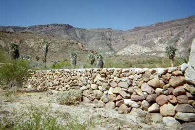
These walls can be seen on Google satellite!
We were just lucky to find the gates open!
|
|
|
Neal Johns
Super Nomad
Posts: 1687
Registered: 10-31-2002
Location: Lytle Creek, CA
Member Is Offline
Mood: In love!
|
|
David K, we went to La Turquesa and had a look at the Hwy. 5 to Hwy. 1 shortcut. Here is how to do it westbound (but my crack crew bailed out to camp
early at Campo Beluga, so we only looked - no pics):
Continue past the pools over the slickrock and road on the left side of the canyon. In a few tenths of a mile, the road crosses the canyon. Don't
cross (you end up on a bench at the mine), instead start driving up the canyon/wash for a mile and a half to the bottom of the hill you hiked down. To
do this, you need a walker out front with a handheld radio to prevent a lot of backtracking from going up blind leads. It will be slow, but the half
mile I walked/looked at was not very difficult. Wild Bill phoned me from on the road, a couple of days ago and said he and DB used walkers also.
We were going to do it westbound because the wash was presumed to be the difficult part and if we got skunked, we wanted to have less of a drive out.
My motto:
Never let a Dragon pass by without pulling its tail!
|
|
|
David K
Honored Nomad
Posts: 65366
Registered: 8-30-2002
Location: San Diego County
Member Is Offline
Mood: Have Baja Fever
|
|
Thanks Neal... I already heard rumors that SCORE was going to check the route for possible Baja 1000 use!
If brush isn't a problem between the turquoise mine and the bottom of the grade, then (I wonder) how does the bottom of the grade look? Any short
steep dropoff from erosion/ flash flood? Or can we take our Toyotas and just drive up to Hwy. 1? I see you didn't walk or drive all the way to the
base of the grade (shame, shame)...
The only reason Baja Angel and I did not drive down it from the top last month was the uncertainty of the bottom half-mile, that was beyond my view
and I just didn't want to walk any further down the mountain (and then have to climb back up)!
Yes, a few rocks will need to be pushed off the road... But it was wide enough (just enough) without being dangerous.
We didn't drive down it because we couldn't see any turn around, should we come to a drop off or wash out .
Better with a buddy rig on the first trip!
[Edited on 3-20-2007 by David K]

|
|
|
David K
Honored Nomad
Posts: 65366
Registered: 8-30-2002
Location: San Diego County
Member Is Offline
Mood: Have Baja Fever
|
|
Another look down

|
|
|
| Pages:
1
2 |


