| Pages:
1
2 |
Neal Johns
Super Nomad

Posts: 1687
Registered: 10-31-2002
Location: Lytle Creek, CA
Member Is Offline
Mood: In love!
|
|
In Search of
. #6 Pole Line Road Washout
I wanted to see exactly where the bypass to the washout was that cut the route from the end of the Pole Line Road south toward San Felipe. So off we
went via La Ventana.
La Ventana is more than just a store on the AAA map and Hwy. 5. It is just what its name is; a window west through the mountain range to the interior
valley. The easy access to the road from Hwy. 5 is where the arroyo draining the window crosses the highway at N31deg 43.863min W115deg 03.880min
Datum NAD27 Mexico. This is a few tenths south of the store. The road is in great shape because the mine just north of the Hwy. 5/Hwy. 3 intersection
uses it for access to their water pipeline from their well in the middle of the valley to the mine.
The new graded road, jogs left just before a ditched airfield, while the old road continued west a few more tenths before jogging left. After hitting
the west bound pipeline the road and pipeline follows the old road out to the middle of the valley. As the mountains are cleared, you cross the
north/south race course and continue to the middle of the valley where the well is. At the well, the road turns left, south, to go up the hardly
recognizable Arroyo Grande. Here, Arroyo Grande does not live up to its name; just a diffuse, sandy area of many little washes.
Knowing we wanted to stay near the right side of the wash, we followed a fainter track south, a little west, off the main tracks and were soon
rewarded by having a two foot bank of the deepening arroyo on our right side. When we came to the crossroad and cairns on each side of the Arroyo
Grande western bank go-up, I started breathing again and confidently stated Yep, I knew it was here. Never let them see you sweat. West Bank Go-Up
at N31 37.543 W115 15.713.
After going up the west bank, the rough, seldom used road turned north against the side of the hill. A treat here is a wide spot with a cut-off pole
from the Pole Line Road in it. This used to be a pit area for the Baja race.
Continuing a short distance around the end of the hill and you come abruptly to a vertical arroyo bank where the road was cut at an angle into its
side. Whoa! This was the washout we were looking for, and it had no protection for anyone not knowing it was there. The 15 foot drop might not hurt,
but the sudden stop sure would. We put large rocks across the road so people would be sure to turn north along the arroyo bank where someone had put
cairns. Washout at N31 39.111 W115 18.051
In just 300 yards right, north, there was a nice go-down at N31 39.259 W115 17.986. After re-building it a little just in case we had to get back up
it, over the falls we went, making a u-turn to drive back up the arroyo to rejoin the road at the bottom of the washout. Climbing out the far bank of
the arroyo, in 300 yards we came to the bottom junction of the Pole Line Road where you make a decision at N31 39.060 W115 18.208. Our choice was
either to go straight west into the mountains over the Pole Line Road backwards (No, no, not today), or turn right, north, to get to Hwy. 5 near Ejido
Saldana. Smoothing down our pinfeathers, we headed north and were soon on Hwy. 5. We took the free road (Hwy. 2) over the Cantu Grade (you modern kids
call it the Rumorosa Grade) to Tecate and crossed Monday with a terrible wait while the six cars in front of us were waved through.

My motto:
Never let a Dragon pass by without pulling its tail!
|
|
|
Neal Johns
Super Nomad
Posts: 1687
Registered: 10-31-2002
Location: Lytle Creek, CA
Member Is Offline
Mood: In love!
|
|
Here is Jeep driver Dale as a traffic cop:

My motto:
Never let a Dragon pass by without pulling its tail!
|
|
|
Neal Johns
Super Nomad
Posts: 1687
Registered: 10-31-2002
Location: Lytle Creek, CA
Member Is Offline
Mood: In love!
|
|
Going down!

My motto:
Never let a Dragon pass by without pulling its tail!
|
|
|
Neal Johns
Super Nomad
Posts: 1687
Registered: 10-31-2002
Location: Lytle Creek, CA
Member Is Offline
Mood: In love!
|
|
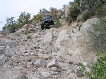
Even Heeps can make it! Go Dale, GO!

My motto:
Never let a Dragon pass by without pulling its tail!
|
|
|
TMW
Select Nomad
Posts: 10659
Registered: 9-1-2003
Location: Bakersfield, CA
Member Is Offline
|
|
Out of the wash
Thanks Neal, love your map.
This should be your WBAG point.

|
|
|
Neal Johns
Super Nomad
Posts: 1687
Registered: 10-31-2002
Location: Lytle Creek, CA
Member Is Offline
Mood: In love!
|
|
That indeed is the WBAG (West Bank Arroyo Grande) waypoint. If you squint, you can see the cairns on each side of the top of the bank.
The old race course goes east across the Arroyo Grande, over the east bank on a well defined road for about 1.4 miles then turns right, south.
Mileages from west bank below:
0.0 Enter and cross 0.6 mile wide sandy Arroyo Grande. On the far side there are deep ruts on hard surface from racing.
1.2 "Y", Go right on main road.
1.4 Edge of large wash going south (race course - may be tracks on it).
1.7 Enter sand wash going south. Many mesquites in wash.
2.7 Enter mountains.
5.2 Crest of rocky pass. Soon enter sandwash slightly downhill.
11.5 "Y", Go left, east, slightly downhill for El Chinero on Hwy. 5 or go right, south, to Hwy. 3.
17.7 (Went left east) Hwy 5 a few miles north of Hwy. 5/3 Junction.
I'll bet you have been there a few times, TW!
My motto:
Never let a Dragon pass by without pulling its tail!
|
|
|
Barry A.
Select Nomad
Posts: 10007
Registered: 11-30-2003
Location: Redding, Northern CA
Member Is Offline
Mood: optimistic
|
|
Neal and/or TW-----
Having NEVER been there, I am scrambling to understand everything you have said, Neal. Comparing the "Atlas", your posted map (which is great), and
other references including topos, I think I have put it all together now.
One question: What is "ROUT" on your posted map, Neal?
I think that "WO" is where the " old Pole line road" is washed out----correct? (WO = wash out)
That whole area between "ROUT" on the north, and "WO" on the south, is a bit confusing to me.
I am assuming that the "wash out" (of the old pole ling road?)was caused by a branch of Jaquegel wash, right?---- and you are able to cross Jaquegel
to access both parts (east portion, and west portion) of the old pole line road at different places along Jaquegel wash now, right?--- but that these
access points are fairly close to each other?
Tho you did not do it this time (and may never have done it??), is it reasonably feasible to traverse the whole pole line road from Arroyo Grande to
the base of the Sierra Juarez from East to West? I have always heard about trips going the other way, but never an "East to West" trip. What do you
think? (Ken Cook could answer this question, too, I am sure)
|
|
|
TMW
Select Nomad
Posts: 10659
Registered: 9-1-2003
Location: Bakersfield, CA
Member Is Offline
|
|
Yes Neal I've been over it many times but it was several years ago and I have forgotten most of it.
Barry the only time I have done the complete pole line road was with Ken a couple of years ago. There was nothing that I remember that would prevent
you from going east to west. However I think Ken said they moved a lot of large rocks on his last trip. Also you would need the GPS readings for the
the turns, at least the first time or two you do it.
|
|
|
Neal Johns
Super Nomad
Posts: 1687
Registered: 10-31-2002
Location: Lytle Creek, CA
Member Is Offline
Mood: In love!
|
|
Barry A.
The only thing that might slow you down going from Arroyo Grande west and north is the bad hill that in the normal direction is the last hill coming
out of the mountains and heading over the plains to Arroyo Grande. The approximately location on the Baja Almanac is 31deg 37min 115deg 20.5min
It serves as a watercourse and sometimes get two foot holes in it. Easily fixed with a little work. The first pic of the hill below is Marian driving
her Jeep down it in 1989 and the second is Marian driving our old Tacoma w/Pop-top a few years ago when we showed the route to Ken Cooke. It was in
pretty good shape then.
The washout is not in Canyon Jaquegel but in a completely different canyon, name unknown.
ROUT (Road Out) is concerned with an arroyo crossing a couple of miles past the washout where the road crosses a wide wash (Arroyo Jaquegel again).
The road across the arroyo has been washed out and the far bank road was not visible, so I walked over to where I knew it was, GPSed it, and drove to
it. Life was hard before GPS. 

My motto:
Never let a Dragon pass by without pulling its tail!
|
|
|
Neal Johns
Super Nomad
Posts: 1687
Registered: 10-31-2002
Location: Lytle Creek, CA
Member Is Offline
Mood: In love!
|
|
Here is Marian in 1989 in her Jeep.
.jpg - 26kB")
My motto:
Never let a Dragon pass by without pulling its tail!
|
|
|
Neal Johns
Super Nomad
Posts: 1687
Registered: 10-31-2002
Location: Lytle Creek, CA
Member Is Offline
Mood: In love!
|
|
Here is Marian on the same last hill a few years ago with Ken Cooke.
[Edited on 3-21-2007 by Neal Johns]

My motto:
Never let a Dragon pass by without pulling its tail!
|
|
|
Barry A.
Select Nomad
Posts: 10007
Registered: 11-30-2003
Location: Redding, Northern CA
Member Is Offline
Mood: optimistic
|
|
Neal/TW----------Ah ha---------that clears up things considerably-----thank you.
That "road" (????) in the pics is one tough road, it looks to me. A real challenge. My hat is off to Marian---------We will have to set up some kind
of "contest" between Marian and Meredith when it comes to driving the roads too rough for me (us??) to attempt------------birds of a kind, it looks to
me. 
Great graphics!!!!
Tnaks again. Barry
|
|
|
Skipjack Joe
Elite Nomad
Posts: 8088
Registered: 7-12-2004
Location: Bahia Asuncion
Member Is Offline
|
|
| Quote: | Originally posted by Neal Johns
Here is Marian in 1989 in her Jeep. |
Holy Moses! That's a road?
Is that enjoyable? I guess I would be in a constant state of anxiety worrying about the damage to my vehicle.
I suppose it's the destinations that make it all worthwhile. Or maybe it's the countryside. I have much to learn about the pleasures of offroading.
|
|
|
David K
Honored Nomad
Posts: 65298
Registered: 8-30-2002
Location: San Diego County
Member Is Offline
Mood: Have Baja Fever
|
|
Here's a ROAD!
Here's where it goes:

Here's where it ends:
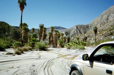
Just beautiful!!! Just BAJA!!!!
|
|
|
Barry A.
Select Nomad
Posts: 10007
Registered: 11-30-2003
Location: Redding, Northern CA
Member Is Offline
Mood: optimistic
|
|
David------------Sorry, but I have news for you---------THAT is NOT a road--------that is the side of a mountain that somebody, for some unknown
reason, decided to drive down.
But boy does that sand down by the palms look like an excellent camping place. Wow!!!!
Mission Santa Maria here we come (I wish)
|
|
|
Mexitron
Ultra Nomad
Posts: 3397
Registered: 9-21-2003
Location: Fort Worth, Texas
Member Is Offline
Mood: Happy!
|
|
Here's another nice road...if you look off to the right at the rock face angle you get an idea of the incline--and it was slippery...and it was at the
top of a 1,000' mesa.

|
|
|
Neal Johns
Super Nomad
Posts: 1687
Registered: 10-31-2002
Location: Lytle Creek, CA
Member Is Offline
Mood: In love!
|
|
Yesss, that looks like you need a locker!
By the way, it is not a good idea to travel on these kinds of roads with only one vehicle. It's a long walk out.
My motto:
Never let a Dragon pass by without pulling its tail!
|
|
|
Mexitron
Ultra Nomad
Posts: 3397
Registered: 9-21-2003
Location: Fort Worth, Texas
Member Is Offline
Mood: Happy!
|
|
That was a brand new road--only one week old! Just hacked in by the yucca harvesters to get at an upper mesa valley area. Looks like on google earth
that there are more roads in the area behind R. Metate too--Neal--did you guys see any of them when you were in the bulldozed visita site area?
|
|
|
David K
Honored Nomad
Posts: 65298
Registered: 8-30-2002
Location: San Diego County
Member Is Offline
Mood: Have Baja Fever
|
|
Pretty soon, no more Yucca trees!
God, I hope they don't find a use for boojums!!!

|
|
|
Mexitron
Ultra Nomad
Posts: 3397
Registered: 9-21-2003
Location: Fort Worth, Texas
Member Is Offline
Mood: Happy!
|
|
Yah, boojums being harvested would be a travesty! At least the Yuccas grow back, eventually. But they do keep some of the roads in shape, like the
llanerros(sp?) of old on the eastern side of the mountains.
|
|
|
| Pages:
1
2 |


