| Pages:
1
2 |
David K
Honored Nomad

Posts: 64507
Registered: 8-30-2002
Location: San Diego County
Member Is Offline
Mood: Have Baja Fever
|
|
Baja Road Logs
I am going to attempt to put all my detailed road logs (GPS and/ or mileage logs) in one place so they are easy to locate and use.
Currently they are found on my web site (vivabaja.com) and/ or here on Baja Nomad.
Please wait to post any replies or comments until I get them all up on this thread... it may take me several days...
Thanks!
Drive to BAHIA LAS ANIMAS (July, 2004)
0.0 L.A. Bay where one leaves the pavement heading south from the Xitlala (yellow) market intersection.
3.35 mi. Access road right to the Santa Marta mine tram line seen going up the mountain (next trip).
4.14 mi. Camp Gecko Driveway, office is 0.2 mi. left.
-----------------------------------------------------------------------------
0.0 Camp Gecko Driveway (28-53.96', 113-31.85' Map Datum is NAD27 Mexico)
5.7 Las Flores Jail to the west of road here
8.1 Road bends left, a 'Jeep' trail continues straight 3 miles to the end of the railroad line (terminal canyon) and bottom of the cable tram line
from the San Juan mines at the top of the mountains ( http://vivabaja.com/402/page4.html )
18.5 Old road south via Valle la Bocana (San Rafael) turns right at No Hunting sign and car door with decals. Continue straight.
22.3 Bahia las Animas road turns left, go left. (28-40.52', 113-21.72')
The 11.3 mile road in is okay for 2WD, but no low body vehicles. At each fork, keep left. Right branches go to the mud flats and may be wet during big
tide periods of the month (full and new moons). Mangroves are in the back bay at the end of the road, a small islet is off the point east of the fish
camp. GPS at the fine beach near the camp is 28-48.57', 113-21.34'
Photos at http://vivabaja.com/704
2009 update: Mysterious walls discovered in 1966 visited, some believe lost mission start and abandoned: http://vivabaja.com/109
=====================================================
To Historic Agua Dulce 11/2002 & 7/2004
On the way home from Bahia de L.A. yesterday, we took a side trip to the famous water hole on the Camino Real.
The access from the new highway was made to provide water for construction. This route was described when I last went there in November, 2002.
Neal Johns followed me in soon after and found a superior access road, which I took back out to the highway, yesterday.
Here is the post from 2002 to recap, followed by my notes on the better access...
------------------------------------------------------------------------
AGUA DULCE was an important source of water to the original inhabitants of Baja, as well as the Spanish explorers, missionairies, and early Baja
travelers. It is on the El Camino Real midway between Mision Santa Maria and Mision San Fernando Velicata. Junipero Serra and Arthur North both wrote
about Agua Dulce in their journals.
In the Baja days before Highway 1, my parents and I camped there one night, in 1966, as it was just a quarter mile off the old main road. We were in a
Jeep Wagoneer heading for the tip of Baja (a two week trip, then).
The next trip to southern Baja was in 1973, and the construction of Highway 1 was going at a feverish clip. Water was needed for constrution, so a
road was graded to the spring 2.4 miles from the new road's route. We were detoured on to this side road and ended up at Agua Dulce, again!
Unfortunately, they bulldozed the gully containing the spring and it was an 'ugly' site.
This trip, I wanted to find this (once) famous water hole, again! Using a sharp eye and noting the milage given in the Baja California Guidebook by
Wheelock and Gulick, I found the turnoff... barely! Two deep gullies almost stopped me. But, with some road-building and the Tacoma's locking rear
differential, I got through. I arrived at the old main road after about 2 miles, then the fork to Agua Dulce was a short distance beyond. I will
provide GPS and mileages at the bottom of the page.
The spring is in a gully, and vegetation had all returned. The damage done in 1973 was not noticed, even the road into the gully was greatly eroded
and only serves the cattle who come here to drink the 'sweet' water. One tall blue palm really stands out, as well. I was happy to see how well nature
reclaimed and repaired the spring. I walked down to the large pool and took some photos and GPS readings.
The next two hours, I walked the El Camino Real east, a ways (just a cow path here), then circled around the gully. I saw many clam shell fragments in
the desert, not yet fossilized. It may have been left from natives or more recent visitors, who enjoy sea food? I also climbed almost to the top of
the south mesa for a bird's eye view of Agua Dulce. That's when I noticed an Indian trail going up the opposite mesa! Baja is just so wonderful a
place for exploring... I will return to Agua Dulce!
My next stop was Rancho Santa Ynez (Ines), and I decided to use the old Baja main road as far as possible.
TO BE CONTINUED....But first...here are some GPS wayoints & milages
If you have either the Baja Almanac see map N-19(E-5) or Topo Atlas map B72(C-2). The highway is actually 1-2 miles south of where it is drawn betwen
Sonora and San Roque. The Almanac and older Topo Atlas just 'paved' the old road rather than showing the exact highway location.
The highway construction water truck road to Agua Dulce is 5.4 miles from Cafe Sonora, (Sonora is just past the signed road for El Marmol). Just past
Km. 157 the highway crosses a gully and the faint road goes off to the left (north-east). GPS (NAD27) is 29-52.59'/ 114-51.69'.
The once graded road crosses two deep washouts (4WD) and goes 1.6 miles to the old main road (29-52.99'/ 114-50.11'), where you turn right (east).
Go 0.5 mi. on the old road (note house-trailer off to right) and it brings you to the Agua Dulce road (29-52.81'/ 114-49.58') where you will turn left
(north-east).
Agua Dulce is 0.3 mile away at 29-52.97'/ 114-49.38' This waypoint is taken at the pool down in the gully. The road ends on the south side of the
gully. The tall, magestic blue fan palm will tell you you have arrived.
Back on the old road, it is a pretty good drive all the way to where it ends near the cave painting parking area/palapa two miles from Catavina. The
other direction on the old road (towards Sonora) is very bad, with deep ruts/high rocky crown. In 2000, the Baja 2000 ran through here as did the old
Baja races before Highway 1 was built.
The old southern route out from El Marmol joins in 2.4 miles from the Agua Dulce road, it is marked by a small pile of rocks (29-51.34'/ 114-48.52').
1.8 miles further is the original La Virgen shrine and once a tiny store served travelers was across the road, 29-49.87'/ 114-47.97'. A road branches
right to Highway 1, a mile away at 29-49.41'/ 114-48.63'. Continuing south on the old main road, it passes through some interesting boulder fields and
reaches Highway 1 at 29-45.15'/ 114-44.75', just north of the Pictograph parking area, or about 2.4 miles from Catavina
----------------------------------------------------------------------
July 6, 2004: We followed the above road in (along Arroyo Agua Dulce in Almanac) and barely got across one deep gully (thank you locking rear
differential). The spring was unchanged, which is good.
On the way out, we turned south on the old main road, as before. See New Baja Almanac Map 16 (E-5), however it shows the old road 'paved', when
actually the paved highway is 1.5 miles southwest and parallel to the old road.
The old road goes through a natural granite wall soon after passing the Agua Dulce 'driveway'. Just through the 'wall', a road branches right and goes
straight to the highway at 29-51.66', 114-50.35' near Arroyo Agua Chuco on the Almanac. A 'rancho' is across the highway and just west of this better
Agua Dulce road.
2005 Update:
Turn north from Hwy. 1 between Km. 160-161 (29°51.56', 114°50.35'). Go 1.4 mi. to old Baja main road , turn left for 0.3 mi. then right 0.3
more. Hike into gully. Photos at http://vivabaja.com/705/page7.html
==========================================================
Guadalupe Canyon from Hwy. 3, going down the mountain in Mano Canyon! (June, 2003)
Last June, after watching the Baja 500 race with my son, http://vivabaja.com/500 we continued east to drop off the Sierra Juarez to the desert below, then turned north to camp at Guadalupe Canyon Hot
Springs.
The road is shown in the AAA Baja map and Baja Almanac topo map book http://www.baja-almanac.com You may follow along with either, but the Almanac offers superior details, although not totally accurate.
My GPS waypoints are at map datum setting NAD27 Mexico (same as the Almanac).
On the AAA map, note the following ranchos: Agua Blanca (just east of Hwy. 3, opposite the road to El Alamo); Los Pinos; Cerro Prieto; El Mano; and
the 'Locked Gate' (it's not).
Leaving Hwy. 3 near the El Alamo turnoff, we followed the race course (not on maps) east from Hwy. 3 to a point just north of Agua Blanca and made
camp near a cross road, where the race course turned left/east. Our camp near this crossroad was at 31-42.24'/ 115-54.75' elev. 4,005'.
After the race, we followed the course from that 'left turn' and went up CANADA LAS CORDONICES 5.2 miles (map 8, R-1, Baja Almanac) to...
A junction near ARROYO EL TULE at 31-45.20'/ 115-51.52' elev. 4,663' (Almanac page 6, R-6, bottom edge) The race course turned right (south) here, we
continued ahead.
The main traveled road eventually curves eastward through the forest (not shown in Almanac).
Road again turns north at 31-47.89'/ 115-49.25', elev. 5,009'. We just followed the road with visual signs having the most traffic, going the general
direction we sought, and it took us the right way.
Soon the road turned to the east, and we arrived at the big RANCHO LOS PINOS (shown on AAA map, but not the Almanac) at 31-48.77'/ 115-46.26', elev.
5,086'. The peak CERRO PRIETO is just north of the ranch. Drive right through ranch property, going east.
Road curves north passing the north side of RANCHO CERRO PRIETO (31-49.23'/ 115-45.34') then turns east (not shown in Almanac continuing east).
Great view looking north along the east side of Sierra Juarez, down CANON EL PALMAR 31-49.12'/ 115-43.01'.
Road climbs a ridge and then drops into the upper end of CANON EL MANO for a long, steep down grade. Painted arrows (graffiti) on boulders from SCORE
indicates this was a race course, in the past.
RANCHO EL MANO is seen down in the canyon near some palms, driveway at 31-48.56'/ 115-40.39' near canyon floor.
The road will climb out of El Mano canyon, over the north ridge. Some concrete was dumped for improved traction on a steep pitch. The 'Locked Gate' on
the AAA map is a steel cable gate and was not locked or even closed.
The road descends the remaining slopes of the Sierra Juarez and is quite rough heading for the desert floor.
Once at the bottom, the road heads east to a junction with a faint road that continues south along the foot of the sierra, at 31-49.81'/ 115-33.89',
elev. 1,271' Turn north, following the arroyo.
COHABUZO JUNCTION 31-55.74'/ 115-36.22', elev. 860'. This point is not named on the map, but is the name used by off road racers (Located to the east
of the airplane symbol in the Almanac, and east of Cerro Cohabuzo in the AAA map). Here is a large level area where pit teams can service their
racers. A poor road and race route goes east to the Laguna Salada basin, joins a good road to Ejido Saldana, and reaches Highway 5 (midway between
Mexicali and San Felipe).
From Cohabuzo Junction north to Guadalupe Canyon's access is a fast graded road. Cohabuzo to Guadalupe is 29 miles.
Our Baja 500 camp (near Agua Blanca) to Cohabuzo was 36 miles, but don't be in a hurry... this is a great short cut in miles, but not in driving time!
Have a great Baja adventure!
====================================================
GPS DIRECTIONS TO TINAJA DE YUBAY (WGS 84)
JCN. hwy.1 & L.A. Bay hwy. N29°02.76' W114°09.17' 0.0 mi.
TURN NORTH onto dirt road N29°04.31' W114°02.41' 7.0 mi.
FORK right (left is Desengano, 0.3 mi.) N29°06.84' W114°01.65' 10.0 mi.
JCN. go right (ahead to rock palm hill, 4.2 mi.) N29°09.17' W114°01.40' 12.8 mi.
RIDGE TOP, 4WD only beyond N29°10.19' W113°59.77' 14.8 mi.
END OF ROAD in arroyo/TRAIL is straight across N29°10.29' W113°59.65' 14.9 mi.
TINAJA DE YUBAY N29°10.69' W113°59.26' 15.5 mi.
note: milages are direct, not road miles.
========================================================
GPS DIRECTIONS: L.A. BAY & SOUTH (WGS 84)
Hunfreville's Hut site at Las Cuevitas: N29°03.30' W113°32.35'
Casa Diaz, Bahia de los Angeles: N28°56.77' W113°33.55'
Camp Gecko, south of town: N28°54.05' W113°31.73'
Las Flores (jail house): N28°49.10' W113°31.77'
Jcn. with old road south: N28°40.77' W113°25.45'
Arroyo to Las Venecas: N28°39.40' W113°25.86'
Site of Paredones, Jesus' ranch: N28°36.81' W113°24.59'
Road ahead to La Bocana & San Pedro, turn sharp left (east): N28°28.40' W113°23.47'
We turn right, off road here: N28°28.01' W113°20.46'
Tinaja de Santa Maria: N28°26.09' W113°20.02'
=======================================================
GPS Directions for Camino Real hike to Mision Santa Maria(map datum NAD27 Mexico)
Take Hwy. 5 south 7.4 miles from Rancho Grande, turn west: 29°41.094'/ 114°24.566'
3.2 miles west of Hwy. 5, go straight where most traffic curves left for Las Palmitas: 29°41.278'/ 114°27.639'
0.8 miles from above, park at huge boulder: 29°41.68'/ 114°28.20'
Hike to north bank of Arroyo Santa Maria to: 29°41.733'/ 114°28.175' elev. 609' (ECR-1)
Go northwest and climb out of valley, note ocotillos.
Along left side of side valley: 29°42.374'/ 114°28.566' elev. 741' (ECR-2)
On first padre built switchback up: 29°42.669'/ 114°28.937' elev. 906' (ECR-3)
On a ridge, trail continues northwest: 29°42.671'/ 114°29.425' elev. 1308' (ECR-4)
On the Camino Real: 29°42.748'/ 114°29.482' elev. 1391' (ECR-5)
Crossing ridges and little mesas: 29°43.008'/ 114°29.967' elev. 1477' (ECR-6)
Drop along side of ridge, trail narrow: 29°43.074'/ 114°30.128' elev.1610' (ECR-7)
End of today's hike just beyond this last clear sign of the old trail: 29°43.141'/ 114°30.189' elev. 1702' (ECR-8)
The trail continues uphill and northwest...
Junction of ECR & bulldozed road: 29°43.126'/ 114°31.753' elev.1413'
(End of bulldozed road, on canyon ridge: 29°43.033'/ 114°31.556' elev. 1,615' )
Mision Santa Maria: 29°43.891'/ 114°32.794' elev.1628'
====================================================
ACROSS BAJA (Hwy. 1 to Hwy. 3) via Mike's Sky Rancho (GPS datum is NAD27)
Highway 1 (at Paved 'Observatorio, San Pedro Martir' road): 0.0 miles, 0:00 hours, 123' elev., 30°58.01', 116°09.24'
San Telmo: 5.7 mi., 0:09 hrs., 310', 30°58.13', 116°05.45'
Hacienda Sinaloa: 11.4 mi., 0:18 hrs., 483', 30°56.93', 116°00.67'
Road south (El Carricito, Valladares), stay on pavement: 16.9 mi., 0:27 hrs., 529', 30°56.55' 115°56.28'
Road north (Buenavista), stay on pavement: 17.5 mi., 0:29 hrs., 564', 30°56.96', 115°55.90'
Take road north to El Coyote and Mike's: 30.1 mi., 0:55 hrs., 2,611', 30°58.60', 115°45.91'
El Coyote driveway west (go east for Mike's): 34.8 mi., 1:08 hrs., 2,958', 31°02.23', 115°45.50'
Los Encinos road east (go north for Mike's): 39.3 mi., 1:41 hrs., 3,405', 31°03.43', 115°42.17'
Alternate (northwest) road in from El Coyote: 41.5 mi., 1:57 hrs., 3,852', 31°04.33', 115°41.12'
Rancho Simpson and Tepi road to north: 43.4 mi., 2:09 hrs., 4,570', 31°05.18', 115°39.72'
Mike's Sky Rancho: 46.6 mi., 2:41 hrs., 3,992' elev., 31°06.57', 115°38.10'
Part 2, Mike's Sky Rancho north to Hwy. 3
Mike's Sky Rancho: 0.0 miles, 0:00 hours (see above for other data)
Rancho El Conejo road: 5.1 mi., 0:21 hrs., 4,108', 31°09.94', 115°39.17'
La Cieneguita road northwest: 5.7 mi., 0:24 hrs., 4,115', 31°10.46', 115°39.30'
Rancho San Javier road: 8.3 mi., 0:30 hrs., 4,287', 31°11.70', 115°37.52'
Rancho San Antonio: 9.8 mi., 0:37 hrs., 3,956', 31°12.40', 115°36.72'
Road to west (Alberchigos): 13.3 mi., 0:48 hrs., 3,583', 31°15.16'. 115°36.00'
Rancho Picacho road south: 16.8 mi., 0:57 hrs., 3,438', 31°17.77', 115°35.06'
Highway 3 (just east of San Matias): 19.8 mi., 1:03 hrs., 3,143', 31°20.24', 115°34.39'
=====================================================
DIRECTIONS TO LAS PINTAS FOSSIL GROTTO & PETRO SITE
Highway 1, southward from El Rosario 14.6 miles (between Km. 80-81), turn right at the left curve. GPS: 30°01.59', 115°32.05' (Map datum set to 'NAD27
Mexico')
Go 17.4 miles on the good graded dirt road to a single track road going left. If passed, just ahead is a ranch house on the right and there is a
second left road that joins the first. Set odometer to '0.0'. GPS: 29°49.64', 115°28.42'.
Pass ranch houses ('Malvar') and make an 'S' turn right, into Arroyo San Fernando. You soon will be reach a (possibly) closed gate at Mile 3.5. Always
re-close any gate after you pass through.
Mile 5.2, (GPS: 29°52.53', 115°25.22') turn LEFT off of Arroyo San Fernando road, and follow a small side arroyo. Brush may scratch your vehicle in
here.
Mile 5.4, (GPS: 29°52.69', 115°25.26') turn RIGHT, out of small arroyo and cross low divide to small valley.
Mile 7.2 LAS PINTAS parking area. GPS: 29°53.90', 115°24.48', elev. 755'. You are 24.6 miles from Highway 1 and 39.2 miles from El Rosario's Baja
Cactus Motel and Pemex gas station, per my odometer.
Trail to the right of the boulders is the best way to the top, then cross over to other side and try the more difficult trail to get back down.
Straight into the boulders from the parking area are tunnels, passages, and boulder shelters. ENJOY!
========================================================
Foothills northeast of El Rosario Trip Road Log (in miles) and 21 GPS waypoints (Map Datum NAD27) See photos and maps at http://vivabaja.com/1105
0.0 Leave Hwy. 1 (28.5 mi. from El Rosario Pemex) at cafe just past Km. 103, head north. 30°03.81', 115°20.87'
2.5 Fork, go left
3.6 El Sauzalito ruins on left at 30°05.89', 115°21.76'
4.9 Cross San Juan de Dios river 30°06.83', 115°21.28'
5.2 Fork, go right (left goes back to El Rosario via La Vibora grade) 30°07.04', 115°21.33'
5.4 Fork, go left (right goes to San Juan de Dios) 30°07.22', 115°21.42'
11.7 Fork, go right (left goes to Rancho Los Martires)
13.5 Cross Arroyo Los Matires/ Arroyo Grande 30°12.37', 115°26.33'
13.7 Road in from left to Rancho Los Martires. Rancho San Antonio is passed about five miles ahead
21.3 Fork just north of Arroyo El Portezuelo crossing, go left (right goes to San Miguel and La Suerte) 30°18.42', 115°42.28'
26.1 Fork, go left (right goes to ranch). Only 4WD beyond here.
27.8 Bulldozed switchback grade to ridge top 30°22.26', 115°29.21'
31.9 Fork, go left (right for La Suerte) 30°24.79', 115°29.21'
32.6 Jcn. with old El Socorro to La Suerte road, turn left 30°25.18', 115°29.72'
33.2 Jcn. with road north to El Agua Escondida 30°24.97', 115°30.27'. A second road north is at 30°24.28', 115°31.51'
37.0 'Petroglyph Park' 30°24.19', 115°33.38'
39.2 Fork, go left (right goes 0.9 mi. to blue palms and beyond) 30°23.58', 115°35.01'
41.2 Jcn. road south to El Canuto 30°22.51', 115°36.24'
43.4 El Cipres (abandoned ranch) 30°22.10', 115°37.98'
49.4 Fork, go left (right to Nuevo Odisea) 30°21.56', 115°42.80'
54.8 Jcn., road in from left to Tres Palmas 30°19.96', 115°46.82'
54.9 Old road to north (to Nuevo Odisea) 30°19.94', 115°46.85'
55.5 Join road along south side of river valley, turn right 30°19.66', 115°47.25'
57.1 Hwy. 1 near El Socorro (Km. 24-25). El Rosario is 20.0 mi. south. 30°19.25', 115°48.77'
============================================================
Road Log to El Marmol Onyx Mine & El Volcan Cold Water Geyser (Miles)
0.0 El Rosario Pemex Station
14.6 Punta San Carlos Jcn.
28.5 Los Martires, San Juan de Dios Jcn.
31.5 El Descanso
31.6 Monument to Hector
37.8 Old Road to right, Mision San Fernando access
39.4 El Progreso, signed San Fernando road
46.2 Santa Catarina Jcn. (original shipping point for El Marmol's onyx)
46.4 Guyaquil Jcn. (new home for many of El Marmol's residents after 1958)
54.2 San Agustin abandoned trailer park
54.3 Abandoned gas station San Agustin
54.4 San Agustin highway maintenance complex
56.1 Abandoned Tres Enriques cafe site
56.5 EL MARMOL JCN. (signed 15 kms.), just beyond is the Cafe Sonora (onyx gifts sold)
9.3 from Hwy. 1 is EL MARMOL at 29°58.20', 114°48.53', elev. 2,190'
4.0 from El Marmol is Arroyo El Volcan (take right fork at mi. 2.0 from school house). Leave road and go up arroyo to right. Ahead raod goes to La
Olvidada barite mine, views of gulf.
0.4 to the right/south, up the arroyo is EL VOLCAN at 29°59.55', 114°46.22', elev. 1,885' Geyser reportedly
erupts once a month. Cold springs there bubble from carbonation.
======================================================
EL ROSARIO to LA BOCANA BEACH (High Road)
0.0 mi. Turn Right off highway at the sharp bend in town.
Continue west passing by the road left to El Rosario de Abajo and Punta Baja.
0.8 mi. Fork, go right.
1.2 mi. Fork, go right... road heads uphill.
1.5 mi. Pass palapas and banana trees, climb hill.
2.2 mi. View point, see La Bocana beach.
2.6 mi. Go straight, left is a poor road.
2.9 mi. Fork, go left... Ahead is a locked gate.
3.0 mi. Fork, go left... Right is the entrance gate to Diamante Del Mar.
3.6 mi. Fork, go ahead/ left. Right is a poor road.
3.9 mi. Fork, go right, to the beach.
5.3 mi. La Bocana Beach
EL ROSARIO to LA BOCANA (Valley Road, 4WD)
0.0 mi. Turn Right (west) off Highway 1 at the sharp curve in El Rosario.
In about 100 yards, turn left on road for El Rosario de Abajo and Punta Baja.
Cross over El Rosario river culvert pipe and soon turn right in the river valley, some water crossings before reaching the south bank of the river and
entering the town of El Rosario de Abajo.
1.5 mi. El Rosario Museum, on left. Photos taken inside at http://vivabaja.com/505/page6.html
1.6 mi. Rosario de Abajo mission ruins, on right.
2.5 mi. Road left for Punta San Antonio and the coast south of Punta Baja.
2.9 mi. Road left for Punta Baja, continue ahead (west).
3.1 mi. Turn right for La Bocana, deep water crossing soon.
4.2 mi. Come to a fence, turn left to opening then continue west, Deep sand ahead.
5.1 mi. La Bocana Beach
=====================================================
ROAD LOG to Mision Santa Maria and beyond
0.0 Rancho Santa Ynez, take road through left gate, north of ranch.
0.9 FORK, go left/ uphill.
1.8 Deep Gully, 4WD climb out (if this scares you, go back!).
2.4 Rock pile, a road to left, go straight/ right fork.
4.7 Cement monument off to left (tracks continue past monument).
5.6 Arroyo crossing with palms.
9.9 Peninsular Divide, view of Punta Final on the gulf.
13.3 Top of the 'Widowmaker' grade.
14.4 MISION SANTA MARIA
15.4 Road enters sandy Arroyo Santa Maria, after very steep downgrade.
15.7 Turn left, out of arroyo (may be hidden by plants). Tracks ahead in arroyo end in 1/4 mile.
15.9 El Camino Real climbs to the left, up hillside. The mission trail stays out of the canyon, along the north ridge and returns to the arroyo at the
east end of the canyon.
16.0 Roadbed washed out. Park and hike on to end of bulldozed grade to see petroglyphs, canyon view, Indian trail to canyon bottom.
======================================================
Mision Santa Maria road log with GPS:
ROAD LOG & GPS DATA (Map Datum set to NAD27 Mexico)
The following data was recorded last May, '07 and April, '03.
0.0 Rancho Santa Ynez (Ines, Inez, etc.) in front of the lunch counter: 29-43.757', 114-41.730', elev. 1,826'
Drive out from the parking area by the table and turn right (north) to the SECOND open gate and follow road outside fenced area to behind ranch then
out to cross the wide arroyo.
0.9 FORK, go left (uphill)/ Right goes back into Arroyo Cataviña (labled Arroyo La Bocana in the Baja Almanac): 29-43.900', 114-41.134', elev. 1,846'
1.8 Deep Gully, steep grade up!
~2.4 FORK/ Rock Pile (continue straight, new track to left made by ejido to ?): 29-45.193', 114-40.627', elev. 2,020'
4.7 Cement Marker to left, on side track: 29-46.404', 114-39.149'
5.6 Arroyo Cataviña (also called Arroyo San Antonio and Arroyo La Bocana in the Almanac) crossing with palms.
9.9 Peninsular Divide (Punta Final view): 29-46.152', 114-34.971' elev. 2,512'
13.3 The Widowmaker top: 29-44.745', 114-33.141' elev. 1,737'
13.4 The Widowmaker bottom
14.4 Mision Santa Maria: 29-43.891', 114-32.794' elev. 1,628'
15.4 Arroyo Santa Maria, left turn for our oasis camp location at 29-43.697', 114-32.213' elev. 1,386'
15.7 Left Turn out of arroyo for bulldozed grade & El Camino Real (ahead in arroyo ends in palms at 16.0): 29-43.164', 114-31.868' elev. 1,353'
~15.9 'El Camino Real' California mission trail (and peninsular 'highway' before autos!) to left, switchbacks up hill side: 29-43.126', 114-31.753'
elev. 1,413' this Franciscan and Dominican El Camino Real stays high on the ridge above the north side of Santa Maria Canyon. The original mission
trail (used until Junipero Serra ordered a better route made) was mostly in the canyon.
More details at http://vivabaja.com/1103/page2.html from our hike up from Gonzaga Bay.
16.0 (from Santa Ynez) End of drivable road heading up towards ridge: 29-43.109', 114-31.645' elev. 1,495'
If you continue to hike up the bulldozed roadbed, the construction ends on the ridge high above the deep Santa Maria Canyon. An Indian trail, which
was the Jesuit's 'El Camino Real' drops down, into the canyon and out towards the gulf. Petroglyphs decorate some rocks at the end of the road
building project: 29-43.033', 114-31.556' elev. 1,615'
Photo of the petros and the view into the canyon from 2003: http://www.vivabaja.com/403/mailedD71.jpg
============================================================
ROAD LOG: THE DISTANT PACIFIC
Road Log 194.7 miles from Hwy. 1 to Hwy.1
The route along the Pacific is a way one can experience a little of what it was like to drive the length of Baja before Highway 1 was constructed
between 1967 and 1974 (Dec. '73).
The route shown on the map is almost 200 miles and there are no services or fuel until Santa Rosalillita or beyond at Villa Jesus Maria.
Total (and partial) mileage shown from my Tacoma odometer. AAA map mileages for the same section of road were the same or very close to mine.
0.0 (0.0) Take the signed right turnoff to 'Santa Catarina (32 km)' 46.9 miles from El Rosario's Pemex. The road is between Km. 132 and 133. Just
ahead (on Hwy. 1) is the road left to Guayaquil.
This is a good, fast graded road for the first 30 or so miles and it is fun to drive through beautiful cactus gardens.
7.2 (7.2) Road in from left to San Agustin along the old route from El Marmol... where onyx blocks were trucked to the Pacific at Santa Catarina
Landing to be shipped north.
19.2 (12.0) pass through tree shaded Rancho Santa Catarina.
21.1 (1.9) Fork, left to Punta Canoas and right for Santa Catarina Landing... we go right. The road climbs to the the top of a ridge and then drops
down to the coastal plain. The original road used to haul onyx over can be seen to the north.
36.3 (15.2) Fork, we first take right fork and it goes 3.4 miles to fish camp 'Punta Blu'... dead end, so back to this fork and take left branch.
37.3 (1.0) Road left is the route south... ahead goes 1.0 mile to Santa
Catarina fish camp, on the beach.
38.1 (0.8) Turn left and head away from coast.
47.3 (9.2) Come to the Punta Canoas road which forked at Mile 21.1 above. Turn right.
51.3 (4.0) Road to left... we continued straight.
52.3 (1.0) Road to left... we continued straight.
55.2 (2.9) Junction... Ahead goes 1.1 miles to high, look out/ view point, above Punta Canoas... To continue south, turn left.
58.5 (3.3) Join with road heading south (probably coming from the roads that turned left at Mile 51.3 and 52.3).
62.0 (3.5) Puerto Canoas Fish Camp.
Reset odometer to 0.0 for the next section of the road log.
========================================
0.0 (0.0) Puerto Canoas Fish Camp.
We first travel across the arroyo valley to investigate a modern, large home/ building near the beach... then head east.
1.8 (1.8) Big house facing beach on south side of arroyo. Head east, as no road is seen going south, close to the beach.
The auto club map shows the road we are on and we make camp at Mile 8.0 at the base of a pointy hill... about where the mileage '13.9' is shown on the
AAA map.
The Baja Almanac only shows this road as a trail. Our first night camp is to the east of the word 'Mujeres' (an arroyo) on Almanac Map 17.
17.4 (15.6) Pass a pair of graves and come to a cross road at an abandoned ranch. This should be the road from Hwy. 1 near Cataviña going to Faro San
Jose. We turn right.
19.6 (2.2) Cross road, fenced entrance. Continue ahead.
21.5 (1.9) Join newer, graded road... continue ahead.
22.6 (1.1) Green school(?), fork to right.
33.1 (10.5) Road in from right, continue ahead.
35.5 (2.4) Fork, go right.
37.4 (1.9) Road to El Mirador to right, continue ahead.
39.6 (2.2) Arroyo San Jose fish camp.
We want to stay near to the coast, and find a poor 'Jeep' road that does just that. After 6 slow miles we near Bahia Corbin and drive out onto the
point on the north side of the bay for a lunch break. Finally, a beautiful looking beach... but a fish camp is there, too.
46.0 (6.4) Bahia Corbin, north end camping area on side road, just off coastal road.
Reset trip odometer to 0.0.
========================================
0.0 (0.0) Bahia Corbin. Return short distance to coastal road by fish camp and continue south.
8.8 (8.8) Arroyo La Pintada valley and road to east (to Laguna Chapala).
10.4 (1.6) A second road going east which I am pretty sure is the unmapped road to Laguna Chapala on Hwy. 1.
16.0 (5.6) Road to coast at Bahia Blanco. We continue south.
The main road swings inland along Arroyo El Sauz, but we see a lesser dirt road cutting across the marsh (was dry) area staying nearer the coast and
take it. This is not shown on the AAA map or Almanac.
21.7 (5.7) Meet newly graded roadbed on south side of Arroyo El Sauz. This soon follows the 'poor' road location shown on the Almanac and AAA map.
29.3 (7.6) After lots of silt on the graded roadbed we come to the north-south (now graded) road between Cordonices and Punta Maria. We turn right on
the fast road, or better called 'dirt highway'.
34.5 (5.2) Road to right goes to Punta Cono. We continue south.
42.2 (7.7) Bahia Maria beach, near Punta el Diablo
43.0 (0.8) El Cardon ranch.
46.1 (3.1) Road to beach 0.4 mi., just south of Punta Lobos.
We are pooped from so much hard driving and want to make camp, so we go to the beach for a look.
We drive down the beach to find a camp site in the Valle los Ojitos dunes. A sea lion (lobo) is on the shore... photos.
========================================
0.0 (0.0) Beach road (Punta Lobos/ Valle los Ojitos)
6.8 (6.8) Road west to El Marron fish camp (near Punta Prieta/ Punta Negra). Road (or dirt highway here) heads away from the coast around the Sierra
San Andres.
17.0 (10.2) Cross Arroyo San Andres
17.2 (0.2) Road west signed to '3 Alejandras' (Puerto San Andres).
21.1 (3.9) Come to PAVED Santa Rosalillita highway, turn right for the coast. (Hwy. 1 is about 8 miles to the left)
22.1 (1.0) FORK, Escalera Nautica Harbor is 1.2 miles to right. Straight ahead goes to:
22.5 (0.4) Santa Rosalillita village on the beach. Gas and supplies available.
Reset trip odometer to 0.0 for the final section of this coastal road log to Hwy. 1 via Punta Rosarito.
========================================
0.0 (0.0) Santa Rosalillita. Take street parallel to the coast south... road soon turns inland and crosses Arroyo Santo Dominguito, eventually
returning nearer the beach.
This is a slow, rough road and is only advisable if you seek a wide, sand beach that stretches for miles in both directions.
11.0 (11.0) Road to west to coast at Punta Rosarito.
15.4 (4.4) Road has been following a rocky shore for a few miles and now leaves the coast.
18.1 (2.7) Highway 1 at Km. 63 (63 kilometers south of the Bahia de los Angeles junction).
Nuevo Rosarito is almost 7 miles north and Villa Jesus Maria (Pemex station) is 19.8 miles south.
========================================================
VIZCAINO PENINSULA ROAD LOG
Some notes collected on the drive out to Asuncion and on south along the Vizcaino coast...
0.0 (0 hrs.) Vizcaino on Hwy. 1. Go west on Bahia Tortugas highway
11.4 Rancho San Francisquito road
46.6 (45 min.) Bahia Asuncion JCN. (turn south/ left). Graded dirt road west/ straight to Tortugas.
Road left is newly paved towards Asuncion, traffic is detoured onto parallel dirt road.
54.0 End of new black top, work continues.
73.3 (1 hr. 45 min.) after passing through the town of Asuncion, we arrive at the Blowhole Bed & Breakfast (Juan & Shari's home). In 2012, on
all paved highway, total mileage was 70.0.
The road to San Roque leaves Bahia Asuncion on Curvina Street (next to the police station) and is an easy 7.8 mile drive.
TO SAN IGNACIO, via Punta Abreojos
0.0 (0 hrs.) Bahia Asuncion at the San Roque road (Curvina Street/ Police station)
4.2 JCN. Main road back to Hwy. 1 at Vizcaino to left, we continue straight ahead parallel to the coast.
21.2 Punta Prieta fishing village
26.5 San Hipolito fishing village
51.9 (2 hrs.) La Bocana, town with paved main street.
62.5 (2 hrs.15 min.) Punta Abreojos, large town with paved main street (we drive around a bit looking around before heading out)
71.9 Campo Rene road (Rene is 2.8 miles east)
76.0 New Pavement!
115.9 (3 hrs.15 min. driving time) Hwy. 1. JCN. San Ignacio is 15.2 miles east.
In 2012, the highway between Hwy. 1 and Punta Abreojos was totally paved.
=======================================================
To be continued...
[Edited on 11-27-2007 by David K]
[Edited on 3-15-2014 by David K]
|
|
|
David K
Honored Nomad
Posts: 64507
Registered: 8-30-2002
Location: San Diego County
Member Is Offline
Mood: Have Baja Fever
|
|
NOV. 2002:
Baja Weekend Part 3:
Sal Si Puedes, NOT!
While at Beach Bob's, we discussed exploring Baja. He told me of a neighbor and friend who wanted to go into Sal Si Puedes canyon, north of L.A. Bay.
This was the palm-lined canyon made famous in Erle Stanley Gardner's 1961 'Hovering Over Baja'. Sal Si Puedes translates to 'Get Out If You Can'! To
Erle and others it meant Get 'IN', if you can! Earlier this year I emailed with a Baja explorer who did get to Sal Si Puedes from Highway One. I told
Beach Bob to tell his friend. I even had the GPS data for the ranch on the mountain above the canyon and the canyon's headwater. I decided to visit
the ranch and see the top of Sal Si Puedes.
About 8 miles north of the L.A. Bay highway junction with Highway One, the old L.A. Bay road crosses the highway, going to the southeast. At this same
point, a newer road was graded and reached Highway One going off to the northeast (GPS NAD27 N29?09.59' W114?08.63').
It was a smooth, easy climb up the long slope. The Baja 1000 parallel road is crossed 1.3 mi. from Hwy.1. A corral and new well is passed 3.2 mi.
beyond that crossing. The road gets a little bumpy as it winds through some boulders at the foot of the mountain. Then, around another bend, my heart
sunk... a locked gate! I was 7.1 miles from Highway One and 2/3 the way to the ranch and Sal Si Puedes. BUMMER!!! I climbed the boulder-covered hill
to scan the area. I could see the mountain next to Tinaja de Yubay, about 6 miles to the south-east and the road (I wanted to drive) climb further up
the mountain. The gate is at 29?12.75'/ 114?03.19', elev. 2,600' (that's a 1,100' climb from Highway One). I drove back a couple miles and stopped to
hike around a bit and found lots of quartz.
I got back to Highway One and turned north. At El Crucero (29?14.30'/ 114?09.28'), the race pit vehicles were gone, but a rancher's truck was there...
driving through a new gate. If this is ever locked, the old road from San Felipe, Gonzaga, and Calamajue Canyon would be closed at its southern end! I
spoke with the man, and he said his new ranch house was nearby and his ranch was also called El Crucero. I showed him a photo of the original El
Crucero taken in the late 1960's. I expressed my concern for all the new fences along Highway One and gates over roads. He said his gate would not be
locked. But, if it was, one could get to Calamajue by going 6.5 miles north to the water truck access road built for Highway One's construction at
29?17.52'/ 114?14.30'. I mentioned my attempt at reaching Sal Si Puedes was cut short by such a gate. The ranch at the end of that road is called San
Luis, he said. Baja was once known as the land with 'hardly any fences'... That too, is changing.
|
|
|
David K
Honored Nomad
Posts: 64507
Registered: 8-30-2002
Location: San Diego County
Member Is Offline
Mood: Have Baja Fever
|
|
North of Bahia de los Angeles 12-02 (unmapped roads)
There is a good dirt road (2WD when I drove it in Dec. 2002) from the L.A. Bay highway over the Laguna Amarga dry lake bed and on to Guadalupe
(Remedios) Bay... and another road continues north across a second dry lake (Laguna Seca) to drop into Arrooyo Candeleros and reach the gulf opposite
the north end of Guardian Angel Island.
0.0 L.A. Bay highway at dry lake road: 29-01.27', 113-47.76'
13.5 'T' junction: 29-11.27', 113-47.15' To the right goes 8.6 miles to a fork (22.1 from highway) where the left fork goes 1.2 miles more (23.3 from
highway) to the beach at a large fishing shack (Bahia Guadalupe), 29-12.37', 113-39.27'
Turning left at the T junction...
18.5 (from highway): Dry lake, 'Laguna Seca' 29-13.87', 113-50.67' Made famous in Erle Stanley Gardner's 'Hovering Over Baja'.
At the north end of the dry lake, and at the end of the bug mesa to the east, the road turns sharp right at Mile 22.7 and reaches Arroyo Los
Candeleros at mile 27.8.
This canyon is quite colorful as it winds out to the coast at Mile 33.1 from the highway GPS: 29-22.60', 113-44.50' (NAD27).
The beach is all cobblestone and driftwood...
Photos at http://vivabaja.com/1202
[Edited on 12-6-2007 by David K]
|
|
|
David K
Honored Nomad
Posts: 64507
Registered: 8-30-2002
Location: San Diego County
Member Is Offline
Mood: Have Baja Fever
|
|
To Mision Santa Catalina (6-06)
A tiny section of adobe in the corner of what was once the lookout tower... it's the biggest piece of the mission left!
To reach the mission site in Santa Catarina, turn east off Mex. 3 in Ejido de los Heroes de la Independencia, just south of Km. 91 and head east on an
easy graded road. Near the 5 mile mark on your odometer, fork right and go downhill then work left through the little town and over a hill to the
cemetery... Turn left and go up the hill, above the cemetery... 5.6 miles form Independencia (Highway 3)... GPS (NAD27) is 31-39.63', 115-49.22'.
elev. 3,903'.
[Edited on 12-6-2007 by David K]

|
|
|
David K
Honored Nomad
Posts: 64507
Registered: 8-30-2002
Location: San Diego County
Member Is Offline
Mood: Have Baja Fever
|
|
If I included a map of the area of each road log, would that be of interest to anyone?
I have gotten better at scanning maps (thanks to Mike and Don-Kay), and I always like seeing (as well as reading) about a place in Baja!
|
|
|
DENNIS
Platinum Nomad
Posts: 29510
Registered: 9-2-2006
Location: Punta Banda
Member Is Offline
|
|
Thought you meant these:
http://tinyurl.com/288rz2z
|
|
|
Brian L
Nomad
Posts: 250
Registered: 6-21-2010
Location: Alpine, CA
Member Is Offline
Mood: No Bad Days
|
|
| Quote: | Originally posted by David K
If I included a map of the area of each road log, would that be of interest to anyone?
I have gotten better at scanning maps (thanks to Mike and Don-Kay), and I always like seeing (as well as reading) about a place in Baja!
|
Maps would be great!
Brian
|
|
|
David K
Honored Nomad
Posts: 64507
Registered: 8-30-2002
Location: San Diego County
Member Is Offline
Mood: Have Baja Fever
|
|
| Quote: | Originally posted by blane
| Quote: | Originally posted by David K
If I included a map of the area of each road log, would that be of interest to anyone?
I have gotten better at scanning maps (thanks to Mike and Don-Kay), and I always like seeing (as well as reading) about a place in Baja!
|
Maps would be great! |
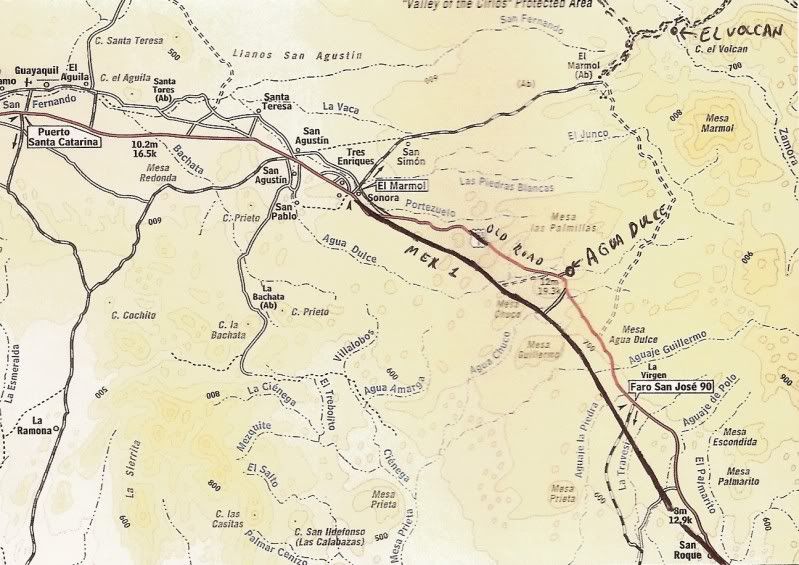
Okay... I just made some marks on this one to show the location of Agua Dulce and El Volcan... You will see that I drew in Hwy. 1 in its more true
location... the 2003 Baja Almanac had simply 'paved over' the old main road beyond Rancho Sonora. The 2009 Almanac corrected that error.
|
|
|
Curt63
Super Nomad
Posts: 1171
Registered: 3-28-2009
Location: San Diego, Ca.
Member Is Offline
Mood: Fish tacos and Tecate
|
|
Great Stuff!
No worries
|
|
|
BajaBlanca
Select Nomad
Posts: 13165
Registered: 10-28-2008
Location: La Bocana, BCS
Member Is Offline
|
|
definite yes on maps. great that you are doing this BTW.
|
|
|
David K
Honored Nomad
Posts: 64507
Registered: 8-30-2002
Location: San Diego County
Member Is Offline
Mood: Have Baja Fever
|
|
Okay... thanks for that! I will make maps pointing out the other places or roads I have published logs of, above... Maybe this week... unless I get
more work (please)... I had a job today, gracias a Dios!
[Edited on 12-8-2010 by David K]
|
|
|
David K
Honored Nomad
Posts: 64507
Registered: 8-30-2002
Location: San Diego County
Member Is Offline
Mood: Have Baja Fever
|
|
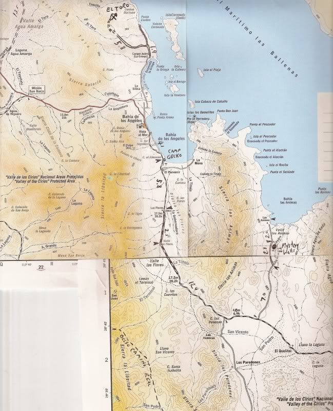
L.A. Bay area
Okay, the next map covers the road to Bahia Las Animas, as well as the El Toro Copper Mine, north of La Gringa.
3 map pages had to be spliced to make this on one page... and the southern map scale does not match with the two northern maps, so it is slid to the
east to align the Las Animas road and the road south of Las Flores (which was shown in the wrong place already) was redrawn in.
The fork at the mileage dart 2.5 miles south of Las Flores is the old road that continues ahead to the San Juan Mine Tram/ Railroad Terminal... where
ore was transfered from the cable buckets to the railroad cars to go north (5.5 miles) to Las Flores for processing into ingots.
Because the maps don't align, I didn't add those details onto it. The terminal platform is about 3 miles south from the graded road. It is one of the
most interesting historic sites around L.A. Bay. The San Juan mines are on top of the mountain... Great viewing on Google Earth.
|
|
|
David K
Honored Nomad
Posts: 64507
Registered: 8-30-2002
Location: San Diego County
Member Is Offline
Mood: Have Baja Fever
|
|
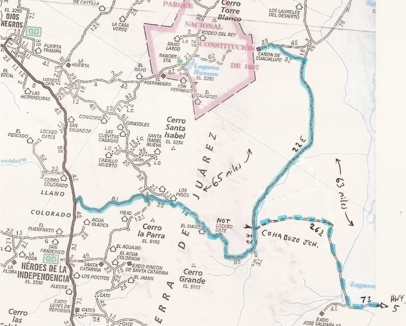
Mano Canyon (Hwy. 3 to Guadalupe Canyon)
Both routes shown are suitable only for 4WD vehicles with low range and 9"+ of ground clearance between Cohabuzo Jcn. and Los Pinos, or east to Laguna
Salada.
Here is the approx. route we took in 2003 from Hwy. 3 near Agua Blanca to Guadalupe Canyon, via Mano Canyon, highlighted.
Also, the route to Hwy. 5 via Cohabuzo Jcn. is shown.. dashed highlighting (traveled in 2002):
|
|
|
BajaWarrior
Super Nomad
Posts: 2307
Registered: 9-27-2006
Location: Mission Bay, San Diego. Playa Hermosa, San Felipe.
Member Is Offline
Mood: Anxious to get south
|
|
| Quote: | Originally posted by David K
Okay... thanks for that! I will make maps pointing out the other places or roads I have published logs of, above... Maybe this week... unless I get
more work (please)... I had a job today, gacias a Dios! |
Sweet revenge! You misspelled a word, gacias! Hah!
BW
Haven't had a bad trip yet....
|
|
|
BajaWarrior
Super Nomad
Posts: 2307
Registered: 9-27-2006
Location: Mission Bay, San Diego. Playa Hermosa, San Felipe.
Member Is Offline
Mood: Anxious to get south
|
|
| Quote: | Originally posted by David K
| Quote: | Originally posted by BajaWarrior
| Quote: | Originally posted by David K
Okay... thanks for that! I will make maps pointing out the other places or roads I have published logs of, above... Maybe this week... unless I get
more work (please)... I had a job today, gacias a Dios! |
Sweet revenge! You misspelled a word, gacias! Hah!
BW |
Hi Chuck...
A letter was missing... that sir, I would call a typo. I know the word is gracias. However, I am not a spell checker on words, just GEOGRAPHIC PLACES
in Baja.
When somebody types Guerro or Mallarimo or Puertocitos or Alphonsina's or Los Barilles... those aren't typos... just honest errors that I think, as
guests in Mexico, it would be nice to spell their places right (even if they don't, lol)!
I hope we see you over New Years! (PS I need work, please)
|
Hey man, whatever you want to believe! LOL
See you in Santa Maria/Playa Hermosa for New Years!
Chuck
Oh and, Thanks for the trip notes, very valuable informatation.
[Edited on 12-8-2010 by BajaWarrior]
Haven't had a bad trip yet....
|
|
|
David K
Honored Nomad
Posts: 64507
Registered: 8-30-2002
Location: San Diego County
Member Is Offline
Mood: Have Baja Fever
|
|
No problemo my friend... Hasta Pronto!
|
|
|
shari
Select Nomad
Posts: 13033
Registered: 3-10-2006
Location: bahia asuncion, baja sur
Member Is Offline
Mood: there is no reality except the one contained within us "Herman Hesse"
|
|
ummm....that's no prolemA.....david...oh geez, now ya got ME doing it!
as I always tell my student...problems are femine!!! hahahaha
|
|
|
David K
Honored Nomad
Posts: 64507
Registered: 8-30-2002
Location: San Diego County
Member Is Offline
Mood: Have Baja Fever
|
|
If it isn't on a map, I can't spell it correctly! 
That's the way I heard Arnold say it in Terminator 2! 
|
|
|
salttram
Junior Nomad
Posts: 50
Registered: 9-17-2003
Member Is Offline
|
|
. . . and I thought it was so fun getting lost . . .
|
|
|
David K
Honored Nomad
Posts: 64507
Registered: 8-30-2002
Location: San Diego County
Member Is Offline
Mood: Have Baja Fever
|
|
| Quote: | Originally posted by salttram
. . . and I thought it was so fun getting lost . . . |
That would be a good name for my book... 'Getting Lost in Baja, On Purpose!'
What keeps it interesting is there are new roads and new detours all the time... Even the highway kilometer markers get moved, to keep it interesting.
My guide will have side roads located by kilometer markers, mileage from the last town (Pemex station) and GPS... One of them should get you started
in the right place!
Once you are on the side road... you may be on your own if conditions change?
[Edited on 12-21-2010 by David K]
|
|
|
| Pages:
1
2 |
|


