| Pages:
1
2
3 |
David K
Honored Nomad

Posts: 64493
Registered: 8-30-2002
Location: San Diego County
Member Is Offline
Mood: Have Baja Fever
|
|
Baja's Mission Visitas
A 'vista' or 'estancia' was a satellite visiting station of a mission. Generally the padre visited it monthly to perform services, check on the local
rancheria (settlement of natives) and so forth. Most missions had several visitas and often a vista would be the next mission in the chain.
Here are some photos of visitas (with the mission named it belonged to) from http://vivabaja.com/bajamissions
SAN JUAN BAUTISTA LONDO (Loreto)

----------------------------------------------------------------------
LA PRESENTACION (San Javier)

------------------------------------------------------------------------
SAN JOSE DE MAGDALENA (Mulege)

--------------------------------------------------------------------------
SAN JACINTO (Todos Santos)

---------------------------------------------------------------------------
SAN PABLO (Santa Gertrudis)

---------------------------------------------------------------------------
CALAMAJUE (San Borja) Also, it was the site for Mision Santa Maria for a few months.

---------------------------------------------------------------------------
SAN JUAN DE DIOS (San Fernando)

[Edited on 1-9-2008 by David K]
|
|
|
David K
Honored Nomad
Posts: 64493
Registered: 8-30-2002
Location: San Diego County
Member Is Offline
Mood: Have Baja Fever
|
|
San Juan de Dios (as seen above) was reported plowed over, destroyed by a farmer or ejido... by John M and Neal Johns... Neither had been there before
but used my GPS waypoint and directions to see the site.
On the small chance they were in the wrong spot, I hope to return and see for myself and take photos of what is truely a crime against history!
The site had been recognized by INAH and they did make a plan of the building layout... However, the site location was not published, marked, signed
or fenced off... it was kept a 'secret', hidden by some brush from the road... Perhaps the ejido tractor driver didn't know, or did... but nobody else
knew it was there, so it wouldn't be missed... and he can make more growing chiles on the land???
|
|
|
BAJACAT
Ultra Nomad
Posts: 2902
Registered: 11-21-2005
Location: NATIONAL CITY, CA
Member Is Offline
|
|
What about SANTA ANA for Mision San Borja..
BAJA IS WHAT YOU WANTED TO BE, FUN,DANGEROUS,INCREDIBLE, REMOTE, EXOTIC..JUST GO AND HAVE FUN.....
|
|
|
Mango
Senior Nomad
Posts: 685
Registered: 4-11-2006
Location: Alta California &/or Mexicali
Member Is Offline
Mood: Bajatastic
|
|
Interesting David. I think I may have spotted La Presentacion (San Javier) on the side of the road between San Javier and san Jose de Comondu
recently.

My image was taken from the road. I think yours may be from the other side. If not.. do you know what it is?.. it was on the NE side of the road
near a little rancho by a shallow wash. I'll have to look in my Baja Almanac to find where it was for sure.
|
|
|
David K
Honored Nomad
Posts: 64493
Registered: 8-30-2002
Location: San Diego County
Member Is Offline
Mood: Have Baja Fever
|
|
| Quote: | Originally posted by BAJACAT
What about SANTA ANA for Mision San Borja.. |
I did go to Santa Ana in July, 2003 from Mision San Borja (a very tough, seldom used road) then on to San Ignacito where another San Borja visita was
located.
I did not see any ruins at Santa Ana, but the graves are next to the road... the oasis is just south...

Here is the caption under that photo , in my 703 web page:
The site of a mission visiting station, today Santa Ana is abandoned.
A large oasis is in the back ground.
This small graveyard is next to the seldom traveled road at 28°41.47'/ 113°41.35'.
Two large graves next to this one can be seen at: www.bajataco.com/Baja/Padres-at-Rest.html
Here is bajataco's photo of the two large graves next to the one I photographed:

At Rancho San Ignacito are these adobe ruins and might be the remains of the San Borja vista of 'San Ignacio':

Caption reads: Adobe ruins at Rancho San Ignacito.
The oasis here was also the site of a San Borja visita (then called San Ignacio).
GPS: 28°44.34'/ 113°50.62' (NAD27).
Because I am not sure that was indeed the ruins of the visita, I did not include it in the group of vista photos.
|
|
|
David K
Honored Nomad
Posts: 64493
Registered: 8-30-2002
Location: San Diego County
Member Is Offline
Mood: Have Baja Fever
|
|
| Quote: | Originally posted by Mango
Interesting David. I think I may have spotted La Presentacion (San Javier) on the side of the road between San Javier and san Jose de Comondu
recently.
My image was taken from the road. I think yours may be from the other side. If not.. do you know what it is?.. it was on the NE side of the road
near a little rancho by a shallow wash. I'll have to look in my Baja Almanac to find where it was for sure. |
Nope, La Presentacion is south of San Javier on the road to Santo Domingo/ Insurgentes... But a great photo of some ruins! There is an old 'horno'
used to make adobe or tiles along the road to Comondu from San Javier.
Here is the photo again:
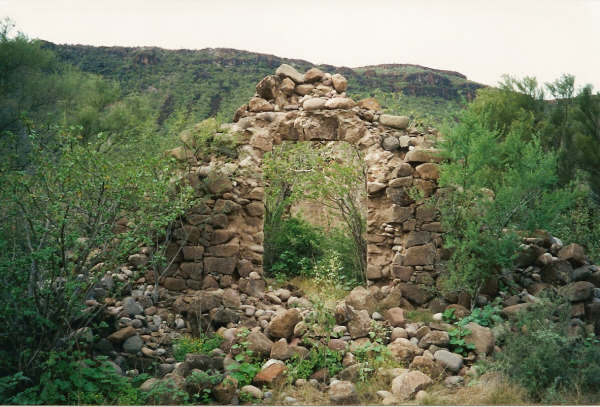
and the caption that is on the Baja missions web page with that photo: This chapel/ visita was probably built by the Franciscan Fr. Palou in 1769.
Located 11 miles south of San Javier. Photo by Kevin Clough, 1-98.
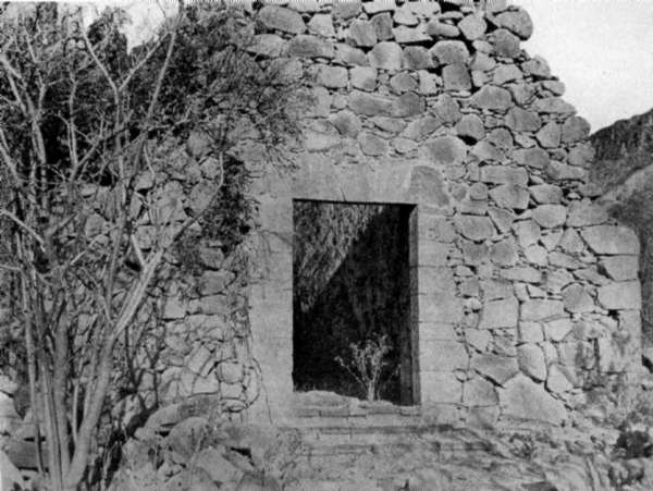
La Presentacion about 1905... (the door way has recently collapsed, it was reported):
[Edited on 1-23-2014 by David K]
|
|
|
Mango
Senior Nomad
Posts: 685
Registered: 4-11-2006
Location: Alta California &/or Mexicali
Member Is Offline
Mood: Bajatastic
|
|
Thanks for the info David. I looked on Google Earth and think I found the structure I took a photo of:
It was rather round.. almost like a tower of some sort. It could have been an oven of sorts. Not far from San Jose de Comondu. Baja Almanac has it
right around a place named El Horno. So an oven would make sense.
I am almost positive the location is: (did not put a waypoint in my GPS ..Doh!)
25°59'46.61"N
111°42'37.19"W
http://maps.google.com/maps?hl=en&ie=UTF8&ll=25.996369,-111.
|
|
|
David K
Honored Nomad
Posts: 64493
Registered: 8-30-2002
Location: San Diego County
Member Is Offline
Mood: Have Baja Fever
|
|
| Quote: | Originally posted by Mango
Thanks for the info David. I looked on Google Earth and think I found the structure I took a photo of:
It was rather round.. almost like a tower of some sort. It could have been an oven of sorts. Not far from San Jose de Comondu. Baja Almanac has it
right around a place named El Horno. So an oven would make sense.
I am almost positive the location is: (did not put a waypoint in my GPS ..Doh!)
25°59'46.61"N
111°42'37.19"W
http://maps.google.com/maps?hl=en&ie=UTF8&ll=25.996369,-111. |
Your link ended (too long?) after the 111. ? What is te rest of the longitude #?
Thanks!
|
|
|
David K
Honored Nomad
Posts: 64493
Registered: 8-30-2002
Location: San Diego County
Member Is Offline
Mood: Have Baja Fever
|
|
See El Horno and the ruins of 'Santa Rosalia' chappel mentioned in my post on the El Camino Real, in that area. I wonder if you photographed that
ruin... or is the giant horno ruined... I will dig up a photo of it:
EL CAMINO REAL in Baja (Part 2), Loreto to Comondu
Baja Almanac Page 42:
From the first California mission of LORETO to the second, Mision San Francisco Javier, the mission trail utilized the canyon of LAS PARRAS to the
first site of Mision San Javier which today is called RANCHO VIEJO. The modern auto road is built in the same canyon.
One tenth of a mile west of RANCHO VIEJO the Camino Real splits. To the left (south) goes the trail to SAN JAVIER (5.5 mi.). To the right (west) the
Camino Real heads for Comondu and beyond.
On the Camino Real, 1.0 mi. from RANCHO VIEJO the old trail is joined by the Comondu auto road coming from the Loreto-San Javier road (junction at 1.0
mi. past Rancho Viejo).
2.2 mi. from Rancho Viejo another trail joins in from the south. This was the direct Camino Real from San Javier to Comondu, branching from the
Loreto-San Javier trail at EL HORNO (Los Hornoso in the Almanac). This small triangle of trails shows the Jesuits built many roads to offer direct
routes, much like modern highways.
4.0 miles from Rancho Viejo, the Camino Real turns left from the Comondu auto road and follows ARROYO SANTA ISABEL.
Baja Almanac Page 41:
EL PALMARITO is just south of the Camino Real which goes to a visita (visiting station) of San Javier known as Santa Rosalia (renamed Santa
Roasalillita). A stone chapel ruin remained in 1955. Santa Rosalillita is not shown in the Almanac, but the Camino Real is. The old trail goes
westerly for about 5 miles from the edge of the map (just above El Palmarito), then turns almost to the north and goes to QUINI.
The original Camino Real continued north from Quini to San Miguel Comondu (reaches top of Almanac page 41 at letter O, crosses the extreme lower left
corner of Almanac page 40, and reaches SAN MIGUEL COMONDU, on map page 39.
When the newer mission of SAN JOSE COMONDU was moved to just north of San Miguel, the Camino Real was re-alligned at Quini to go more directly to San
Jose Comondu passing between CERRO CAPI and CERRO COLORADO, on Almanac page 40.
|
|
|
XRPhlang
Nomad
Posts: 111
Registered: 10-12-2007
Location: Central Coast
Member Is Offline
Mood: Taco me.
|
|
The original site of La Primisma as showed to me by the old rancher that lives next to the site.
|
|
|
XRPhlang
Nomad
Posts: 111
Registered: 10-12-2007
Location: Central Coast
Member Is Offline
Mood: Taco me.
|
|
uh oh, I tried to attach the photo, but it didn't work. Can anyone help?
|
|
|
David K
Honored Nomad
Posts: 64493
Registered: 8-30-2002
Location: San Diego County
Member Is Offline
Mood: Have Baja Fever
|
|
Just email me the photo and I will size it to Nomad specs and post it here for you... Jack Swords took photos at Purisima Vieja, but they only showed
very little... so I never added it to the missions page. My email is info*at*vivabaja.com and put Baja in the subject line.
Here is the mention of it under the La Purisima photo:
The original site now called Purisima Vieja is at N 26°18.59' W 112°09.70' . (Waypoints on the mission page are at WGS84).
Here is a photo from Jack at the first Purisima mission location, where he found only a stone foundation:
[Edited on 1-11-2008 by David K]

|
|
|
David K
Honored Nomad
Posts: 64493
Registered: 8-30-2002
Location: San Diego County
Member Is Offline
Mood: Have Baja Fever
|
|
Another angle on that stone foundation at Purisima Vieja, from Jack Swords, 2002:

|
|
|
David K
Honored Nomad
Posts: 64493
Registered: 8-30-2002
Location: San Diego County
Member Is Offline
Mood: Have Baja Fever
|
|
The area of Purisima Vieja from Jack Swords, 2002:

|
|
|
David K
Honored Nomad
Posts: 64493
Registered: 8-30-2002
Location: San Diego County
Member Is Offline
Mood: Have Baja Fever
|
|
XRPhlang #1 0f 2 (Purisima Vieja)
| Quote: | Originally posted by XRPhlang
uh oh, I tried to attach the photo, but it didn't work. Can anyone help? |

|
|
|
David K
Honored Nomad
Posts: 64493
Registered: 8-30-2002
Location: San Diego County
Member Is Offline
Mood: Have Baja Fever
|
|
#2 of 2

|
|
|
Mango
Senior Nomad
Posts: 685
Registered: 4-11-2006
Location: Alta California &/or Mexicali
Member Is Offline
Mood: Bajatastic
|
|
| Quote: | Originally posted by David K
Your link ended (too long?) after the 111. ? What is te rest of the longitude #?
Thanks! |
Ok David, try this link.. It should work. There was a little rancho just SE of the round structure. Also, I noticed a foundation(?) just across the
road from the round structure on the satellite photo.
link
|
|
|
Sharksbaja
Elite Nomad
Posts: 5814
Registered: 9-7-2004
Location: Newport, Mulege B.C.S.
Member Is Offline
|
|
So very cool, gracias David. I wonder how many of these are still undiscovered. I see you got the credit you deserved. Tommy Afrika was a busy
guy
Here is a list I have from Google Earth:
List of Missions ... Mexico & California
Refs.: Wikipedia / Baja ... Wikipedia / California
MEXICO: Baja California Norté & Baja California Sur
Jesuit Establishments (1683-1767)
Misión San Bruno (1683-1685)
(1) Misión Nuestra Senora de Loreto Conchó (1697-1829)
(2) Misión San Francisco Javier Vigge Biaundó (1699-1817)
Visita de San Juan Bautista Londó (1699-1745)
(3) Misión San Juan Bautista Malbat (Liguí) (1705-1721)
(4) Misión Santa Rosalia de Mulegé (1705-1828)
(5) Misión San Jose de Comondú (1708-1827)
(6) Misión La Purisima Concepción de Cadegomó (1720-1822)
(7) Misión de Nuestra Señora del Pilar de La Paz Airapí (1720-1749)
(8) Misión Nuestra Senora de Guadalupe de Huasinapi (1720-1795)
(9) Misión Santiago de Los Coras (1721-1795)
(10) Misión Nuestra Senora de los Dolores del Sur Chillá (1721-1768)
(11) Misión San Ignacio Kadakaamán (1728-1840)
(12) Misión Estero de las Palmas de San José del Cabo Añuití (1730-1840)
(13) Misión Santa Rosa de las Palmas (Todos Santos) (1733-1840)
(14) Misión San Luis Gonzaga Chiriyaqui (1740-1768)
(15) Misión Santa Gertrudis (1752-1822)
(16) Misión San Francisco Borja (1762-1818)
Visita de Calamajué (1766-1767)
(17) Misión Santa María de los Angeles (1767-1768)
Visita de la Presentación (1769-1817)
Franciscan Establishments (1768-1773)
(1) Misión San Fernando Rey de España de Velicatá (1769-1772)
Established by Father Junipero Sierra in and taken over by the Dominicans, this is the only Franciscan mission built in Baja.
Dominican Establishments (1774-1849)
Misión San Fernando Rey de España de Velicatá (1772-1818)
Established by Father Junipero Sierra in and taken over by the Dominicans, this is the only Franciscan mission built in Baja.
(1) Misión Nuestra Señora del Santísimo Rosario de Viñacado (1774-1832)
Visita de San José de Magdalena (1774-1828)
(2) Misión Santo Domingo de la Frontera (1775-1839)
(3) Misión San Vicente Ferrer (1780-1833)
(4) Misión San Miguel Arcangel de la Frontera (1797-1834)
(5) Misión Santo Tomás de Aquino (1791-1849)
(6) Misión San Pedro Mártir de Verona (1794-1824)
(7) Misión Santa Catarina Vírgen y Mártir (1797-1840)
Visita de San Telmo (1798-1839)
(8) Misión El Descanso (San Miguel la Nueva) (1817-1834)
(9) Misión Nuestra Senora de Guadelupe del Norte (1834-1840)
David does this jive with your info.
DON\'T SQUINT! Give yer eyes a break!
Try holding down [control] key and toggle the [+ and -] keys
Viva Mulege!
Nomads\' Sunsets
|
|
|
Jack Swords
Super Nomad
Posts: 1094
Registered: 8-30-2002
Location: Nipomo, CA/La Paz, BCS
Member Is Offline
|
|
Here is Fred's photo of the horno. When I saw it it had the sign too. Looks like someone took the sign. Part of the cement making process for the
missions. Well located between Comondu and San Javier.
http://math.ucr.edu/ftm/bajaPages/BajaRoadPages/Route1/image...
|
|
|
Cypress
Elite Nomad
Posts: 7641
Registered: 3-12-2006
Location: on the bayou
Member Is Offline
Mood: undecided
|
|
Near Mulege is an old graveyard surrounded by a low stone wall about 40'x40'. 
|
|
|
| Pages:
1
2
3 |


