| Pages:
1
2 |
Geothermal-Shane
Junior Nomad

Posts: 83
Registered: 5-14-2005
Member Is Offline
|
|
Northern Baja Sierras: WATER
To anybody experienced in this region:
Based on a reported annual precipitation of 24 inches(?) about what time in the spring or summer would one expect the watersheds of the San Pedro
Martir Plateau to begin drying up?
My plans include a possible loop trip, maybe early April, from Vallecitos to La Tasajera, La Grulla, La Encantada, Los Llanitos, Cerro La Botella
Azul/Scout Peak and back to Vallecitos. Maybe for or five days?
[Edited on 2-10-2008 by Geothermal-Shane]
|
|
|
Mexitron
Ultra Nomad
Posts: 3397
Registered: 9-21-2003
Location: Fort Worth, Texas
Member Is Offline
Mood: Happy!
|
|
Mainly depends on the year and how late the rains come...really hard to gauge it as any one time when it dries out--even summers can be wet up there.
Best thing is keep an eye on the weather and proceed accordingly. The other thing to know is where there is water all year round(ie--springs) so
you're not guessing. The major rivers coming from the mountains--San Rafael, etc. ususally have water somewhere along their length but it may not be
near the top of the tablelands in dry years...where are you thinking of going?
|
|
|
mtgoat666
Select Nomad
Posts: 17289
Registered: 9-16-2006
Location: San Diego
Member Is Offline
Mood: Hot n spicy
|
|
| Quote: | Originally posted by Geothermal-Shane
To anybody experienced in this region:
Based on a reported annual precipitation of 24 inches(?) about what time in the spring or summer would one expect the watersheds of the San Pedro
Martir Plateau to begin drying up? |
depends on where you are interested in...
if you are looking for water for camping or backpacking on the plateau or in canyons, many deep canyons in SPM have springs or creeks that run year
round. august or so is t-storm season and some of the dry creeks flow periodically in summer, but best to rely on springs in canyons. for car
camping on the plateau, you can almost always find water in the deep canyon S-SW of the observatory.
|
|
|
Barry A.
Select Nomad
Posts: 10007
Registered: 11-30-2003
Location: Redding, Northern CA
Member Is Offline
Mood: optimistic
|
|
Back in the 60's and 70's there were streams on the plateau that had trout in them, which means that they ran all year round. I was up there, and I
personally saw the trout.
Has that changed?
barry
|
|
|
tajo
Junior Nomad
Posts: 37
Registered: 9-12-2005
Location: San Diego, CA
Member Is Offline
|
|
| Quote: | Originally posted by Geothermal-Shane
To anybody experienced in this region:
My plans include a possible loop trip, maybe early April, from Vallecitos to La Tasajera, La Grulla, La Encantada, Los Llanitos, Cerro La Botella
Azul/Scout Peak and back to Vallecitos. Maybe for or five days?
[Edited on 2-10-2008 by Geothermal-Shane] |
Hi, maybe I will try to go there in April as well, but rather around 9th. I know Scout Peak and Botella Azul, but everything behind Entacada is very
interesting to me , including any easy descend to Valle Chico - what do you know about it - what canyon is the best - Agua Caliente or any other
closer to Picacho ?
|
|
|
DENNIS
Platinum Nomad
Posts: 29510
Registered: 9-2-2006
Location: Punta Banda
Member Is Offline
|
|
I would guess, since nobody here has a definitive answer, that they would dry up at near the same time as those in the San Bernadino Mountains.
When do they dry up?
|
|
|
David K
Honored Nomad
Posts: 64478
Registered: 8-30-2002
Location: San Diego County
Member Is Offline
Mood: Have Baja Fever
|
|
| Quote: | Originally posted by Geothermal-Shane
To anybody experienced in this region:
Based on a reported annual precipitation of 24 inches(?) about what time in the spring or summer would one expect the watersheds of the San Pedro
Martir Plateau to begin drying up?
My plans include a possible loop trip, maybe early April, from Vallecitos to La Tasajera, La Grulla, La Encantada, Los Llanitos, Cerro La Botella
Azul/Scout Peak and back to Vallecitos. Maybe for or five days?
[Edited on 2-10-2008 by Geothermal-Shane] |
Several water sources up there are year-round... as Barry mentioned trout do live in more than one stream... the San Rafael being the most well known,
with San Antonio the next (above the falls).
I recomend Graham Mackintosh's third book, as his time up there and research is really a great read! http://www.grahammackintosh.com

[Edited on 2-10-2008 by David K]
|
|
|
Barry A.
Select Nomad
Posts: 10007
Registered: 11-30-2003
Location: Redding, Northern CA
Member Is Offline
Mood: optimistic
|
|
| Quote: | Originally posted by tajo
| Quote: | Originally posted by Geothermal-Shane
To anybody experienced in this region:
My plans include a possible loop trip, maybe early April, from Vallecitos to La Tasajera, La Grulla, La Encantada, Los Llanitos, Cerro La Botella
Azul/Scout Peak and back to Vallecitos. Maybe for or five days?
[Edited on 2-10-2008 by Geothermal-Shane] |
Hi, maybe I will try to go there in April as well, but rather around 9th. I know Scout Peak and Botella Azul, but everything behind Entacada is very
interesting to me , including any easy descend to Valle Chico - what do you know about it - what canyon is the best - Agua Caliente or any other
closer to Picacho ? |
The late Edward "Bud" Bernhard of Coronado, CA who pioneered several routes to the top of Picacho del Diablo back in the 50's and beyond, hiked
historic "trails" from the bottom of the escarpment up Canada Agua Caliente, as well as Canada El Cajon, all the way west to the site of Mission San
Pedro Martir on several occasions. He also hiked the trail from La Grulla south to the Mission site several times. That was a long time ago, but it
certainly should be feasible today as well.
barry
|
|
|
bajalou
Ultra Nomad
Posts: 4459
Registered: 3-11-2004
Location: South of the broder
Member Is Offline
|
|
Local Mexican friends have told me that the trail in Canon Cajon that had been used for many years was washed out and away by Hurricane Nora in 97.
He said it is now impossible to traverse the canyon without some serious mountain climbing equipment and skills.
No Bad Days
\"Never argue with an idiot. People watching may not be able to tell the difference\"
\"The trouble with doing nothing is - how do I know when I\'m done?\"
Nomad Baja Interactive map
And in the San Felipe area - check out Valle Chico area |
|
|
Barry A.
Select Nomad
Posts: 10007
Registered: 11-30-2003
Location: Redding, Northern CA
Member Is Offline
Mood: optimistic
|
|
| Quote: | Originally posted by bajalou
Local Mexican friends have told me that the trail in Canon Cajon that had been used for many years was washed out and away by Hurricane Nora in 97.
He said it is now impossible to traverse the canyon without some serious mountain climbing equipment and skills. |
Lou----sounds like a "challenge" to me. 
|
|
|
David K
Honored Nomad
Posts: 64478
Registered: 8-30-2002
Location: San Diego County
Member Is Offline
Mood: Have Baja Fever
|
|
Anyone know where Burro Bob is? He lives at the mouth of Cajon Canyon and would know the trail condition...
|
|
|
mtgoat666
Select Nomad
Posts: 17289
Registered: 9-16-2006
Location: San Diego
Member Is Offline
Mood: Hot n spicy
|
|
| Quote: | Originally posted by tajo
| Quote: | Originally posted by Geothermal-Shane
To anybody experienced in this region:
My plans include a possible loop trip, maybe early April, from Vallecitos to La Tasajera, La Grulla, La Encantada, Los Llanitos, Cerro La Botella
Azul/Scout Peak and back to Vallecitos. Maybe for or five days?
[Edited on 2-10-2008 by Geothermal-Shane] |
Hi, maybe I will try to go there in April as well, but rather around 9th. I know Scout Peak and Botella Azul, but everything behind Entacada is very
interesting to me , including any easy descend to Valle Chico - what do you know about it - what canyon is the best - Agua Caliente or any other
closer to Picacho ? |
Diablo Canyon is hiked frequently and is easy. All of the canyons are doable, if you like bushwacking and are prepared to do some rock climbing or
rappeling. Jerry Schad's map of SPM park has good trail map and some basic route descriptions for a number of canyons. Wherever you go, be prepared
to bushwhack, and bring a map/compass, as route finding on the plateau is challenging.
When I was there in mid April, the nights were very cold (water bottles froze every nite), and we found lots of snow patches in shady areas,... if you
wait 'til May, the vegetation will be prettier and much will be growing/in bloom.
If you want to do a loop thru the meadows/plateau south of the observatory road, I suggest taking mtn bikes and using the ranchers access roads to get
around.
|
|
|
baron
Junior Nomad
Posts: 76
Registered: 1-29-2008
Member Is Offline
|
|
Any good maps???
That sounds good ...a loop? We are hoping to take our dual sport bikes on a trip. What are the best maps of the N Baja area you refer to?
|
|
|
wilderone
Ultra Nomad
Posts: 3778
Registered: 2-9-2004
Member Is Offline
|
|
Take gaitors - lots of snakes.
|
|
|
tajo
Junior Nomad
Posts: 37
Registered: 9-12-2005
Location: San Diego, CA
Member Is Offline
|
|
Hi David, Barry, BajaLou and Mtgoat666,
thank you for the good advise, which now i am trying to summarize:
1. The Diablo Canyon and other canyons around Picacho del Diablo (Diablo, Diablito, Providencia ) are on the Jerry Schad's map of SPM park, and I
have descriptions of these routes, but mostly some climbing equipment, like a rope is necessary ( maybe except the Canyon del Diablo where is a fixed
iron rope in the most difficult place ). But this time I am not asking about the Diablo Canyon approach.
2. There are historical routes in Canada Agua Calente and Canada El Cajon canyons, but Cajon is destroyed, and Burro Bob may know the Cajon route.
I must read more carefully " Land of Chamise and Pines "
http://books.google.com/books/ucpress?vid=ISBN9780520098251
about early exploration of El Cajon Canyon and check if it is the same canyon, we are talking about.
In the page 68 there are such names as Longinos-Martinez (1792), Colonel D.K.Allen (1888), Wiggins(1944)
and an interesting footnote :" Longinos Martinez was spooked by the mountains , thus inspiring the place name La Encantada (bewitched)"
3 It is good to check the books about Edward "Bud" Bernhard
like "COMING HOME FROM DEVIL MOUNTAIN" by Eleanor Dart O'Bryon, published by Harbinger House.
Do you know the authors of the following on-line photo-albums:
Sierra San Pedro Martir - Dedicated to Bud Bernhard
Canyon Medio and Toledo
http://sanpedromartir.com/photos/displayimage.php?album=11&a...
La Grulla to the Mission
http://sanpedromartir.com/photos/thumbnails.php?album=10
4 Mexitron wrote about the Nordhoff family and vaqueros on La Grulla. Do you know their reports, and did they descend from La Encantada to Valle
Chico ?
5 An approach from El Parral through Matomi Canyon to Matomi Peak is described in:
http://angeles.sierraclub.org/dps/archives/dps02173.htm
They mentioned Tres Palomas, and Cerro Venado Blanco as interesting peaks visible from Matomi . Another source mentions Tres Venados.
Does anybody know these peaks, except the popular Matomi ?
[Edited on 2008-2-11 by tajo]
|
|
|
mtgoat666
Select Nomad
Posts: 17289
Registered: 9-16-2006
Location: San Diego
Member Is Offline
Mood: Hot n spicy
|
|
tajo,
Cerro venado blanco and other peaks you ask about are on Jerry Schads map and in Robinson's book. I climbed Cerro venado blanco last year, and just
navigated with Schad's map -- round trip is an overnite hike at slow-moderate pace, or a long day if you travel light and jog/walk (15 miles round
trip? and leave a few extra hours for getting lost once or twice along the way)
Looks like you found most of the references. A map and a few old trip reports is about all you will find. the canyons you are asking about are so
little traveled that i doubt you will find much in the way of clear trails. The great thing about SPM is there is not much published, and the severe
topography and distances and lack of facilities deter the couch potatoes -- which keeps out all of the idle curious, and leaves the area to be enjoyed
by each new explorer. if you find any info, please don't post anything but vague hints, which leaves the area to be discovered anew by the next
person explorer. publication of detailed route info and clearing of trails will bring too many people, ruining it for everyone.
|
|
|
David K
Honored Nomad
Posts: 64478
Registered: 8-30-2002
Location: San Diego County
Member Is Offline
Mood: Have Baja Fever
|
|
More links
Tajo has some really good info!
On my web site list of links are a couple more of interest:
Climbing Diablo (incl. maps)
Climbing Matomi, Mesa el Avion & up Matomi canyon (Mexitron)
The area of the southern San Pedro Martir is quite interesting with its many blue palm canyons, year round running water, lack of roads and reported
trails that cross over the peninsula!
|
|
|
tajo
Junior Nomad
Posts: 37
Registered: 9-12-2005
Location: San Diego, CA
Member Is Offline
|
|
Lack of reported trails ?
I do not agree - there is many reports, starting from 1792 - but there is a recent policy of San Diegan and Baja climbers not to publish any
guide-books in print or on-line. I partly agree, because some areas with an easy approach like El Trono Blanco in Sierra Juarez and the Cliffs of
Picacho may be endangered by climbing crowd like it happened in the Joshua Tree, when it obtained National Park status and fame, but it is rather
impossible on the southern side of Parque San Pedro Martir - unless the Parque officials allow cars to enter La Grulla ( i hope they won't) . I have
mixed feelings about a possible touristic development of the Palm Canyons above Laguna Salada - I wrote already about other dangers, which are more
serious than hiking trails.
Anyway thanks to Mtgoat666 for the info about Cerro Venado Blanco - but i don't see it on the Schad's map - maybe because I have only a southern
half of the map, and it is north.
I found the next Sierra Report about the Middle Palomas Peak, where the authors write:
| Quote: | Originally posted by http://angeles.sierraclub.org/dps/archives/dps00239.htm
Of course, South Summit Picacho Del Diablo still awaits us, as does Cerro Venado Blanco (a 9200 ft peak north of the Observatorio road) and a "Dual
Canyon" trip (up Canyon Agua Caliente, across the Sierra San Pedro Martir Plateau from Santa Eulalia to Santa Rosa meadow, then back down to the
desert via Canyon El Cajon). And Ron Jones has initiated a case of ."Matomi canyon and peak "fever", which hopefully I can "cure" at some point in the
future with a trip to that region. So many mountains. So little time. |
[Edited on 2008-2-12 by tajo]
|
|
|
Mexitron
Ultra Nomad
Posts: 3397
Registered: 9-21-2003
Location: Fort Worth, Texas
Member Is Offline
Mood: Happy!
|
|
tajo--that's an intersting article on Pico Matomi by John Robinson. By the way, Barry A.--if you read the article it mentions the "Gunsight Notch" I
was talking about in reference to the Canon Guadalupe area--its actually above Parral on the way to Matomi.
I'll see if I have any of the documentation on the Nordhoff's trip to the SPM...if not I'll try to get some from Frank Nordhoff in CA.
|
|
|
Mexitron
Ultra Nomad
Posts: 3397
Registered: 9-21-2003
Location: Fort Worth, Texas
Member Is Offline
Mood: Happy!
|
|
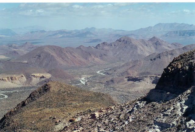
Here's the Matomi Wash Robinson was talking about; the photo is taken from the top of Mesa Avion looking over the palisades:
|
|
|
| Pages:
1
2 |


