| Pages:
1
2 |
tajo
Junior Nomad

Posts: 37
Registered: 9-12-2005
Location: San Diego, CA
Member Is Offline
|
|
Beautiful view of the Matomi Canyon !
Do you have any view from Matomi Peak in the north direction of
Tres Palomas and Picacho ?
The next report about Tres Palomas is:
http://angeles.sierraclub.org/dps/archives/dps02520.htm
and in between there must be saddles leading to El Cajon and Agua Caliente.
[Edited on 2008-2-12 by tajo]
|
|
|
mtgoat666
Select Nomad
Posts: 17295
Registered: 9-16-2006
Location: San Diego
Member Is Offline
Mood: Hot n spicy
|
|
| Quote: | Originally posted by tajo
Anyway thanks to Mtgoat666 for the info about Cerro Venado Blanco - but i don't see it on the Schad's map - maybe because I have only a southern
half of the map, and it is north.
|
t's a 2-sided map. sounds like you got a copy of only the side with zoomed view of high peaks. buy another copy if you want map of entire park,
which shows venado blanco.
|
|
|
David K
Honored Nomad
Posts: 64479
Registered: 8-30-2002
Location: San Diego County
Member Is Offline
Mood: Have Baja Fever
|
|
| Quote: | Originally posted by tajo
Beautiful view of the Matomi Canyon !
Do you have any view from Matomi Peak in the north direction of
Tres Palomas and Picacho ?
The next report about Tres Palomas is:
http://angeles.sierraclub.org/dps/archives/dps02520.htm
and in between there must be saddles leading to El Cajon and Agua Caliente.
[Edited on 2008-2-12 by tajo] |
Please take a minute and click over to Mexitron's photos, in the link above for photos from the top of Cerro Matomi ... Here it is again: http://vivabaja.com/mexitron
|
|
|
bajalou
Ultra Nomad
Posts: 4459
Registered: 3-11-2004
Location: South of the broder
Member Is Offline
|
|
Canon Cajon was called Canon Santa Rosa in some of the early 20th century maps, (Edward Nelson - Lower California and it's Natural Resources) from a
survey around 19 05-06 for the U.S. Dept. of Agriculture.
No Bad Days
\"Never argue with an idiot. People watching may not be able to tell the difference\"
\"The trouble with doing nothing is - how do I know when I\'m done?\"
Nomad Baja Interactive map
And in the San Felipe area - check out Valle Chico area |
|
|
Barry A.
Select Nomad
Posts: 10007
Registered: 11-30-2003
Location: Redding, Northern CA
Member Is Offline
Mood: optimistic
|
|
| Quote: | Originally posted by Mexitron
tajo--that's an intersting article on Pico Matomi by John Robinson. By the way, Barry A.--if you read the article it mentions the "Gunsight Notch" I
was talking about in reference to the Canon Guadalupe area--its actually above Parral on the way to Matomi.
I'll see if I have any of the documentation on the Nordhoff's trip to the SPM...if not I'll try to get some from Frank Nordhoff in CA.
|
Mexitron-----I see that reference----that clears that up!! I have tried to drive up Parral Canyon 3 different times in the past 12 years, or so, and
each time have run into a locked gate that we could not breach-----so I have never been up Parral far enough to actually see "gunsight notch". I have
driven up to the Ranch house in upper Matomi, which must be fairly close to the "notch", but we did not know what we were looking at. Thanks for
alerting me.
barry
|
|
|
Mexitron
Ultra Nomad
Posts: 3397
Registered: 9-21-2003
Location: Fort Worth, Texas
Member Is Offline
Mood: Happy!
|
|
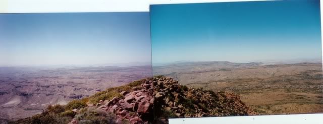
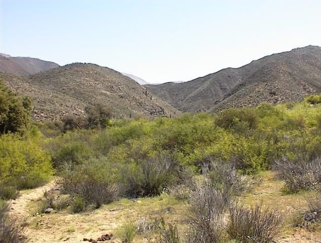
Here's the view looking north from the top of Matomi along the hogback ridge--its pretty hazy though...just to the center right I think is Cerro, eh,
forgot (begins with a "C" I think) which is midway between Matomi and Blue Bottle:
|
|
|
Geothermal-Shane
Junior Nomad
Posts: 83
Registered: 5-14-2005
Member Is Offline
|
|
Nice pictures...
Most likely we'll leave Los Angeles on April 6, and probably start hiking from Vallecitos on April 8. At this point, I think we will probably only
hike from Vallecitos to La Grulla(via La Tasajera road) and then attempt to ascend La Encantada Meadow, eventually returning the same way as opposed
to looping up through Los Llanitos...one thing at a time...I estimate that the first "SOLO" hiking sign along the La Tasajera road is about 17 miles
from La Encantada Meadow, making this a four or five day trip easily, granted there are no unfortunate mishaps.
At altitudes between 8100 and 6600 feet, the chance of snow hindering the traverse seems unlikely at that time of year, although I do not count on
anything being certain in the Sierra de San Pedro Martir...the main obstacles are water and navigation. I'm sure that five weeks from now water will
not be a problem on the plateau. As far as navigating that region, I can only base my impression on previous experience, which has proven that entire
range to be treacherous and particularly unforgiving. According to rare historical text, the high meadows of the San Pedro Martir are rich in human
history, once seasonaly inhabited by the Kiliwa people- assuring me that, at least, people have found there way through these mountains and their
massive trees and confusing rocks for thousands of years...
|
|
|
mtgoat666
Select Nomad
Posts: 17295
Registered: 9-16-2006
Location: San Diego
Member Is Offline
Mood: Hot n spicy
|
|
| Quote: | Originally posted by Geothermal-Shane
Nice pictures...
Most likely we'll leave Los Angeles on April 6, and probably start hiking from Vallecitos on April 8.
At altitudes between 8100 and 6600 feet, the chance of snow hindering the traverse seems unlikely at that time of year, |
last time I was there in early april, we had freezing nites and days in the 60s F. we also found snow patches in shady areas throughout the plateau.
freezing nites were not a problem as lots of wood for camp fires. don't rule out a snow flurry or storm in April, but low likelihood.
|
|
|
David K
Honored Nomad
Posts: 64479
Registered: 8-30-2002
Location: San Diego County
Member Is Offline
Mood: Have Baja Fever
|
|
EL PARRAL
In 2004, Gerald Jide and I explored some of the eastside San Pedro Martir canyons. http://vivabaja.com/404
We met up with Baja Lou and a dune buggy caravan from El Dorado Ranch. Also, some of the gang who backpacked to Mision San Pedro Martir with Jack
Swords (Mexitron, Taco de Baja, Pappy) was at the Parral gate Barry A mentioned, on their way to Matomi Canyon.
Barry, we were in luck, the gate was OPEN! So we drove ahead nearly 2 miles to a large corral and set up camp there. The next day, we continued on
towards Rancho El Parral for 0.6 mile to a major washout, parked and began to hike. It was 1.0 mile to the ranch (abandoned).
Some photos from my 404 web page:
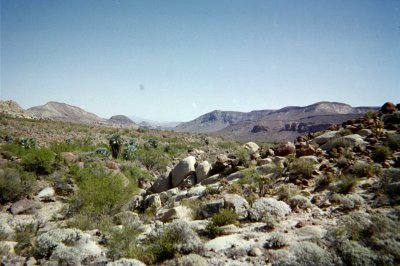
VIEW EAST towards Valle Chico

VIEW WEST towards the San Pedro Martir
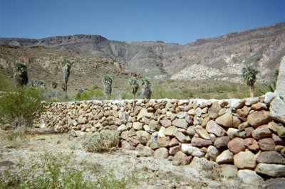
Many rock walls around the ranch

RANCHO EL PARRAL 30°29.42', 115°06.97' (NAD27)
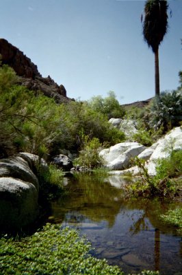
Behind the ranch
[Edited on 3-24-2008 by David K]
|
|
|
Geothermal-Shane
Junior Nomad
Posts: 83
Registered: 5-14-2005
Member Is Offline
|
|
Great pics! Really illustrates the amazing contrast of the Sierra de San Pedro Martir. The latitude of this place seems to provide a stunning
uniqeness wherein the best of the northern and southern climate zones are encompassed; coastal chaparral, pine & oak woodland, old growth mixed
coniferous forest and meadowland, alpine peaks, and sublime arid desert. Native palms thrive less than ten miles from white fir and lodgepole pines!!
Perhaps the only other place where such botanical constrasts occur is in the San Jacinto Mountains at the extreme Northern end of the peninsular
cordillera, or perhaps in the Andes Range of South America where the desert, altiplano and rainforest abound one another within only a slight
distance.
Well, that's Baja for you- the essence of strangeley distibuted wilderness...
[Edited on 3-23-2008 by Geothermal-Shane]
|
|
|
Mexitron
Ultra Nomad
Posts: 3397
Registered: 9-21-2003
Location: Fort Worth, Texas
Member Is Offline
Mood: Happy!
|
|
Geo-Shane---the curious botanical assemblages in this area has always drawn me to the SPM, especially the southern flanks where they rather abruptly
begin the transition to the central desert...here's some Cardon on the hilside in the distance with California Live Oak (var. oxydenia) in the
foreground.
|
|
|
Taco de Baja
Super Nomad
Posts: 1913
Registered: 4-14-2004
Location: Behind the Orange Curtain, CA
Member Is Offline
Mood: Dreamin' of Baja
|
|
| Quote: | Originally posted by David K
In 2004, Gerald Jide and I explored some of the eastside San Pedro Martir canyons. http://vivabaja.com/404
We met up with Baja Lou and a dune buggy caravan from El Dorado Ranch. Also, some of the gang who backpacked to Mision Santa Maria
with Jack Swords (Mexitron, Taco de Baja, Pappy) was at the Parral gate Barry A mentioned, on their way to Matomi Canyon.
|
You meant to say Mission San Pedro Martir.....
Santa Maria (when the only access was a several mile walk) was a cake walk hike compared to Mission SPM. Even me, as a 5 year old, hiked to Santa
Maria in 1971 in a day (in and out) with the San Diego Chapter of the Sierra Club. I think Barry A's Aunt was even along on that trip.
Back on topic
I highly recommend bring along a water filter on your Vallecitos Tasajera Grulla Encantada Llanitos -Cerro La Botella Azul/Scout Peak hike,
Geothermal-Shane. As Mexitron said some of the water up there is in spring seeps, and is rather mossy and dirty
.
Also, have good maps and a good GPS unit, and if something seems strange, it probably is. La Encantada has its name for a reason

Truth generally lies in the coordination of antagonistic opinions
-Herbert Spencer
|
|
|
David K
Honored Nomad
Posts: 64479
Registered: 8-30-2002
Location: San Diego County
Member Is Offline
Mood: Have Baja Fever
|
|
Of course!!! Yes, Mision San Pedro Martir... thanks Brooks, I spell out Santa Maria so often, it was bound to happen!
Here are the photos taken of Mision San Pedro Martir (and maps you made) when you all were up there (following the floor plan of the mission drawn by
Meigs: http://vivabaja.com/bajamissions/page12.html
[Edited on 3-24-2008 by David K]
|
|
|
Neal Johns
Super Nomad
Posts: 1687
Registered: 10-31-2002
Location: Lytle Creek, CA
Member Is Offline
Mood: In love!
|
|
About a mile south of Canyon Guadalupe, there is a canyon/trail that was used to drive cattle up to the high meadows. The trail starts from Canyon
Guadalupe a few hundred yards below where the road crosses the Canyon to access the south campground. Note the many rust stains on the rocks from the
shod horses/mules. If cows can do it....
My motto:
Never let a Dragon pass by without pulling its tail!
|
|
|
| Pages:
1
2 |


