| Pages:
1
2
3 |
David K
Honored Nomad
        
Posts: 65294
Registered: 8-30-2002
Location: San Diego County
Member Is Offline
Mood: Have Baja Fever
|
|
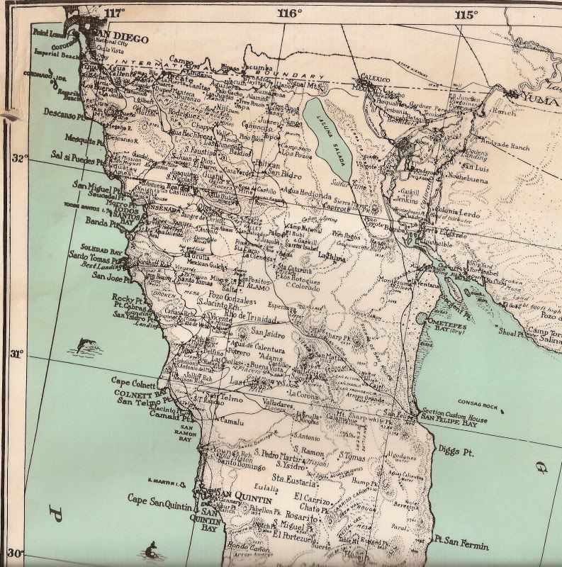
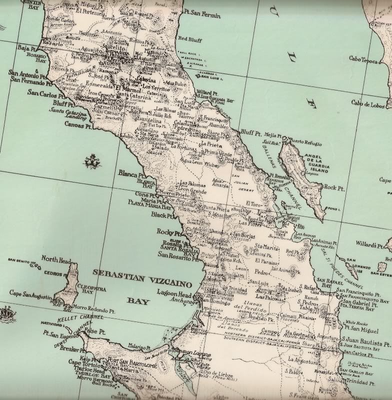
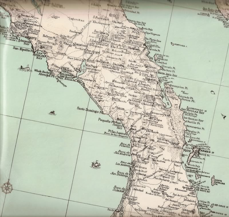
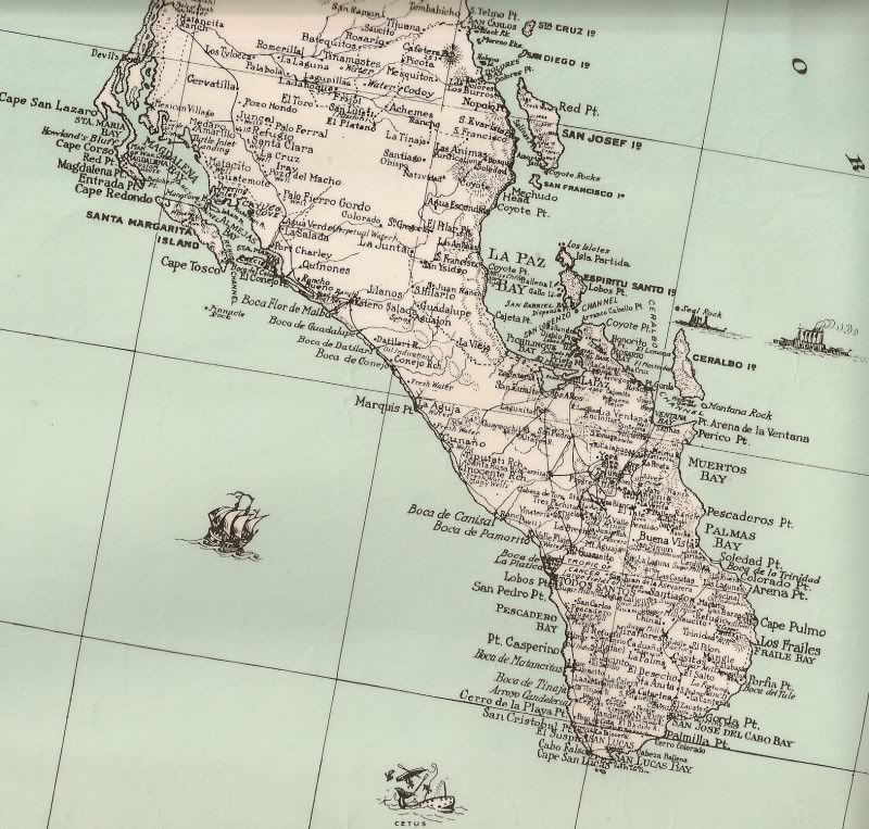
1930 Baja California Map
This is a very detailed map that was produced in San Diego in 1930...
[Edited on 11-13-2008 by David K]
|
|
|
fdt
Ultra Nomad
    
Posts: 4059
Registered: 9-7-2003
Location: Tijuana, Baja California
Member Is Offline
Mood: Yeah, what if it all goes right
|
|
A game?
As David K does, lets see if you can spot the other Tijuana on this map. According to another legend the word Tijuana comes from a place similar in
aspect of terrain (I've seen pictures) that is located in Baja California Sur and is also named Tijuana.
You can read about this place under Etymology here:
http://en.wikipedia.org/wiki/Tijuana
A well informed Baja California traveler is a smart Baja California traveler!
|
|
|
Hook
Elite Nomad
     
Posts: 9011
Registered: 3-13-2004
Location: Sonora
Member Is Offline
Mood: Inquisitive
|
|
David, these maps are very enjoyable to see, at least for me. Thank you for taking the time to upload them here.
You really are an incredible source of information on Baja. 
|
|
|
David K
Honored Nomad
        
Posts: 65294
Registered: 8-30-2002
Location: San Diego County
Member Is Offline
Mood: Have Baja Fever
|
|
Thank you Hook, I appreciate that from you...
|
|
|
fdt
Ultra Nomad
    
Posts: 4059
Registered: 9-7-2003
Location: Tijuana, Baja California
Member Is Offline
Mood: Yeah, what if it all goes right
|
|
David? Have you found the other Tijuana?
A well informed Baja California traveler is a smart Baja California traveler!
|
|
|
fdt
Ultra Nomad
    
Posts: 4059
Registered: 9-7-2003
Location: Tijuana, Baja California
Member Is Offline
Mood: Yeah, what if it all goes right
|
|
Anyone find the other Tijuana?
A well informed Baja California traveler is a smart Baja California traveler!
|
|
|
fdt
Ultra Nomad
    
Posts: 4059
Registered: 9-7-2003
Location: Tijuana, Baja California
Member Is Offline
Mood: Yeah, what if it all goes right
|
|
Still there today.
A well informed Baja California traveler is a smart Baja California traveler!
|
|
|
bajalou
Ultra Nomad
    
Posts: 4459
Registered: 3-11-2004
Location: South of the broder
Member Is Offline
|
|
I see it on 2 of the map posts.
No Bad Days
\"Never argue with an idiot. People watching may not be able to tell the difference\"
\"The trouble with doing nothing is - how do I know when I\'m done?\"
Nomad Baja Interactive map
And in the San Felipe area - check out Valle Chico area |
|
|
David K
Honored Nomad
        
Posts: 65294
Registered: 8-30-2002
Location: San Diego County
Member Is Offline
Mood: Have Baja Fever
|
|
Baja Sur's 'Tijuana' from space: Rancho Tijuana
|
|
|
fdt
Ultra Nomad
    
Posts: 4059
Registered: 9-7-2003
Location: Tijuana, Baja California
Member Is Offline
Mood: Yeah, what if it all goes right
|
|
That's it.
A well informed Baja California traveler is a smart Baja California traveler!
|
|
|
David K
Honored Nomad
        
Posts: 65294
Registered: 8-30-2002
Location: San Diego County
Member Is Offline
Mood: Have Baja Fever
|
|
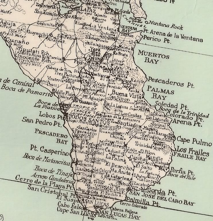
Close Up Cape Region 1930
That area is so 'busy', it is hard to make out the places... so here is a zoom in:
|
|
|
k-rico
Super Nomad
   
Posts: 2079
Registered: 7-10-2008
Location: Playas de Tijuana
Member Is Offline
|
|
Looks like if you started in TJ the furthest south you could get on some sort of road is San Quintin. Is that right?
|
|
|
David K
Honored Nomad
        
Posts: 65294
Registered: 8-30-2002
Location: San Diego County
Member Is Offline
Mood: Have Baja Fever
|
|
| Quote: | Originally posted by k-rico
Looks like if you started in TJ the furthest south you could get on some sort of road is San Quintin. Is that right? |
There were wagon roads made for the many mines... including El Marmol... Automobiles were pretty rare before WWII... I do have a photo of the first
auto to drive the peninsula (about 1928) and it wasn't easy!
The remote section was El Rosario to San Ignacio...
|
|
|
Skipjack Joe
Elite Nomad
     
Posts: 8088
Registered: 7-12-2004
Location: Bahia Asuncion
Member Is Offline
|
|
This map of baja seems advanced for it's time, except for the roads.
|
|
|
k-rico
Super Nomad
   
Posts: 2079
Registered: 7-10-2008
Location: Playas de Tijuana
Member Is Offline
|
|
If you look at the enlargement of the southern most map and go north out of Todos Santos you'll see an area where "fresh water" is marked. That's
interesting. Is there any development going on along the coast that far north of TS?
|
|
|
David K
Honored Nomad
        
Posts: 65294
Registered: 8-30-2002
Location: San Diego County
Member Is Offline
Mood: Have Baja Fever
|
|
On the edge of that image is Rancho La Aguja... that is where Nomad 'Rob' is... Other small places survived the 78 years since that map was made! Los
Inocentes is also on the Baja Almanac as it was in 1930...
|
|
|
David K
Honored Nomad
        
Posts: 65294
Registered: 8-30-2002
Location: San Diego County
Member Is Offline
Mood: Have Baja Fever
|
|
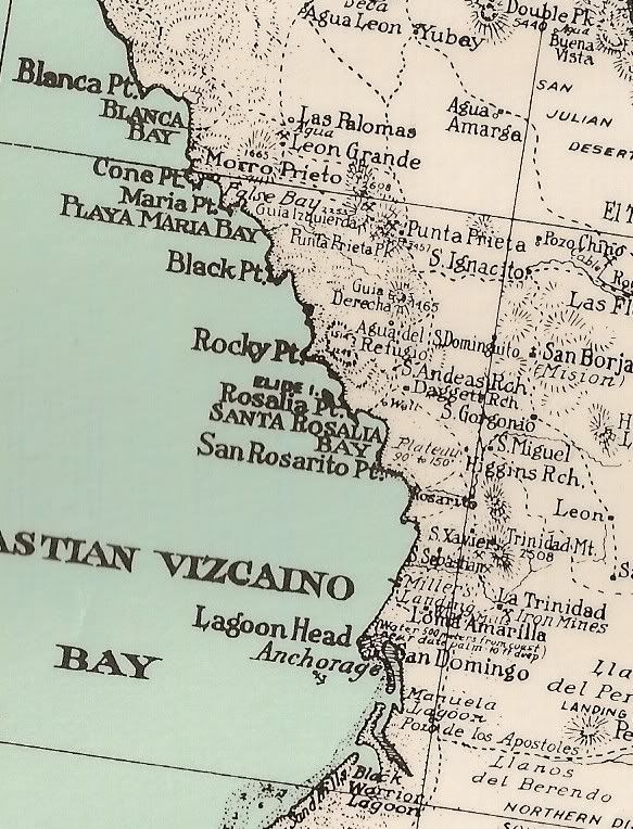
I would be happy to post a close up of any area of Baja that is of interst to you from this 1930 map or any of the other old maps I have posted on
this forum in the past!
Here is the Pacific coast from Punta Blanco to Laguna Guerrero Negro (Black Warrior Lagoon), for example:
|
|
|
Mulegena
Super Nomad
   
Posts: 2412
Registered: 11-7-2006
Member Is Offline
|
|
The camraderie here on this Thread shows the Best that Baja Nomad can be (o geez, i sound like a marine recruiter) but you know what I mean, right?
This is history and IT IS FUN!
|
|
|
smlslikfish
Junior Nomad

Posts: 75
Registered: 12-30-2003
Member Is Offline
Mood: La Costilla Bound
|
|
where did you find this map? I love old maps!  
|
|
|
smlslikfish
Junior Nomad

Posts: 75
Registered: 12-30-2003
Member Is Offline
Mood: La Costilla Bound
|
|
can you blow up the la costilla area page?
|
|
|
| Pages:
1
2
3 |

