| Pages:
1
2
3 |
David K
Honored Nomad

Posts: 65562
Registered: 8-30-2002
Location: San Diego County
Member Is Offline
Mood: Have Baja Fever
|
|
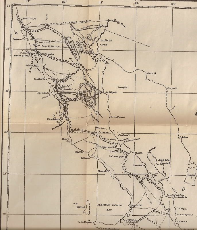
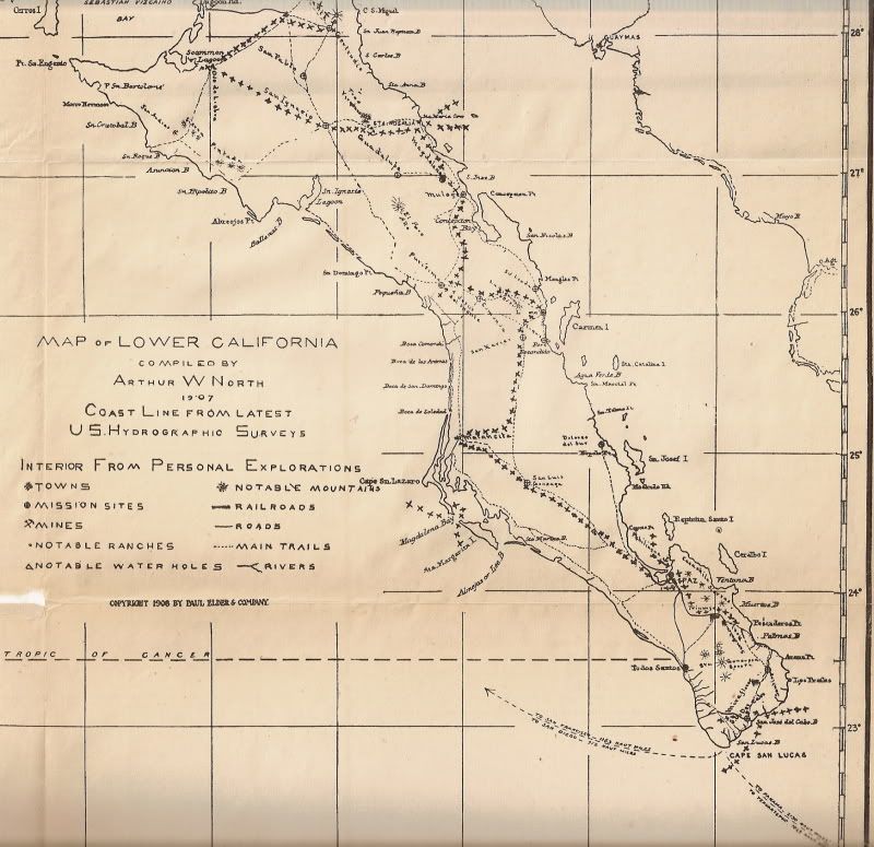
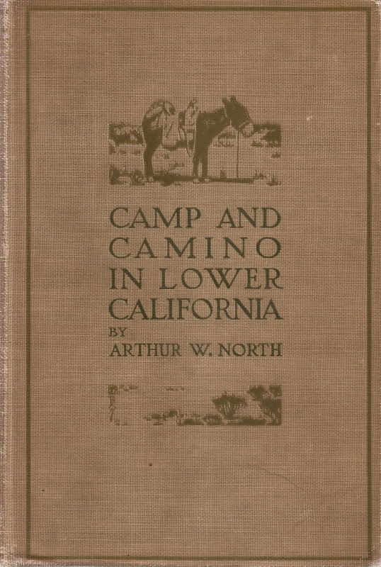
1907 Baja Map
From the 1910 book, 'Camp and Camino in Lower California' is this fold out map...
|
|
|
Barry A.
Select Nomad
Posts: 10007
Registered: 11-30-2003
Location: Redding, Northern CA
Member Is Offline
Mood: optimistic
|
|
Thanks for reminding me of that book, David. I just pulled it off my shelf to read again----------great book!!!!
Barry
|
|
|
capt. mike
Elite Nomad
Posts: 8085
Registered: 11-26-2002
Location: Bat Cave
Member Is Offline
Mood: Sling time!
|
|
very cool stuff.
formerly Ordained in Rev. Ewing\'s Church by Mail - busted on tax fraud.......
Now joined L. Ron Hoover\'s church of Appliantology
\"Remember there is a big difference between kneeling down and bending over....\"
www.facebook.com/michael.l.goering |
|
|
David K
Honored Nomad
Posts: 65562
Registered: 8-30-2002
Location: San Diego County
Member Is Offline
Mood: Have Baja Fever
|
|
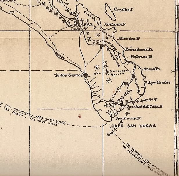
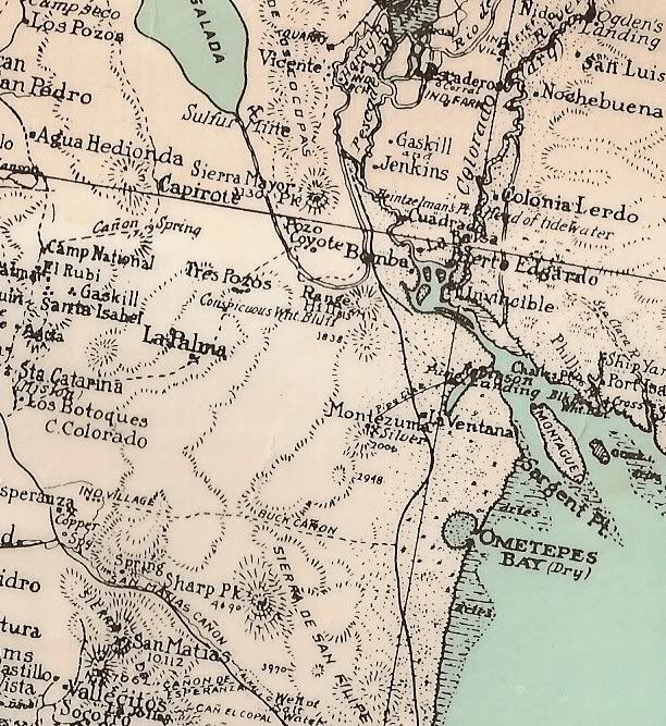
I posted close-up images of this map in this thread: http://forums.bajanomad.com/viewthread.php?tid=43742
and here are some of them:
From north to south (drawn my Arthur North showing his travel route through Baja in 1905-06:
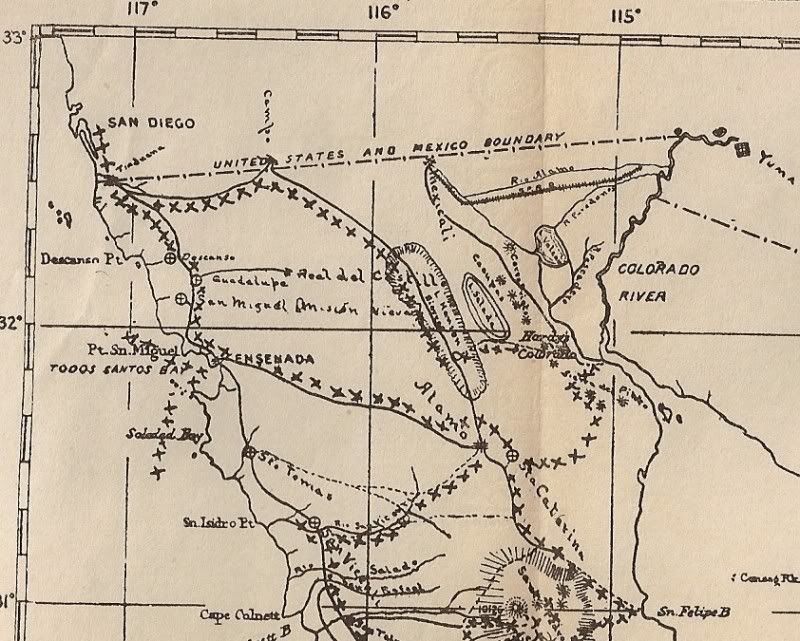
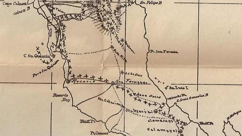
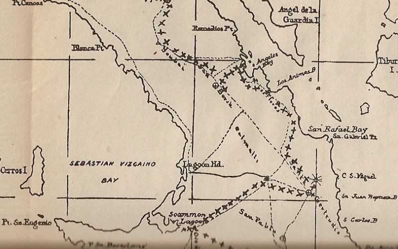
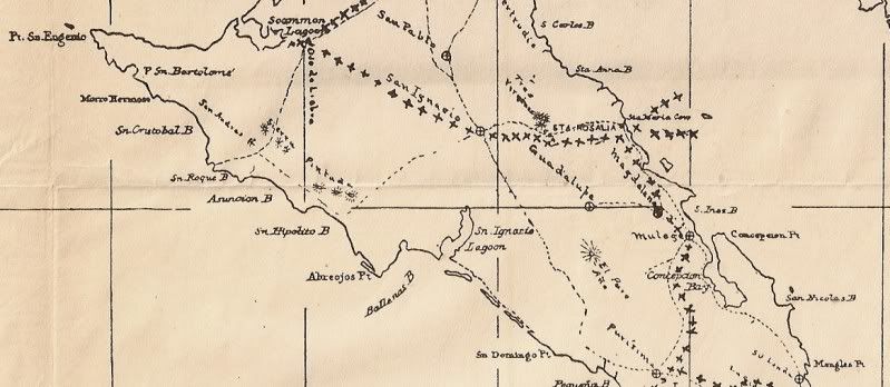
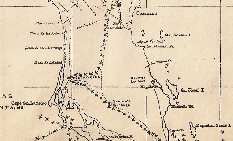
[Edited on 1-21-2010 by David K]
|
|
|
grmpb
Nomad
Posts: 103
Registered: 5-24-2009
Member Is Offline
|
|
great read. also check out graham mackintosh, journey with a baja burro. this trip roughly followed arthur north's trip a little less than a century
later.
|
|
|
David K
Honored Nomad
Posts: 65562
Registered: 8-30-2002
Location: San Diego County
Member Is Offline
Mood: Have Baja Fever
|
|
1997 trip...
Very good book! Order from Graham at http://grahammackintosh.com

Graham and Mision at San Fernando Velicata
[Edited on 1-21-2010 by David K]
|
|
|
LaTijereta
Super Nomad
Posts: 1192
Registered: 8-27-2003
Location: Loreto
Member Is Offline
|
|
| Quote: | Originally posted by grmpb
great read. also check out graham mackintosh, journey with a baja burro. this trip roughly followed arthur north's trip a little less than a century
later. |
These guys followed Col. North's trail in 1963.. Then published great book with images of the missions..

Democracy is like two wolves and a lamb voting on what to have for lunch. Liberty is a well-armed lamb contesting the vote.
Ben Franklin (1759)
|
|
|
David K
Honored Nomad
Posts: 65562
Registered: 8-30-2002
Location: San Diego County
Member Is Offline
Mood: Have Baja Fever
|
|
Actually... it was early than that Kris! They were down there in 1949 to 1950... and the book was finally published in 1968. A great adventure and
they were so determined to find all the mission sites. I use several of their photos to show the sites as they appeared over 50 years ago.
|
|
|
Cisco
Ultra Nomad
Posts: 4196
Registered: 12-30-2010
Member Is Offline
|
|
| Quote: | Originally posted by David K
I posted close-up images of this map in this thread: http://forums.bajanomad.com/viewthread.php?tid=43742
and here are some of them:
From north to south (drawn my Arthur North showing his travel route through Baja in 1905-06:
[Edited on 1-21-2010 by David K] |
Very nice. Thank you.
That was a time when the Colorado River was flowing freely also. Must have been a different environment on the NE part of the peninsula. Was there any
reference to that David?
The Colorado used to scour itself, bring huge boulders and wash material down with it. Now of course, since damming, the flow has been so restricted
it has sand beaches and silt in places and of course very little water even enters the Gulf today.
|
|
|
David K
Honored Nomad
Posts: 65562
Registered: 8-30-2002
Location: San Diego County
Member Is Offline
Mood: Have Baja Fever
|
|
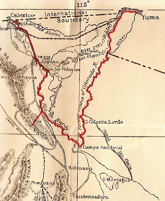
Sure... there were paddle boats that brought supplies off loaded at 'Port Isabel', Sonora to Yuma, Arizona! Port Isabel was at the mouth of the river,
north of El Golfo. There were shipyards there... may be an interesting place to explore?
See it on the right edge of this 1930 map:
[Edited on 4-3-2013 by David K]
|
|
|
Ateo
Elite Nomad
Posts: 5962
Registered: 7-18-2011
Member Is Offline
|
|
Do we know who named the points of the 7 sisters? This is not a trick question -- I'm asking.
|
|
|
David K
Honored Nomad
Posts: 65562
Registered: 8-30-2002
Location: San Diego County
Member Is Offline
Mood: Have Baja Fever
|
|
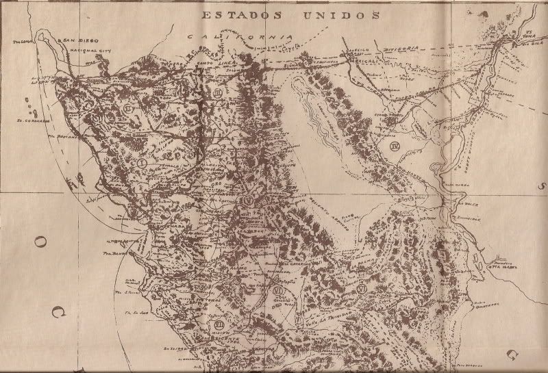
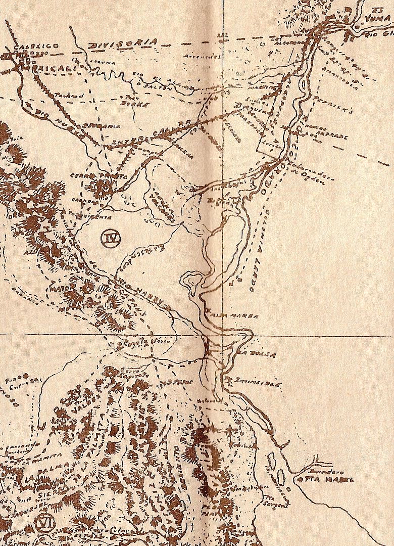
Here is a 1919 map:
|
|
|
David K
Honored Nomad
Posts: 65562
Registered: 8-30-2002
Location: San Diego County
Member Is Offline
Mood: Have Baja Fever
|
|
| Quote: | Originally posted by Ateo
Do we know who named the points of the 7 sisters? This is not a trick question -- I'm asking. |
Don't ask me, somehow I will get in trouble... How about who named 'Scorpion Bay' or 'Zippers' or '
Shipwrecks'...  
|
|
|
David K
Honored Nomad
Posts: 65562
Registered: 8-30-2002
Location: San Diego County
Member Is Offline
Mood: Have Baja Fever
|
|
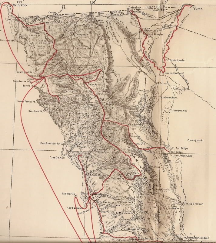
Here is Nelson's 1919 map...
|
|
|
David K
Honored Nomad
Posts: 65562
Registered: 8-30-2002
Location: San Diego County
Member Is Offline
Mood: Have Baja Fever
|
|
| Quote: | Originally posted by Cisco
Very nice. Thank you.
That was a time when the Colorado River was flowing freely also. Must have been a different environment on the NE part of the peninsula. Was there any
reference to that David?
The Colorado used to scour itself, bring huge boulders and wash material down with it. Now of course, since damming, the flow has been so restricted
it has sand beaches and silt in places and of course very little water even enters the Gulf today. |
From Wikipedia...

Port Isabel was a seaport established in 1865 during the American Civil War in Sonora, Mexico near the mouth of the Colorado River on the Sea of
Cortez to support the increased river traffic caused by the gold rush that began in 1862 on the Colorado River and the Yuma Quartermaster Depot newly
established in 1864 to support the Army posts in the Arizona Military District.
Port Isabel replaced Robinson's Landing as the place where cargo was unloaded in the river from seagoing craft on to flatbottomed steamboats and
carried up to Fort Yuma and points further north on the river.[1]
Port Isabel, was situated on the east bank of the Colorado River on its channel east of Montague Island about 21⁄2 miles from its mouth, at the
first good landing place, the shores below being of very soft mud. Port Isabel, served as a location for repairing the river steamers and barges.
Additionally about 2 miles above Port Isabel was a site called Ship Yard, which had a few frame buildings where steamboats could be constructed or
repaired.[2]
The arrival of the Southern Pacific Railroad in Yuma in 1877 signaled the end of Port Isabel. Trade by sea was replaced with cargo carried by rail. In
1878, George Alonzo Johnson sold his Colorado Steam Navigation Company to the Southern Pacific Railroad. Yuma then became the head of navigation for
steamboats operating on the river. Port Isabel was abandoned in 1879.
|
|
|
David K
Honored Nomad
Posts: 65562
Registered: 8-30-2002
Location: San Diego County
Member Is Offline
Mood: Have Baja Fever
|
|
Colorado River Ports
Here is a map drawn from Nelson's 1905 expedition and published in 1919:
================================================
Here is Goldbaum's 1919 map:
|
|
|
Mexitron
Ultra Nomad
Posts: 3397
Registered: 9-21-2003
Location: Fort Worth, Texas
Member Is Offline
Mood: Happy!
|
|
No "roads" in Baja from San Fernando (access road to Puerto Catarina?) to La Paz except for the access to Calmalii from (Laguna Manuela?)...but
already a coastal trail through the Seven Sisters---must have had all the waves to themselves
|
|
|
David K
Honored Nomad
Posts: 65562
Registered: 8-30-2002
Location: San Diego County
Member Is Offline
Mood: Have Baja Fever
|
|
Sure there were roads... for mules, burros, horses, some may have allowed wagons... The first automobiles to travel south of El Marmol to San Ignacio
were in the 1920's.
The Camino Real was the 'mission road' created from the late 1600's to 1834 (the year the last mission was founded in 'California'. The 1907 maps in
this thread show Arthur North's rides on some of the mission roads and other trails.
|
|
|
Cisco
Ultra Nomad
Posts: 4196
Registered: 12-30-2010
Member Is Offline
|
|
| Quote: | Originally posted by David K
| Quote: | Originally posted by Cisco
Very nice. Thank you.
That was a time when the Colorado River was flowing freely also. Must have been a different environment on the NE part of the peninsula. Was there any
reference to that David?
The Colorado used to scour itself, bring huge boulders and wash material down with it. Now of course, since damming, the flow has been so restricted
it has sand beaches and silt in places and of course very little water even enters the Gulf today. |
From Wikipedia...
Port Isabel was a seaport established in 1865 during the American Civil War in Sonora, Mexico near the mouth of the Colorado River on the Sea of
Cortez to support the increased river traffic caused by the gold rush that began in 1862 on the Colorado River and the Yuma Quartermaster Depot newly
established in 1864 to support the Army posts in the Arizona Military District.
Port Isabel replaced Robinson's Landing as the place where cargo was unloaded in the river from seagoing craft on to flatbottomed steamboats and
carried up to Fort Yuma and points further north on the river.[1]
Port Isabel, was situated on the east bank of the Colorado River on its channel east of Montague Island about 21⁄2 miles from its mouth, at the
first good landing place, the shores below being of very soft mud. Port Isabel, served as a location for repairing the river steamers and barges.
Additionally about 2 miles above Port Isabel was a site called Ship Yard, which had a few frame buildings where steamboats could be constructed or
repaired.[2]
The arrival of the Southern Pacific Railroad in Yuma in 1877 signaled the end of Port Isabel. Trade by sea was replaced with cargo carried by rail. In
1878, George Alonzo Johnson sold his Colorado Steam Navigation Company to the Southern Pacific Railroad. Yuma then became the head of navigation for
steamboats operating on the river. Port Isabel was abandoned in 1879. |
Neat, neat, neat.
Gracias for the thread and research David. Fascinating stuff.
|
|
|
Mexitron
Ultra Nomad
Posts: 3397
Registered: 9-21-2003
Location: Fort Worth, Texas
Member Is Offline
Mood: Happy!
|
|
| Quote: | Originally posted by David K
Sure there were roads... for mules, burros, horses, some may have allowed wagons... The first automobiles to travel south of El Marmol to San Ignacio
were in the 1920's.
The Camino Real was the 'mission road' created from the late 1600's to 1834 (the year the last mission was founded in 'California'. The 1907 maps in
this thread show Arthur North's rides on some of the mission roads and other trails. |
I know---I put roads in quotes, as per the map's symbol for automobile roads!
Have any pics of that era? Be neat to compare any plant growth seen in the last hundred years, as per your other thread...
|
|
|
| Pages:
1
2
3 |


