David K
Honored Nomad

Posts: 65590
Registered: 8-30-2002
Location: San Diego County
Member Is Offline
Mood: Have Baja Fever
|
|
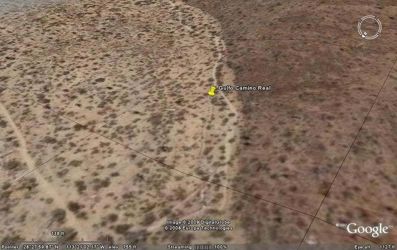
ECR-2b) GOLFO CAMINO REAL, from space (the east branch south from San Borja)
Between Santa Gertrudis and San Borja there were three El Camino Real routes. The most well known in the central or SIERRA CAMINO REAL (see my
previous post on it)... and is the route Junipero Serra traveled on his walk from Loreto to San Diego and beyond, in 1769.
The PACIFICO CAMINO REAL is to the west of the Sierra or main El Camino Real, and is the least known route.
In this installment we sall have a look at the GOLFO CAMINO REAL south from San Borja... maps will follow the photos so you can see where the photo is
looking...
The images from space are all taken looking southbound, just above the trail.
The San Borja Airport (dirt field, just south of the mission in the higher valley)... The central Camino Real heads straight south, the west branch
veers right towards Santa Ana, and the east 'Golfo' branch goes off to the left (auto roads are on top of the east and west branches for a few miles
from here).

Heading southeast towards Rancho San Gregorio and the access to the San Juan mines.

Nearing the San Juan/ San Gregorio junction.

San Gregorio is an abandoned ranch that dates back to mission times... built upon cut stone blocks in a side canyon 1/4 mile from the end of the auto
road. See photos taken there at http://vivabaja.com/401/page5.html

El Aguaje de San Juan... See Neal Johns' photos taken there http://vivabaja.com/neal/page4.html

The top of the sierra! See the Gulf of California?

Halfway down to the desert.

Utilizing a sandy arroyo for some of the route out of the mountain, the Golfo Camino Real turns south and heads towards Valle San Pedro. At this
point, a trail (perhaps traveled by autos) comes in from the northeast.

Top of the divide between the Llano San Vicente and the Valle San Pedro. The mission trail switchback can be seen on the left, and a newer (auto?)
route is on the right.

In the Valle San Pedro. Beyond here only a couple places can the old trail be seen until reaching Rancho La Bocana (mis named San Pedro on the map).

MORE IMAGES AFTER MAP...
This first map is a close up to show the first 10 images (labled G1 to G10):

Continued...
[Edited on 2-25-2009 by David K]
|
|
|
David K
Honored Nomad
Posts: 65590
Registered: 8-30-2002
Location: San Diego County
Member Is Offline
Mood: Have Baja Fever
|
|
Rancho La Bocana (mis-labled San Pedro in the topo maps) is on the Gulfo Camino Real where the arroyo leaves the mountain and spills out into the
Valle La Bocana. Themission trail keeps to the right, along the base of the hills. The auto road is right on top of it for a short distance.
G11)

Here the Gulfo Camino Real follows the side of the hill as the auto road heads on eastward towards Bahia San Rafael or Punta San Francisquito. (This
is the original auto road from the Gardner party trip of 1966).
G12)
Here the trail can be seen in the hazey photo as it climbs a ridge and drops to the valley behind.
G13)

Just south of the side canyon to Tinaja Santa Maria, the Camino Real heads south, then southwest.
G14) 
The trail is faint as it climbs another mountain.
G15) 
Top of the ridge and the peninsular divide as the trail continues.
G16)

Along Arroyo El Valle... heading downhill.
G17)

An auto road is over the top of the route of the Gulfo Camino here, where it meets the central El Camino Real for the remainder of the trip to Santa
Gertrudis.
G18)

Map... showing the second group of images location:

Here's with the trail located and Tinaja Santa Maria shown:

[Edited on 12-26-2008 by David K]
|
|
|
David K
Honored Nomad
Posts: 65590
Registered: 8-30-2002
Location: San Diego County
Member Is Offline
Mood: Have Baja Fever
|
|
The link to the first thread, covering the central or 'SIERRA' El Camino Real from San Borja to Santa Gertrudis (ECR-2a) is here: http://forums.bajanomad.com/viewthread.php?tid=36002
[Edited on 2-25-2009 by David K]
|
|
|
Ken Cooke
Elite Nomad
Posts: 8971
Registered: 2-9-2004
Location: Riverside, CA
Member Is Offline
Mood: Pole Line Road postponed due to injury
|
|
Very interesting research you are doing on the region, David. Thanks for sharing this.
Ken...the one with a Jeep.  
|
|
|
David K
Honored Nomad
Posts: 65590
Registered: 8-30-2002
Location: San Diego County
Member Is Offline
Mood: Have Baja Fever
|
|
My pleasure Ken!
The next thing I will show is the Camino Real going NORTH from San Borja to Mision Santa Maria... Unlike the trail routes going south from San Borja,
the route north is right on or very near auto roads, in many places.
I am not sure if I will get to this project before our Baja trip in 3 days...
Happy New Year!
|
|
|
airmech
Nomad
Posts: 184
Registered: 9-2-2006
Location: Murrieta Ca
Member Is Offline
Mood: Expeditionary
|
|
That google earth is cool. With a little work I felt like I was right there looking at San Borja..... bg

Both optimists and pessimists contribute to the society. The optimist invents the aeroplane, the pessimist the parachute.
George Bernard Shaw
|
|
|
David K
Honored Nomad
Posts: 65590
Registered: 8-30-2002
Location: San Diego County
Member Is Offline
Mood: Have Baja Fever
|
|
Almost like flying over it! 
|
|
|