| Pages:
1
2 |
David K
Honored Nomad

Posts: 64493
Registered: 8-30-2002
Location: San Diego County
Member Is Offline
Mood: Have Baja Fever
|
|
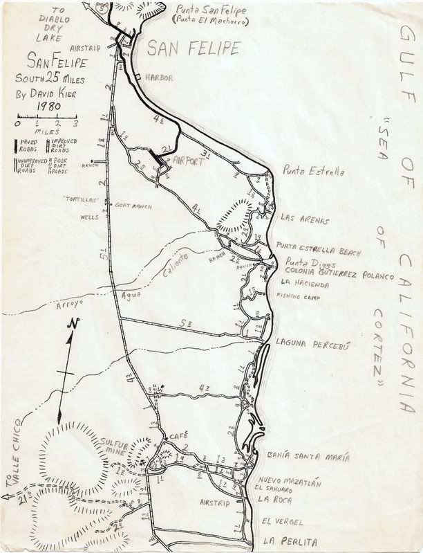
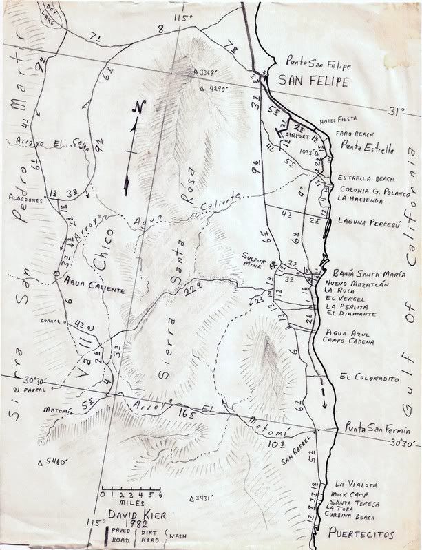
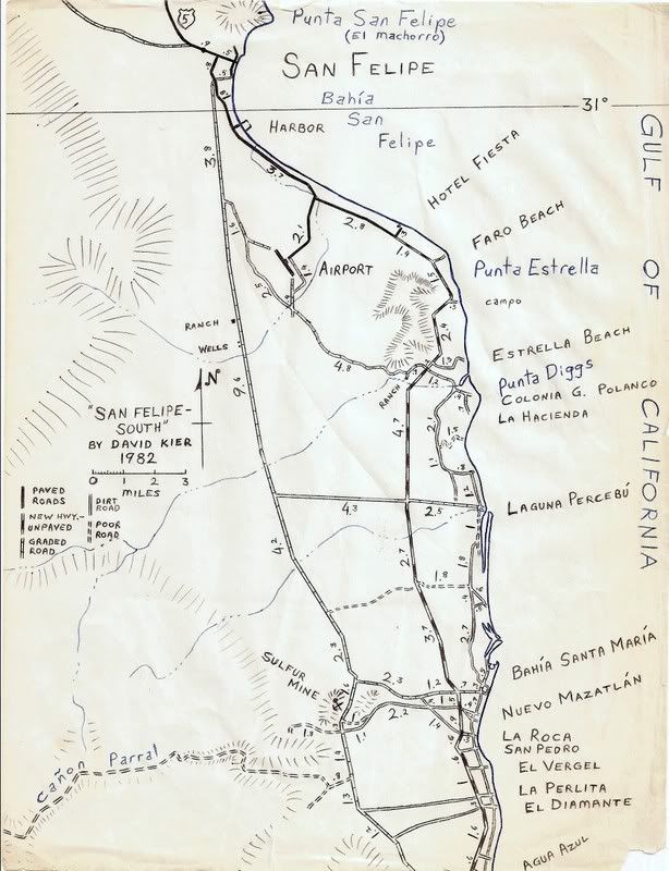
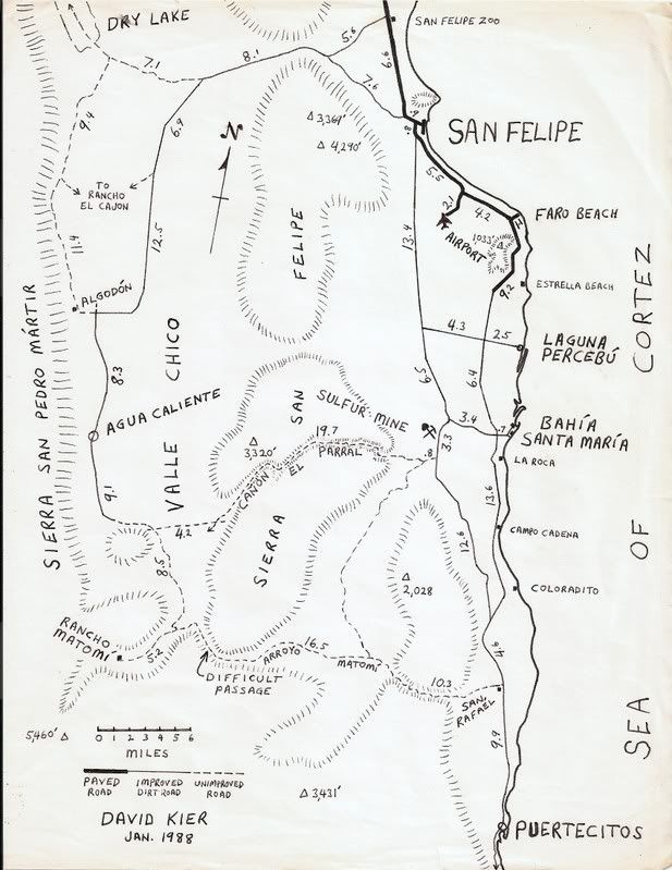
My San Felipe Area Maps 1967-1988
I have loved drawing maps since I was a kid... wish I could find them all... but we are talking a long time! 
This is all because of Baja and the love I have for the place. If I drew a map of where we camped, then I could look at the map and 'be there', when I
wasn't! I also have wanted to help others get to enjoy Baja the way I did, and made copies of my maps for others.
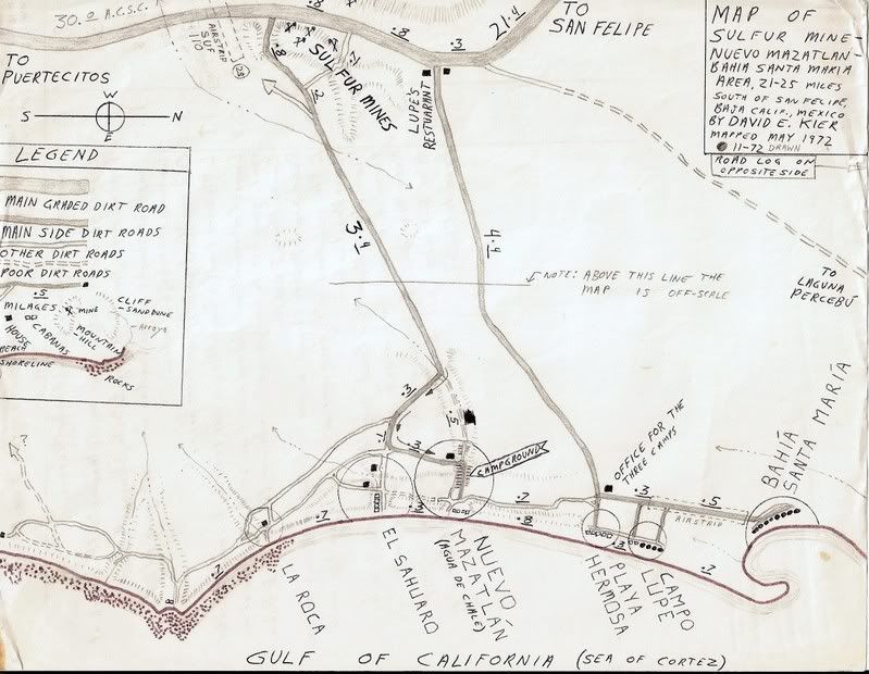
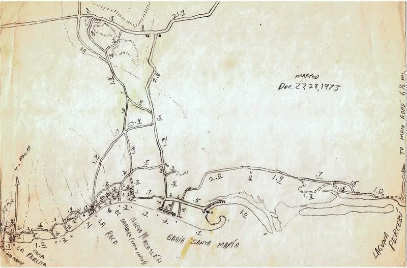
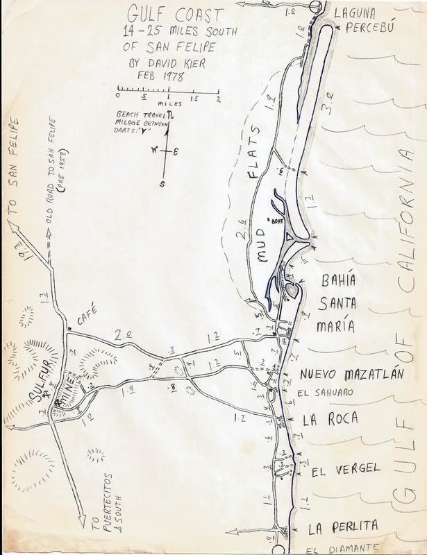
Here are 8 samples of the maps I drew of the area south of San Felipe where we went most often... You can see how rough the first ones were... Heck, I
was 9 or 10 years old when I drew the first one here (1967)!
The next ones ('72, '73), I used my mini bike (Honda Trail 70) and its odometer to check out all the roads near Nuevo Mazatlan.
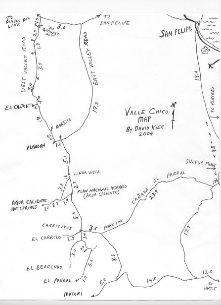
When I started camping out of my Subaru, I began exploring the arroyos heading inland and found the 'lost road' to Valle Chico in 1978, I had heard
about in a 1967 guide, but it was unused for many years, and was hard to find... that was the Cañada el Parral road (Azufre Wash) that has (since my
mapping it and telling Sal Fish about it), been a regular route through the coastal sierra.
Okay, 1967, 10 years old:
1972, 14 years old:
1973:
1978:
1980:
1982, the new road to Puertecitos was being built:
1988, this one appeared in the Mexico West newsletter with my article about the progress of the Puertecitos road. On the same page was a letter from
Baja Bucko... Neal Johns spotted that coincidence, 15 years later when we all knew each other!:
|
|
|
Barry A.
Select Nomad
Posts: 10007
Registered: 11-30-2003
Location: Redding, Northern CA
Member Is Offline
Mood: optimistic
|
|
David-----------It is great to see how your map-skills progressed over the years----------those are really GREAT maps, all of them. I KNOW you
really had fun making them, and ground-truthing all the details and mileages-------I did some of the same, but never as professionally as you have
done.
What kind of shape was the "Canada el Parral" road to Valle Chico in when you found it?? (love that road) Were you able to make it thru to Valle
Chico in your Subaru??
I have camped right on the "pass" at the top of that canyon several times and it is a wonderful, quiet place to camp.
Barry
|
|
|
David K
Honored Nomad
Posts: 64493
Registered: 8-30-2002
Location: San Diego County
Member Is Offline
Mood: Have Baja Fever
|
|
| Quote: | Originally posted by Barry A.
David-----------It is great to see how your map-skills progressed over the years----------those are really GREAT maps, all of them. I KNOW you
really had fun making them, and ground-truthing all the details and mileages-------I did some of the same, but never as professionally as you have
done.
What kind of shape was the "Canada el Parral" road to Valle Chico in when you found it?? (love that road) Were you able to make it thru to Valle
Chico in your Subaru??
I have camped right on the "pass" at the top of that canyon several times and it is a wonderful, quiet place to camp.
Barry |
Thank you!
Yes, it was exciting... every trip after I read about the 'Sulphur Mine to Valle Chico' road (Robinson's 'Camping and Climbing in Baja' 1967 edition,
but not in the later editions!) and saw it on a highly detailed geology map of Baja norte from 1974.... I searched for that road.
On a rainy Christmas vacation trip (1978) with friends in my Subaru we found the route... and it took most of the day to get through... moving rocks,
scouting the route in the inner valley, and finding the exit route in Valle Chico!
The wet weather had sprouted grass seedlings in the places were water collected... the depression of vehicle tracks, otherwise invisible... we looked
for 'parallel grass'!
On the Valle Chico side, were the original road crossed the arroyo in the bottom/ center of the valley (before that fence line was installed across
the valley, we use today), we could not find the road on the other side of the wide wash, so we drove up the wash (south) knowing it would sooner or
later cross the road down to Rancho Matomi! It did... and there was even a SCORE ribbon I spotted from the '78 Baja 1000 a month earlier... It was the
first time the Baja 1000 went down Valle Chico and Arroyo Matomi.
You can see my mileages on the old route then in the arroyo.
We turned north for San Felipe as we had no time to see Matomi (for the first time) that trip...
I returned soon after and did get into Arroyo Matomi, and almost up to Tomas Dowling's upper/ second ranch location before a flash flood almost took
my Subaru from me! (see photo, below)
The following summer I did get up to the second ranch, and we swam in the oasis pool... great fun on a hot day!
The lower or first ranch house was on the ledge along the grade that drops into Arroyo Matomi from Valle Chico... It was totally removed follwing
Tomas' death... in the 80's?
[Edited on 2-1-2009 by David K]

|
|
|
BajaNuts
Super Nomad
Posts: 1085
Registered: 5-11-2008
Location: eastern WA, the DRY side
Member Is Offline
Mood: no worry, no hurry....it's all good!
|
|
very interesting, and some really great talent also!
To make those maps as a kid is really great. Thanks for sharing
|
|
|
Sharksbaja
Elite Nomad
Posts: 5814
Registered: 9-7-2004
Location: Newport, Mulege B.C.S.
Member Is Offline
|
|
Those are great David! I can imagine how much time and effort you poured into them. A great evolving hobby indeed.
Without really studying them closely some changes from map to map jump out dramatically.
I'm surprised you didn't persue a career in cartography or similar. Some of those early maps are pretty professional looking.
Say, do you have any more recent ones of that area?
Thanks for sharing.
[Edited on 2-2-2009 by Sharksbaja]
DON\'T SQUINT! Give yer eyes a break!
Try holding down [control] key and toggle the [+ and -] keys
Viva Mulege!
Nomads\' Sunsets
|
|
|
David K
Honored Nomad
Posts: 64493
Registered: 8-30-2002
Location: San Diego County
Member Is Offline
Mood: Have Baja Fever
|
|
Thanks guys...
Yes, I was going to be a cartographer... it was on a field trip with the geography class I was in (along with the geology class) to Death Valley that
I met a girl... who introduced me later to her sister... who's boyfriend and her owned a drip irrigation business... and that changed everything!!!
The most recent update of my San Felipe area (Valle Chico) map is ... this 2004 updated one from my trip with Jide http://vivabaja.com/404
[Edited on 2-2-2009 by David K]
|
|
|
makana.gabriel
Nomad
Posts: 115
Registered: 1-10-2008
Location: Honolulu
Member Is Offline
|
|
Wow David. Those maps are fabulous. Totally professional. Thanks for sharing!!!
FAITH sees the invisible, believes the incredible, and receives the impossible!
|
|
|
David K
Honored Nomad
Posts: 64493
Registered: 8-30-2002
Location: San Diego County
Member Is Offline
Mood: Have Baja Fever
|
|
Thanks for the nice words... and you're welcome!
I figure that if I put enough energy into making a map that shows the places we love, it should be good enough to share.
These maps have been posted on the Internet before... both here on Nomad and on the former Amigos de Baja forum... However, there are many new people
online now who may enjoy these again.
I have many more... Perhaps in other threads depending on the area... I will post...
|
|
|
David K
Honored Nomad
Posts: 64493
Registered: 8-30-2002
Location: San Diego County
Member Is Offline
Mood: Have Baja Fever
|
|
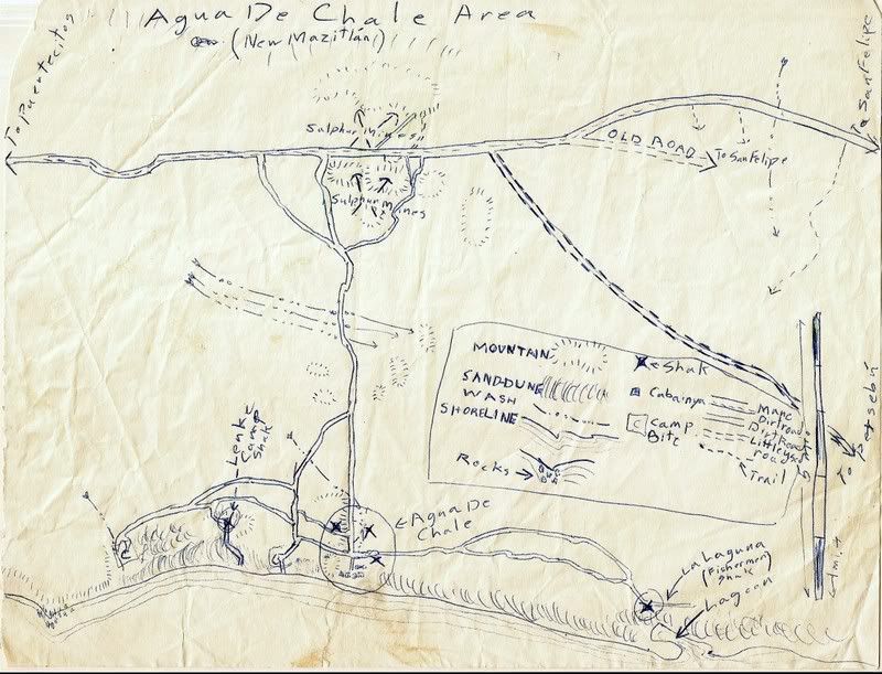
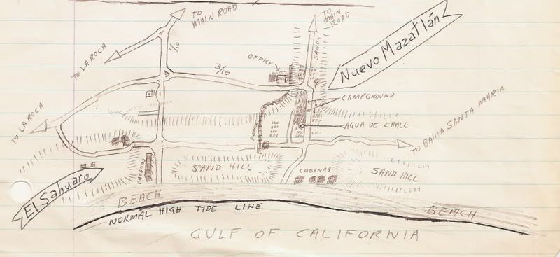
When I was about 14, I was writing a guidebook outline for parts of Baja... This one sketch map is like the Cliff Cross style, bird's eye view...
Nuevo Mazatlan about 1972
|
|
|
BornFisher
Super Nomad
Posts: 2103
Registered: 1-11-2005
Location: K-38 Santa Martha/Encinitas
Member Is Offline
|
|
Wow! I used to draw treasure maps when I was a kid but even I couldn`t follow them (lost a few treasures!).
Great work!!!
|
|
|
BajaWarrior
Super Nomad
Posts: 2307
Registered: 9-27-2006
Location: Mission Bay, San Diego. Playa Hermosa, San Felipe.
Member Is Offline
Mood: Anxious to get south
|
|
David,
I dont see Quartz Mtn on any of your maps. Have you been there?
Haven't had a bad trip yet....
|
|
|
David K
Honored Nomad
Posts: 64493
Registered: 8-30-2002
Location: San Diego County
Member Is Offline
Mood: Have Baja Fever
|
|
| Quote: | Originally posted by BajaWarrior
David,
I dont see Quartz Mtn on any of your maps. Have you been there? |
Chuck, that sounds like a 'gringo' name... Is that in Bruce Barber's book? I will look and see... stand by!

|
|
|
Bob H
Elite Nomad
Posts: 5867
Registered: 8-19-2003
Location: San Diego
Member Is Offline
|
|
David, those maps are just great! Thanks for sharing the comparison of your skills as you got older. They are all fantastic maps.
Bob H
|
|
|
David K
Honored Nomad
Posts: 64493
Registered: 8-30-2002
Location: San Diego County
Member Is Offline
Mood: Have Baja Fever
|
|
| Quote: | Originally posted by David K
| Quote: | Originally posted by BajaWarrior
David,
I dont see Quartz Mtn on any of your maps. Have you been there? |
Chuck, that sounds like a 'gringo' name... Is that in Bruce Barber's book? I will look and see... stand by! |
Okay Chuck, as I suspected... it is in Bruce's book on page 211! The answer is no, I have not been on either Chanate or Huatamote arroyos as they were
not 'roads' back in the days I did my extensive mapping 30 years ago.
Bruce calls Cañada el Parral (Azufre Wash): 'Crazy Horse' Canyon in his book because of the twists and turns in it.. Great book of information on the
San Felipe area canyons and geology sites... it is just hard to follow with the way it was edited. I still recommend any San Felipe area off roader/
explorer get it for the details.
|
|
|
David K
Honored Nomad
Posts: 64493
Registered: 8-30-2002
Location: San Diego County
Member Is Offline
Mood: Have Baja Fever
|
|
| Quote: | Originally posted by Bob H
David, those maps are just great! Thanks for sharing the comparison of your skills as you got older. They are all fantastic maps.
Bob H |
Thanks Bob...
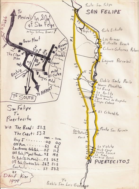
I found another of my maps from 30 years ago... It compares driving to Puertecitos on the beach and on the road, from San Felipe... on the town map,
notice I point out the Clam Man!
|
|
|
Festus
Junior Nomad
Posts: 52
Registered: 2-22-2008
Location: San Francisco
Member Is Offline
Mood: Inquisitive
|
|
| Quote: | Originally posted by David K
Thanks guys...
Yes, I was going to be a cartographer... it was on a field trip with the geography class I was in (along with the geology class) to Death Valley that
I met a girl... who introduced me later to her sister... who's boyfriend and her owned a drip irrigation business... and that changed everything!!!
The most recent update of my San Felipe area (Valle Chico) map is ... this 2004 updated one from my trip with Jide http://vivabaja.com/404
[Edited on 2-2-2009 by David K] |
Nice map. We are headed to SF for the week of 4/11. I have a stock Toyota Highlander 4X4. Will I be able to take it over these trails? Would be
fun to get out and explore a little.
[Edited on 2-13-2009 by Festus]
Friendship... is not something you learn in school. But if you haven\'t learned the meaning of friendship, you really haven\'t learned
anything.
Muhammad Ali
|
|
|
David K
Honored Nomad
Posts: 64493
Registered: 8-30-2002
Location: San Diego County
Member Is Offline
Mood: Have Baja Fever
|
|
YES... specially because it is a TOYOTA  
All the roads shown I drove in one of my Tacomas... 4WD was only needed for deep sand in Arroyo Berrendo & Arroyo Matomi, and getting to the end
of the road in Agua Caliente canyon.
Photos in my web site...
|
|
|
David K
Honored Nomad
Posts: 64493
Registered: 8-30-2002
Location: San Diego County
Member Is Offline
Mood: Have Baja Fever
|
|
I have been emailing with Bruce Barber, the '... of Sea and Sand' author, and he has given me the okay to quote from his book. I plan on showing a map
from his book, then list what places the book details on each of his maps... His book should be in your collection if you ever go exploring the desert
around San Felipe or Laguna Salada... See http://community-2.webtv.net/boojum1/barber for ordering details.
|
|
|
4x4abc
Ultra Nomad
Posts: 4170
Registered: 4-24-2009
Location: La Paz, BCS
Member Is Offline
Mood: happy - always
|
|
excellent for all the campo names
Harald Pietschmann
|
|
|
David K
Honored Nomad
Posts: 64493
Registered: 8-30-2002
Location: San Diego County
Member Is Offline
Mood: Have Baja Fever
|
|
Her is my list from 2018 (*with added names made by South Campos Amigos):
Km. 0 Airport Road (6.1 miles from San Felipe traffic circle)
Km. 1 La Hacienda
Km. 6 San Fernando*
Km. 6.5 Residence "Camping" (El Faro Beach)
Km. 6.5+ La Perla del Mar*
Km. 8.5 Villa Marina RV Park.
Km. 8.5 Del Cielo a la Playa*
Km. 9 Campo Lobo*
Km. 11 La Jolla del Mar
Km. 12 Punta Estrella Beach
Km. 14+ Valle de los Gigantes
Km. 15.5 Pancho's
Km. 17 Rancho Los Potrillos
Km. 20.5+ Rancho Percebu.
Km. 26+ Shell Island access road (4WD)
Km. 31 BahÃa Santa MarÃa/ San Carlos*/ La Misión/ Playa Hermosa
Km. 31.5 Baja Beach Resort
Km. 32 Nuevo Mazatlán
Km. 32 El Sahuaro
Km. 32.5 La Joya*
Km. 33 Playa Linda
Km. 33.5 La Roca
Km. 34 Campo Delicias
Km. 34+ San Pedro.
Km. 35 Fire Station*
Km. 35+ El Vergel
Km. 35.5 Lupita*
Km. 35.5-36 Colonia Delicias (TOWN) See note D, below.
Km. 36 Esmeralda*
Km. 36.5 OM BAJA/ Punta Loma*
Km. 36.5+ La Perlita
Km. 37.5 Diamante
Km. 37.5+ Santa Fe
Km. 38 Rancho Villa del Mar*
Km. 38.5+ San Martin
Km. 39.5 Garcia
Km. 39.5+ Playa Mexico
Km. 40+ Rancho Anita
Km. 40.5 Cielito Lindo
Km. 40.5+ Agua Azul
Km. 41.5 Campo Cadena
Km. 42+ Campo Jimenez
Km. 42.5 Los Gorditos
Km. 43 San Antonio*
Km. 43.5 Pelicano
Km. 44 Campo Badilla.
Km. 44.5 Playa Gabriela*
Km. 45 Playa Adriana
Km. 45.5 Mar y Sol
Km. 45.5 Los Morritios
Km. 46 San José
Km. 47 Rudy's Camp
Km. 47.5 San Francisco
Km. 49 Los Pulpos
Km. 49+ Rancho Las Panteras (El Coloradito Parcela 55)
Km. 49.5 Consuelo (at curve in highway)
Km. 51.5 Playa El Sueño
Km. 52.5 Old Puertecitos Road (Score Race Route)
Km. 52.5+ Costa Verde
Km. 54.5 Playa Cristina
Km. 58.5 Los Olivos
Km. 60 Arroyo MatomÃ
Km. 60.5 El Pozo
Km. 61-72.5+ DETOUR for new highway work.
Km. 65 El Conquistador
Km. 68.5+ Zimarros
Km. 68.5+ La Violeta.
Km. 70 Campo Cesar*
Km. 72+ La Toba
Km. 73 Cow Patty
Km. 74.5 Puertecitos Road (Octavio's Playa Escondida access)
note D*: In Colonia Delicias is Chelo's Restaurant, South Campos Community Center, Marinoâs Restaurant, Josefinaâs Laundry and Car Wash, Titaâs
Taco Tuesday Restaurant, Aniceto's Restaurant, Police Station, Amazona Market
* = Edits added from Facebook members
|
|
|
| Pages:
1
2 |


