| Pages:
1
2 |
MICK
Nomad

Posts: 499
Registered: 11-12-2003
Location: Rio Hardy
Member Is Offline
Mood: livin the good life on the river
|
|
Qusetion arroyo grande-pole line road
A few years ago I went on a trip with Ken south to basketball hill and pole line road. I would like to make a day trip starting at La Ventana and
ending at EL chinero Possibilty going to pole line ad bb hill. Any GPS or maps cord's would be helpful. I have some but they are old.
Thanks Mick
Getting there is ALL the fun!
Ok being here is fun to
|
|
|
David K
Honored Nomad
Posts: 65563
Registered: 8-30-2002
Location: San Diego County
Member Is Offline
Mood: Have Baja Fever
|
|
| Quote: | Originally posted by MICK
A few years ago I went on a trip with Ken south to basketball hill and pole line road. I would like to make a day trip starting at La Ventana and
ending at EL chinero Possibilty going to pole line ad bb hill. Any GPS or maps cord's would be helpful. I have some but they are old.
Thanks Mick |
Hi Mick,
Let me see if I can help... I searched my emails and have some details for you that came from Ken and Neal Johns:
Pole Line Rd (datum is WGS84)
LakeRd-2 N32 34.572 W115 44.673
GuadRd-2 N32 34.332 W115 47.393
GuadTrnOff N32 13.063 W115 42.283 no turn
CohaJct N31 55.744 W115 36.263 rt fork?
ElManoJct N31 49.814 W115 33.932 no turn
Camp1 N31 37.848 W115 35.754
Summit N31 37.744 W115 36.407 4056 ft
OutofWash?? N31 37.600 W115 35.174 3033 ft on rt
The-Y N31 36.499 W115 33.438 2990 ft go left
WhiteTank N31 36.822 W115 30.070 2347 ft H2O tank
COBBLE1 N31 36.636 W115 27.848 2073 ft 1st view
COBBLEPIX N31 36.377 W115 27.443 1967 ft pix
StartBball N31 34.935 W115 26.281 on rt
TopBball N31 34.771 W115 26.310 1833 ft
Campwash N31 34.128 W115 25.438 rt in wash
WashCamp2 N31 34.121 W115 25.497
LvWash N31 34.243 W115 25.369 1656 ft on rt
WASHwTRKS N31 34.777 W115 24.322 1553 ft left in wash
MajRivrBed N31 35.503 W115 23.995 1402 ft go rt
OutRivrBed N31 35.741 W115 23.128 1320 ft go rt
Badhill N31 35.268 W115 22.519 rutted badly,camber
Topbadhill N31 35.327 W115 22.255
BadTurn N31 36.168 W115 21.050 camber,down,hardright,tight
RAMP N31 36.475 W115 20.768 1120 ft camber,rt to wash
JctLftToSald N31 39.041 W115 18.217 go left
RDintoWash N31 39.732 W115 18.800 751 ft road search
JCTN N31 44.431 W115 19.226 241 ft merge
Ejido N31 47.783 W115 21.209
SaldCohaJct N31 50.124 W115 19.512 go rt
Kodak N31 50.624 W115 17.040
SaldJct5 N31 51.754 W115 10.962
OutOfWash??lost satellite reception for a couple minutes may not be accurate by several hundred feet.
====================================================
>
>
>Time/mileage: the mileage is approximately, we take two easy days, starting
>at 8:00 a.m.
>
>
>
>0.0 Hwy. 2 at top of Laguna Salada. Once graded road.
>
>(A better way to get to Mile 27.0 is down the Laguna Salada lakebed when
>dry).
>
>
>
>15.0 Cantu Palms on right - Petroglyphs.
>
>
>
>27.0 Pass road right to Canyon Guadalupe Hot Springs.
>
>
>
>33 Bear right (straight) to go to Canyon Isabel and Palomar).
>
>
>
>47 Cross 0.8 mile wide Canyon Palomar. Scenic area here.
>
>
>
>53 Fancy abandoned Lodge in Canyon Isabel. Drug lord? Politician?
>
>
>
>
>
>
>
>57 Cajabuzo Junction - go south (road east across wash goes to Hwy. 5).
>
>Continue south, keeping to left, follow your nose to next checkpoint at
>mile 66.
>
>
>
>66 Cross open gate in fence line (Major checkpoint). Continue south, a hair
>left, and in about 0.4 miles, climb up onto 10 foot mesa, and follow hard
>surface two-track south. If you miss the road on the mesa, it is probably
>to your left. (Dont ask me how I know).
>
>
>
>71 Campo Victoria intersection - CV is an old mining camp/foundation east
>across washes. On old AAA maps, circa 1978. How do I know? 'cause I'm 73,
>that's how! Road angles down, left, off of mesa to go east across washes.
>
>Here is where you chose how to get to the bottom of Summit (Canyon El
>Alamito). Three or four ways have been used by the racers. Just don't get
>sucked off west to Canyon El Mano). Take your choice and turn south on it
>after a few tenths, see map.
>
>
>
>79 Enter sand wash of Canyon El Alamito.
>
>
>
>83 Note, but dont take, road over right bank going up to Summit. Go over
>to left (south) bank and maybe downwash 0.1 or so and take a hard-to-find
>steep road up bank angling from left-bottom to right-top of bank.
>
>
>
>83.5 Go through gate in fence and go right. Heavy road erosion soon.
>
>
>
>84.5 Crest of pass.
>
>
>
>85 First of two washouts.
>
>
>
>86 "Y", Go left.
>
>
>
>86.2 Ignore road right.
>
>
>
>87 Ignore road right. Continue east.
>
>
>
>87.5 Hill on right.
>
>
>
>90. Ignore road left to "Arroyo Enmedio north"
>
>
>
>92 Narrow "Y", Looking down onto Arroyo Enmedio. Bear right, straight, on
>parallel original road down hill. Some cobblestone left. At bottom, road
>goes south following Canyon Enmedio.
>
>
>
>94 Small, perfect, cobblestone hill pictured in Discover Baja article.
>
>
>
>
>
>
>
>95.4 Arroyo right is Basketball hill. Go right. Looks like a cow path.
>Trees in bottom hide remains of old road. GPS and real Baja topo useful.
>Pole stump partway up arroyo. The reason for Basketball Hill is about two
>miles below; where Canyon Enmedio joins Canyon Jaquegel is a dry waterfall
>which Basketball hill bypasses. Bikes can continue down Enmedio if desired
>and there is a way down the waterfall on the left. Also here at this canyon
>junction, is an old sidehill road over the hill left (OK
>
>for bikes, but no longer useable for 4wds tippy plus!).
>
>
>
>97 Bank of Canyon Jaquegel. Nice camp spot. Road goes down into canyon and
>down canyon for 0.2 miles and up/out the other side (to bypass canyon for a
>while).
>
>Sidetrip - You can drive up canyon a mile to Palms, bedrock metates, rock
>shelters (on far side).
>
>
>
>97.2 Enter Canyon Jaquegel bottom. Go left, down canyon.
>
>
>
>97.4 Climb out on south side to take a bypass around rocks in canyon.
>
>
>
>99.2 Enter small side wash of Canyon Jaquegel and either go left, north,
>down canyon to junction of Jaquegel, or go right, upwash, 100 feet, cross
>to far (east) side of wash, and take road on east side bank of wash down
>(north) to Jaquegel. Down road last
>
>for about a half mile before being washed out, note pole on right side of
>road.
>
>
>
>99.7 Road enters the side wash to continue to Canyon Jaquegel.
>
>
>
>100 "T" into Canyon Jaquegel - turn right, downwash. Original road (now
>impassible due to washouts) is up a few feet on right bank.
>
>
>
>101 Exit Canyon Jaquegel right, up hard to see road going up spine. In a
>mile or so, several poles will start to be visible.
>
>
>
>102.5 Bottom of bad, rocky, eroded hill.
>
>
>
>102.7 Top of hill.
>
>
>
>104.5 Top of last hill going down to mouth of Canyon Jaquegel. Very rocky,
>as it is the
>
>natural watercourse. Picture on cover of February 2001 Discover Baja
>Newsletter. Wife Marian driving.
>
>
>
>104.6 Bottom of hill.
>
>
>
>105 Enter Canyon Jaquegel again. Cross side wash and pick up road east.
>
>
>
>
>
>
>
>109 "T", Road north goes to Ejido Jose Saldana and Tres Pozos. Road right,
>across arroyo, up bank is washed out for 4wd on far side (there may be a
>way around this washout, it may be OK for bikes), is the Pole Line Road and
>goes either to La Ventana
>
>or El Chinero on Hwy. 5. Mileages are for El Chinero assuming we get
>past the washout somehow.
>
>You are at north end of a three mile long hill complex (circled on map).
>
>
>
>112 You are at north end of a one mile long hill complex (circled on map).
>
>112.5 Enter and cross 0.6 mile wide, sandy, Arroyo Grande. On the far side
>there are deep ruts on hard surface from racing.
>
>
>
>103.7 "Y", Go right on main road.
>
>
>
>104 Edge of large wash going south (race course - probably tracks).
>
>
>
>104.3 Enter sand wash going south. Many mesquites in wash.
>
>
>
>115.5 Enter mountains.
>
>
>
>118 Crest of pass. Soon enter sandwash downhill.
>
>
>
>124.3 "Y", Go left, east, slightly downhill for El Chinero on Hwy. 5 or go
>right, south, to Hwy. 3.
>
>
>
>130.5 Hwy 5 a few miles north of Hwy. 5/3 Junction.
|
|
|
David K
Honored Nomad
Posts: 65563
Registered: 8-30-2002
Location: San Diego County
Member Is Offline
Mood: Have Baja Fever
|
|
Neal Johns' article on the Pole Line Road in Discover Baja's newsletter: http://www.thedesertoutlaw.20megsfree.com/catalog.html (Ken's web site)
|
|
|
Ken Cooke
Elite Nomad
Posts: 8971
Registered: 2-9-2004
Location: Riverside, CA
Member Is Offline
Mood: Pole Line Road postponed due to injury
|
|
Mick -- I too want to return. I'm thinking in April will be best.
The large arroyo: RDintoWash N31 39.732 W115 18.800 751 ft road search
You can easily make the drive to BB Hill in 1 day from Ejido Saldaña at Hwy 5. Let me know what your plans include, amigo.
-Ken
|
|
|
David K
Honored Nomad
Posts: 65563
Registered: 8-30-2002
Location: San Diego County
Member Is Offline
Mood: Have Baja Fever
|
|
Bump
|
|
|
Ken Cooke
Elite Nomad
Posts: 8971
Registered: 2-9-2004
Location: Riverside, CA
Member Is Offline
Mood: Pole Line Road postponed due to injury
|
|
Website is $down$
Thanks for the bump, David K. I will build another Pole Line site on Facebook! 
|
|
|
TMW
Select Nomad
Posts: 10659
Registered: 9-1-2003
Location: Bakersfield, CA
Member Is Offline
|
|
To go from La Ventana to El Chinero you would be following mostly the CODE race course and to go to the PLR and Basketball hill would be a side trip
not on or near the race course. I have them mapped on Google Earth, U2U me with your email and I can send it to you with coordinates. I would like to
go back to where Jaquegel and Enmedio meet to explore the water fall area.
|
|
|
David K
Honored Nomad
Posts: 65563
Registered: 8-30-2002
Location: San Diego County
Member Is Offline
Mood: Have Baja Fever
|
|
Remember we have a lost grave (rock pile) to seek out just above ****** ******, near there!
|
|
|
Ken Cooke
Elite Nomad
Posts: 8971
Registered: 2-9-2004
Location: Riverside, CA
Member Is Offline
Mood: Pole Line Road postponed due to injury
|
|
| Quote: | Originally posted by TW
To go from La Ventana to El Chinero you would be following mostly the CODE race course and to go to the PLR and Basketball hill would be a side trip
not on or near the race course. I have them mapped on Google Earth, U2U me with your email and I can send it to you with coordinates. I would like to
go back to where Jaquegel and Enmedio meet to explore the water fall area. |
This would also be more direct, consuming less gasoline and taking less time on the first day.
|
|
|
TMW
Select Nomad
Posts: 10659
Registered: 9-1-2003
Location: Bakersfield, CA
Member Is Offline
|
|
DK I haven't forgot. Waiting for you to pick a date when it's a little cooler.
Ken aren't you putting together a PLR run in Dec.?
|
|
|
David K
Honored Nomad
Posts: 65563
Registered: 8-30-2002
Location: San Diego County
Member Is Offline
Mood: Have Baja Fever
|
|
| Quote: | Originally posted by TW
DK I haven't forgot. Waiting for you to pick a date when it's a little cooler.
Ken aren't you putting together a PLR run in Dec.? |
It is still a maybe... but our vacation is the first 2 weeks in January. We considered spending 2 days exploring the washes that fit the description
from Walter Henderson... then heading south to La Paz... Nothing certain...
|
|
|
TMW
Select Nomad
Posts: 10659
Registered: 9-1-2003
Location: Bakersfield, CA
Member Is Offline
|
|
Does that mean you are not going on the walk across Baja with us? Or will you be coming down for a weekend on the walk?
|
|
|
David K
Honored Nomad
Posts: 65563
Registered: 8-30-2002
Location: San Diego County
Member Is Offline
Mood: Have Baja Fever
|
|
| Quote: | Originally posted by TW
Does that mean you are not going on the walk across Baja with us? Or will you be coming down for a weekend on the walk? |
I was never in the walking party... I said I enjoy driving my Tacoma in Baja... So, if possible, I would be a support vehicle! Remember, I still need
to work for money... not lucky enough to be old and retired! 
|
|
|
TMW
Select Nomad
Posts: 10659
Registered: 9-1-2003
Location: Bakersfield, CA
Member Is Offline
|
|
Yea retirement is fun. Everyday is like Saturday. Did I tell you I still work part time, when I want, at the same old job, but no paperwork or
meetings to attend. Usually one or two days a month.
|
|
|
Ken Cooke
Elite Nomad
Posts: 8971
Registered: 2-9-2004
Location: Riverside, CA
Member Is Offline
Mood: Pole Line Road postponed due to injury
|
|
| Quote: | Originally posted by TW
Ken aren't you putting together a PLR run in Dec.? |
No. November 2012 - Thanksgiving Week.
|
|
|
David K
Honored Nomad
Posts: 65563
Registered: 8-30-2002
Location: San Diego County
Member Is Offline
Mood: Have Baja Fever
|
|
That is just a month before the Mayan calendar (and some believe the world) ends!
|
|
|
David K
Honored Nomad
Posts: 65563
Registered: 8-30-2002
Location: San Diego County
Member Is Offline
Mood: Have Baja Fever
|
|
Pole Line from Space
High View:
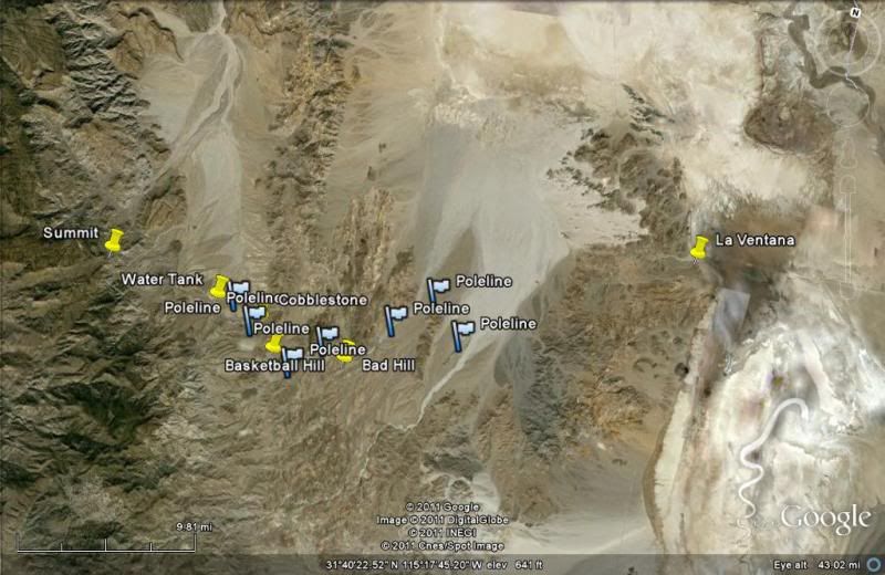
West section:
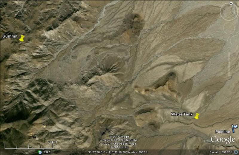
Moving East:
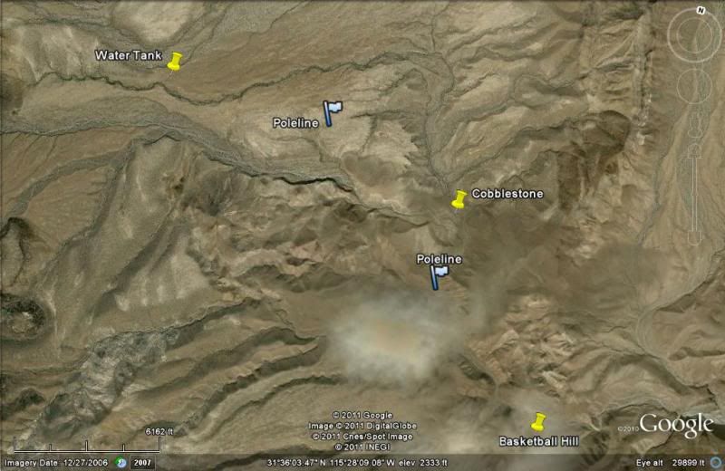
Center:
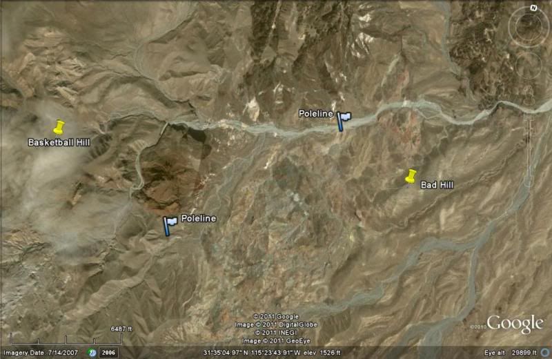
East:
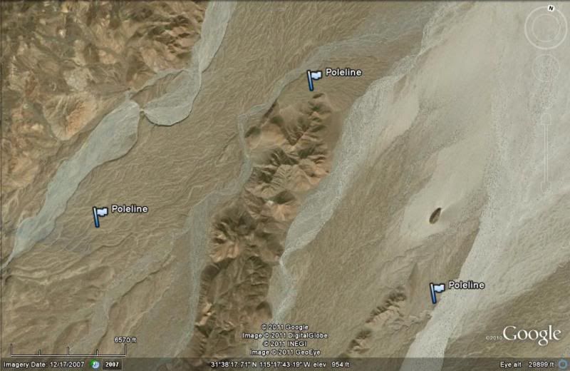
The far right flag above is where the Pole Line Road meets Arroyo Grande.
|
|
|
Ken Cooke
Elite Nomad
Posts: 8971
Registered: 2-9-2004
Location: Riverside, CA
Member Is Offline
Mood: Pole Line Road postponed due to injury
|
|
What cannot be shown in detail are all of the rocky dry stream beds that must be negotiated.
|
|
|
TMW
Select Nomad
Posts: 10659
Registered: 9-1-2003
Location: Bakersfield, CA
Member Is Offline
|
|
BJ and I were thinking of doing it in Nov when pre-running for the 1000 starts. Start over the Summit and end in Arroyo Grande at the Diaz grave.
|
|
|
David K
Honored Nomad
Posts: 65563
Registered: 8-30-2002
Location: San Diego County
Member Is Offline
Mood: Have Baja Fever
|
|
That's the positive attitude Tom!
|
|
|
| Pages:
1
2 |


