| Pages:
1
2
3
4 |
David K
Honored Nomad

Posts: 64479
Registered: 8-30-2002
Location: San Diego County
Member Is Offline
Mood: Have Baja Fever
|
|
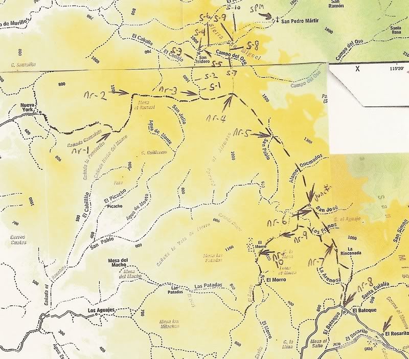
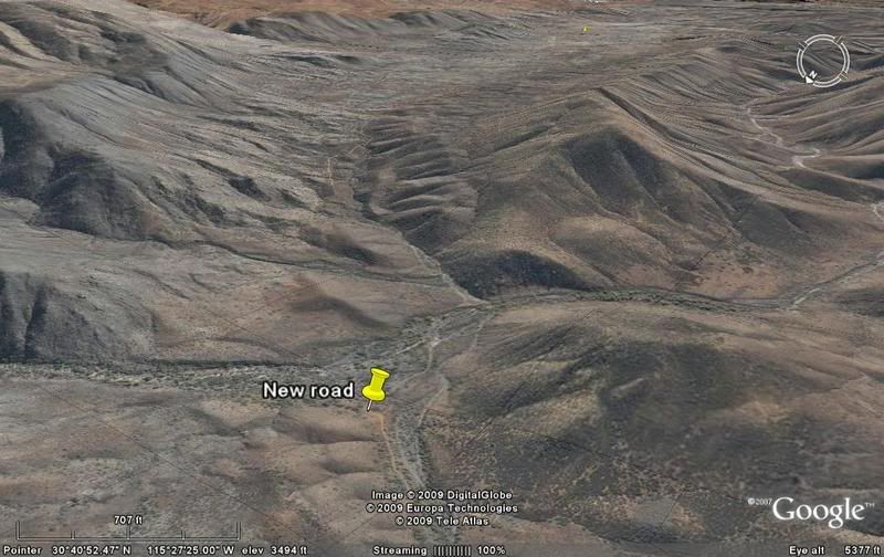
NEW ROAD in the Sierra San Pedro Martir foothills
May not be super new... but is yet to show on any maps. It looks to be a graded road that extends beyond the road shown going to and ending at Rancho
Nueva York (northeast of San Quintin)...
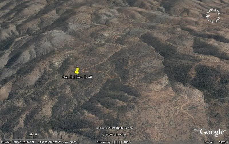
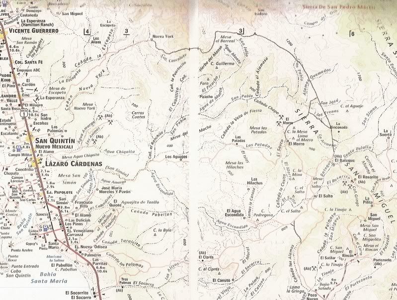
Continues up to the high country and permits better access to San Isidoro and the trail to Mision San Pedro Martir, in 2 places.
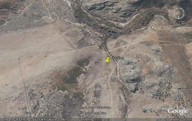
Then continues southeast along the base of the Sierra San Miguel, which is really part of the entire San Pedro Martir range, to meet the road coming
up from El Socorro or Los Martires to El Rosarito and El Suerte.
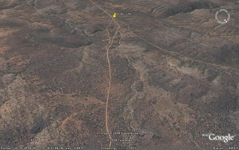
A new cut across road goes to the El Morro mine area, as well.
In a seperate post on the Baja Nomad Baja Hiking and Backpacking forum, I will show the San Isidoro/ Mision San Pedro Martir trail... as viewed from
Google Earth satellite
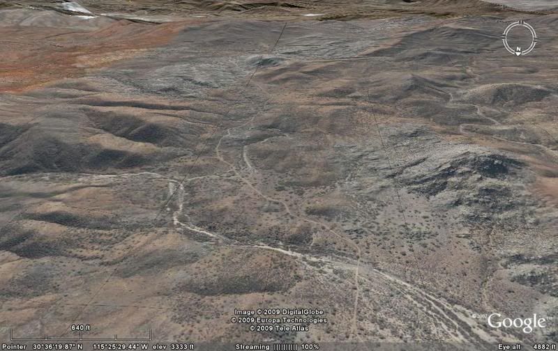
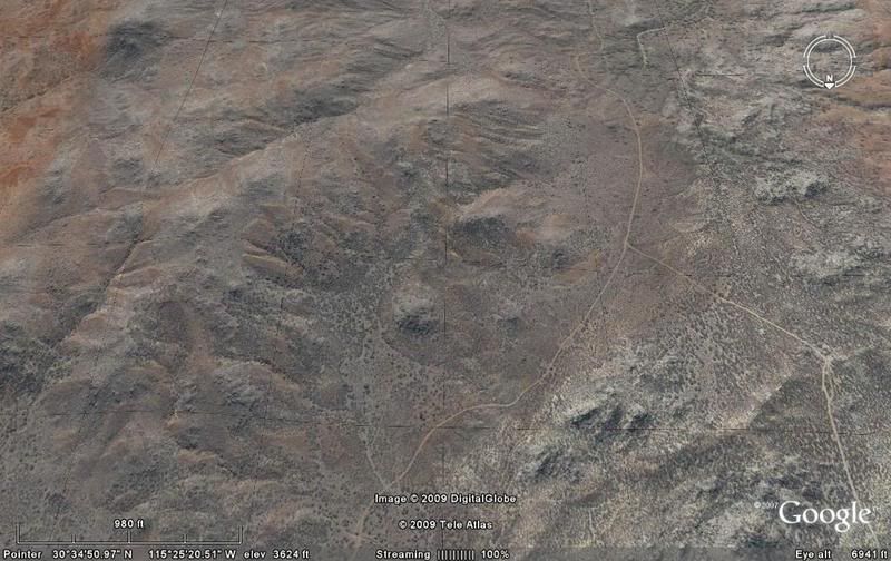
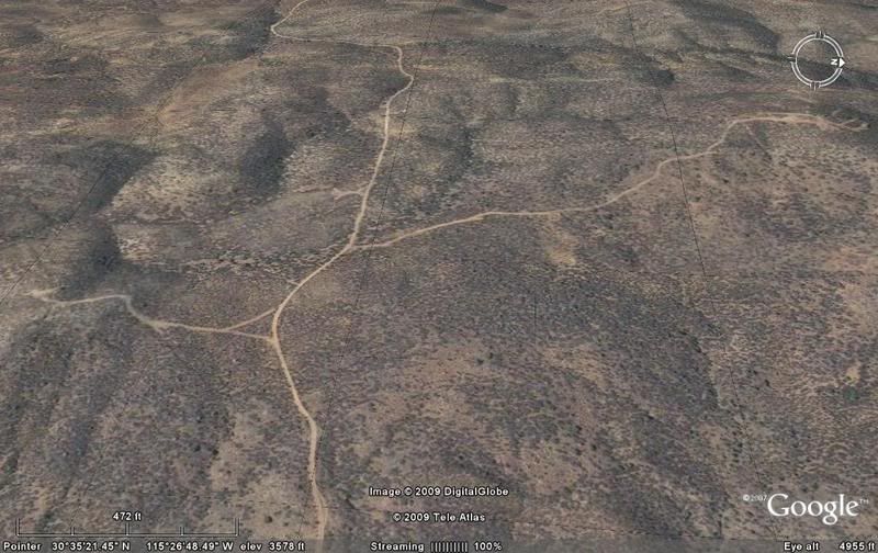
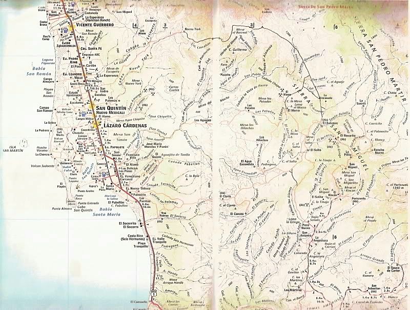
Here is the overall area (Meling Ranch and Observatory road near top):
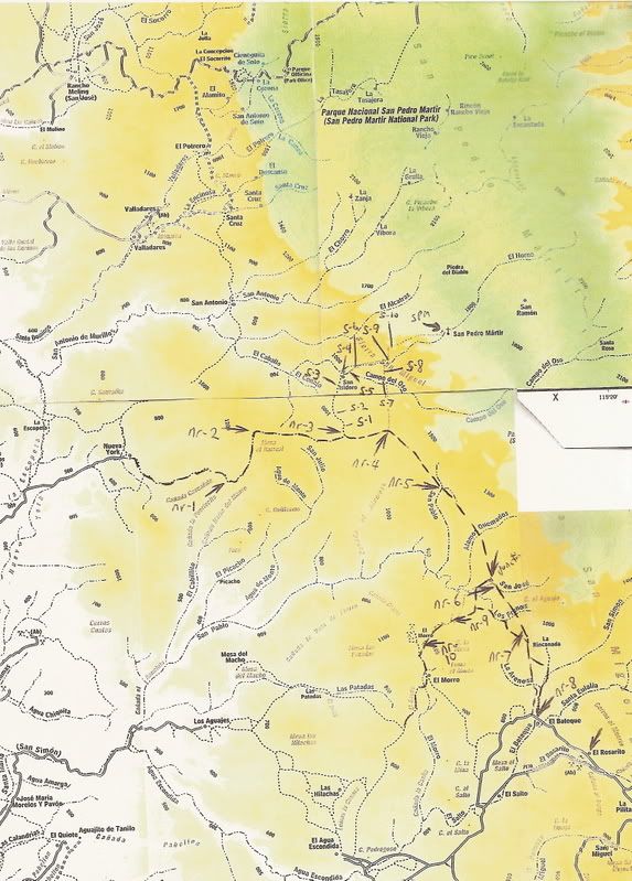
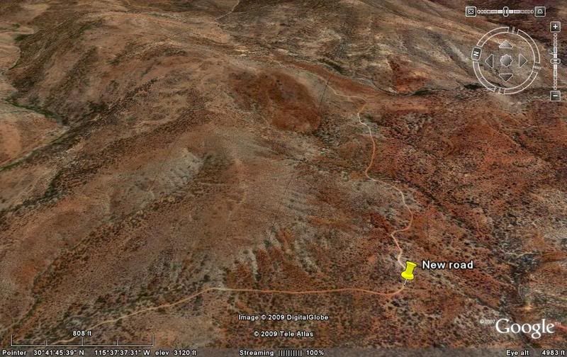
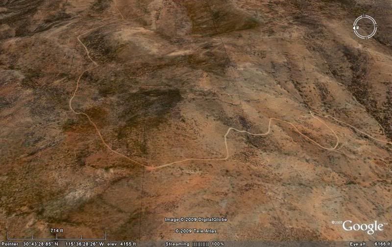
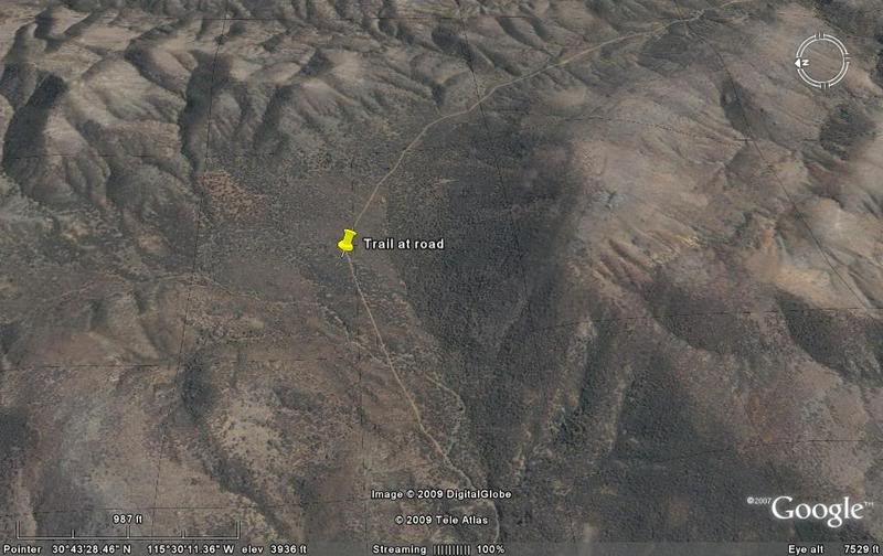
Here is the new road area... the arrows show where I have saved a satellite image, below.
Images facing direction of travel...
nr-1)
nr-2)
nr-3) Trail to San Isidoro to north here:
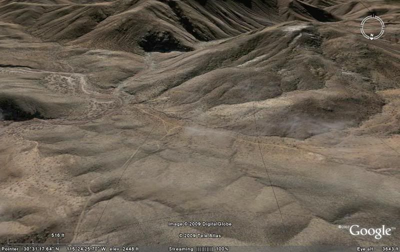
nr-4) Second trail north to SPM trail, passes mine tunnel:
nr-5)
Junction with road to El Morro)
nr-6)
nr-7)
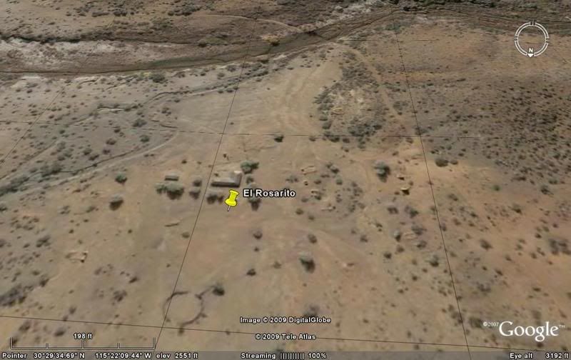
nr-8)
El Rosarito)
nr-9 on El Morro road) Two mine driveways, left and right:
nr-10) El Morro junction
Map again:
I believe the Baja 1000 ran this way at least once to get south without using highways... reaches Hwy. 1 east of El Rosario at Los Martires/ Arenoso.
[Edited on 3-5-2009 by David K]
|
|
|
Mexitron
Ultra Nomad
Posts: 3397
Registered: 9-21-2003
Location: Fort Worth, Texas
Member Is Offline
Mood: Happy!
|
|
Interesting--you DO have alot of time on your hands!
I vaguely recollect this road being there in 2004 and thinking the access to the mission might have been easier from there--it might be on my old topo
map. I think there was also an old road going into Rancho San Antonio but it was pretty well washed out. How does this road connect up with Rancho
La Suerte? Maybe you have to head south to the El Salto or Rosarito and then go back north to La Suerte.
Sorry for the editing --I keep getting R. San Antonio and San Isidoro mixed up...see what happens when you stay away too long!
[Edited on 3-5-2009 by Mexitron]
[Edited on 3-5-2009 by Mexitron]
|
|
|
David K
Honored Nomad
Posts: 64479
Registered: 8-30-2002
Location: San Diego County
Member Is Offline
Mood: Have Baja Fever
|
|
El Suerte is just off that map, east of El Rosarito.
See the new post about the SPM Mission trail, on the Nomad Hiking and Backpacking forum... I have a question for you about your trip.
Here is the San Pedro Martir trail post: http://forums.bajanomad.com/viewthread.php?tid=37434
[Edited on 3-6-2009 by David K]
|
|
|
Mexitron
Ultra Nomad
Posts: 3397
Registered: 9-21-2003
Location: Fort Worth, Texas
Member Is Offline
Mood: Happy!
|
|
Rats, can't find the topo...looks like great exploring though! That country, especially south, seems to always have new roads cut into it by the
Yucca harvesters. In the 80s there were new roads put in by the government for ranching too, I think.
|
|
|
David K
Honored Nomad
Posts: 64479
Registered: 8-30-2002
Location: San Diego County
Member Is Offline
Mood: Have Baja Fever
|
|
Check u2u and see my SPM mission trail from space post.
Thanks!
By the way, the old Atlas shows only a trail from Nueva York to San Isidoro, as did the 2003 Almanac.
Wonder if the 2009 Almanac has these new roads?
|
|
|
David K
Honored Nomad
Posts: 64479
Registered: 8-30-2002
Location: San Diego County
Member Is Offline
Mood: Have Baja Fever
|
|
Has anyone been on this new mountain road?
|
|
|
Barry A.
Select Nomad
Posts: 10007
Registered: 11-30-2003
Location: Redding, Northern CA
Member Is Offline
Mood: optimistic
|
|
Excellent work, David. I love this stuff!!!
Barry
|
|
|
cristobal
Nomad
Posts: 194
Registered: 12-16-2003
Location: california
Member Is Offline
|
|
These roads are my kind of baja ... Thanks, David ...
|
|
|
David K
Honored Nomad
Posts: 64479
Registered: 8-30-2002
Location: San Diego County
Member Is Offline
Mood: Have Baja Fever
|
|
10-4 on that! Good to hear from you Cristobal! Please post any trip reports... You like going to the high country between San Ignacio and Mulege too,
right?
|
|
|
Mexitron
Ultra Nomad
Posts: 3397
Registered: 9-21-2003
Location: Fort Worth, Texas
Member Is Offline
Mood: Happy!
|
|
It rains hard in those areas---good chance its been compromised after the latest rains....
|
|
|
David K
Honored Nomad
Posts: 64479
Registered: 8-30-2002
Location: San Diego County
Member Is Offline
Mood: Have Baja Fever
|
|
Yah, in the summer I would like to drive it... a huge new to explore part of Baja!
|
|
|
Mexitron
Ultra Nomad
Posts: 3397
Registered: 9-21-2003
Location: Fort Worth, Texas
Member Is Offline
Mood: Happy!
|
|
I haven't been in that area since the mission trip...Its very interesting botanically---you've got the SPM Juniper Oak Woodlands meeting the last
vestiges of foothill chapparal and Calif. coastal scrub meeting Blue Palm canyons meeting the beginnings of the Central Desert vegetation. of course
its just plain fun exploring too. We're trying for a SPM trip in June...don't know if we'll have time or means to make a second leg further south but
I'm getting giddy to explore that area again...maybe even hike up Arroyo Grande this time---with all the rain it could be verdant.
|
|
|
ELINVESTIG8R
Select Nomad
Posts: 15882
Registered: 11-20-2007
Location: Southern California
Member Is Offline
|
|
David K. When it comes to La Baja I don't think anyone can hold a candle to you! Keep it coming Brother!
David
|
|
|
56MM#
Junior Nomad
Posts: 59
Registered: 2-3-2010
Member Is Offline
|
|
I did part of that route on May 25, 2001, specifically the area between NR1 and NR2 on Davids satellite images. This route is also depicted as a
dotted line that runs through Canada Cascalote on page N-16 of the mid-90s version of the Baja Almanac (orange cover). At the time, that was the
extent of the road, or rather trail. Am sad to see yet another road cut into what was until recently a very remote and pristine area of northern Baja
California. For what its worth, heres my trip report:
I saw this road in the Baja Almanac and was fascinated that there might be a different route to Mision San Pedro Martir. After hours of staring at
the map and imagining the possibilities, I convinced a friend to spend Memorial Day weekend poking around the backcountry.
Vehicle was a 1995 Toyota 4-Runner with 32-inch BFG Mud Terrains, rear locking differential and a mild suspension lift (thicker springs and torsion
bars). As it turned out, it required every bit of my trucks capability to make it through.
Spend the night before camped in the hills east of San Quintin, clear of civilization and out of sight of Highway 1. We started east shortly after
sunrise the next morning. Except for a three mile stretch in the middle which required 4WD, the road to Nueva York was easily passable by a 2WD
pickup truck. Along the road, we came upon a rattlesnake soaking up some sun.
Nueva York was either a part time or abandoned rancho. The few structures we saw were made of poles, sticks and palm fronds, good for keeping out the
rain but offering little protection from wind or cold. There were several cattle hides stretched out on wooden racks. No persons were present.
There were several short side roads around Nueva York. After taking each one and discovering that none went more than a mile from the rancho, we were
ready to head back. As I looked east and squinted, I saw what looked like a graded road cut into a hillside. Looking through binoculars confirmed
what I saw, however we could see no road that led from the rancho to the graded road. The only way to this road was through a flat and somewhat moist
field with some medium-size rocks that we had to dodge. This would be our first of several areas we would have to cross to get to the continuation of
the trail.
The road cut into the hillside was fairly rocky but passable. After maybe two miles, the road disappeared altogether and became a series of
intermittent trails barely passable to a vehicle. There were so many areas where we had to stop and walk as far as 1/8 of a mile to find where the
trail started up again. We spend more time out of the vehicle looking for the trail than moving forward in my truck. There were stretches where I
could have used a chain saw. A skilled spotter was a must as there were numerous obstacles where it took the exact right tire placement to get
through. Each time we got past a particularly challenging obstacle, I would wonder if we would make it back out when the time came.
After several hours of rock crawling, tilted trails, overgrown vegetation and stream crossings with high banks, all of which resulted in bottoming out
and tail dragging, we reached the end of the trail. Here are the coordinates (degrees/minutes/seconds) and altitude where the passable portion of the
trail ended: N 32 42 04.2 W 115 36 51.6 3300 feet MSL.
It was clear that this was the end. The area was a very small box canyon with 5 to 10 foot walls. There was a circle of rocks and firepit that had
probably not been used for years. I also noted a respectable amount of faded beer cans. There was no way even a motorcycle could continue. The only
ways forward from here are by foot or mule. Either way, I think it would take a skilled trail finder and capable rock climber to reach the mission.
Getting out the way we came in was just as challenging. Things looked totally different from the opposite angles. Obstacles that we cleared going
down were much harder going up, especially out of streams.
We did not get back to San Quintin until an hour after dark. It took all the daylight a late-May day had to offer (over 13 hours I believe). As
every experienced backcountry traveler knows, when the sun goes down it is very difficult to navigate. At the end of the day, my trucks sides were
pretty scratched up. Sumac bushes were the biggest culprits. But is was worth every scratch.
I think we were lucky. I would not do this route alone again. Nor would I imbibe, something that rounds out the whole Baja backcountry experience,
taking it from excellent to perfect. You are basically out there in a very remote part of the peninsula with no backup. Looking back, we probably
pushed a bit too hard with my truck. There were many obstacles that we barely got past. And the tilt of some areas could cause a lifted vehicle to
roll.
To this day, the Nueva York route, as we call it, remains one of my two favorite Baja California side trips, the other being San Juan de las Pilas.
For me, the feeling of sheer remoteness is the greatest appeal. There were no power lines or other signs of civilization, other than wheel tracks and
the occasional faded beer can. Even Baja cow pies were few and far between. To me it felt even more remote than the Maze District of Canyonlands
National Park. I have never felt so isolated in my life than I did east of Nueva York. One cannot put the feeling into words. The area is wild,
even by Baja California standards. If you are after remoteness and unspoiled scenery, then this is the place for you.
|
|
|
David K
Honored Nomad
Posts: 64479
Registered: 8-30-2002
Location: San Diego County
Member Is Offline
Mood: Have Baja Fever
|
|
Wow... THANK YOU for that story and a BIG welcome to Baja Nomad, 56mm#  
|
|
|
Mexitron
Ultra Nomad
Posts: 3397
Registered: 9-21-2003
Location: Fort Worth, Texas
Member Is Offline
Mood: Happy!
|
|
Oh man, now I really wanna go! Nice report there 56mm.
One thing about summer David--it can be blistering hot out there...not always though--if there's a good marine layer at the coast it might not be too
bad.
|
|
|
BajaGringo
Ultra Nomad
Posts: 3882
Registered: 8-24-2006
Location: La Chorera
Member Is Offline
Mood: Let's have a BBQ!
|
|
Great post 56mm and welcome to the forum...
|
|
|
56MM#
Junior Nomad
Posts: 59
Registered: 2-3-2010
Member Is Offline
|
|
My first experience in this area was driving to Meling Ranch and the observatory many years ago. Scenery begins as one starts the climb out of the
San Telmo valley. It was Spring, and the area had experienced a wetter than normal winter. The hillsides were green with yellow flowers. I imagined
that this was what the inland valleys of San Diego County looked like 100 years ago.
I think alot of Baja aficionados blow past the western slopes of the Sierra San Pedro Martir for places further south. The old rule that the real
Baja doesn't start until El Rosario drives us to do just this, and the axiom may not be completely true. IMHO, this area may be the best part of Baja
north of El Rosario.
David, thanks for finding this road. I now feel like I have to go down there. I think its doable over a four-day period: Leave San Diego Friday
morning, spend Friday night camped somewhere east of Nueva York, explore Saturday and Sunday, spend Sunday night in El Rosario, and drive home Monday.
Still have mixed feelings about this road. On one hand, the area is now accessible to vehicles, which will certainly bring more people into the area,
not usually a good thing. On the other hand, the accessibility allows me to further explore this area. My selfish side hopes that the recent rains
did some damage to the road, which will hopefully discourage visitors. So only the most determined Baja lovers will go.
When I was there nine years ago, it felt like we were some of the few gringos that had ventured into the area. Even so, we barely scratched the
surface. That feeling will draw me back.
|
|
|
David K
Honored Nomad
Posts: 64479
Registered: 8-30-2002
Location: San Diego County
Member Is Offline
Mood: Have Baja Fever
|
|
If you think it may be too wet up there... join us at Santa Ynez Saturday morning!
Here is the new Sierra road drawn onto the new Almanac:
[Edited on 2-8-2010 by David K]
|
|
|
56MM#
Junior Nomad
Posts: 59
Registered: 2-3-2010
Member Is Offline
|
|
David, thanks for the maps and the invite. One day I would like to join you all on one of your trips.
|
|
|
| Pages:
1
2
3
4 |


