| Pages:
1
2
3
4 |
David K
Honored Nomad

Posts: 64491
Registered: 8-30-2002
Location: San Diego County
Member Is Offline
Mood: Have Baja Fever
|
|
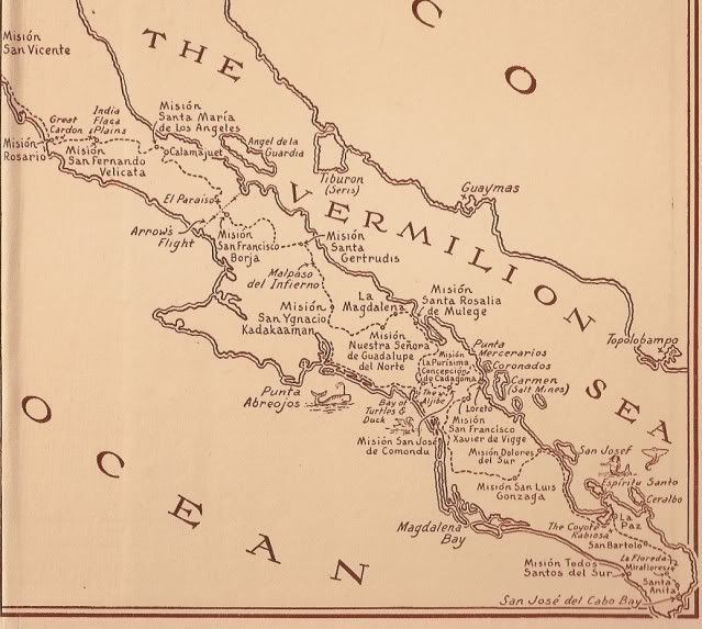
Feb. 12, 1772 on Magdalena
Here is a page from the 1772 report by Franciscan Fr. Palou on the status of the missions. Here Father Palou describes Magdalena as a potential new
location for the Mulege mission, following the floods of 1770 that destroyed the dam and farmlands there.
It reads as if nothing existed there before, since he talks about building an irrigation system. This is why I don't believe the Jesuits had built
those ruins, aqueduct or pila... those were all put in by the Dominicans after 1773... But, who can say for sure!?
|
|
|
David K
Honored Nomad
Posts: 64491
Registered: 8-30-2002
Location: San Diego County
Member Is Offline
Mood: Have Baja Fever
|
|
Harry Crosby is the premier authority on the Jesuits in California and his research is contained in the book 'Antigua California'. There is NO mention
of any Jesuit visita of Magdalena (or Rondin) that I can find.
I tend to side with Gerhard & Gulick and go with the ruins being part of a 1774 Dominican visita. I am curious why no mention of the old church
overlooking the arroyo 5 miles west at San Jose de Magdalena is mentioned by G & G. Either they did not see it or it was simply a post mission
period church (ie. from ~1879) and not the Dominican visita...?
[Edited on 8-18-2009 by David K]
|
|
|
David K
Honored Nomad
Posts: 64491
Registered: 8-30-2002
Location: San Diego County
Member Is Offline
Mood: Have Baja Fever
|
|
| Quote: | Originally posted by bajaamy
One thing I'd really like to do in the future is interview some of the elderly residents of the town (sort of "Juanita-style" from San Ignacio).
Amy |
Unfortunately, no one is still alive who can remember the year 1879... or earlier. Since it makes their town more popular and would bring in tourist
dollars, calling the old church ruins a mission visita would be of benefit. Perhaps an elder believed it was from the Dominicans and that is the story
that gets passed down. The Mexicans that settled the area arrived after the mission period had ended, after nearly all the Indians had died. There
would be nobody to tell the story of Magdalena. We have only the books written by the missionaries to find answers.
I am not sure and I have not seen anything in print that convinces me of either site being the 'main' visita of Magdalena. I do have Michael Mathes'
email address now and will see if he can shed some light on why he called the San Jose site, the visita of 1774 while others call the desert site the
visita.
Why did the padres build such a long aquaduct out to the desert site? Why not just develope the San Jose valley/ canyon area as the Mexicans have
done? There is some reason for all that building in the desert with the aquaduct and pila. That desert site was important, but as what?
The quest continues!
|
|
|
David K
Honored Nomad
Posts: 64491
Registered: 8-30-2002
Location: San Diego County
Member Is Offline
Mood: Have Baja Fever
|
|
NEW SATELLITE IMAGES SHOW THE RUINS GONE!
The ancient and mysterious stone ruins of La Magdalena (shown often on maps misnamed Santa Maria Magdalena, and not in the correct spot) have been
wiped out by the enlarged Arroyo Boca de Magdalena (as named in the Almanac).
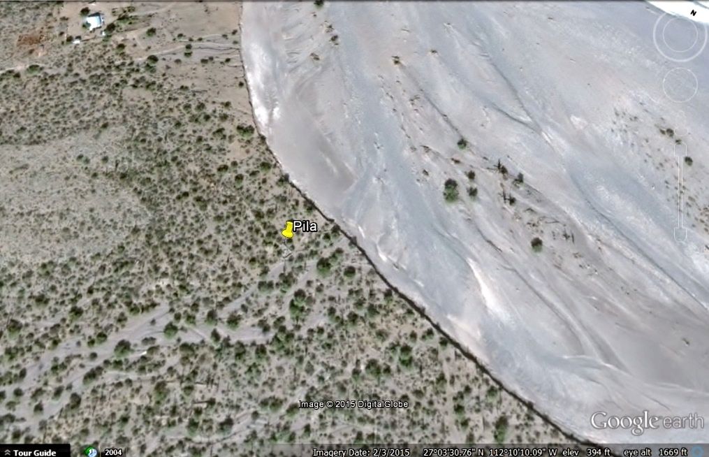
Just like what happened at Ligüí, the arroyo grew into the 1700's mission-era ruins. Perhaps some Punta Chivato/Mulegé area Nomads can get some new
photos at the pila before it too is lost for all time?
[Edited on 11-2-2021 by David K]
|
|
|
David K
Honored Nomad
Posts: 64491
Registered: 8-30-2002
Location: San Diego County
Member Is Offline
Mood: Have Baja Fever
|
|
2013 vs. 2015
4-2-13:
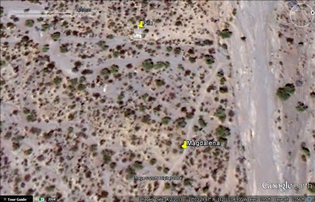
2-3-15:
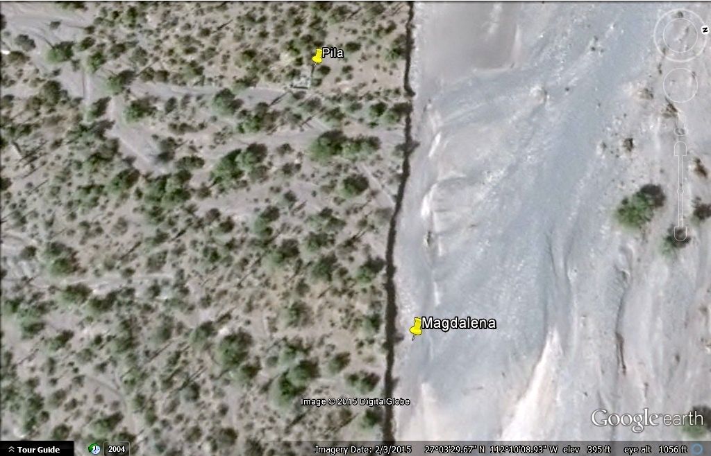
[Edited on 11-2-2021 by David K]
|
|
|
David K
Honored Nomad
Posts: 64491
Registered: 8-30-2002
Location: San Diego County
Member Is Offline
Mood: Have Baja Fever
|
|
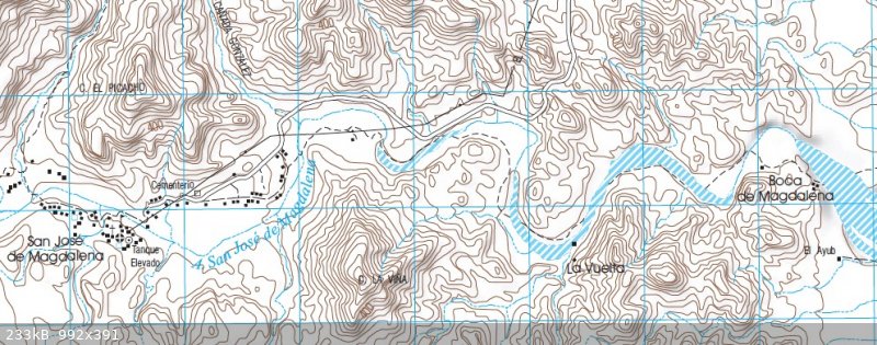
There may be other building ruins beside the pila not washed away? On Google Earth, there appears to be some structures that were not next to the
road, that we saw on July 24, 2009. Some investigating is needed. I plan to return in 2 months and will report what has survived of the mysterious
ruins from the 1700's.
|
|
|
David K
Honored Nomad
Posts: 64491
Registered: 8-30-2002
Location: San Diego County
Member Is Offline
Mood: Have Baja Fever
|
|
Magdalena visit, July 25, 2015: Much is gone, but not all!
We drive 4.8 miles from Hwy. 1, Km. 162.5, and find the pila intact but most of the stone ruins are washed away, in the riverbed, which is about 10
feet lower than the ruin site. Some wall remains are still above the riverbed, next to the new cliff.
Pila, then building ruins, and a photo showing my truck in the arroyo (close to the pila) as seen from the remains of the building complex of La
Magdalena.
Now, the few building remains, east of the pila, next to the new arroyo cliff:
Looking west, up the arroyo from the building ruins to my truck, parked close to the pila site, which is only 100 feet or so to the left of the truck:
[Edited on 10-6-2022 by David K]
|
|
|
David K
Honored Nomad
Posts: 64491
Registered: 8-30-2002
Location: San Diego County
Member Is Offline
Mood: Have Baja Fever
|
|
This historic site is only 15 miles north of Mulegé, and since it is vanishing with every flash flood, don't delay in making the short off-road trip
to it.
[Edited on 7-18-2018 by David K]
|
|
|
David K
Honored Nomad
Posts: 64491
Registered: 8-30-2002
Location: San Diego County
Member Is Offline
Mood: Have Baja Fever
|
|
'La Magdalena' on this 1933 map of trails used including El Camino Real from the novel, Journey of the Flame:
|
|
|
David K
Honored Nomad
Posts: 64491
Registered: 8-30-2002
Location: San Diego County
Member Is Offline
Mood: Have Baja Fever
|
|
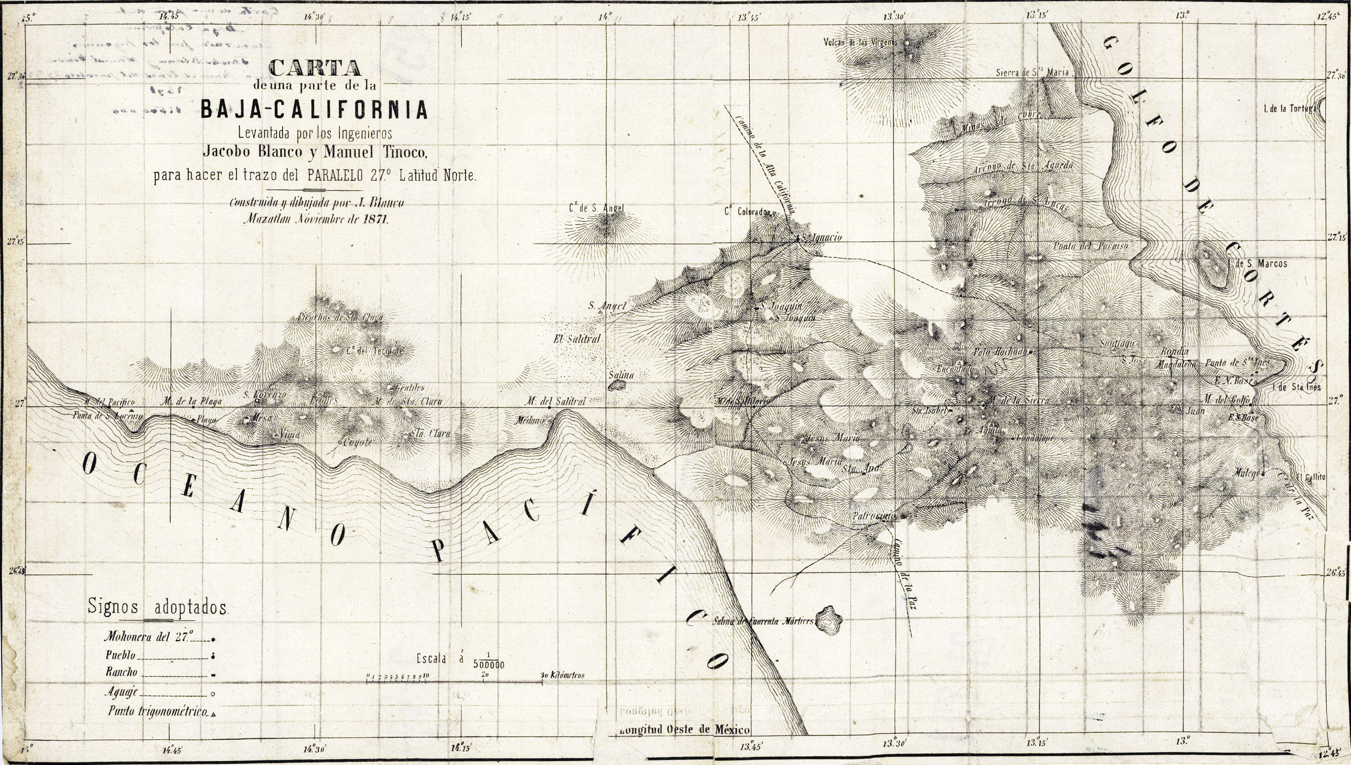
Bump for current discussion of 1871 map.
https://octopup.org/img/media/maps/baja/1871--Santa-Rosalia-...
[Edited on 11-7-2021 by David K]
|
|
|
David K
Honored Nomad
Posts: 64491
Registered: 8-30-2002
Location: San Diego County
Member Is Offline
Mood: Have Baja Fever
|
|
La Piedad was the location name for where Santa Gertrudis was founded.
Dolores del Norte was the early 'proposed' mission name for what became Mission Santa Gertrudis.
Santa María Magdalena was ANOTHER proposed mission beyond San Ignacio and on the Jesuit map (of missions and proposed or started missions) is placed
past Santa Gertrudis (Dolores del Norte), towards Bahía de los Angeles. That is why Choral Pepper came to the belief that the mystery walls, dam,
date palm they discovered near Bahía las Animas may have been that aborted mission project? It's bell ended up at the nearest mission to the south.
A third proposed mission shown in the same Jesuit books and maps, was San Juan Bautista, west of San Ignacio. This became locally known as the Lost
Santa Clara Mission (north of Punta Abreojos).
I do have all the 'lost' or 'non-missions' detailed in my book, pages 184-191.
|
|
|
David K
Honored Nomad
Posts: 64491
Registered: 8-30-2002
Location: San Diego County
Member Is Offline
Mood: Have Baja Fever
|
|
I am not disagreeing with Barco... as he said, in the end, of the three proposed missions, only Dolores del Norte was established, under the name
Santa Gertrudis.
The other two never really existed beyond lists in books and maps made to promote the Jesuit's success in hopes of gaining more financial assistance
from wealthy benefactors. The poverty of California in the 1700s was great. Even the silver mines or pearl fisheries were of little success, at least
to the Jesuits.
The thread was made to help clear up the use of the name Santa María Magdalena as applied in error, near Mulegé. The 1871 map was helpful in
distinctly showing 'Magdalena' and 'Rondin' along the same arroyo (San José on old maps and Boca de Magdalena on new maps).
We can't tell if Rondin was by the cliff with the aqueduct (later a village called Boca de Magdalena) or is where today's town of San José de
Magdalena is located.
The map: https://octopup.org/img/media/maps/baja/1871--Santa-Rosalia-...
|
|
|
David K
Honored Nomad
Posts: 64491
Registered: 8-30-2002
Location: San Diego County
Member Is Offline
Mood: Have Baja Fever
|
|
They are only a couple miles apart.
Nothing between other than the ruined old church that some thought was a Dominican visita.
Curious:
Why do you spell Dolores differently?
[Edited on 11-7-2021 by David K]
|
|
|
David K
Honored Nomad
Posts: 64491
Registered: 8-30-2002
Location: San Diego County
Member Is Offline
Mood: Have Baja Fever
|
|
Quote: Originally posted by Lance S.  | Nice little description of Magdalena from Itenerarios y Derroteros 1856.
"You arrive at the ruined chapel of La Magdalena, of which there are walls and sowing lands, which were cultivated and watered by means of an
aqueduct, cut into the slope of the hill, that receives water from the Canada del Rondin in which there is a small ranch."
|
That is great! So, Rondin is the canyon separating the valley of San José de Magdalena and the desert where La Magdalena ruins were (at the end of
the canal)?
|
|
|
4x4abc
Ultra Nomad
Posts: 4167
Registered: 4-24-2009
Location: La Paz, BCS
Member Is Online
Mood: happy - always
|
|
the elevation profile indicates water
cool find!
Harald Pietschmann
|
|
|
4x4abc
Ultra Nomad
Posts: 4167
Registered: 4-24-2009
Location: La Paz, BCS
Member Is Online
Mood: happy - always
|
|
so - mystery solved
Rancho La Vuelta = Rondin
Rondin is just an old word for Vuelta (curve)
the mention of the little ranch is good
because the canyon behind La Vuelta is called Cañada el Ranchito

Harald Pietschmann
|
|
|
David K
Honored Nomad
Posts: 64491
Registered: 8-30-2002
Location: San Diego County
Member Is Offline
Mood: Have Baja Fever
|
|
Arthur North camped by the La Magdalena site, not the San José de M. chapel, as far as I can recall. That is how the whole error with calling La
Magdalena as 'Santa María Magdalena' (the proposed mission north of San Ignacio) began. Other mission books, Mexican maps, and the AAA map happily
made it "Mission Santa María Magdalena".
The aqueduct and canal ended at the pila of La Magdalena. On older Google Earth imagery, you can see the route passing by the blue ranch house to the
rectangular pila. Perhaps there was more branches or more pilas we cannot see any longer?
|
|
|
4x4abc
Ultra Nomad
Posts: 4167
Registered: 4-24-2009
Location: La Paz, BCS
Member Is Online
Mood: happy - always
|
|
I personally don't like the location
doesn't fit what the padres usually chose
my favorite is this one:
27° 3'29.61"N, 112°13'42.86"W
the one David is promoting I find extremely unlikely
it is in a flood area and has no infrastructure around it
Harald Pietschmann
|
|
|
David K
Honored Nomad
Posts: 64491
Registered: 8-30-2002
Location: San Diego County
Member Is Offline
Mood: Have Baja Fever
|
|
I agree that it is a crazy place for a farm, out in the desert like that.
I wish there was more written about it... The fact remains there was cut stone block walls and adobe remains out there plus the pila. I am so glad I
got to see it before the 2014 flood took it out!
|
|
|
4x4abc
Ultra Nomad
Posts: 4167
Registered: 4-24-2009
Location: La Paz, BCS
Member Is Online
Mood: happy - always
|
|
the other structures are still there
27° 3'26.02"N, 112°10'11.33"W
Harald Pietschmann
|
|
|
| Pages:
1
2
3
4 |


