| Pages:
1
2
3 |
David K
Honored Nomad

Posts: 64476
Registered: 8-30-2002
Location: San Diego County
Member Is Offline
Mood: Have Baja Fever
|
|
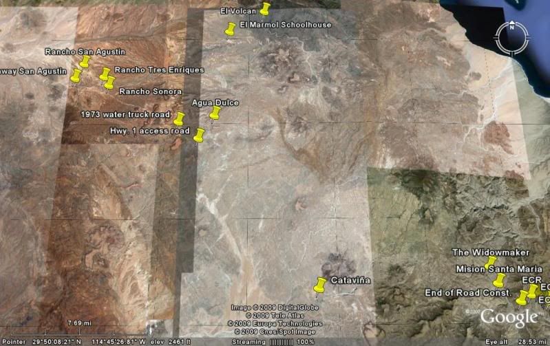
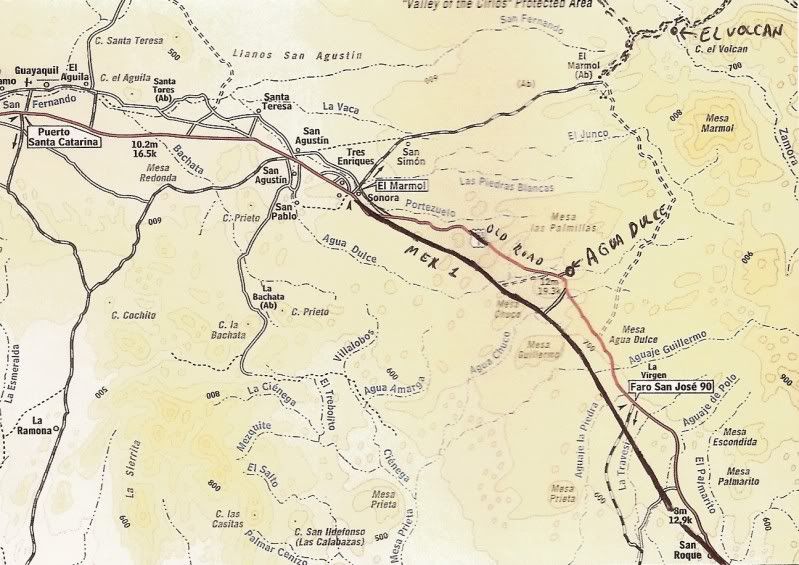
Agua Dulce Spring on the Camino Real
Agua Dulce (Sweet Water) was an important spring along the Camino Real between Mision Santa Maria and Mision San Fernando. During the construction of
Highway One, in 1973, road crews bulldozed the spring for easy access to water trucks as water was needed for highway construction. The spring is 2.0
miles from Highway One over a fair road.
A good access road was found by Neal Johns after I had used the original construction access road (badly washed out) a couple years ago... that
original road is at Km. 157-158. The improved, shorter access is at Km. 160-161, just south of a small 'rancho on the west side of Mex. 1. The road
goes east (left) from the highway and travels 1.4 miles to where it intersects with the original dirt road to La Paz (pre-1973).
The Baja Almanac shows Arroyo Agua Dulce (Map 16, D-5) crossing the highway... however, the highway is wrong... that is actually the old main road
location 1.4 miles east of the actual highway location. The spring is 1/4 mi. up the arroyo from the (incorrect) highway crossing, on the map.
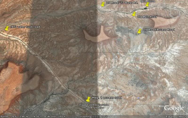
In this photo, my truck is at the junction of the access road and the old main road (the original Baja/Mexican 1000 course), 1.4 mi. from Mex. 1...

AGUA DULCE : 29°52.97', 114°49.38'

Elizabeth at Agua Dulce... Turn north from Hwy. 1 between
Km. 160-161 (29°51.56', 114°50.35'). Go 1.4 mi. to old Baja main road
(previous photo), turn left for 0.3 mi. then right 0.3 more. Hike into gully.

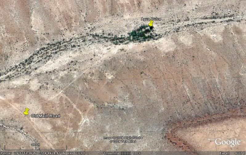
A lone blue palm grows from the gully containing the large spring. Located along the El Camino Real, Agua Dulce was a vital water source for early
travels. GPS at the water's edge is N29°52.97'/ W114°49.38' (NAD27).
2003:

Agua Dulce, from the north side of the historic spring. Neal Johns photo.
2002:

I came back for look in 2002. We camped here in 1966 during our big trip to the tip and came by again in 1973 when the highway was under construction.
Agua Dulce from space:
|
|
|
David K
Honored Nomad
Posts: 64476
Registered: 8-30-2002
Location: San Diego County
Member Is Offline
Mood: Have Baja Fever
|
|
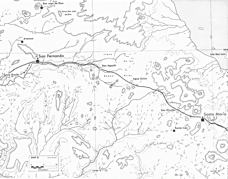
Agua Dulce is on El Camino Real... the mission road from Loreto to San Francisco, Alta California.
|
|
|
Mexitron
Ultra Nomad
Posts: 3397
Registered: 9-21-2003
Location: Fort Worth, Texas
Member Is Offline
Mood: Happy!
|
|
Been there--cool to see a place that was so vital to travelers over Baja's long history. Just want to plant another Blue Palm to give that lone one
company... 
|
|
|
David K
Honored Nomad
Posts: 64476
Registered: 8-30-2002
Location: San Diego County
Member Is Offline
Mood: Have Baja Fever
|
|
| Quote: | Originally posted by Mexitron
Been there--cool to see a place that was so vital to travelers over Baja's long history. Just want to plant another Blue Palm to give that lone one
company... |
That's a great idea! Nomads? Project: Agua Dulce Palma Azul Dos.
Neal and Marian Johns camped there and took sunrise photos: http://vivabaja.com/neal2
|
|
|
Bob H
Elite Nomad
Posts: 5867
Registered: 8-19-2003
Location: San Diego
Member Is Offline
|
|
That would be a very cool Presidents Day Weekend run David! Or, do you think that's too far away for a three day weekend?
Bob H
[Edited on 5-22-2009 by Bob H]
|
|
|
David K
Honored Nomad
Posts: 64476
Registered: 8-30-2002
Location: San Diego County
Member Is Offline
Mood: Have Baja Fever
|
|
That alone is not enough, after such a drive. However, it is very near El Marmol and El Volcan... and that would make it more interesting... Just
imagine being at El Volcan when the monthly geyser erupts??? Alas, the odds are pretty slim we would be lucky enough to be there, in the daylight to
see the rare cold water geyser erupt! February would be very cold there, too... Keep the ideas flowing Bob!
See: http://vivabaja.com/marmol
|
|
|
Mexitron
Ultra Nomad
Posts: 3397
Registered: 9-21-2003
Location: Fort Worth, Texas
Member Is Offline
Mood: Happy!
|
|
I was just perusing the road to El Volcan and beyond and the road looks like its in good shape...? I was there around 8 years ago and there was a
huge washout--has it been fixed? Or is it just that the old roads stick around for a long time...there is some interesting red rock by the end of
that road (which apparently was a mine) and it wouldn't have to go much farther to cut across to the Gulf. Looks like some interesting country out
there.
|
|
|
David K
Honored Nomad
Posts: 64476
Registered: 8-30-2002
Location: San Diego County
Member Is Offline
Mood: Have Baja Fever
|
|
| Quote: | Originally posted by Mexitron
I was just perusing the road to El Volcan and beyond and the road looks like its in good shape...? I was there around 8 years ago and there was a
huge washout--has it been fixed? Or is it just that the old roads stick around for a long time...there is some interesting red rock by the end of
that road (which apparently was a mine) and it wouldn't have to go much farther to cut across to the Gulf. Looks like some interesting country out
there. |
See posts by ELINVESTI8 (David) with photos of the La Olividada mine, at the end of the road past El Volcan... He traveled out there with Soni
Espinoza's family... They had to walk the final part.
|
|
|
David K
Honored Nomad
Posts: 64476
Registered: 8-30-2002
Location: San Diego County
Member Is Offline
Mood: Have Baja Fever
|
|
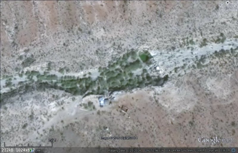
I heard from someone that a rancho was established at Agua Dulce spring and the area may be fenced off or the road gated.... ?
Anyone have new information on the historic spring?
|
|
|
TMW
Select Nomad
Posts: 10659
Registered: 9-1-2003
Location: Bakersfield, CA
Member Is Offline
|
|
David on Google Earth you can see the ranch at the water site. The GE image is dated 1-25-14.
|
|
|
David K
Honored Nomad
Posts: 64476
Registered: 8-30-2002
Location: San Diego County
Member Is Offline
Mood: Have Baja Fever
|
|
Quote: Originally posted by TMW  | | David on Google Earth you can see the ranch at the water site. The GE image is dated 1-25-14. |
Thanks Tom... wow Google Earth is sure improving on newer images of Baja!
|
|
|
David K
Honored Nomad
Posts: 64476
Registered: 8-30-2002
Location: San Diego County
Member Is Offline
Mood: Have Baja Fever
|
|
2003 Baja Almanac with corrected highway location:
EL CAMINO REAL MAP:
[Edited on 7-4-2015 by David K]
|
|
|
David K
Honored Nomad
Posts: 64476
Registered: 8-30-2002
Location: San Diego County
Member Is Offline
Mood: Have Baja Fever
|
|
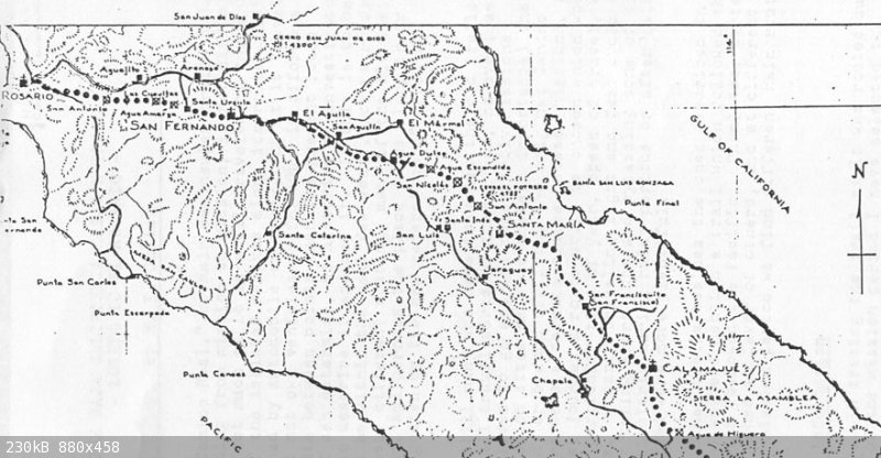
Here is the El Camino Real map made by Howard Gulick in 1954 showing Agua Dulce and the auto roads of the time. The Camino Real is indicated by dashes
where the road is visible and by dots where the route is fairly certain, but not road work is seen. The Camino Real west of Agua Dulce to El Aguila is
shown just south of the auto road of 1954-1973... and that is where Highway One was built.
|
|
|
Neal Johns
Super Nomad
Posts: 1687
Registered: 10-31-2002
Location: Lytle Creek, CA
Member Is Offline
Mood: In love!
|
|
David, that was me that told you a ranch was there now. Gated with nasty signs saying Keep Out. Horses visible. I did not make contact with the
people. Was going to show it to Art.
Neal
My motto:
Never let a Dragon pass by without pulling its tail!
|
|
|
David K
Honored Nomad
Posts: 64476
Registered: 8-30-2002
Location: San Diego County
Member Is Offline
Mood: Have Baja Fever
|
|
| Quote: Originally posted by Neal Johns | David, that was me that told you a ranch was there now. Gated with nasty signs saying Keep Out. Horses visible. I did not make contact with the
people. Was going to show it to Art.
Neal |
Then, as with the disappearing missions, our photos have preserved another historic site no longer seen by the public. Thanks Neal.
|
|
|
TMW
Select Nomad
Posts: 10659
Registered: 9-1-2003
Location: Bakersfield, CA
Member Is Offline
|
|
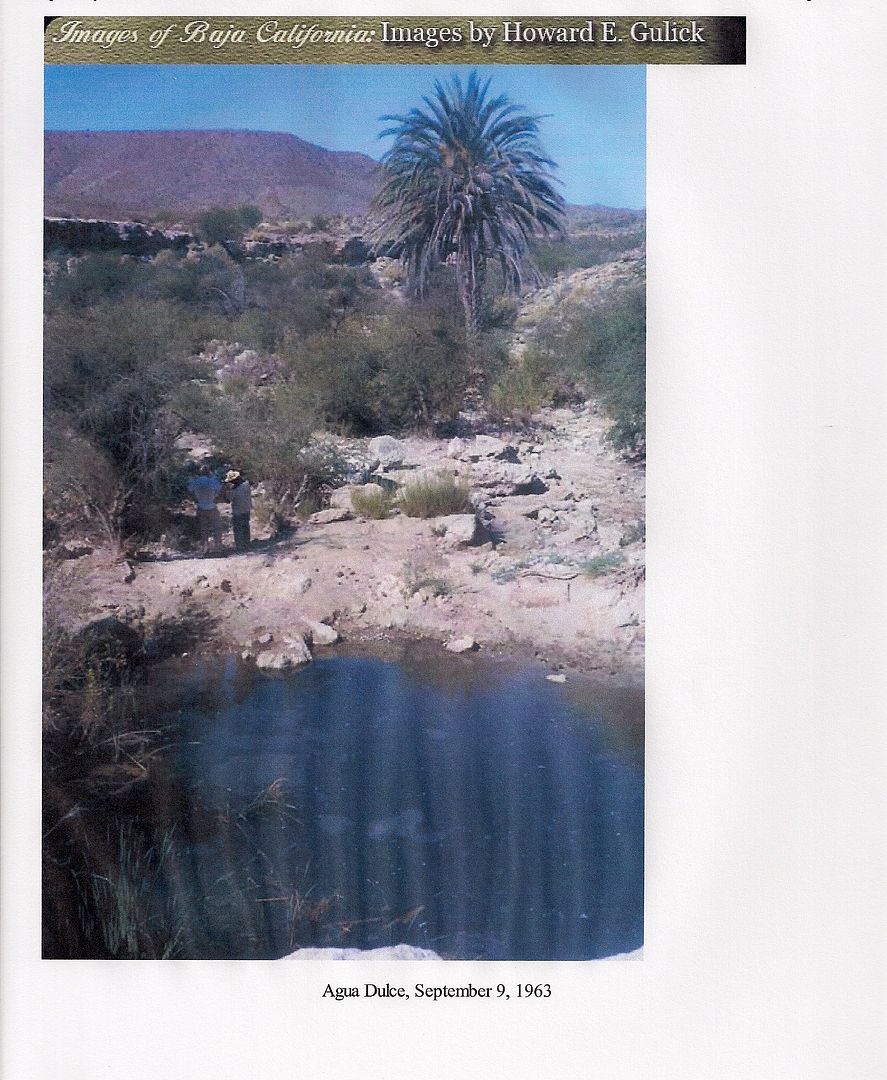
As it once was in 1963
|
|
|
rts551
Elite Nomad
Posts: 6699
Registered: 9-5-2003
Member Is Offline
|
|
You can always open the gate, after all the road was there for a long time.
|
|
|
David K
Honored Nomad
Posts: 64476
Registered: 8-30-2002
Location: San Diego County
Member Is Offline
Mood: Have Baja Fever
|
|
See Neal's post above.
The old main trans-peninsular road passes by, 0.3 mile west of the spring, which was reached by a 0.3 mile driveway.
Now a ranch is there.
Perhaps if Baja Bucko or others on muleback, was riding on the Camino Real, coming up from the south, they could reach the spring, but need the
rancher to let them out on the other side, at the old main road?
|
|
|
rts551
Elite Nomad
Posts: 6699
Registered: 9-5-2003
Member Is Offline
|
|
| Quote: Originally posted by David K | See Neal's post above.
The old main trans-peninsular road passes by, 0.3 mile west of the spring, which was reached by a 0.3 mile driveway.
Now a ranch is there.
Perhaps if Baja Bucko or others on muleback, was riding on the Camino Real, coming up from the south, they could reach the spring, but need the
rancher to let them out on the other side, at the old main road? |
You have experience in dealing with gates. enough said.
|
|
|
David K
Honored Nomad
Posts: 64476
Registered: 8-30-2002
Location: San Diego County
Member Is Offline
Mood: Have Baja Fever
|
|
I do? You have me confused with someone else, again...
|
|
|
| Pages:
1
2
3 |


