| Pages:
1
2 |
David K
Honored Nomad

Posts: 64490
Registered: 8-30-2002
Location: San Diego County
Member Is Offline
Mood: Have Baja Fever
|
|
PART 4: A Guide to the Missions & Visitas
Parts 1 & 2 showed you the 27 Spanish missions in Baja California, including multiple sites for some, along with some brief data on each mission.
Part 3 showed you several mission visiting stations ('visitas') that were, in every way, the same as a mission, but without a resident priest.
All three parts begin here: http://www.vivabaja.com/missions1/
NEW (9-23-09) WEB PAGE (still U.C.) for missions viewed from space: http://vivabaja.com/missions4
Now, for the mission locator or guide... I have maked each site on Google Earth to help see the general area around the mission and will provide a GPS
waypoint (WGS 84 in the degrees, minutes, seconds format, as used by Google Earth).
Before making a web page, I will test the satellite images here to see how well it appears after resizing for Nomad or web pages... I will be adding
some each day, so come back again and check the page! Road directions will also be included in the near future...
Satellite images are all oriented with north at the top, unless otherwise noted.
From North to South...
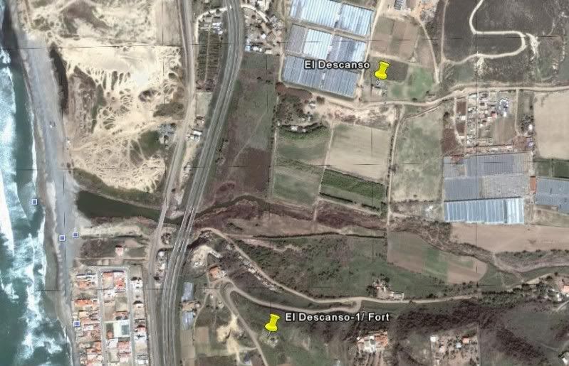
EL DESCANSO 32º12'19.62" 116º54'19.24" Located behind a church that can be seen from the Ensenada toll road. An exit just north once was signed for
the mission, but has been renamed 'Rancho Descanso'. Access from the free road along the lagoon/ arroyo, under the toll road bridge (south of the
Cantamar sand dunes). The original site (1817-1830) and fort location (Descanso-1/Fort) is to the south of the arroyo, on the hill: 32º11'59.40"
116º54'30.00"
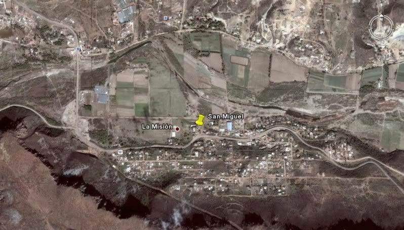
SAN MIGUEL 32º05'39.10" 116º51'15.03" Located right on the free road in La Mision, next to a school on the north side of the road.
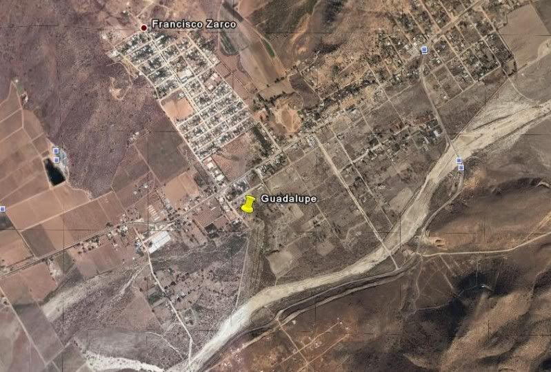
GUADALUPE 32º05'30.50" 116º34'30.50" Located on a dirt street off the entrance paved road going through Guadalupe (Francisco Zarco) from Highway 3.
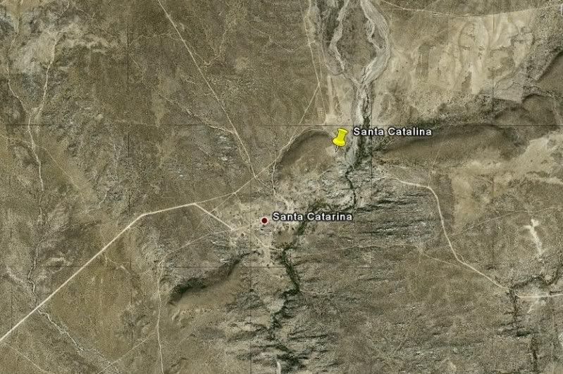
SANTA CATALINA 31º39'38.10" 115º49'16.00" Located on a hilltop overlooking a cemetery on the far side of the community of Santa Catarina, east of
Ejido Independencia off Hwy. 3.
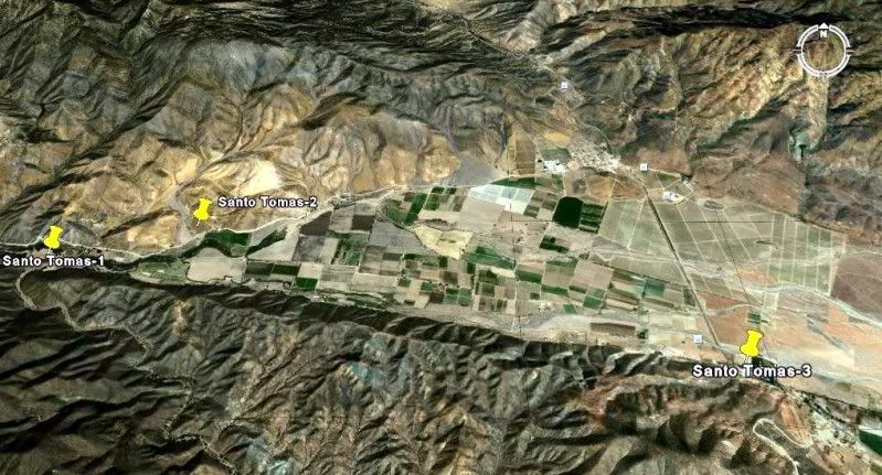
SANTO TOMAS-1 31º34'11.00" 116º28'50.00" Located by an oak grove picnic and camping area off the road to La Bocana, 3.9 miles from Hwy. 1.
SANTO TOMAS-2 31º34'24.30" 116º27'58.70" Located north of the La Bocana road in a pepper field, 2.8 miles from Hwy. 1.
SANTO TOMAS-3 31º33'30.00" 116º24'48.90" Located next to the El Palomar campground on Hwy. 1.
GPS ONLY:
EL DESCANSO 32º12'19.62" 116º54'19.24"
SAN MIGUEL 32º05'39.10" 116º51'15.03"
GUADALUPE 32º05'30.50" 116º34'30.50"
SANTA CATALINA 31º39'38.10" 115º49'16.00"
SANTO TOMAS-1 31º34'11.00" 116º28'50.00"
SANTO TOMAS-2 31º34'24.30" 116º27'58.70"
SANTO TOMAS-3 31º33'30.00" 116º24'48.90"
[Edited on 9-25-2009 by David K]
|
|
|
David K
Honored Nomad
Posts: 64490
Registered: 8-30-2002
Location: San Diego County
Member Is Offline
Mood: Have Baja Fever
|
|
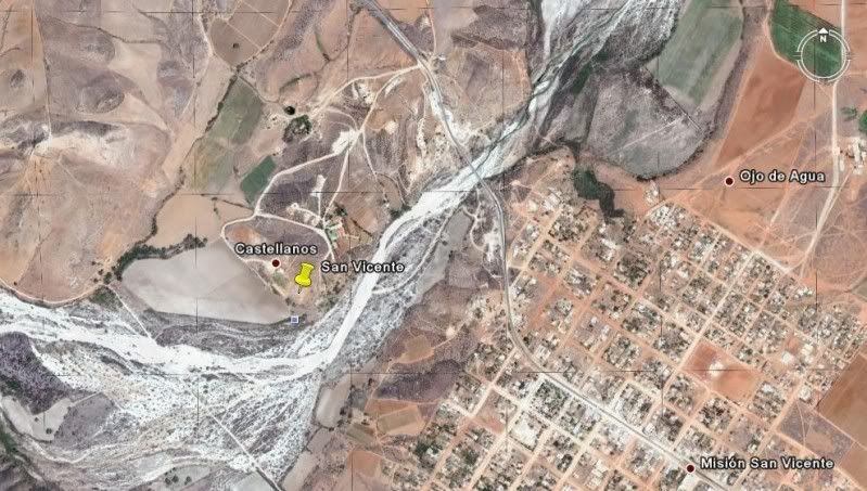
SAN VICENTE 31º19'47.90" 116º15'33.00" Located a short drive west of Hwy. 1, north of San Vicente. Well signed.
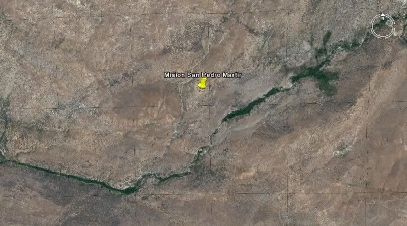
SAN PEDRO MARTIR 30º47'24.25" 115º28'20.85" Located over 5,000 feet above sea level and requires 2 days of backpacking to reach.
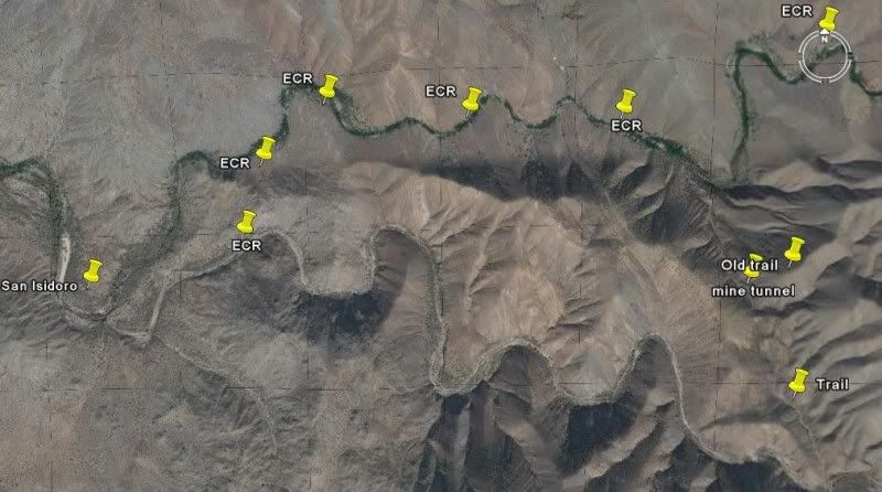
(Visita) SAN ISIDORO 30º45'55.17" 115º32'49.81" Located on the trail to Mision San Pedro Martir, several hours walk from the nearest road.
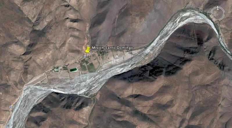
SANTO DOMINGO 30º46'15.20" 115º56'14.00" Located 5 miles east of Hwy. 1, just north of the Arroyo Santo Doming bridge, north of Colonia Vicente
Guerrero. Signed.
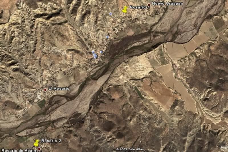
ROSARIO-1 30º04'01.00" 115º43'08.00" Located just off Hwy. 1 in El Rosario. Signed.
ROSARIO-2 30º02'29.00" 115º44'20.80" Located in the town of Rosario de Abajo, just over a mile from Hwy. 1.
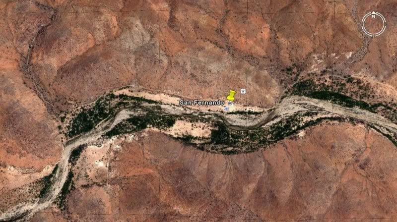
SAN FERNANDO VELICATA 29º58'16.52" 115º14'12.20" Located about 4 miles from Hwy. 1. Signed turnoff at Rancho Progreso.
(Visita) SAN JUAN DE DIOS 30º10'57.61" 115º10'04.50" Located above the east side of the arroyo, next to the road to Rancho El Metate, 22 miles from
Hwy. 1.
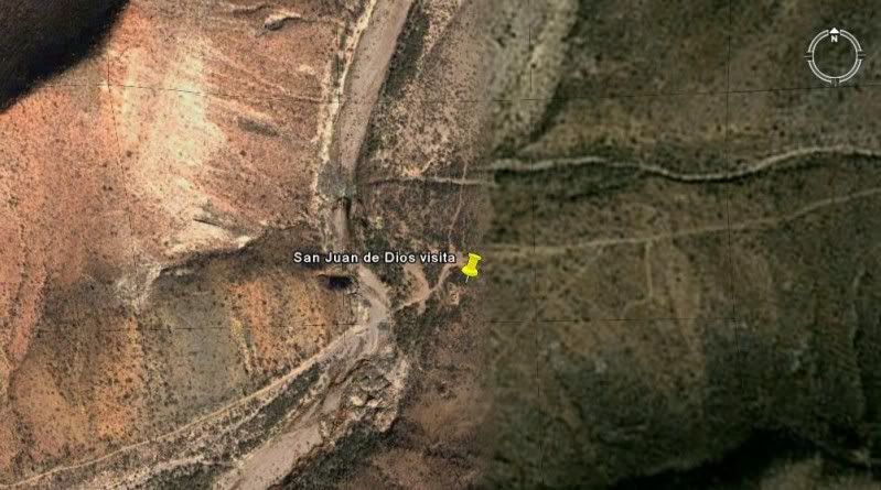
(note: site obliterated by farmer in 2008)
GPS ONLY:
SAN VICENTE 31º19'47.90" 116º15'33.00"
SAN PEDRO MARTIR 30º47'24.25" 115º28'20.85"
(Visita) SAN ISIDORO 30º45'55.17" 115º32'49.81"
SANTO DOMINGO 30º46'15.20" 115º56'14.00"
ROSARIO-1 30º04'01.00" 115º43'08.00"
ROSARIO-2 30º02'29.00" 115º44'20.80"
SAN FERNANDO VELICATA 29º58'16.52" 115º14'12.20"
(Visita) SAN JUAN DE DIOS 30º10'57.61" 115º10'04.50"
[Edited on 4-24-2009 by David K]
|
|
|
David K
Honored Nomad
Posts: 64490
Registered: 8-30-2002
Location: San Diego County
Member Is Offline
Mood: Have Baja Fever
|
|
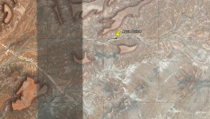
(Historic spring on El Camino Real) AGUA DULCE 29º52'58.70" 114º49'25.00" Located 2 miles east from Hwy. 1 at Km. 160-161.
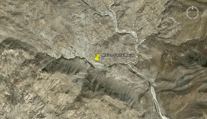
SANTA MARIA 29º43'54.50" 114º32'50.16" Located 14.5 miles from Rancho Santa Ynez over an extreme 4WD road.
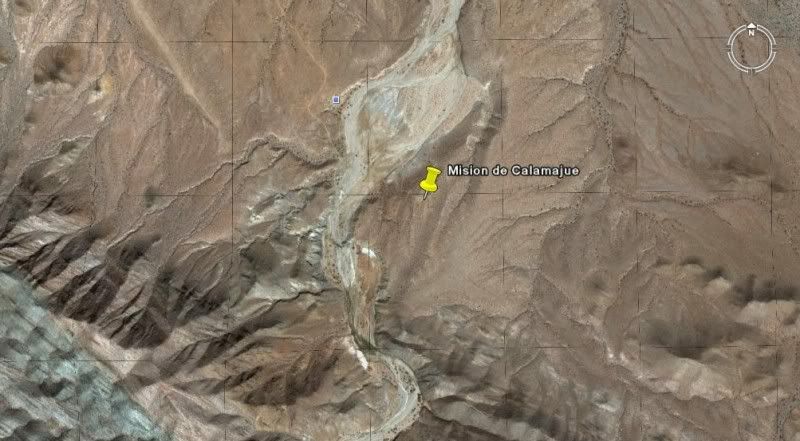
CALAMAJUE 29º25'16.30" 114º11'42.36" Located 15.5 miles north of Hwy. 1 (Km. 261) or 14 miles east and south of Coco's Corner, on the east bank of
Arroyo Calamajue.
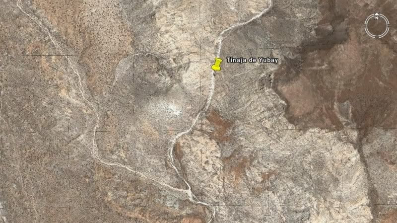
(Historic water hole near El Camino Real) TINAJA DE YUBAY 29º10'41.37" 113º59'15.20" Located north of the L.A. Bay highway off the road signed 'Rancho
San Luis'.
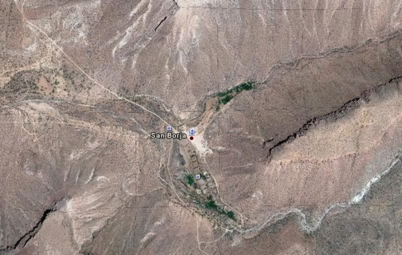
SAN BORJA 28º44'40.37" 113º45'14.39" Well signed 21 miles south of L.A. Bay highway or east of Hwy. 1 at Nuevo Rosarito.
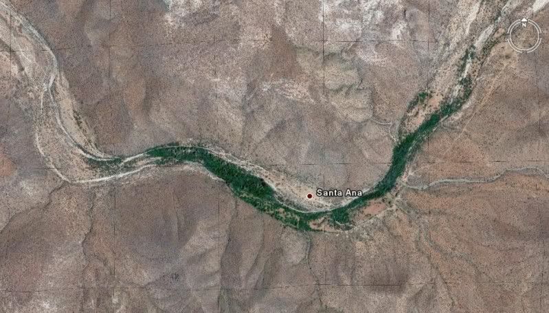
(Visita) SANTA ANA 28º41'25.23" 113º49'14.31" Located south of the San Borja/ Nuevo Rosarito road.
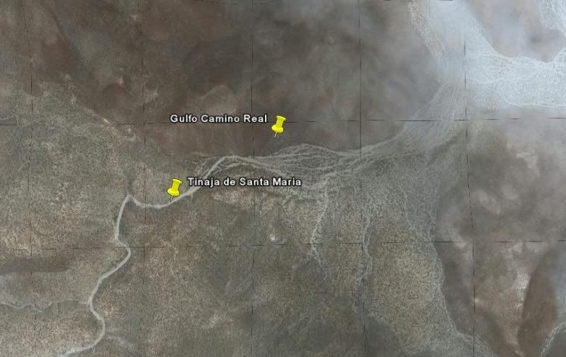
(Water hole near Golfo Camino Real) TINAJA DE SANTA MARIA 28º26'05.20" 113º20'01.40" Located south from the old road to San Francisquito, south of
Bahia de los Angeles and just east of Rancho La Bocana (San Pedro).
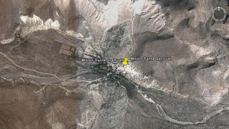
SANTA GERTRUDIS 28º03'04.02" 113º05'07.17" Access roads from El Arco, Guillermo Prieto and San Francisquito/ El Barril.
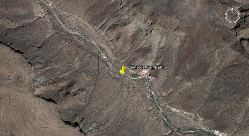
(Visita) SAN PABLO 27º42'07.81" 113º08'42.08" Located in San Pablo Canyon, east of Vizcaino. Access may be restricted without a guide.
GPS ONLY:
(Historic spring on El Camino Real) AGUA DULCE 29º52'58.70" 114º49'25.00"
SANTA MARIA 29º43'54.50" 114º32'50.16"
CALAMAJUE 29º25'16.30" 114º11'42.36"
(Historic water hole near El Camino Real) TINAJA DE YUBAY 29º10'41.37" 113º59'15.20"
SAN BORJA 28º44'40.37" 113º45'14.39"
(Visita) SANTA ANA 28º41'25.23" 113º49'14.31"
(Water hole near Golfo Camino Real) TINAJA DE SANTA MARIA 28º26'05.20" 113º20'01.40"
SANTA GERTRUDIS 28º03'04.02" 113º05'07.17"
(Visita) SAN PABLO 27º42'07.81" 113º08'42.08"
[Edited on 4-27-2009 by David K]
|
|
|
David K
Honored Nomad
Posts: 64490
Registered: 8-30-2002
Location: San Diego County
Member Is Offline
Mood: Have Baja Fever
|
|
| Quote: | Originally posted by bajaamy
Well done, David. You've contributed mightily to the body of information about missions and visitas!
Is there anything to see at San Isidoro? What do we know about it? |
Did you look at the photos, in Part 3?: http://vivabaja.com/missions3 (also linked from Part 1 & Part 2 of the revised mission pages). They were taken by Nomad member 'Kevin in
Oklahoma' in 2005 when he rode a quad there from San Quintin.
I have not been there...
Graham Mackintosh in his second book 'Journey with a Baja Burro' was marooned there during heavy El Niño rain... while trying to get up to Mision San
Pedro Martir.
Jack Swords, Mexitron, Taco de Baja, & Pappy are the Nomads who passed through on their way to the mission in 2004.
[Edited on 9-21-2009 by David K]
|
|
|
David K
Honored Nomad
Posts: 64490
Registered: 8-30-2002
Location: San Diego County
Member Is Offline
Mood: Have Baja Fever
|
|
My pleasure!
More coming soon (Baja Sur missions & visitas)!
|
|
|
David K
Honored Nomad
Posts: 64490
Registered: 8-30-2002
Location: San Diego County
Member Is Offline
Mood: Have Baja Fever
|
|
MORE IMAGES ADDED!
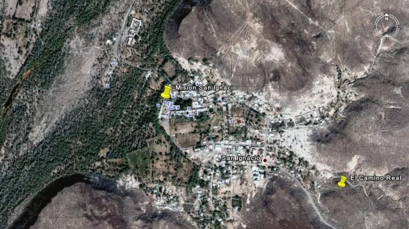
SAN IGNACIO 27º17'02.18" 112º53'56.12" Facing the town plaza of San Ignacio.
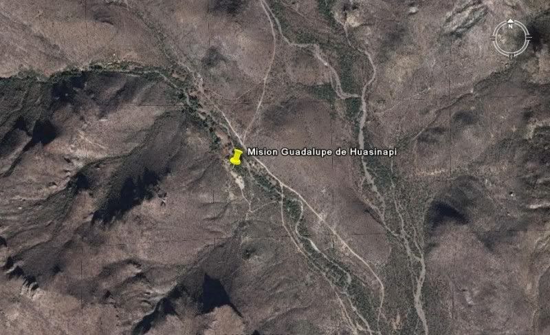
GUADALUPE 26º55'09.50" 112º24'20.60" Signed as the 'ex-mision' of Guadalupe, east of San Jose de Magdalena in the mountains northwest of Mulege.
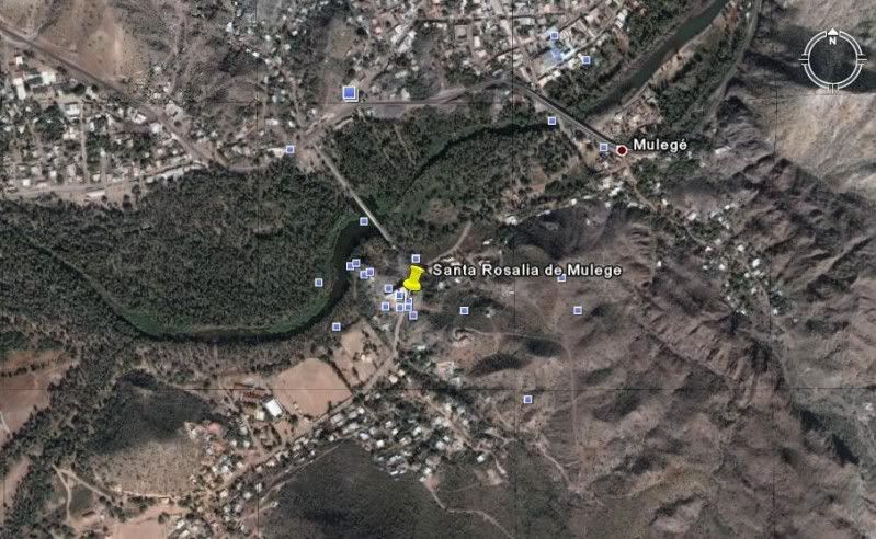
SANTA ROSALIA DE MULEGE 26º05'37.00" 111º59'09.30" On the south side of the river, just west of the highway bridge in Mulege.
(Visita) SAN JOSE DE MAGDALENA 27º03'40.33" 112º13'24.87" Just east of the town on the south side of the arroyo, north of Mulege.
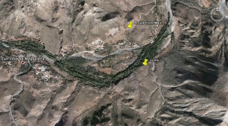
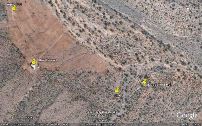
(Pila/ ag site for San Jose de Magdalena, mis-identified as Mision Santa Maria Magdalena) 27º03'29.10" 112º10'12.34" Located just outside the canyon
'Boca de Magdalena' east of Palo Verde, north of Mulege. The stone building ruins are on both sides of the road at 27º03'29.90" 112º10'07.40", 4.6
miles from Hwy. 1 at Km.162.5 (take left road at mile 3.7).
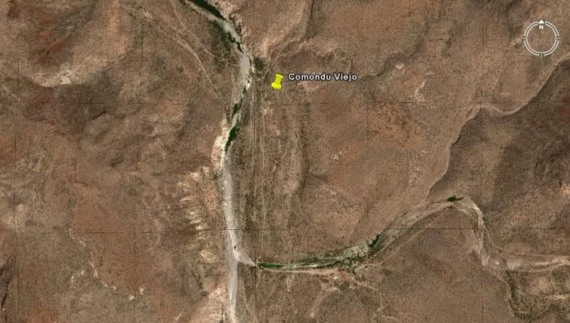
SAN JOSE DE COMONDU (1st site, 'Comondu Viejo') 26º16'27.40" 111º43'08.50" On the old transpeninsular road between ranchos of San Juan and La Presa.
11 miles west of wy. 1 on the La Purisima road (south of Bahia Concepcion), turn south for 9 miles. 22 miles north of town of Comondu.
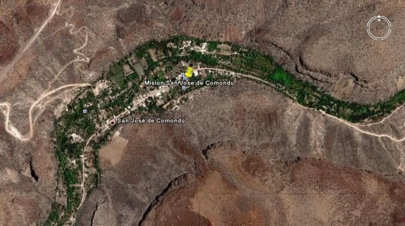
SAN JOSE DE COMONDU (final site) 26º03'34.59" 111º49'20.41" In the town of San Jose Comondu.
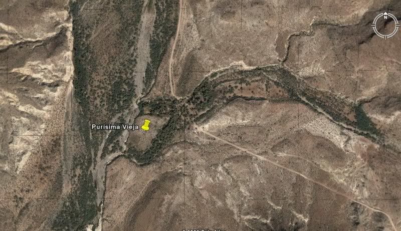
LA PURISIMA (1st site, 'Purisima Vieja') 26º18'34.48" 112º09'50.98" Located 16 miles north of San Isidro, 3.4 miles south of Paso Hondo.
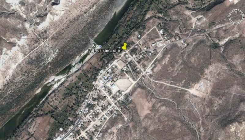
LA PURISIMA (final site) 26º11'25.60" 112º04'22.60" In the town of La Purisima.
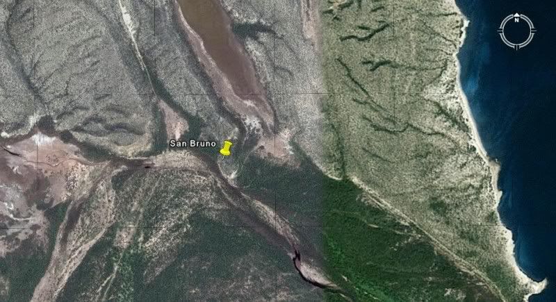
SAN BRUNO (1683-1685 colony site) 26º13'57.50" 111º23'53.90" 14 miles north of Loreto near, the coast on a hill.
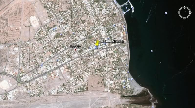
LORETO 26º00'37.00" 111º20'35.80" In the center of town.
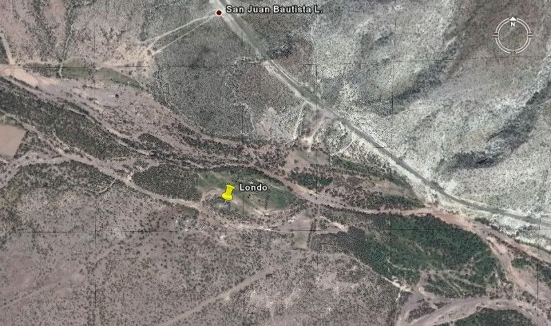
(Visita) SAN JUAN BAUTISTA LONDO 26º13'30.83" 111º28'24.51" About 17 miles north of Loreto and just west of Hwy. 1, next to a ranch. Ruins visible
from the highway.
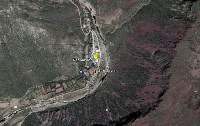
SAN JAVIER 25º51'36.86" 111º32'36.99" 22 miles west and south from Loreto, well signed.
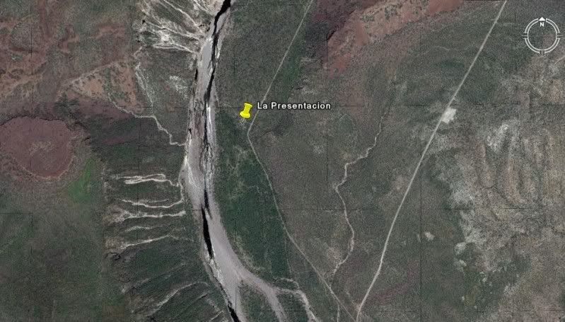
(Visita) LA PRESENTACION 25º43'45.00" 111º32'37.40" About 11 miles south of San Javier.
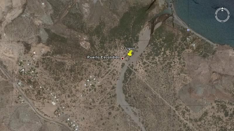
SAN JUAN BAUTISTA DE LIGUI/ DE MALIBAT 25º44'22.20" 111º15'51.00" (no remains, arroyo swallowed ruins in 2001) At the southeast junction of the road
to Playa Ligui and Ensenada Blanca, just east of Hwy. 1, nine miles south of Puerto Escondido.
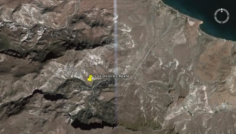
LOS DOLORES APATE 25º03'19.04" 110º53'03.33" Access by foot/ mule trail off road to Los Burros about 15 miles norteast of La Presa and Los Dolores
Chilla (La Pasion).
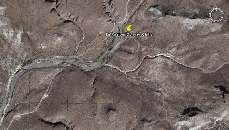
LOS DOLORES CHILLA (La Pasion) 24º53'14.4" 111º01'49.81" Just east of Rancho La Presa at Rancho La Capilla off the road to San Pedro de la Presa.
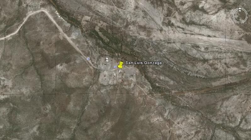
SAN LUIS GONZAGA 24º54'29.00" 111º17'27.25" Off the road to Presa el Ihuajal, 10 miles south of Ciudad Constitucion.
GPS ONLY:
SAN IGNACIO 27º17'02.18" 112º53'56.12"
GUADALUPE DE HUASINAPI 26º55'09.50" 112º24'20.60"
SANTA ROSALIA DE MULEGE 26º05'37.00" 111º59'09.30"
(Visita) SAN JOSE DE MAGDALENA 27º03'40.33" 112º13'24.87"
(Pila/ ag site for San Jose de Magdalena, mis-identified as Mision Santa Maria Magdalena) 27º03'29.10" 112º10'12.34"
SAN JOSE DE COMONDU (1st site, 'Comondu Viejo') 26º16'27.40" 111º43'08.50"
SAN JOSE DE COMONDU (final site) 26º03'34.59" 111º49'20.41"
LA PURISIMA (1st site, 'Purisima Vieja') 26º18'34.48" 112º09'50.98"
LA PURISIMA (final site) 26º11'25.60" 112º04'22.60"
SAN BRUNO (1683-1685 colony site) 26º13'57.50" 111º23'53.90"
LORETO 26º00'37.00" 111º20'35.80"
(Visita) SAN JUAN BAUTISTA LONDO 26º13'30.83" 111º28'24.51"
SAN JAVIER 25º51'36.86" 111º32'36.99"
(Visita) LA PRESENTACION 25º43'45.00" 111º32'37.40"
SAN JUAN BAUTISTA DE LIGUI/ DE MALIBAT 25º44'22.20" 111º15'51.00"
LOS DOLORES APATE 25º03'19.04" 110º53'03.33"
LOS DOLORES CHILLA (La Pasion) 24º53'14.4" 111º01'49.81"
SAN LUIS GONZAGA 24º54'29.00" 111º17'27.25"
PILAR DE LA PAZ AIRAPI 24º09'36.00" 110º18'59.40"
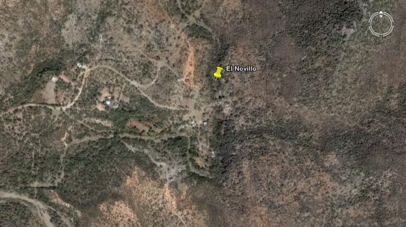
(Visita) EL NOVILLO 23º55'48.60" 110º13'28.20"
(Visita) ANGEL DE LA GUARDA (EL ZALATO) 23º53'27.60" 110º10'14.80"
(a church from the 1760's) SAN BLAS 23º53'10.40" 110º09'16.21"
SANTA ROSA DE LAS PALMAS (Todos Santos-1) 23º27'37.30" 110º13'08.31"
PILAR DE LA PAZ (Todos Santos-2) 23º26'59.16" 110º13'31.62"
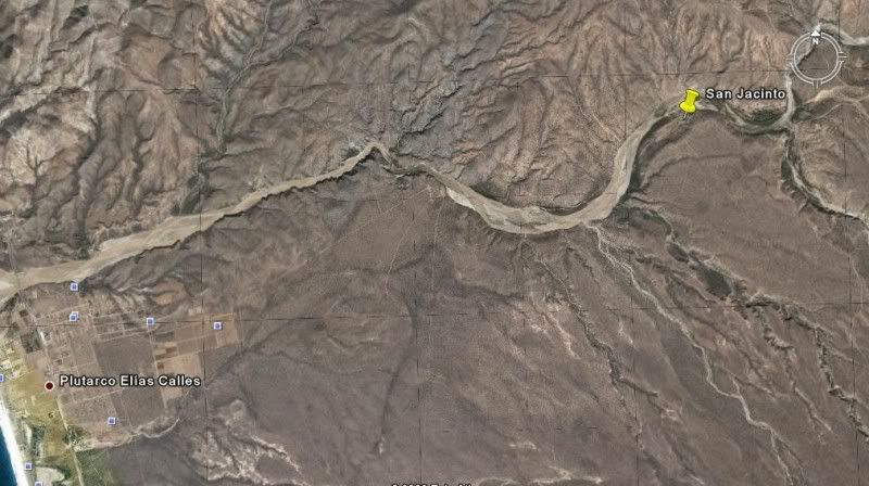
(Visita) SAN JACINTO 23º14'34.21" 110º04'37.20"
[Edited on 8-5-2009 by David K]
|
|
|
David K
Honored Nomad
Posts: 64490
Registered: 8-30-2002
Location: San Diego County
Member Is Offline
Mood: Have Baja Fever
|
|
Okay.... all missions images north of La Paz are now posted, above!
Coming next the La Paz mission visitas and Todos Santos images and visita image...
No ruins at any of the San Jose del Cabo 4 mission sites, so no photos or GPS.. The church on the town plaza is built upon the final site, however.
No ruins for Santiago other than the foundation stones photographed at the first site... no GPS or satellite image by request of the ranch owner. The
town church is built on the final site. However, some authors mention a final site being in Caduaño... ?
|
|
|
24baja
Senior Nomad
Posts: 951
Registered: 2-3-2009
Location: Grants Pass Oregon/Bahia de Los Angeles
Member Is Offline
Mood: Wishing we were in BOLA
|
|
David I am in awe of how knowledgeable you are, I take it you have been a Baja R for a very long time, I wish we had grown up in Baja during vacations
and such. I guess it is never too late to fall in love with Baja and start that forever romance. Well, thanks again for all the info you post for us
new nomads. Connie
|
|
|
David K
Honored Nomad
Posts: 64490
Registered: 8-30-2002
Location: San Diego County
Member Is Offline
Mood: Have Baja Fever
|
|
| Quote: | Originally posted by 24baja
David I am in awe of how knowledgeable you are, I take it you have been a Baja R for a very long time, I wish we had grown up in Baja during vacations
and such. I guess it is never too late to fall in love with Baja and start that forever romance. Well, thanks again for all the info you post for us
new nomads. Connie |
Thanks Connie... if you read my bio on my web site, you will get an idea of why Baja is such a big part of me. I really do feel connected with the
peninsula... specially the central part with its wild, unearth-like geography, where there are so many mission sites, the Camino Real. palm canyons,
beautiful beaches... I was very fortunate that my parents fell in love with the place back in the 60's and that I learned about the history of the
land and people so young... It has had a profound affect on my life.
|
|
|
David K
Honored Nomad
Posts: 64490
Registered: 8-30-2002
Location: San Diego County
Member Is Offline
Mood: Have Baja Fever
|
|
LA PAZ MISSION VISITAS +
(Visita) EL NOVILLO 23º55'48.60" 110º13'28.20" (perhaps a visita of the La Paz mission... Pin location and GPS from Jack Swords)
(Visita) ANGEL DE LA GUARDA (EL ZALATO) 23º53'27.60" 110º10'14.80" (a visita of the La Paz mission)
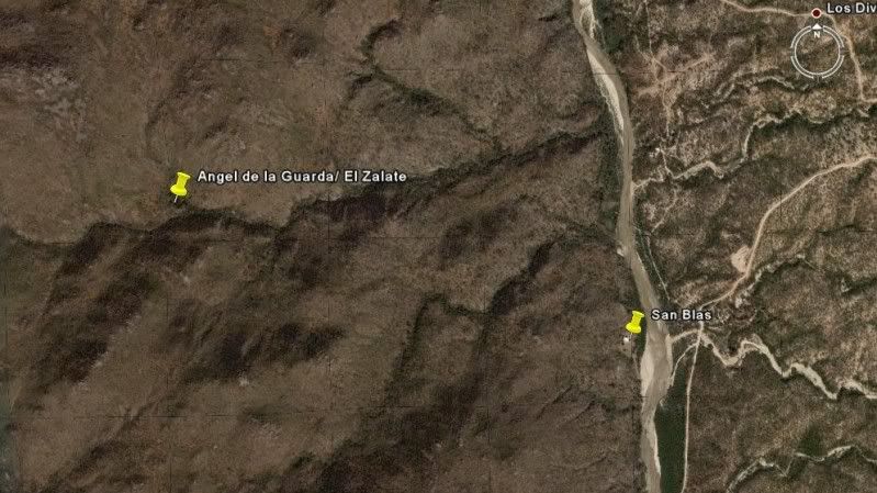
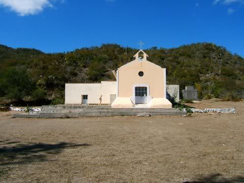
SAN BLAS (a church from the 1760's village) down the hill from El Zalato 23º53'10.40" 110º09'16.21"
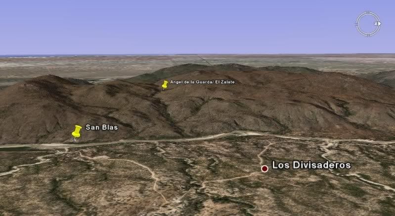
(view sideways and looking west)
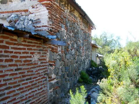
Note new construction added to 1760's walls.
TO BE CONTINUED!
|
|
|
David K
Honored Nomad
Posts: 64490
Registered: 8-30-2002
Location: San Diego County
Member Is Offline
Mood: Have Baja Fever
|
|
TODOS SANTOS
There are two mission sites for Todos Santos.
The first site began as a visita for the La Paz mission (named 'Todos Santos'), then became a seperate mission named 'Santa Rosa de las Palmas'...
some stone walls are all that remain and a modern church is built on the site: 23º27'37.30" 110º13'08.31"]
The La Paz mission (Nuestra Señora del Pilar de la Paz) moved from the Bay of La Paz to Todos Santos and that ended the Santa Rosa mission...
The second site is the location of the modern town church of Todos Santos, where the mission moved. 23º26'59.16" 110º13'31.62"
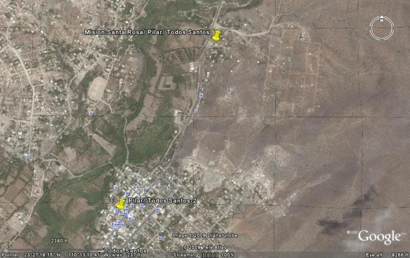
(Visita) SAN JACINTO 23º14'34.21" 110º04'37.20"
For Mission & Visita details: http://vivabaja.com/bajamissions
[Edited on 9-23-2009 by David K]
|
|
|
David K
Honored Nomad
Posts: 64490
Registered: 8-30-2002
Location: San Diego County
Member Is Offline
Mood: Have Baja Fever
|
|
Below the images for San Borja and Santa Ana, I have added Tinaja de Santa Maria off the Golfo Camino Real.
|
|
|
David K
Honored Nomad
Posts: 64490
Registered: 8-30-2002
Location: San Diego County
Member Is Offline
Mood: Have Baja Fever
|
|
I added the photos of the San Blas church to the Visitas (Part 3) web page. It dates from 1760, but I am unclear if it was a mission visita or a
parish church for San Blas. In theory, the Jesuits were in total control of California until 1768... However, the silver mines south of La Paz seemed
to be seperated from the mission system.
Part 3: http://vivabaja.com/missions3
[Edited on 9-21-2009 by David K]
|
|
|
David K
Honored Nomad
Posts: 64490
Registered: 8-30-2002
Location: San Diego County
Member Is Offline
Mood: Have Baja Fever
|
|
The mission sites in the back country are best found using a GPS receiver. Some road directions are being added to give you some idea how to reach the
mission sites. Only a few sites cannot be reached by road (San Pedro Martir, San Isidoro, San Pablo, Los Dolores Apate, Angel de la Guarda). One
requires a sturdy off road vehicle (Santa Maria) and the rest are on usually good roads or highways with a short walk or none at all...
[Edited on 4-20-2009 by David K]
|
|
|
David K
Honored Nomad
Posts: 64490
Registered: 8-30-2002
Location: San Diego County
Member Is Offline
Mood: Have Baja Fever
|
|
GPS WAYPOINTS for mission sites (map datum WGS84)
EL DESCANSO-1 32º11'59.40" 116º54'30.00"
EL DESCANSO-2 32º12'19.62" 116º54'19.24"
SAN MIGUEL 32º05'39.10" 116º51'15.03"
GUADALUPE 32º05'30.50" 116º34'30.50"
SANTA CATALINA 31º39'38.10" 115º49'16.00"
SANTO TOMAS-1 31º34'11.00" 116º28'50.00"
SANTO TOMAS-3 31º33'30.00" 116º24'48.90"
SAN VICENTE 31º19'47.90" 116º15'33.00"
SAN PEDRO MARTIR 30º47'24.25" 115º28'20.85"
(Visita) SAN ISIDORO 30º45'55.17" 115º32'49.81"
SANTO DOMINGO 30º46'15.20" 115º56'14.00"
ROSARIO-1 30º04'01.00" 115º43'08.00"
ROSARIO-2 30º02'29.00" 115º44'20.80"
SAN FERNANDO VELICATA 29º58'16.52" 115º14'12.20"
(Visita) SAN JUAN DE DIOS 30º10'57.61" 115º10'04.50"
(Historic spring on El Camino Real) AGUA DULCE 29º52'58.70" 114º49'25.00"
SANTA MARIA 29º43'54.50" 114º32'50.16"
CALAMAJUE 29º25'16.30" 114º11'42.36"
(Historic water hole near El Camino Real) TINAJA DE YUBAY 29º10'41.37" 113º59'15.20"
SAN BORJA 28º44'40.37" 113º45'14.39"
(Visita) SANTA ANA 28º41'25.23" 113º49'14.31"
(Water hole near Golfo Camino Real) TINAJA DE SANTA MARIA 28º26'05.20" 113º20'01.40"
SANTA GERTRUDIS 28º03'04.02" 113º05'07.17"
(Visita) SAN PABLO 27º42'07.81" 113º08'42.08"
SAN IGNACIO 27º17'02.18" 112º53'56.12"
GUADALUPE DE HUASINAPI 26º55'09.50" 112º24'20.60"
SANTA ROSALIA DE MULEGE 26º05'37.00" 111º59'09.30"
(Visita) SAN JOSE DE MAGDALENA 27º03'40.33" 112º13'24.87"
(Pila/ ag site for San Jose de Magdalena, mis-identified as Mision Santa Maria Magdalena) 27º03'29.10" 112º10'12.34"
SAN JOSE DE COMONDU (1st site, 'Comondu Viejo') 26º16'27.40" 111º43'08.50"
SAN JOSE DE COMONDU (final site) 26º03'34.59" 111º49'20.41"
LA PURISIMA (1st site, 'Purisima Vieja') 26º18'34.48" 112º09'50.98"
LA PURISIMA (final site) 26º11'25.60" 112º04'22.60"
SAN BRUNO (1683-1685 colony site) 26º13'57.50" 111º23'53.90"
LORETO 26º00'37.00" 111º20'35.80"
(Visita) SAN JUAN BAUTISTA LONDO 26º13'30.83" 111º28'24.51"
SAN JAVIER 25º51'36.86" 111º32'36.99"
(Visita) LA PRESENTACION 25º43'45.00" 111º32'37.40"
SAN JUAN BAUTISTA DE LIGUI/ DE MALIBAT 25º44'22.20" 111º15'51.00"
LOS DOLORES APATE 25º03'19.04" 110º53'03.33"
LOS DOLORES CHILLA (La Pasion) 24º53'14.4" 111º01'49.81"
SAN LUIS GONZAGA 24º54'29.00" 111º17'27.25"
PILAR DE LA PAZ AIRAPI 24º09'36.00" 110º18'59.40"
(Visita) EL NOVILLO 23º55'48.60" 110º13'28.20"
(Visita) ANGEL DE LA GUARDA (EL ZALATO) 23º53'27.60" 110º10'14.80"
(a church from the 1760's) SAN BLAS 23º53'10.40" 110º09'16.21"
SANTA ROSA DE LAS PALMAS (Todos Santos-1) 23º27'37.30" 110º13'08.31"
PILAR DE LA PAZ (Todos Santos-2) 23º26'59.16" 110º13'31.62"
(Visita) SAN JACINTO 23º14'34.21" 110º04'37.20"
[Edited on 5-6-2009 by David K]
|
|
|
Mexitron
Ultra Nomad
Posts: 3397
Registered: 9-21-2003
Location: Fort Worth, Texas
Member Is Offline
Mood: Happy!
|
|
Hey David--another great report! I'm one step closer to checking out some of these in person--just got a new Tacoma...!
|
|
|
David K
Honored Nomad
Posts: 64490
Registered: 8-30-2002
Location: San Diego County
Member Is Offline
Mood: Have Baja Fever
|
|
| Quote: | Originally posted by Mexitron
Hey David--another great report! I'm one step closer to checking out some of these in person--just got a new Tacoma...! |
That's great to hear Steve! I hope your new Tacoma works out as well as my two have!
Too bad that you are now 2 days drive from the Baja border... You are one of the few Nomads who have been to the most remote Baja mission (San Pedro
Martir), and that alone is a worthy accomplishment!
|
|
|
Mexitron
Ultra Nomad
Posts: 3397
Registered: 9-21-2003
Location: Fort Worth, Texas
Member Is Offline
Mood: Happy!
|
|
Well..... almost a two day drive--I did it in 22 hours straight with a loaded to the hilt truck...others say they can make in 19 hours ( this is how I
psyche myself into thinking Baja isn't so far away  ) )
|
|
|
David K
Honored Nomad
Posts: 64490
Registered: 8-30-2002
Location: San Diego County
Member Is Offline
Mood: Have Baja Fever
|
|
Gee... last year we took 2 days to get to Carlsbad NM, via El paso... But we are old... 
Looking forward to a return to the Caverns... they are awesome!
|
|
|
Mexitron
Ultra Nomad
Posts: 3397
Registered: 9-21-2003
Location: Fort Worth, Texas
Member Is Offline
Mood: Happy!
|
|
A coworker's friend drove from Fort Worth to San Diego a while back--when he was half way there the friend called to check in--when asked where he was
he said he was still in Texas!
If need be we can always make a run to Big Bend National Park--which David, you should do sometime if you're out this far--Chihuahuan Desert with some
familiar Sonoran elements mixed in (Ocotillo, Creososte...). The mountains are granitic mixed with old limestone and volcanic so quite an interesting
place too...
|
|
|
| Pages:
1
2 |
|


