David K
Honored Nomad

Posts: 64476
Registered: 8-30-2002
Location: San Diego County
Member Is Offline
Mood: Have Baja Fever
|
|
New! MAY 2009 SHELL ISLAND WEB PAGE
Well... it seemed like there weren't going to be as many Baja trips for us in 2009, earlier in the year... But, you just can't beat a trip to Baja as
much as the Baja tries to beat you out of going!
The year did start out great with BajaLou's final turkey feast and a night at BajaRob's beachhouse... on our way to a great discovery... finding
Choral Pepper's long, lost mission of Santa Maria Magdalena thanks to a clue from Sharksbaja who saw the walls from space images. http://vivabaja.com/109
Then it was nearly five months before we returned to Baja with the Memorial Day Weekend trip to Shell Island... and a return on July 4th weekend...
Now we are ready for our One Year Anniversary trip to San Ignacio, Mulege/Playa Frambes and Loreto!
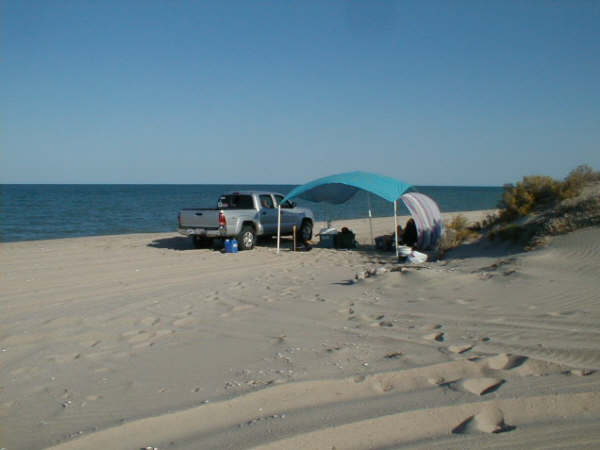
So, before I get too far backlogged... I made a web page of our Memorial Day Shell Island trip... Here it is: 509 Shell Island
|
|
|
Bob H
Elite Nomad
Posts: 5867
Registered: 8-19-2003
Location: San Diego
Member Is Offline
|
|
Looks like you had a very nice time there. How can you NOT have a nice time in a place like that? Thanks for sharing your trip on Nomad land.
Bob H
|
|
|
David K
Honored Nomad
Posts: 64476
Registered: 8-30-2002
Location: San Diego County
Member Is Offline
Mood: Have Baja Fever
|
|
Thanks Bob... Yah, you just can't beat a beautiful beach when it is all to yourself!
BajaRob and Connie rode up on their quads to visit, as well... It is a great place!
|
|
|
Bob H
Elite Nomad
Posts: 5867
Registered: 8-19-2003
Location: San Diego
Member Is Offline
|
|
I think Shell Island is your all time favorite place to visit in Baja. Bob H
|
|
|
David K
Honored Nomad
Posts: 64476
Registered: 8-30-2002
Location: San Diego County
Member Is Offline
Mood: Have Baja Fever
|
|
| Quote: | Originally posted by Bob H
I think Shell Island is your all time favorite place to visit in Baja. Bob H |
For sure it is my favorite place to camp, relax, and 'beach' at!


|
|
|
David K
Honored Nomad
Posts: 64476
Registered: 8-30-2002
Location: San Diego County
Member Is Offline
Mood: Have Baja Fever
|
|
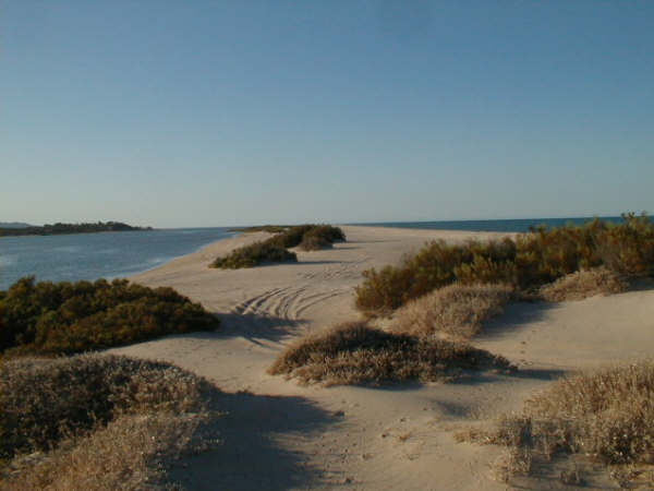
The reason I take photos of the same view each trip is to compare and show that the coastline is unchanged (ie. no sea level rising) for the past 35
years...
The dunes are just above the high tide line and during extreme tides and storms, the ocean has washed over the island between the dunes. But the
typical high tide remains as it was when I first started going out there. If the sea level was rising, then the island would be cut off from Baja, all
the time (every high tide) and eventually wash away. Not in my lifetime, so far!
The same is true for other Sea of Cortez coast locations. Erosion can move sand and collapse cliffs, but the sea level is the same.
|
|
|
mtgoat666
Select Nomad
Posts: 17280
Registered: 9-16-2006
Location: San Diego
Member Is Offline
Mood: Hot n spicy
|
|
| Quote: | Originally posted by David K
The reason I take photos of the same view each trip is to compare and show that the coastline is unchanged (ie. no sea level rising) for the past 35
years...
The dunes are just above the high tide line and during extreme tides and storms, the ocean has washed over the island between the dunes. But the
typical high tide remains as it was when I first started going out there. If the sea level was rising, then the island would be cut off from Baja, all
the time (every high tide) and eventually wash away. Not in my lifetime, so far!
The same is true for other Sea of Cortez coast locations. Erosion can move sand and collapse cliffs, but the sea level is the same.
|

dk, cancel your subscripions to "Flat Earth Society," "Anti-Science," and "Creationism." The island will likely rise in elevation as the sea level
rises, because winds and currents will continue to deposit sediment on this "barrier island."
Next time you are there, set a steel stake (piece of rebar, and sledge hammer to drive it 5 feet deep to ensure it is fixed) and check it as you
return each year. Then you will begin to have a basis to make statements that shoreline has/has not changed.
|
|
|
David K
Honored Nomad
Posts: 64476
Registered: 8-30-2002
Location: San Diego County
Member Is Offline
Mood: Have Baja Fever
|
|
Open your eyes or actually go to the coast of Baja, getting onto the island requires driving across a salt flat that is a fewinches above the typical
high tide line and what makes it an island at the highest lunar tides. If the sea level had risen just 6 inches in the past 35 years, that salt flat
would be under water at every high tide, every day.
It may serve your big government, less freedom ideals to swallow the load from algore, but I am out there, on the beach... not in some mansion paid
for with carbon offset credit sales!
This is not a discussion forum, it is a classified ads forum for 'My Baja Website'... Do you make any web sites to show Baja, for free?
|
|
|
SKIDS
Junior Nomad
Posts: 48
Registered: 3-10-2009
Location: Jamul Ca.
Member Is Offline
|
|
666 is trying to get your goat DK !
|
|
|
makana.gabriel
Nomad
Posts: 115
Registered: 1-10-2008
Location: Honolulu
Member Is Offline
|
|
Nice site David. You do good work!!
FAITH sees the invisible, believes the incredible, and receives the impossible!
|
|
|
The Sculpin
Nomad
Posts: 401
Registered: 9-3-2002
Location: Back in the Saddle
Member Is Offline
Mood: Riding into the Sunset, looking for a sunrise.
|
|
Did you even bother to show up for your high school science class?!?!? DK, it's a good thing you're a master irrigation dude. Is there any way you can
take a 3 dimensional GPS reading of shell island? Do that for 35 years and you'll have some relevant and irrefutable data points to draw a conclusion.
Whoa there, Cowboy - pull back on those reins!
|
|
|
David K
Honored Nomad
Posts: 64476
Registered: 8-30-2002
Location: San Diego County
Member Is Offline
Mood: Have Baja Fever
|
|
I got high grades in science, thank you... I also can do my own thinking.
The salt flat does not change elevation, even if a sand beach does.
I am still waiting for an explanation as why the rocky sea shores (like Concepcion Bay are still the same? The old Baja road carved into the cliffs
south of Mulege is right at the high tide line in places... and still is!
Unless the Baja peninsula is rising at the same rate as the sea level... One can only conclude from observation, that the sea level is at or very near
the same place it has been for 50 years.
|
|
|
wessongroup
Platinum Nomad
Posts: 21152
Registered: 8-9-2009
Location: Mission Viejo
Member Is Offline
Mood: Suicide Hot line ... please hold
|
|
Nice shots, and you guys are great to share your trips... I'm mean really!!
I was only down that side one time back in 1972 to San Felipe, enjoyed myself shooting bottle rocks at the kites we had flying and drinking beer..
much different than the Pacific, but we are going to try and get down a bit lower in the Baja next month. Hope I can do as well on the pictures and
reports all you folks do, super..
Will close with this quote "Dr John Church of the Centre for Australian Weather and Climate Research, Hobart, Tasmania, Australia and the lead speaker
in the sea level session, told the conference, "The most recent satellite and ground based observations show that sea-level rise is continuing to rise
at 3 mm/yr or more since 1993, a rate well above the 20th century average. The oceans are continuing to warm and expand, the melting of mountain
glacier has increased and the ice sheets of Greenland and Antarctica are also contributing to sea level rise."
Pretty hard to measure 3 mm a year let alone "see", and at my age with my vision no way...
So keep it up, that is the way to do it... good man on the job.. and the pictures will tell the story, let them speak
|
|
|


