| Pages:
1
2 |
David K
Honored Nomad

Posts: 64476
Registered: 8-30-2002
Location: San Diego County
Member Is Offline
Mood: Have Baja Fever
|
|
BAJA'S MISSION SITES (FROM SPACE)
This data and space images has been posted previously, but put together here for ease of use by the Baja historic adventure seekers.
(NOTE: NEW WEB PAGE FOR THIS IS U.C., but please feel free to have a look: http://vivabaja.com/missions4 )
Satellite images from Google Earth and GPS datum is set to WGS84 (factory standard setting) if you need help in visiting these sites in person.
Details and photos of the missions and visitas can be found at http://vivabaja.com/bajamissions
Satellite images are all oriented with north at the top, unless otherwise noted.
From North to South...
EL DESCANSO 32°12'19.62" 116°54'19.24" Located behind a church that can be seen from the Ensenada toll road. An exit just north once was signed for
the mission, but has been renamed 'Rancho Descanso'. Access from the free road along the lagoon/ arroyo, under the toll road bridge (south of the
Cantamar sand dunes). The original site (1817-1830) and fort location (Descanso-1/Fort) is to the south of the arroyo, on the hill: 32°11'59.40"
116°54'30.00"
SAN MIGUEL 32°05'39.10" 116°51'15.03" Located right on the free road in La Mision, next to a school on the north side of the road.
GUADALUPE 32°05'30.50" 116°34'30.50" Located on a dirt street off the entrance paved road going through Guadalupe (Francisco Zarco) from Highway 3.
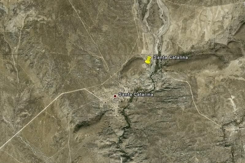
SANTA CATALINA 31°39'38.10" 115°49'16.00" Located on a hilltop overlooking a cemetery on the far side of the community of Santa Catarina, east of
Ejido Independencia off Hwy. 3.
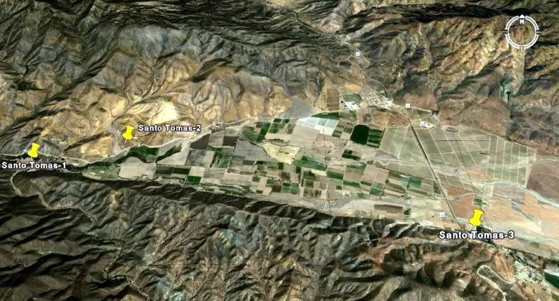
SANTO TOMAS-1 31°34'11.00" 116°28'50.00" Located by an oak grove picnic and camping area off the road to La Bocana, 3.9 miles from Hwy. 1.
SANTO TOMAS-2 31°34'24.30" 116°27'58.70" Located north of the La Bocana road in a pepper field, 2.8 miles from Hwy. 1.
SANTO TOMAS-3 31°33'30.00" 116°24'48.90" Located next to the El Palomar campground on Hwy. 1.
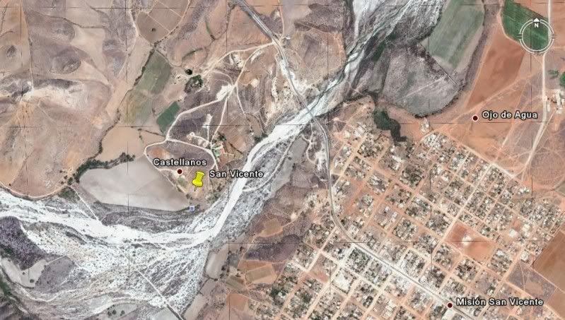
SAN VICENTE 31°19'47.90" 116°15'33.00" Located a short drive west of Hwy. 1, north of San Vicente. Well signed.
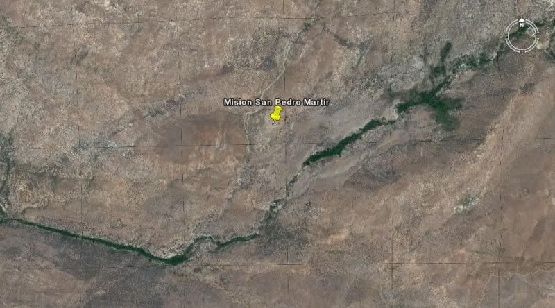
SAN PEDRO MARTIR 30°47'24.25" 115°28'20.85" Located over 5,000 feet above sea level and requires 2 days of backpacking to reach.
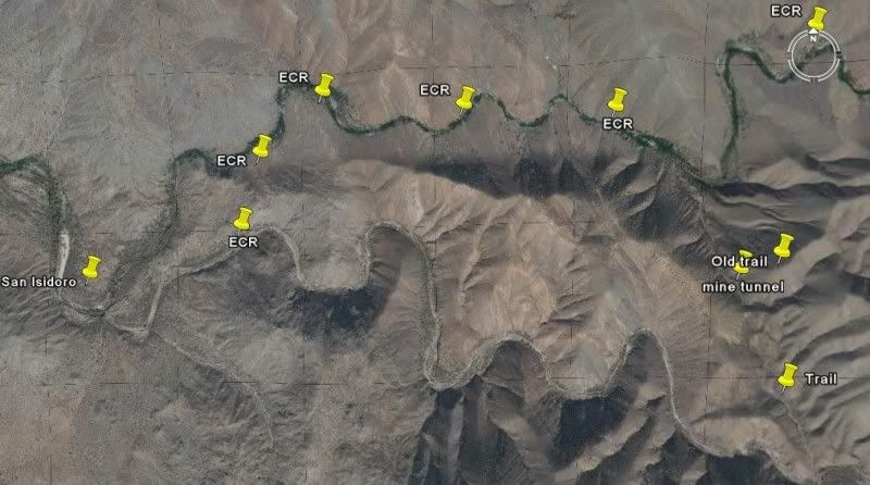
(Visita) SAN ISIDORO 30°45'55.17" 115°32'49.81" Located on the trail to Mision San Pedro Martir, several hours walk from the nearest road.
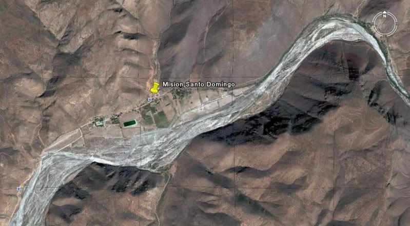
SANTO DOMINGO 30°46'15.20" 115°56'14.00" Located 5 miles east of Hwy. 1, just north of the Arroyo Santo Doming bridge, north of Colonia Vicente
Guerrero. Signed.
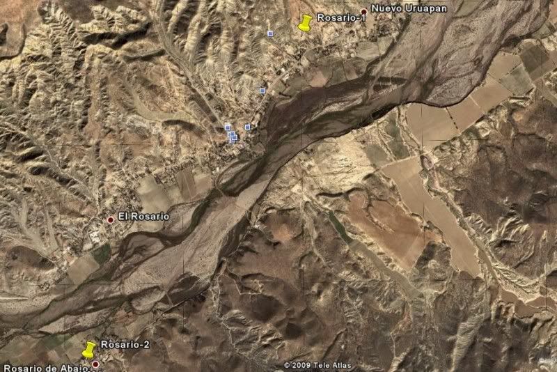
ROSARIO-1 30°04'01.00" 115°43'08.00" Located just off Hwy. 1 in El Rosario. Signed.
ROSARIO-2 30°02'29.00" 115°44'20.80" Located in the town of Rosario de Abajo, just over a mile from Hwy. 1.
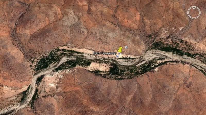
SAN FERNANDO VELICATA 29°58'16.52" 115°14'12.20" Located about 4 miles from Hwy. 1. Signed turnoff at Rancho Progreso.
(Visita) SAN JUAN DE DIOS 30°10'57.61" 115°10'04.50" Located above the east side of the arroyo, next to the road to Rancho El Metate, 22 miles from
Hwy. 1.
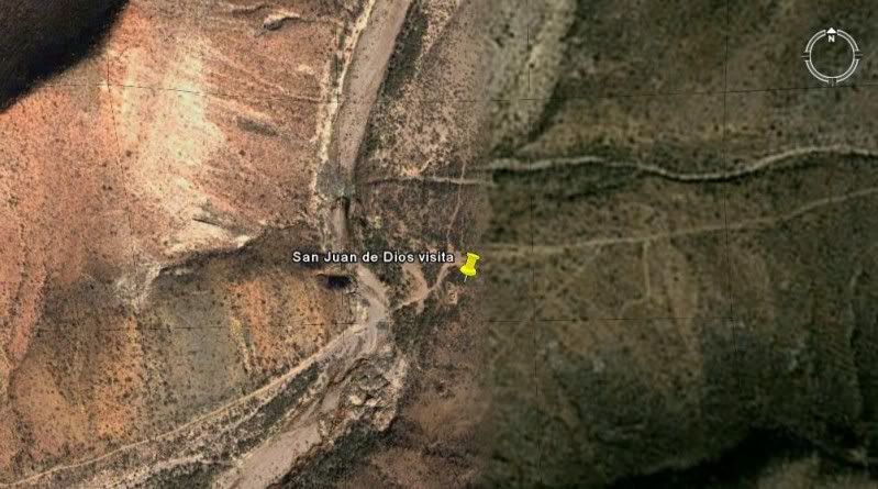
(note: site obliterated by a farmer in 2006. Now (2018) Rancho Las Palmas is near the site)
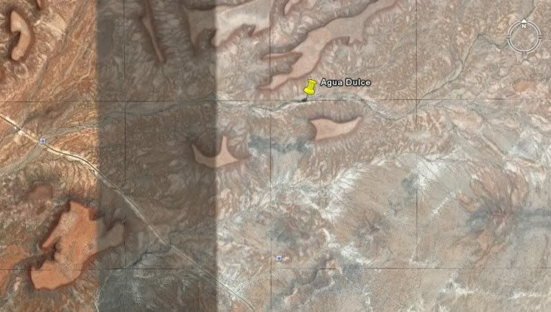
(Historic spring on El Camino Real) AGUA DULCE 29°52'58.70" 114°49'25.00" Located 2 miles east from Hwy. 1 at Km. 160-161.
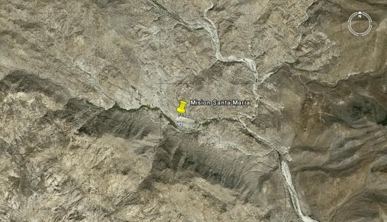
SANTA MARIA 29°43'54.50" 114°32'50.16" Located 14.5 miles from Rancho Santa Ynez over an extreme 4WD road.
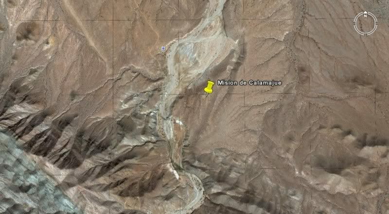
CALAMAJUE 29°25'16.30" 114°11'42.36" Located 15.5 miles north of Hwy. 1 (Km. 261) or 14 miles east and south of Coco's Corner, on the east bank of
Arroyo Calamajue.
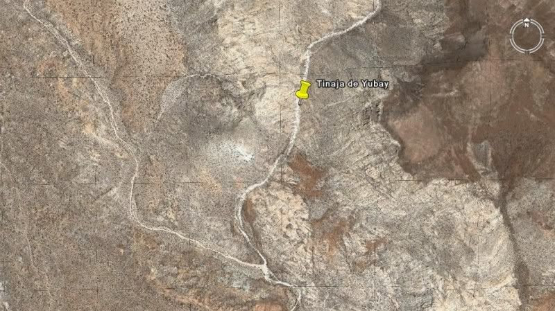
(Historic water hole near El Camino Real) TINAJA DE YUBAY 29°10'41.37" 113°59'15.20" Located north of the L.A. Bay highway off the road signed
'Rancho San Luis'.
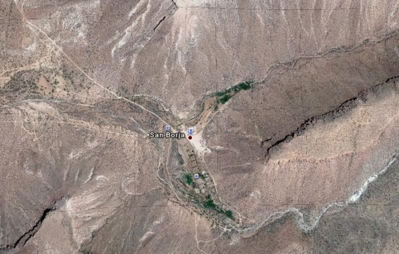
SAN BORJA 28°44'40.37" 113°45'14.39" Well signed 21 miles south of L.A. Bay highway or east of Hwy. 1 at Nuevo Rosarito.
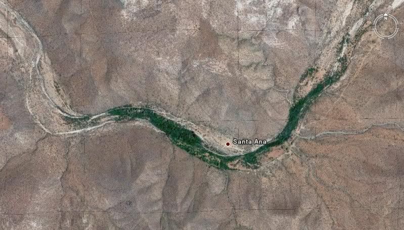
(Visita) SANTA ANA 28°41'25.23" 113°49'14.31" Located south of the San Borja/ Nuevo Rosarito road.
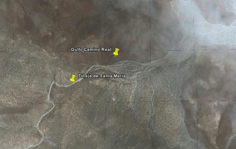
(Waterhole near Golfo Camino Real) TINAJA DE SANTA MARIA 28°26'05.20" 113°20'01.40" Located south from the old road to San Francisquito, south of
Bahia de los Angeles and just east of Rancho La Bocana (San Pedro).
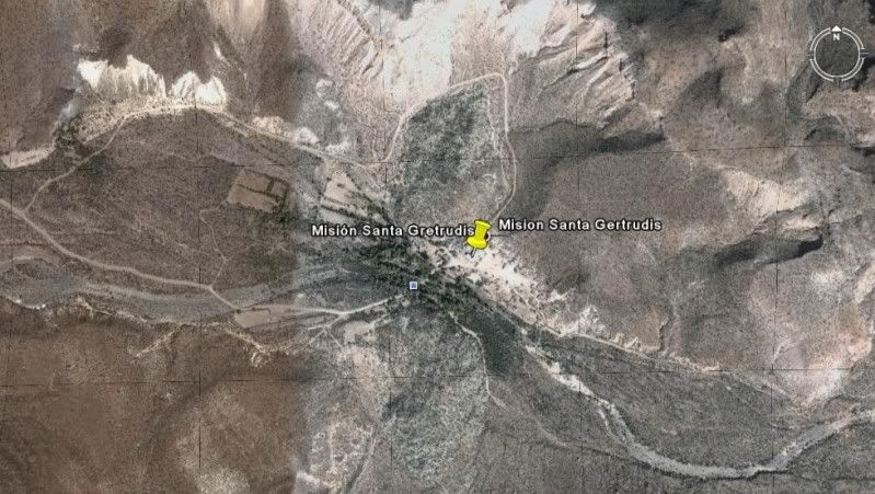
SANTA GERTRUDIS 28°03'04.02" 113°05'07.17" Access roads from El Arco, Guillermo Prieto and San Francisquito/ El Barril.
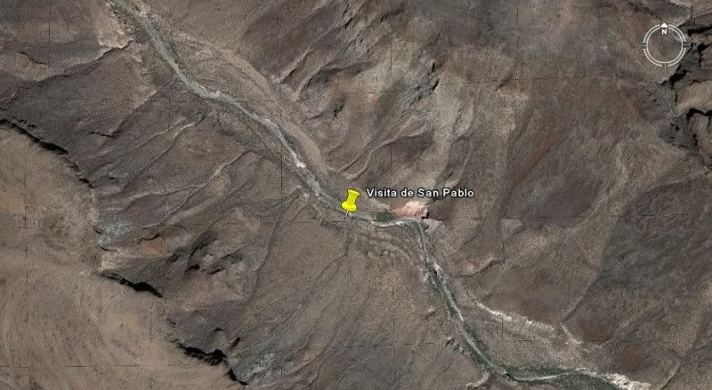
(Visita) SAN PABLO 27°42'07.81" 113°08'42.08" Located in San Pablo Canyon, east of Vizcaino. Access may be restricted without a guide.
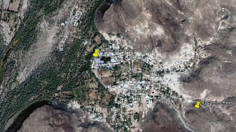
SAN IGNACIO 27°17'02.18" 112°53'56.12" Facing the town plaza of San Ignacio.
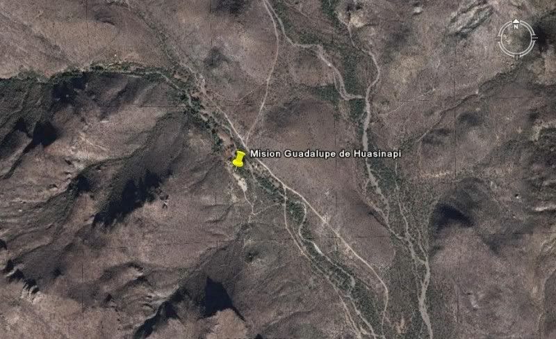
GUADALUPE 26°55'09.50" 112°24'20.60" Signed as the 'ex-mision' of Guadalupe, east of San Jose de Magdalena in the mountains northwest of Mulege.
Since 2014, only the south road out from Mulegé is passable and with several unlocked cattle control gates to pass through. NOTE: In 2017, I found
the church ruin a bit to the southwest of this waypoint and pin. The entire area is of interest with many stone walls and steps. The church wall is
uphill and slightly north of the modern cinder-block building at the end of the mission driveway (closed gate).
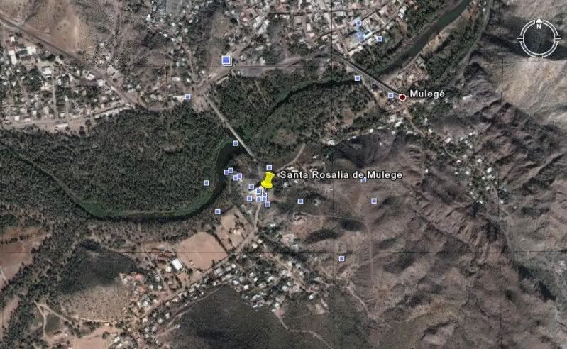
SANTA ROSALIA DE MULEGE 26°05'37.00" 111°59'09.30" On the south side of the river, just west of the highway bridge in Mulege.
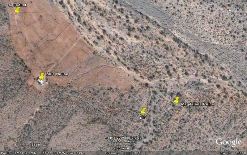
SAN JOSE DE MAGDALENA post-mission period church 27°03'40.33" 112°13'24.87" Just east of the town on the south side of the arroyo, north of Mulege.
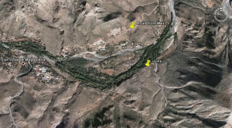
(Pila/ ag site for San Jose de Magdalena, misidentified as Mision Santa Maria Magdalena) 27°03'29.10" 112°10'12.34" Located just outside the canyon
'Boca de Magdalena' east of Palo Verde, north of Mulege. The stone building ruins are on both sides of the road at 27°03'29.90" 112°10'07.40", 4.6
miles from Hwy. 1 at Km.162.5 (take left road at mile 3.7). The stone ruins were obliterated by flash floods in 2014 as the riverbed widened into the
site.
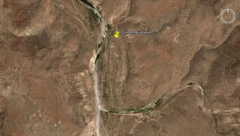
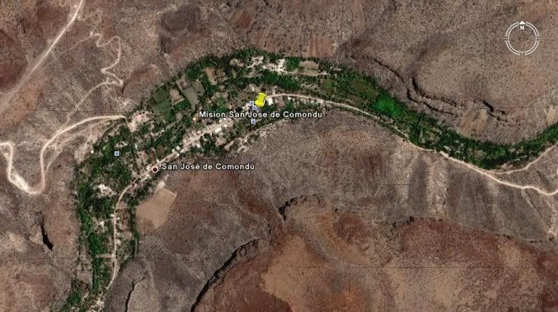
SAN JOSE DE COMONDU (1st site, 'Comondu Viejo') 26°16'27.40" 111°43'08.50" On the old transpeninsular road between ranchos of San Juan and La Presa.
Go 11 miles west of Hwy. 1 on the La Purisima road (south of Bahia Concepcion), then turn south for 9 miles. The site is 22 miles north of the town of
San Jose Comondu. The road is washed out 0.7 mile north of then site, just south of San Juan.
SAN JOSE DE COMONDU (final site) 26°03'34.59" 111°49'20.41" In the town of San Jose Comondu.
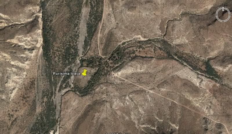
LA PURISIMA (1st possible site, 'Purisima Vieja') 26°18'34.48" 112°09'50.98" Located 16 miles north of San Isidro, 3.4 miles south of Paso Hondo.
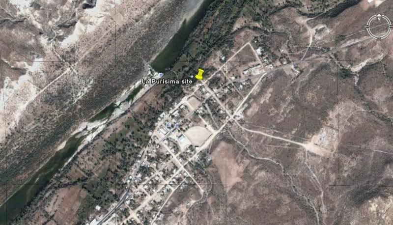
LA PURISIMA (final site) 26°11'25.60" 112°04'22.60" In the town of La Purisima.
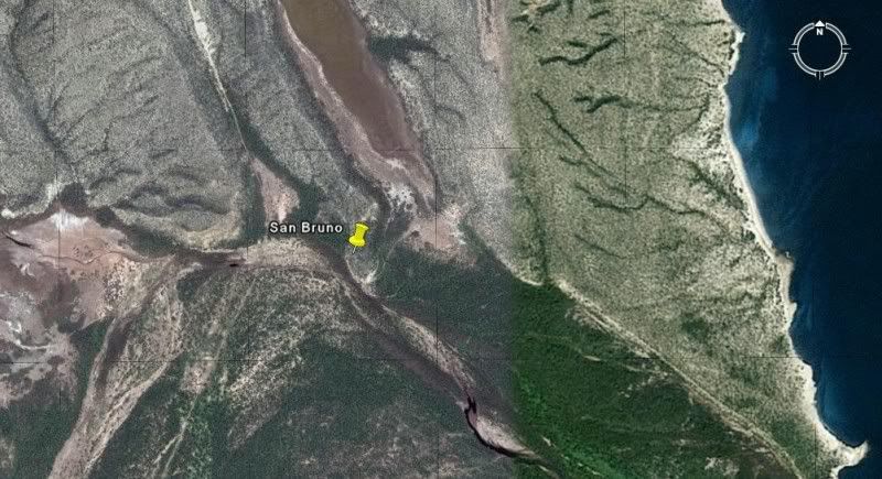
SAN BRUNO (1683-1685 colony site) 26°13'57.50" 111°23'53.90" 14 miles north of Loreto near, the coast on a hill.
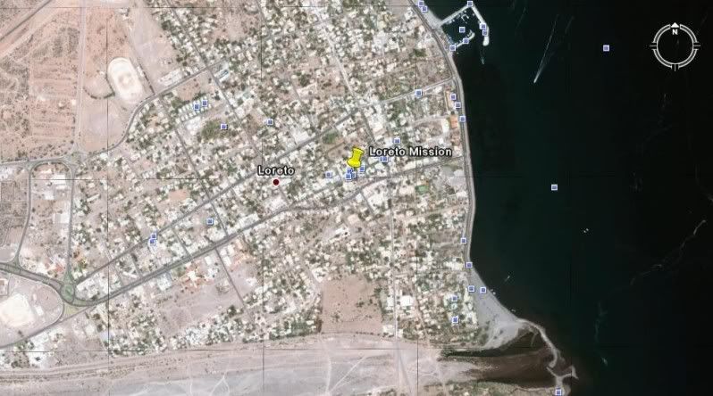
LORETO 26°00'37.00" 111°20'35.80" In the center of town.
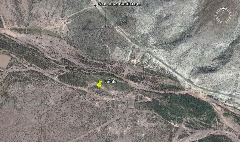
(Visita) SAN JUAN BAUTISTA LONDO 26°13'30.83" 111°28'24.51" About 17 miles north of Loreto and just west of Hwy. 1, next to a ranch. Ruins visible
from the highway.
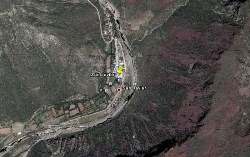
SAN JAVIER 25°51'36.86" 111°32'36.99" 22 miles west and south from Loreto, well signed.
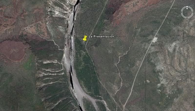
(Visita) LA PRESENTACION 25°43'45.00" 111°32'37.40" About 11 miles south of San Javier.
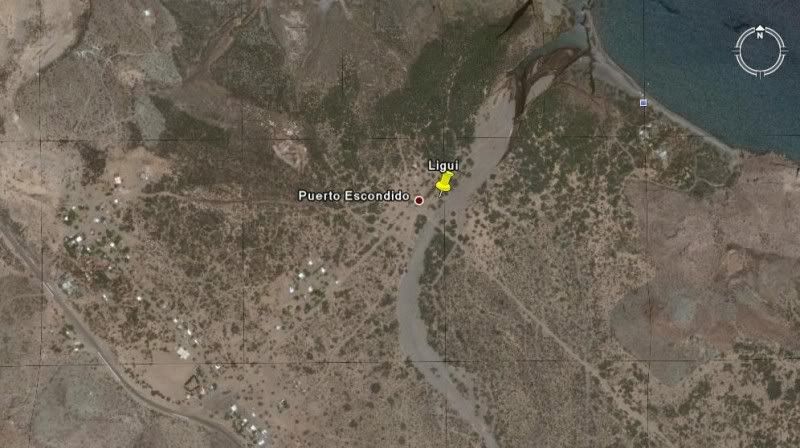
SAN JUAN BAUTISTA DE LIGUI/ DE MALIBAT 25°44'22.20" 111°15'51.00" (no remains, arroyo swallowed ruins in 2001) At the southeast junction of the road
to Playa Ligui and Ensenada Blanca, just east of Hwy. 1, nine miles south of Puerto Escondido.
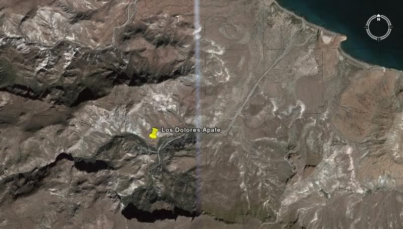
LOS DOLORES APATE 25°03'19.04" 110°53'03.33" Access by foot/ mule trail off road to Los Burros about 15 miles northeast of La Presa and Los Dolores
Chilla (La Pasion).
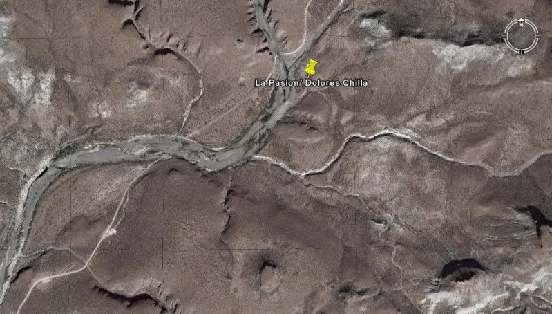
LOS DOLORES CHILLA (La Pasion) 24°53'14.4" 111°01'49.81" Just east of Rancho La Presa at Rancho La Capilla off the road to Los Burros, just west of
school village, Santa María de la Toris.
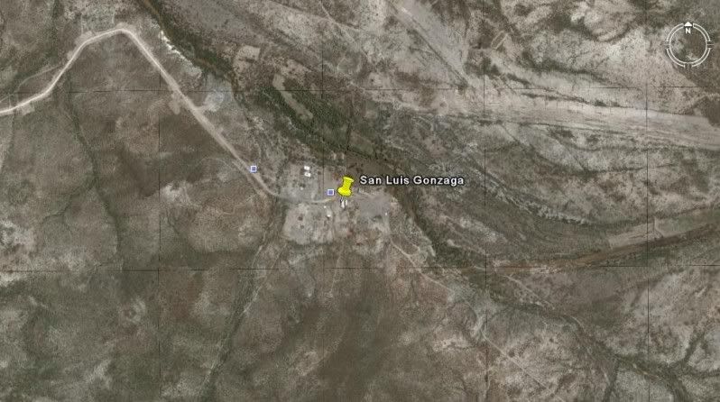
SAN LUIS GONZAGA 24°54'29.00" 111°17'27.25" Off the road to Presa el Ihuajal, 10 miles south of Ciudad Constitucion.
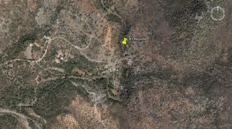
(Visita) EL NOVILLO 23°55'48.60" 110°13'28.20" (a post-mission chapel... Pin location and GPS from Jack Swords)
(Visita) ANGEL DE LA GUARDA (EL ZALATO) 23°53'27.60" 110°10'14.80" (a visita of the La Paz mission)
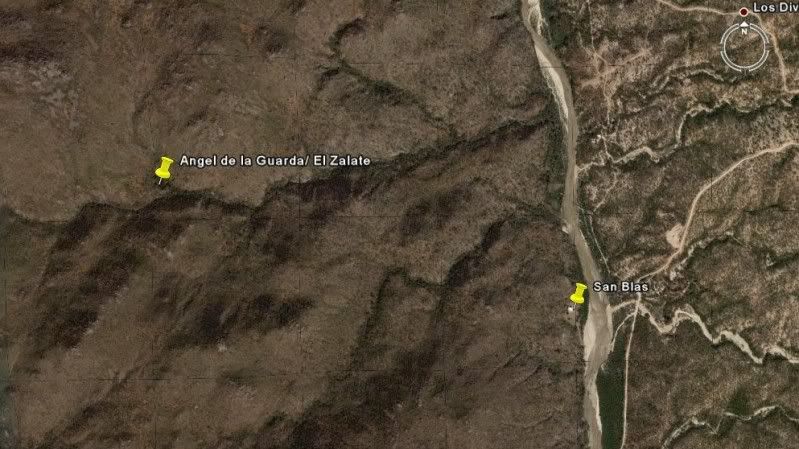
SAN BLAS (a church from the 1760's village) down the hill from El Zalato 23°53'10.40" 110°09'16.21"
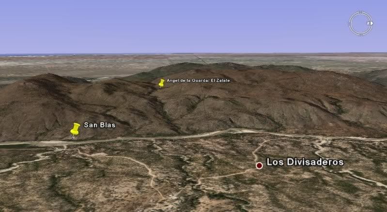
(view sideways and looking west)
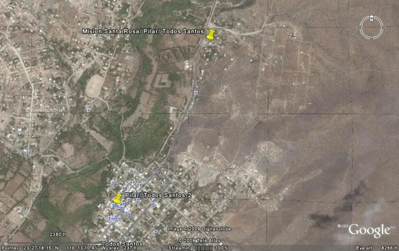
There are two mission sites for Todos Santos.
The first site began as a visita for the La Paz mission (named 'Todos Santos'), then became a separate mission named 'Santa Rosa de las Palmas'...
some stone walls are all that remain and a modern church is built on the site: 23°27'37.30" 110°13'08.31"]
The La Paz mission (Nuestra Señora del Pilar de la Paz) moved from the Bay of La Paz to Todos Santos and that ended the Santa Rosa mission...
The second site is the location of the modern town church of Todos Santos, where the mission moved. 23°26'59.16" 110°13'31.62"
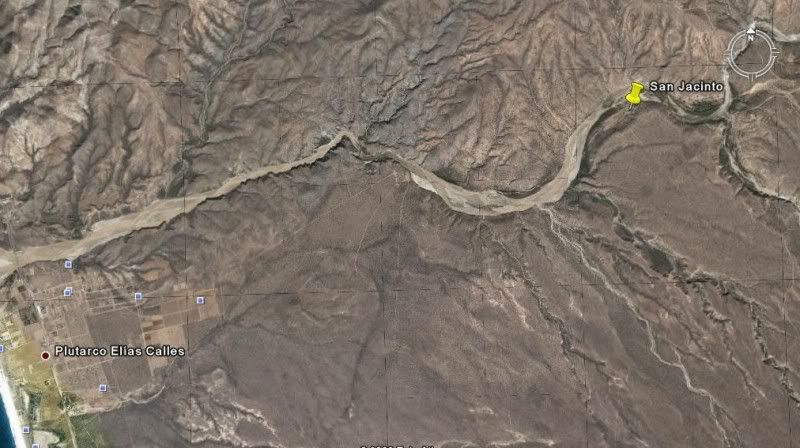
(Visita) SAN JACINTO 23°14'34.21" 110°04'37.20"
The original mission ruins for La Paz, Santiago, and San Jose del Cabo are not visible or have been built over by newer construction.
Details on the Baja missions: http://vivabaja.com/bajamissions
Enjoy the fascinating history of Old California! 
A NEW WEB PAGE HAS BEEN MADE SINCE POSTING THE ABOVE: http://vivabaja.com/missions4
[Edited on 3-23-2018 by David K]
|
|
|
Barry A.
Select Nomad
Posts: 10007
Registered: 11-30-2003
Location: Redding, Northern CA
Member Is Offline
Mood: optimistic
|
|
I am blown away, David. This is one incredible "post".
Thank you so much for all you great work.
Barry
|
|
|
David K
Honored Nomad
Posts: 64476
Registered: 8-30-2002
Location: San Diego County
Member Is Offline
Mood: Have Baja Fever
|
|
Thanks Barry... My web host has already started making the above into Part 4 of the revised missions and visitas... It needs some editing, but here is
a sneak peek!: http://vivabaja.com/missions4
|
|
|
David K
Honored Nomad
Posts: 64476
Registered: 8-30-2002
Location: San Diego County
Member Is Offline
Mood: Have Baja Fever
|
|
Remember, that in addition to the above mission sites from space images... I have also put together satellite images and maps of the EL CAMINO REAL
where it can be seen from above! The list of links to the many sections from Mision Santa Maria south to Loreto is on this page: http://vivabaja.com/missions2/page13.html
ENJOY!
|
|
|
David K
Honored Nomad
Posts: 64476
Registered: 8-30-2002
Location: San Diego County
Member Is Offline
Mood: Have Baja Fever
|
|
Why three missions are not included: The original mission ruins for La Paz, Santiago and San Jose del Cabo are not visible or have been built over by
newer construction.
The 1724 site for Santiago is on a private ranch and the owner does not want visitors, so Jack and I agree to not show the location but foundation
stones are there. In 1736, the mission was moved to where a modern church now stands, in the town of Santiago.
|
|
|
Jack Swords
Super Nomad
Posts: 1094
Registered: 8-30-2002
Location: Nipomo, CA/La Paz, BCS
Member Is Offline
|
|
Now THAT is impressive! You have been busy. Looking at the sites, I feel like I am back there with all the surroundings included. Brings back good
memories, thanks.
|
|
|
David K
Honored Nomad
Posts: 64476
Registered: 8-30-2002
Location: San Diego County
Member Is Offline
Mood: Have Baja Fever
|
|
| Quote: | Originally posted by Jack Swords
Now THAT is impressive! You have been busy. Looking at the sites, I feel like I am back there with all the surroundings included. Brings back good
memories, thanks. |
This was originally posted in 2009, but it is well worth a bump up every few years!
Like you Jack, I do what I can to keep the history alive and interesting... I look forward to when you find new sites or revisit the same ones
again... they ARE vanishing during our lifetimes... Ligui, San Juan de Dios are both gone... San Fernando is a fraction of its size when I first
camped there in 1974.
*Jack Swords is the primary photographer for our Baja Missions web pages and many of his photos are included in our 2012 Missions Book.
|
|
|
edm1
Senior Nomad
Posts: 568
Registered: 8-23-2006
Location: Oak Hills, Ca
Member Is Offline
|
|
For even greater clarity of photos, we need to bring the drone when we visit the missions, in particular, and even every adventure trip to take aerial
phots of where we've been.
|
|
|
shari
Select Nomad
Posts: 13033
Registered: 3-10-2006
Location: bahia asuncion, baja sur
Member Is Offline
Mood: there is no reality except the one contained within us "Herman Hesse"
|
|
thanks DAvid....that was really neat to see how they are situated on arroyos etc.
|
|
|
durrelllrobert
Elite Nomad
Posts: 7393
Registered: 11-22-2007
Location: Punta Banda BC
Member Is Offline
Mood: thriving in Baja
|
|
Does the NSA know you have these photos? An Al-queda terrorist could use them to blow up the missions.
Bob Durrell
|
|
|
Udo
Elite Nomad
Posts: 6321
Registered: 4-26-2008
Location: Black Hills, SD/Ensenada/San Felipe
Member Is Offline
Mood: TEQUILA!
|
|
Very informative, David.
The aerial views punctuate the locations very well, and it will make it easier to visit those locations with our Baja Missions, and Baja Almanac maps.
Mil Gracias!
Udo
Youth is wasted on the young!
|
|
|
David K
Honored Nomad
Posts: 64476
Registered: 8-30-2002
Location: San Diego County
Member Is Offline
Mood: Have Baja Fever
|
|
The GPS for each is included as well... it is at the Google Earth and standard GPS map datum setting of WGS84.
Most missions are well known and not hidden, but there are a few that make seeking them an adventure!
|
|
|
elgatoloco
Ultra Nomad
Posts: 4321
Registered: 11-19-2002
Location: Yes
Member Is Offline
|
|
Hat tip to science for making this all possible.............
MAGA
Making Attorneys Get Attorneys
|
|
|
gueribo
Nomad
Posts: 458
Registered: 10-16-2014
Member Is Offline
|
|
Very cool.
|
|
|
Bruce R Leech
Elite Nomad
Posts: 6796
Registered: 9-20-2004
Location: Ensenada formerly Mulege
Member Is Offline
Mood: A lot cooler than Mulege
|
|
thanks David
Bruce R Leech
Ensenada
 |
|
|
David K
Honored Nomad
Posts: 64476
Registered: 8-30-2002
Location: San Diego County
Member Is Offline
Mood: Have Baja Fever
|
|
My pleasure, Bruce!
I have just fixed the page symbols that got converted to black diamonds with a question mark inside. This happens when Doug does a page update for
Nomad and the software does not recognize degree symbols (°) or Spanish letters (ñ).
I also added a few notes on changes based on my recent visits to many of the mission locations.
|
|
|
fishbuck
Banned
Posts: 5318
Registered: 8-31-2006
Member Is Offline
|
|
That is cool. Very interesting. Thanks
"A ship in harbor is safe, but that is not what ships are built for." J. A. Shedd.
A clever person solves a problem. A wise person avoids it. – Albert Einstein
"Life's a Beach... and then you Fly!" Fishbuck
|
|
|
David K
Honored Nomad
Posts: 64476
Registered: 8-30-2002
Location: San Diego County
Member Is Offline
Mood: Have Baja Fever
|
|
My pleasure Mike!
|
|
|
fishbuck
Banned
Posts: 5318
Registered: 8-31-2006
Member Is Offline
|
|
Can I have another clue for this location?

"A ship in harbor is safe, but that is not what ships are built for." J. A. Shedd.
A clever person solves a problem. A wise person avoids it. – Albert Einstein
"Life's a Beach... and then you Fly!" Fishbuck
|
|
|
Jack Swords
Super Nomad
Posts: 1094
Registered: 8-30-2002
Location: Nipomo, CA/La Paz, BCS
Member Is Offline
|
|
The newest technology with drones (as suggested) would be quite an enhancement (and adventure).
|
|
|
| Pages:
1
2 |