David K
Honored Nomad

Posts: 65106
Registered: 8-30-2002
Location: San Diego County
Member Is Offline
Mood: Have Baja Fever
|
|
SEE BAJA LOCATIONS FROM SPACE
This is a re-post of the work on Nomad I did beginning back in May of 2005, providing links to specific spots on the peninsula... on Google Satellite
Maps. It is more fun than work, by-the-way!
Click on the location link, make the page full size for better viewing and then you can use your mouse to scroll off the image and see the surrounding
area, zoom out for a bigger area view... and even zoom in closer on some!
Now, some of the links may need fixing after all these years and earth movements (lol), let me know!
IF you would like a place added to this list, let me know!
1) BAJA PACIFIC COAST:
La Bufadora, Punta Banda
Punta Cabras
Punta Colonet
Bahia de San Quintin
Punta Baja
Punta San Carlos
Punta Canoas
Punta Vibora
Punta Blanco
Punta Cono
Punta Maria
Escalera Nautica at Santa Rosalillita]
El Tomatal & Miller's Landing
Morro Santo Domingo & Laguna Manuela
Laguna Guerrero Negro (Black Warrior)
Laguna Ojo de Liebre (Scammon's Lagoon)
Bahia Tortugas
San Roque
Bahia Asuncion
Punta Abreojos
San Juanico/ Scorpion Bay
Puerto Lopez Mateos, Mag Bay
Puerto San Carlos, Mag Bay
Puerto Cancun, Mag Bay
Punta Conejo
Cabo San Lucas
===================================================
BAJA GULF COAST:
San Felipe
Punta Estrella
Rancho/Laguna Percebu & north end of Shell Island
Bahia Santa Maria, south of San Felipe
El Coloradito
Punta San Fermin
Puertecitos
Isla El Huerfanito (The Little Orphan) and Nacho's Camp
Gonzaga Bay (Punta Willard to Punta Final)
Puerto Calamajue
End of new track to coast (so. of Calamajue)
Punta Remedios, Bahia Guadalupe
Bahia de los Angeles
Punta San Francisquito
La Trinidad
Santa Rosalia
Mulege
Santispac to Coyote, Bahia Concepcion
El Requeson, Bahia Concepcion
Loreto
Puerto Escondido
Agua Verde
Timbabichi
Los Burros and Valle Kakiwi lake
San Evaristo, Valle el Venado lake, Isla San Jose's Punta San Ysidro
San Juan de la Costa
El Magote, Ensenada de Aripes, El Centenario, part of La Paz
Pichilingue (ferry terminal)
Las Arenas, Ensenada de los Muertos
Los Barriles
La Ribera
Cabo Pulmo and Los Frailes
Estero San Jose, San Jose del Cabo
See Pacific Coast list for Cabo San Lucas
===================================================
ALONG HWY. 1 (within 6 miles):
Tijuana Border Crossing
Popotla (Fox Studios to Punta el Descanso)
San Pedro Martir/ Observatory Road Jcn.
San Telmo de Arriba (on Observatory road)
Turnoff to Punta San Carlos (Km. 80-81)
Rancho El Arenoso (abnd.)
Mision San Fernando access at Hwy. 1
El Progreso (on Hwy. 1), signed access to San Fernando
Mision San Fernando
San Agustin (Abdn. Pemex, trailer park)
El Marmol Road at Hwy. 1 (next to Cafe Sonora)
Arroyo Agua Dulce & 1973 water truck access road at Hwy. 1
Agua Dulce (historic spring on El Camino Real)
New/good access to Agua Dulce
Old Southern road to/from El Marmol at Old Main Baja Road
Agua Escondida access (?) at old Baja road
Faro San Jose Road at Hwy. 1
Catavina Rock Art Site (near Hwy. 1 at north arroyo crossing)
Catavina
Laguna Chapala
Turnoff to San Antonio & Pacific Coast
El Crucero (old San Felipe & Gonzaga road jcn. with Mex. 1)
Old L.A. Bay Road crossing Hwy. 1, New Rancho San Luis road jcn.
Shortcut road to San Antonio (Codornices) at Hwy. 1
L.A. Bay Hwy. Jcn. (ex-Parador Punta Prieta)
Punta Prieta (old dirt strip upper left & paved runway lower right)
Turnoff to Santa Roaslillita & paved part of Escalera Nautica highway
(Nuevo) Rosarito, road east to San Borja
Turnoff to El Tomatal
Villa Jesus Maria, road to Laguna Manuela
Eagle Monument, Guerrero Negro
Turnoff to El Arco
Turnoff to Guillermo Prieto, Mision Santa Gertrudis, Punta San Francisquito
Vizcaino, Turnoff to Bahia Tortugas
Turnoff to San Francisco de la Sierra
Turnoff to Punta Abreojos
San Ignacio
San Bartolo
Santiago
Agua Caliente (near Santiago)
Miraflores
=============================================
MISC. BAJA LOCATIONS:
Tijuana/Tecate Toll Gate & Blvd. 2000 Jcn.
Tecate Border Crossing
Laguna Salada Road at Mexico #2
Guadalupe Canyon
Colorado River (near gulf)
Ojos Negros
Laguna Hanson
Mike's Sky Rancho Jcn., Hwy. 3
San Matias Pass, Hwy. 3
Crucero La Trinidad (Hwy. 5 & Hwy. 3 Jcn.)
Mike's Sky Rancho
Meling Ranch
Observatorio
Diablo Mountain & Canyon
San Isidoro
Trail to San Pedro Martir from San Isidoro
Mision San Pedro Martir
San Felipe Airport
Sulfur Mine (El Apache)
Agua Caliente Canyon (off Valle Chico)
Agua Caliente Hot Spring
Rancho el Matomi (west of Puertecitos)
Mine west of Puertecitos, at end of long road from Mex. 1
Rancho San Antonio
El Marmol (onyx school house)
El Volcan
Peninsular Divide, Mision Santa Maria Road
Mision Santa Maria de los Angeles
Las Arrastras (site)
Pioneer Mine
Coco's Corner
Calamajue Mission Site
Tinaja de Yubay
El Toro Copper Mine
Mision San Borja
El Camino Real switchback
Las Flores Railroad, south end
Rancho La Bocana, south of L.A. Bay (called 'San Pedro' in Almanac)
El Arco
Guillermo Prieto (north of Vizcaino)
Geothermal Plant N of Santa Rosalia
Todos Santos
MORE TO COME?
[Edited on 2-3-2010 by David K]
|
|
|
David K
Honored Nomad
Posts: 65106
Registered: 8-30-2002
Location: San Diego County
Member Is Offline
Mood: Have Baja Fever
|
|
A list of links to see the Jesuit EL CAMINO REAL from space is on this page:
http://vivabaja.com/missions2/page13.html
Mission sites from space are all on this page: http://vivabaja.com/missions4/
|
|
|
BajaSerg
Nomad
Posts: 182
Registered: 3-31-2008
Location: Los Angels/Rosarito
Member Is Offline
Mood: Happy
|
|
Cool I can see my house 
|
|
|
David K
Honored Nomad
Posts: 65106
Registered: 8-30-2002
Location: San Diego County
Member Is Offline
Mood: Have Baja Fever
|
|
In 2005, when this project began, there were many parts of Baja that didn't have high resolution photos of... the biggest things like houses would be
fuzzy. While other areas you could see cars on the road and houses were sharp.. even palm trees could be seen. Now, much more of Baja is in the higher
resolution.
What is fun is to find dirt roads and follow them... You can record the GPS waypoints from Google and enter them into your GPS to find and follow
those roads you saw from space when you are down there.
|
|
|
larryC
Super Nomad
Posts: 1497
Registered: 8-11-2008
Location: BoLA
Member Is Offline
|
|
David
Thanks for all that. I have been useing G-earth for that very same reason in the El Arco area. There are really alot of ranchos and what look like
abandoned mines out in that area that I want to explore more this year. You got me going again.
Larry
|
|
|
David K
Honored Nomad
Posts: 65106
Registered: 8-30-2002
Location: San Diego County
Member Is Offline
Mood: Have Baja Fever
|
|
| Quote: | Originally posted by larryC
David
Thanks for all that. I have been useing G-earth for that very same reason in the El Arco area. There are really alot of ranchos and what look like
abandoned mines out in that area that I want to explore more this year. You got me going again.
Larry |
That is a great area for exploring! Have you seen Jack Sword's photos at http://vivabaja.com/swords ? He has a couple taken at Calmalli, just north of El Arco.
[Edited on 10-2-2009 by David K]
|
|
|
David K
Honored Nomad
Posts: 65106
Registered: 8-30-2002
Location: San Diego County
Member Is Offline
Mood: Have Baja Fever
|
|
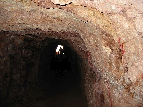
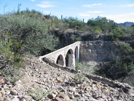
Another of Jack Swords' photos of Baja historic locations:
|
|
|
bajarhino
Newbie
Posts: 4
Registered: 9-13-2009
Member Is Offline
|
|
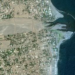
San Felipe from space
I checked out the San Felipe map, and yes it does show houses, landmarks, etc. BUT, they are about three years old. I see my house but it isn't
completed, which happened about three years ago. SO, this is great for overall landmarks, but not so great to see up to date photos. It's free, what
do you want!
|
|
|
Howard
Super Nomad
Posts: 2353
Registered: 11-13-2007
Location: Loreto/Manhattan Beach/Kona
Member Is Offline
Mood: I'd rather regret the things I've done than regret the things I haven't done.
|
|
Hi David
I went to the map in Loreto where my proporties are, found them, tried to print and it would only print a basic grid map showing where the streets are
with no other print. How do you print exactly what I see on the screen?
One of these days I am going to take you up on your offer on walking me through, step by step, on how to put pictures on this web site!
Howard
We don't stop playing because we grow old;
we grow old because we stop playing
George Bernard Shaw
|
|
|
David K
Honored Nomad
Posts: 65106
Registered: 8-30-2002
Location: San Diego County
Member Is Offline
Mood: Have Baja Fever
|
|
| Quote: | Originally posted by Howard
Hi David
I went to the map in Loreto where my proporties are, found them, tried to print and it would only print a basic grid map showing where the streets are
with no other print. How do you print exactly what I see on the screen?
One of these days I am going to take you up on your offer on walking me through, step by step, on how to put pictures on this web site!
Howard |
Get relaxed, and just be patient trying different things... Open a FREE Photobucket.com account. I have posted many times how to post photos on
Nomad... it is in the Baja Photos forum on Nomad.
The Google Earth images are a bit more work...
Here is Loreto, a bit closer than the link on my list...
|
|
|
Bajahowodd
Elite Nomad
Posts: 9274
Registered: 12-15-2008
Location: Disneyland Adjacent and anywhere in Baja
Member Is Offline
|
|
Thanks for the great work, David. It is true that the Google folks apre continually updating their stuff. I think folks have to understand how huge
this prject is, especially the street level stuff. I don't know what the priorities are at Google. But I was struck by the fact that I could find much
greater resolution viewing a cruise ship docked at Dobrovnik, Croatia than when I viewed Guerrero Negro.
|
|
|
noproblemo2
Super Nomad
Posts: 1088
Registered: 4-14-2006
Member Is Offline
|
|
You have an incredible amount of talent.. Thanks for sharing...S.
|
|
|
David K
Honored Nomad
Posts: 65106
Registered: 8-30-2002
Location: San Diego County
Member Is Offline
Mood: Have Baja Fever
|
|
De nada guys... happy to help keep the Baja exploration energy flowing!
|
|
|
David K
Honored Nomad
Posts: 65106
Registered: 8-30-2002
Location: San Diego County
Member Is Offline
Mood: Have Baja Fever
|
|
Please post your requests for more locations!
If you can't be there... at least you can look at it from above!
|
|
|
BAJACAT
Ultra Nomad
Posts: 2902
Registered: 11-21-2005
Location: NATIONAL CITY, CA
Member Is Offline
|
|
SANTA MARIA DE LOS ANGELES MISSION
BAJA IS WHAT YOU WANTED TO BE, FUN,DANGEROUS,INCREDIBLE, REMOTE, EXOTIC..JUST GO AND HAVE FUN.....
|
|
|
David K
Honored Nomad
Posts: 65106
Registered: 8-30-2002
Location: San Diego County
Member Is Offline
Mood: Have Baja Fever
|
|
| Quote: | Originally posted by BAJACAT
SANTA MARIA DE LOS ANGELES MISSION |
It is not in the higer resolution area, but I made this link which is 5 miles from the mission where the high resolution ends... "Peninsular Divide,
Mision Santa Maria Road"
I will make one at the mission, regardless... stand by!
Here is right over the mission: Mision Santa Maria de los Angeles
[Edited on 2-3-2010 by David K]
|
|
|
David K
Honored Nomad
Posts: 65106
Registered: 8-30-2002
Location: San Diego County
Member Is Offline
Mood: Have Baja Fever
|
|
Okay, the mission is added to the list! (Miscl. Baja locations)
|
|
|


