| Pages:
1
2 |
bajaamy
Newbie
Posts: 23
Registered: 10-29-2008
Member Is Offline
|
|
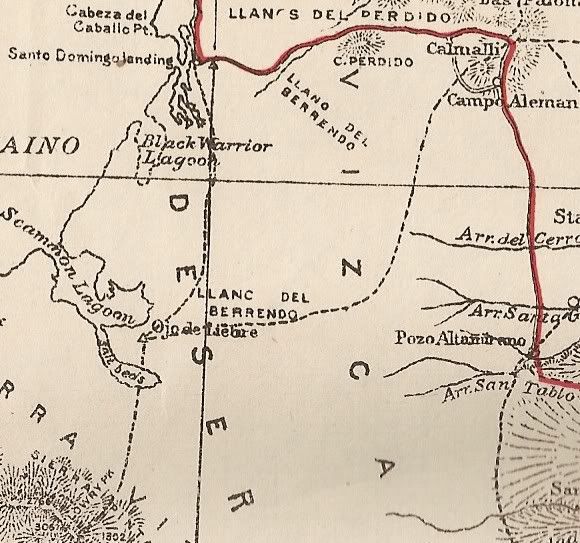
Well at Ojo Liebre
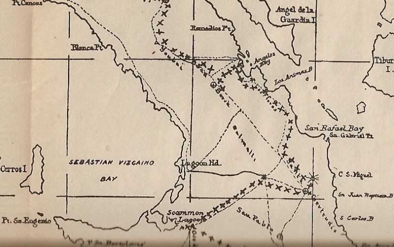
Does anyone (hello, David!) know exactly where the well at Ojo Liebre was that Arthur North talks about in his Camp and Camino book (p 146)?
His party had gone southwest from Calmalli, stopped at this well, and then headed southeast toward San Angel. Unfortunately they missed this second
water stop and almost died before reaching San Ignacio.
From the well at Ojo Liebre, they mucked around in the salt flats and noticed "Black Warrior" Lagoon (GN) in the distance. Can anyone pinpoint where
the actual well was?
|
|
|
David K
Honored Nomad

Posts: 64478
Registered: 8-30-2002
Location: San Diego County
Member Is Offline
Mood: Have Baja Fever
|
|
YES... a Nomad even went there recently and photographed it... I will try and dig it up... GPS, etc. (it is not easy to find today, but it is this
spring that gave the lagoon its Spanish name)...
|
|
|
David K
Honored Nomad
Posts: 64478
Registered: 8-30-2002
Location: San Diego County
Member Is Offline
Mood: Have Baja Fever
|
|
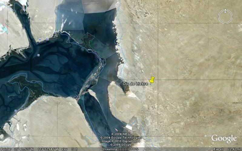
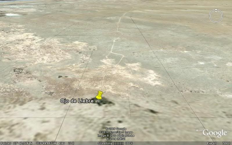
Okay Amy... I found the GPS for Ojo de Liebre. It is a spring not a well, by-the-way. This is thanks to Chris who found it last March. Howard Gulick
went there 50 years ago and took a photo. Chris reports more vegetation today.
NAD27Mexico for Ojo de Liebre is 27°40.659', -113°49.849'
WGS84 in the degrees, minutes, seconds format: 27°40'40.4" -113°49'53.3" (Google Earth uses WGS84)
On the Baja Almanac, this is very near 'El Huizache', just east of Scammon's Lagoon (Laguna Ojo de Liebre).
I will dig up the old photo and the Google image of it.
[Edited on 4-4-2017 by David K]
|
|
|
David K
Honored Nomad
Posts: 64478
Registered: 8-30-2002
Location: San Diego County
Member Is Offline
Mood: Have Baja Fever
|
|
from space and maps:
2003 map:
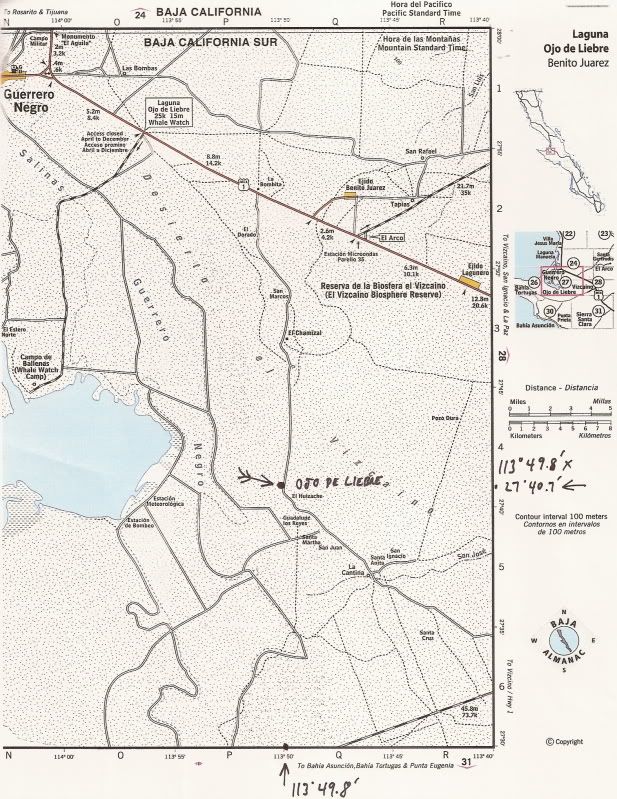
1975 map:
1962 map:
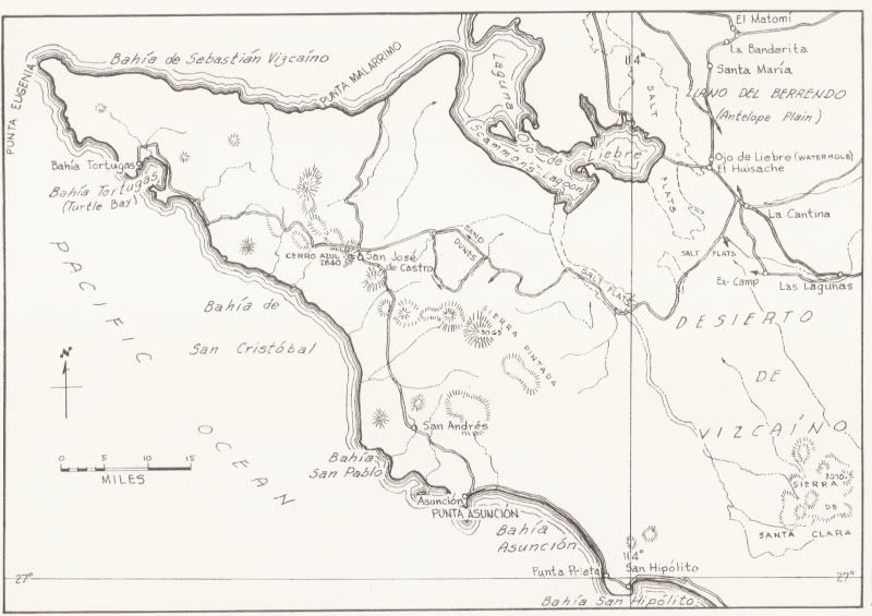
1941 map:
1907 (North) map:
1905 Nelson trip map (1919 pub.):
AAA 2003/2007 Map of area:
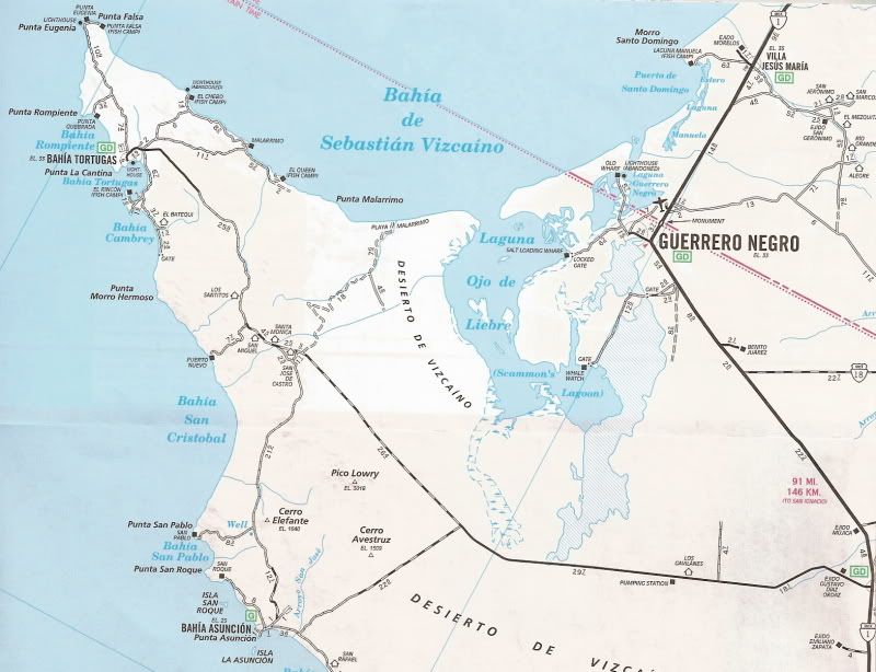
[Edited on 1-21-2010 by David K]
|
|
|
David K
Honored Nomad
Posts: 64478
Registered: 8-30-2002
Location: San Diego County
Member Is Offline
Mood: Have Baja Fever
|
|
Ojo de Liebre on May 1, 1961
http://libraries.ucsd.edu/speccoll/baja/gulick/images/m91-46...

[Edited on 12-28-2012 by David K]
|
|
|
David K
Honored Nomad
Posts: 64478
Registered: 8-30-2002
Location: San Diego County
Member Is Offline
Mood: Have Baja Fever
|
|
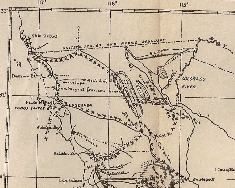
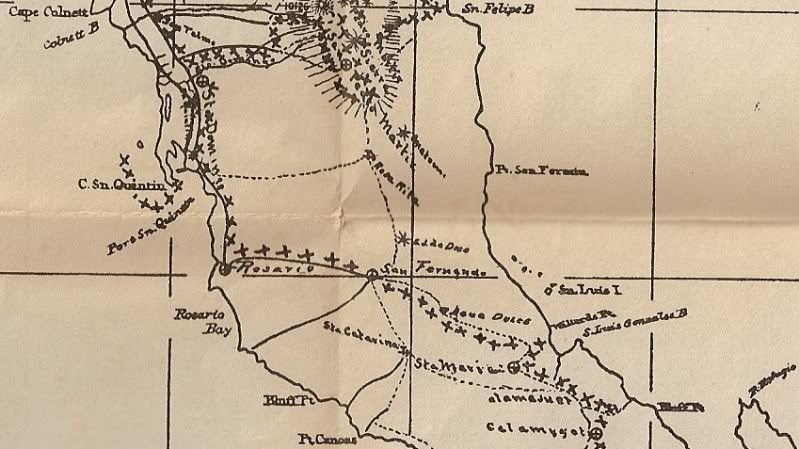
Camp and Camino in Lower California... both the original 1910 book and the 1977 reprint have the map. I have it scanned as well... Here is a post of
that book and map: http://forums.bajanomad.com/viewthread.php?tid=35278
Let me know if you want close ups on that map posted here.
[Edited on 1-21-2010 by David K]
|
|
|
David K
Honored Nomad
Posts: 64478
Registered: 8-30-2002
Location: San Diego County
Member Is Offline
Mood: Have Baja Fever
|
|
| Quote: | Originally posted by bajaamy
Thanks, David. My book is the bright-yellow no-frills reprint (sans map!) I'd love some high-quality close-ups if you don't mind.
|
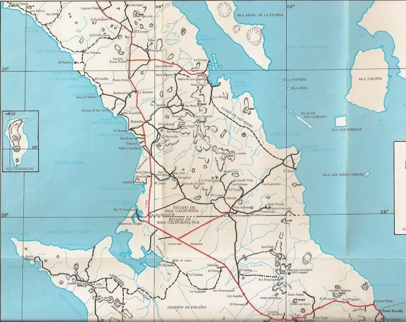
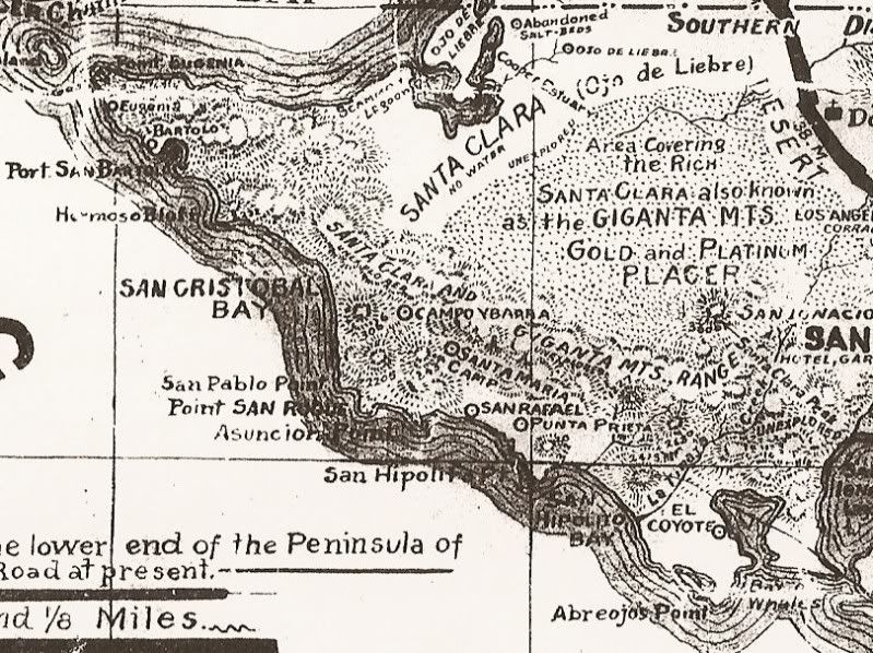
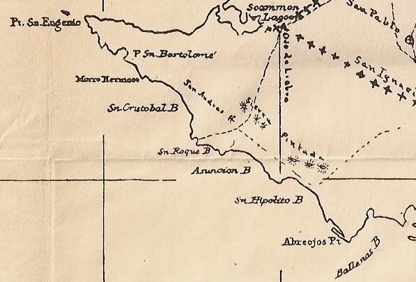
From north to south (drawn my Arthur North showing his travel route through Baja in 1905-06:
|
|
|
David K
Honored Nomad
Posts: 64478
Registered: 8-30-2002
Location: San Diego County
Member Is Offline
Mood: Have Baja Fever
|
|
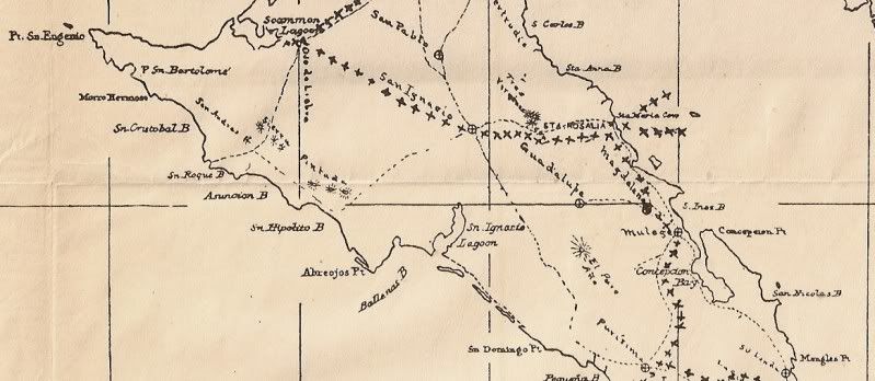
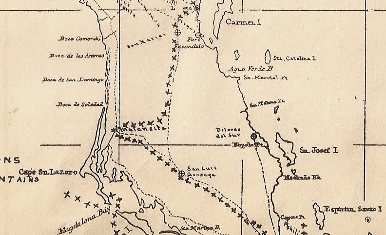
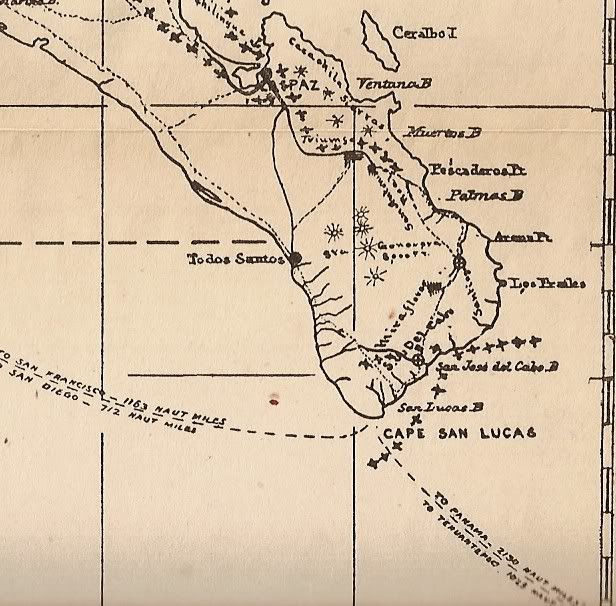
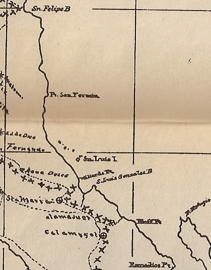
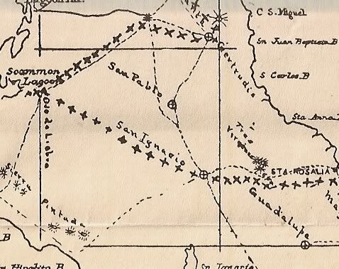
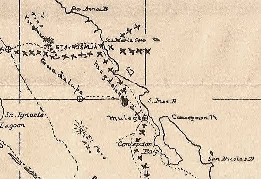
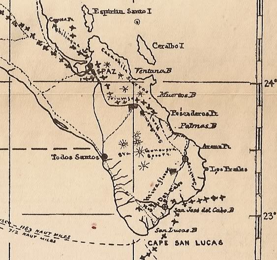
Some selected close ups:
Gonzaga Bay area:
Bahia Asuncion area:

San Pablo/ Ojo de Liebre/ San Ignacio area:
Mulege/Magdalena area:
Cape area:
|
|
|
fishbuck
Banned
Posts: 5318
Registered: 8-31-2006
Member Is Offline
|
|
DavidK, I still not sure where it is. Could you please post another 20 or 30 maps for me?
"A ship in harbor is safe, but that is not what ships are built for." J. A. Shedd.
A clever person solves a problem. A wise person avoids it. – Albert Einstein
"Life's a Beach... and then you Fly!" Fishbuck
|
|
|
desertcpl
Super Nomad
Posts: 2394
Registered: 10-26-2008
Location: yuma,az
Member Is Offline
|
|
DK
neat maps
could you give us a brief summary of his trip,, how long did it take him,, was they on horse back? etc
|
|
|
David K
Honored Nomad
Posts: 64478
Registered: 8-30-2002
Location: San Diego County
Member Is Offline
Mood: Have Baja Fever
|
|
I highly recommend you read his book(s)... 'Mother of California' is the other one! Your library should be able to get a copy of Camp and Camino if
they don't have one.
He and is party were on muleback (horses are no good on the El Camino Real in many places were there are drop offs)... and the trip was over several
months in 1905-06. The book has many photos... I used some of them in my Baja Mission web page...
La Purisima in 1906:

[Edited on 1-22-2010 by David K]
|
|
|
David K
Honored Nomad
Posts: 64478
Registered: 8-30-2002
Location: San Diego County
Member Is Offline
Mood: Have Baja Fever
|
|
How about in the past 7+ years: any new visits to Ojo de Liebre spring?
|
|
|
shari
Select Nomad
Posts: 13033
Registered: 3-10-2006
Location: bahia asuncion, baja sur
Member Is Offline
Mood: there is no reality except the one contained within us "Herman Hesse"
|
|
I would love to try to find it...David thanks for the maps...it was interesting that there was a trail from San Roque(near Asuncion) to the lagoon. So
the NAD27 coordinates are what we would use on our GPS???
|
|
|
David K
Honored Nomad
Posts: 64478
Registered: 8-30-2002
Location: San Diego County
Member Is Offline
Mood: Have Baja Fever
|
|
Quote: Originally posted by shari  | | I would love to try to find it...David thanks for the maps...it was interesting that there was a trail from San Roque(near Asuncion) to the lagoon. So
the NAD27 coordinates are what we would use on our GPS??? |
The datum is how the map is drawn. The Mexican topos were drawn to NAD27 Mexico. Google Earth, Geocaching, and standard factory settings on GPS units
are all set to WGS84.
Unless you are using a large scale topo, just staying at WGS84 is fine. In fact, the two points are usually withing shouting distance of each other!
If you get a GPS number (waypoint) that is at NAD27, simple change your GPS to NAD27, enter the waypoint, then change it back to WGS84. Either way, if
entered correctly, the GPS will take you to the point. What it is in longitude and latitude numbers will be slightly different, but probably only 100
meters or less apart on the ground.
My Viva Baja GPS list: http://www.vivabaja.com/GPS/ was made about 15 years ago, and per Neal Johns recommendation, I used NAD27 (because the Mexican topos / Baja
Almanac were drawn at that datum). Google Earth being at WGS84 has become the prime Baja location map for many, so that is why I am posting all new
GPS figures at that datum. Maybe, someday, I will convert my Viva Baja GPS list to WGS84?
|
|
|
PaulW
Ultra Nomad
Posts: 3005
Registered: 5-21-2013
Member Is Offline
|
|
David,
When one needs to convert a lot coords for a new datum see if this link makes it easier than using the GPS
http://tagis.dep.wv.gov/convert/
PW
|
|
|
BajaBlanca
Select Nomad
Posts: 13165
Registered: 10-28-2008
Location: La Bocana, BCS
Member Is Offline
|
|
thanks for all those maps! I love each and every one of them! La Bocana doesn't appear anywhere LOL
What an amazing journey this must have been- golly gosh.
Again, thanks so much for taking the time to post the various maps.
great thread you started bajaamy.
|
|
|
David K
Honored Nomad
Posts: 64478
Registered: 8-30-2002
Location: San Diego County
Member Is Offline
Mood: Have Baja Fever
|
|
La Bocana, as a village is newer than most of those maps. Ojo de Liebre is an important source of life in a vast desert with few sources of water.
An interesting note on La Bocana is that Antonio's (BajaCactus) father was the school principal there and where he met the future mother of
BajaCactus.
[Edited on 5-14-2017 by David K]
|
|
|
mtgoat666
Select Nomad
Posts: 17289
Registered: 9-16-2006
Location: San Diego
Member Is Offline
Mood: Hot n spicy
|
|
Speaking of wells, Any of you wandering nomads seen any chain pumps in your nomadic wandering? Curious to know if any still in use. I don't recall
seeing any, but suspect there are many still about.
Also, for you engineers, what is Spanish word for "chain pump" used for wells?
|
|
|
gsbotanico
Nomad
Posts: 209
Registered: 7-28-2015
Location: Cardiff by the Sea, CA
Member Is Offline
|
|
| Quote: Originally posted by mtgoat666 | Speaking of wells, Any of you wandering nomads seen any chain pumps in your nomadic wandering? Curious to know if any still in use. I don't recall
seeing any, but suspect there are many still about.
Also, for you engineers, what is Spanish word for "chain pump" used for wells? |
I've never heard a discussion in Spanish of a chain pump. I would guess it would be "bomba de cadena," a literal translation. Perhaps adding
"...para agua de pozo" would clarify it. If there is a word, I would like to know what it is.
And thanks for the maps, David. I enjoyed looking at them all.
[Edited on 5-15-2017 by gsbotanico]
|
|
|
David K
Honored Nomad
Posts: 64478
Registered: 8-30-2002
Location: San Diego County
Member Is Offline
Mood: Have Baja Fever
|
|
De nada... if you would like to see more, let me know what area of Baja or what year map is of interest to you. I have hundreds of scanned maps of
Baja and they are all online for anyone to see. 
|
|
|
| Pages:
1
2 |


