| Pages:
1
2 |
David K
Honored Nomad

Posts: 64493
Registered: 8-30-2002
Location: San Diego County
Member Is Offline
Mood: Have Baja Fever
|
|
TINAJA DE YUBAY (photos, directions, satellite images, old maps))
The historic water hole is along the Camino Real between San Borja and Calamajue. Today access is from the Bahia de los Angeles highway, just over 7
miles east of Hwy. 1.
From the VivaBaja GPS web page:
Side trip to Tinaja de Yubay (map datum NAD 27 Mexico) WGS84 waypoints are below the photos....
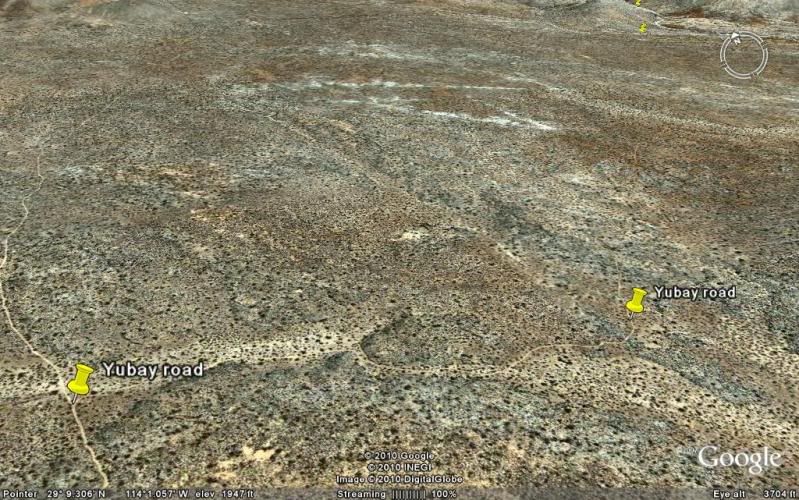
Turn north off L.A. Bay Hwy. (7 mi. E of Hwy. 1, near Km.11), signed Rcho. San Luis: 29°04.30'/ 114°02.37'
Jcn. with old L.A. Bay road, go left/ west: 29°06.34'/ 114°01.25'
Jcn. with Yubay road (right/ N), ahead/ west to Desengaño: 29°06.83'/ 114°01.61'
Desengaño mine ruins (on old L.A. Bay road): 29°06.97'/ 114°01.83'
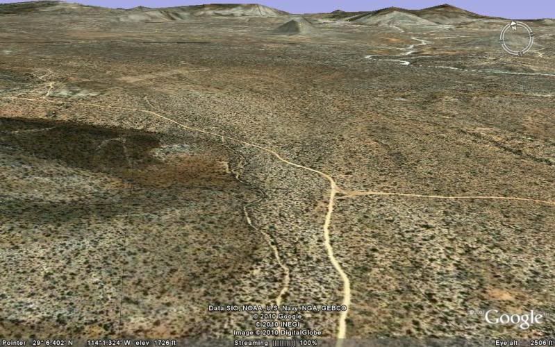
Jcn. (on Yubay road), turn right/ east to Yubay: 29°09.16'/ 114°01.36' (road ahead goes several miles north)
Yubay parking/ trail head (north, uphill, out of arroyo): 29°10.28'/ 113°59.62'
El Camino Real to south: 29°10.58'/ 113°59.21'
El Camino Real, above arroyo: 29°10.54'/ 113°59.19'
TINAJA DE YUBAY historic water hole: 29°10.68'/ 113°59.22'

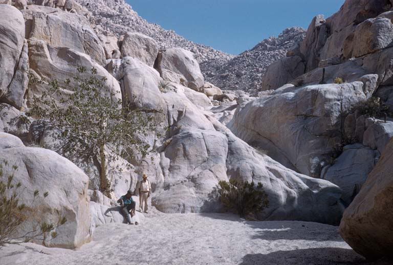
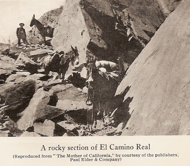
On the trail to the historic water hole of Yubay, which is in the canyon ahead. It was very hot and dry, the (less than a) mile hike to Yubay was
undertaken by most of our group.
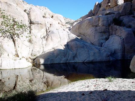
Tinaja de Yubay 7-2-01 :

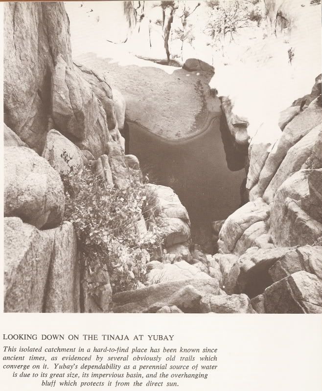
Possibly the lowest level this water hole has been in some time. GPS: N29°10.69' W113°59.26' (WGS 84) elev. 2,059'. A fig tree grows from the cliff
just to my right.

At Yubay, we take a rest as El Camote videos us. But wait....where's Debra???
Another victim of the trail to Yubay! :
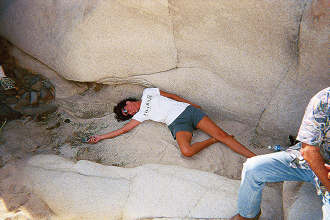
Debra's cell phone is useless in this remote desert. Perhaps the well placed Viva Baja sticker will bring assistance! Very funny Debra!

Happy to get out of Yubay alive, David K kisses a boojum!
CERRO LA PALMITA:

The cone shaped hill, as viewed on the return (southboud) trip from Yubay. The desert garden here is incredible!
GPS DIRECTIONS TO YUBAY (WGS 84)
JCN. hwy.1 & L.A. Bay hwy. N29°02.76' W114°09.17' 0.0 mi.
TURN NORTH onto dirt road N29°04.31' W114°02.41' 7.0 mi.
FORK right (left is Desengano, 0.3 mi.) N29°06.84' W114°01.65' 10.0 mi.
JCN. go right (ahead to rock palm hill, 4.2 mi.) N29°09.17' W114°01.40' 12.8 mi.
RIDGE TOP, 4WD only beyond N29°10.19' W113°59.77' 14.8 mi.
END OF ROAD in arroyo/TRAIL is straight across N29°10.29' W113°59.65' 14.9 mi.
TINAJA DE YUBAY N29°10.69' W113°59.26' 15.5 mi.
note: milages are direct, not road miles.
FROM SPACE:
L.A. Bay Hwy to Yubay...
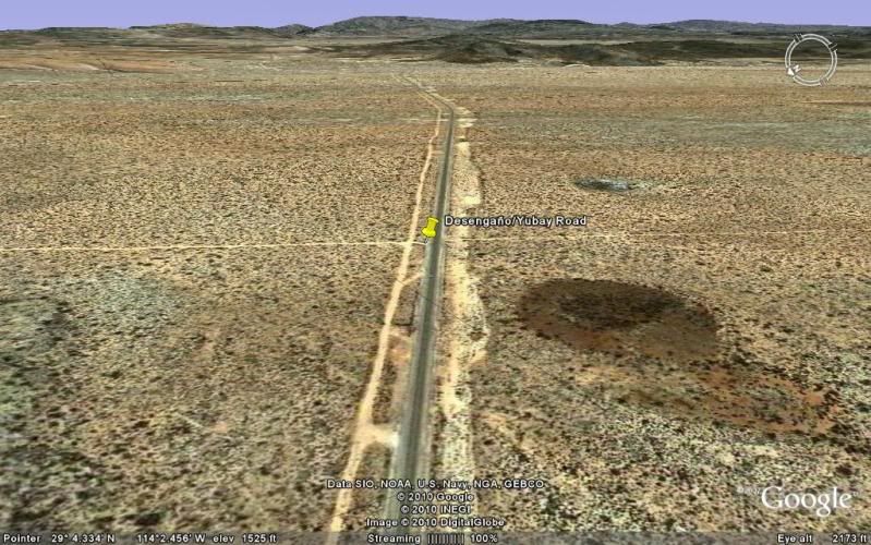
Turn north from pavement. 7 miles east of Mex. 1/ Parador Punta Prieta.
Keep left at junction with old L.A. Bay road.
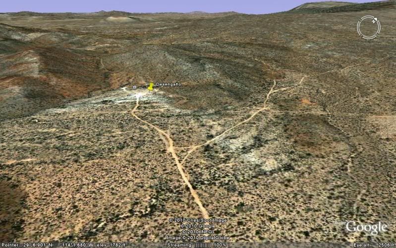
Fork right for Yubay... Desengaño mine is just ahead (worth a side trip)... old L.A. Bay road continues to Mex. 1 at Km. 270.
Turn sharp right for Yubay (towards La Palmita peak). Road ahead goes several miles passing 'Rock Palm Hill' where blue palms grow out of granite rock
on the side of hills and cliffs.
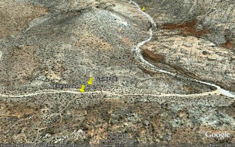
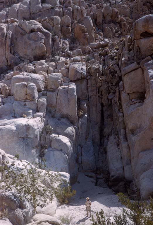
End of road in sandy arroyo... 2WD should park on hill above arroyo. Trail goes directly across arroyo to short-cut to Yubay arroyo.
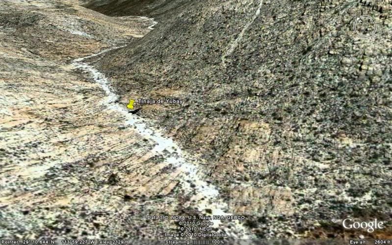
Tinaja de Yubay.
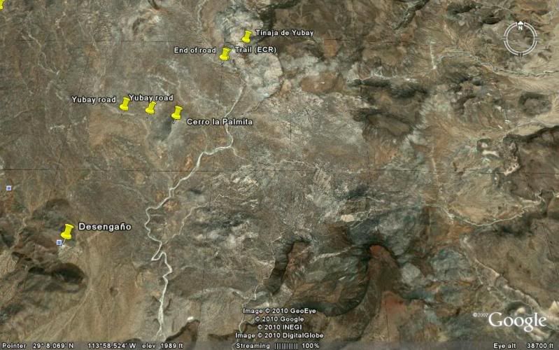
High view of area.
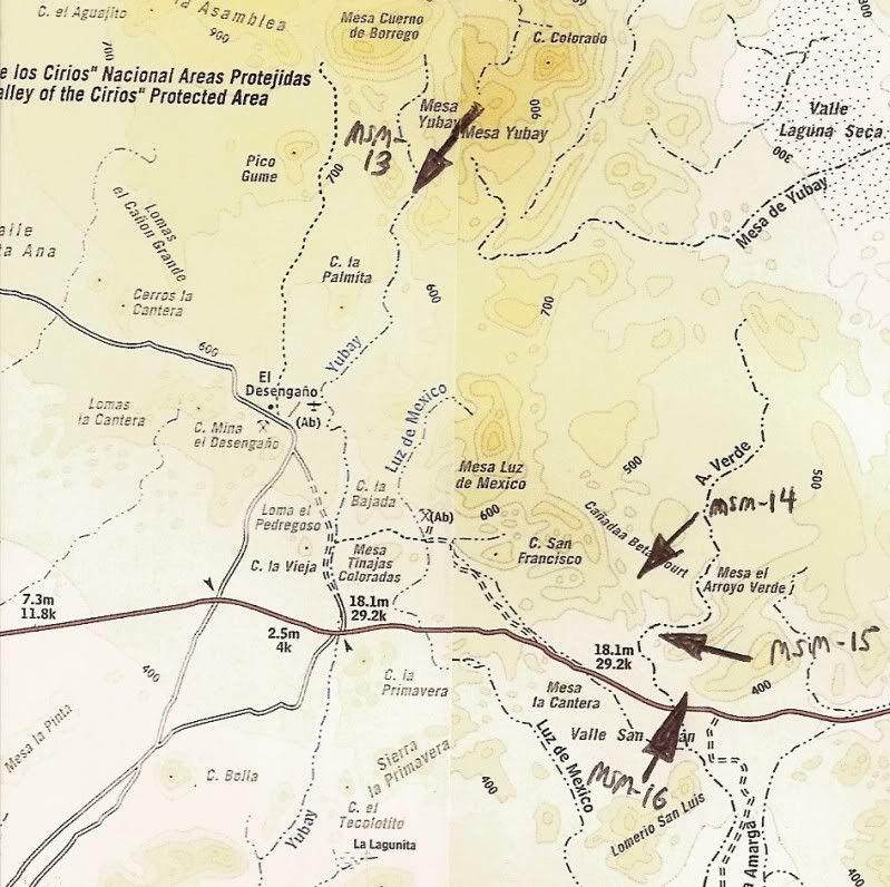
Topo map of area. Yubay is msm-13. The other arroyos point to where the Camino Real can be seen from space. See my El Camino Real from space series.
Link at http://vivabaja.com/bajamissions
Beautiful Tinaja de Yubay photos from Neal Johns at http://vivabaja.com/neal2
Tinaja was overflowing with water that trip!
Here's one from Neal's web page (see the others!):

A bit closer... note the wild fig tree growing on the cliff side(left).
This is the clue you have arrived at the true Tinaja de Yubay,
less than a mile up a canyon where those traveling the El Camino Real would stop, between the mission of San Borja and Calamajue.
[Edited on 10-10-2012 by David K]
|
|
|
David K
Honored Nomad
Posts: 64493
Registered: 8-30-2002
Location: San Diego County
Member Is Offline
Mood: Have Baja Fever
|
|
May 4, 1961 photos from Howard Gulick
The tinaja water was below the sand...
Note the fig tree growing out of the rock... In wet weather there are other tinajas before you reach the true Yubay. The fig tree is the sign you are
at the true Yubay.
|
|
|
David K
Honored Nomad
Posts: 64493
Registered: 8-30-2002
Location: San Diego County
Member Is Offline
Mood: Have Baja Fever
|
|
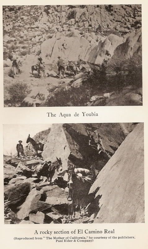
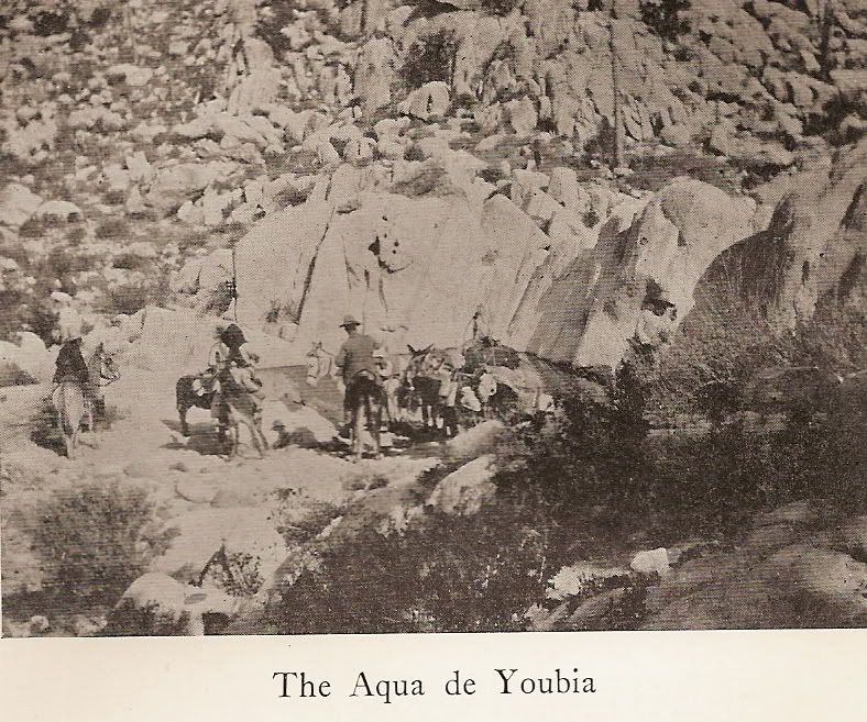
1974 Harry Crosby Book
In 'The King's Highway in Baja California', Harry Crosby includes this photo of Yubay taken from the rocks above the water hole. The fig tree is on
the right, washed out by sunlight.
|
|
|
David K
Honored Nomad
Posts: 64493
Registered: 8-30-2002
Location: San Diego County
Member Is Offline
Mood: Have Baja Fever
|
|
Jack Swords Photos
A few years ago, Nomad Jack Swords took these two photos near the tinaja...

Rock art at Tinaja de Yubay

This puma foot print was seen at Tinaja de Yubay. The cat was following Jack, as its tracks were on top of Jack's!
More of Jack's Baja photos at http://vivabaja.com/swords
|
|
|
David K
Honored Nomad
Posts: 64493
Registered: 8-30-2002
Location: San Diego County
Member Is Offline
Mood: Have Baja Fever
|
|
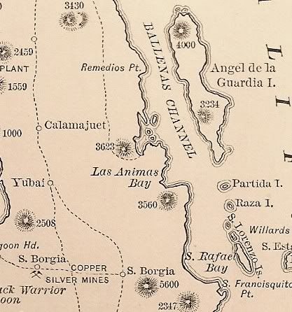
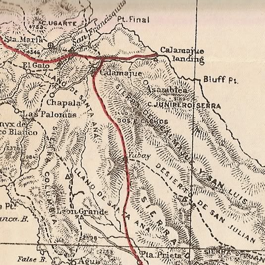
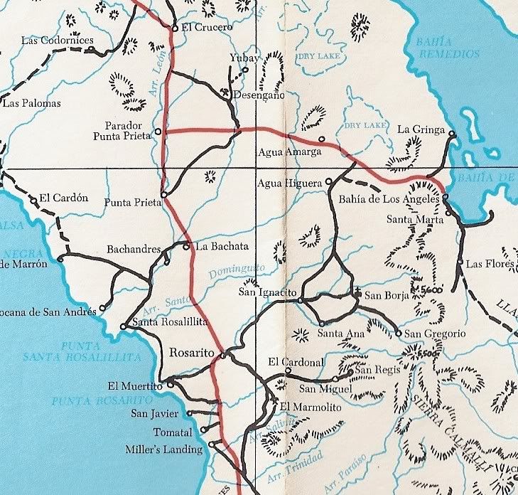
YUBAY ON MAPS
Between Calamajue and San Borja...
1888 Map:
1919 Map (1905 research):
1930 Map:
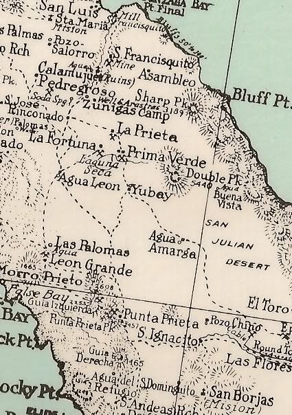
1941 Map: ('Y' blotched out)
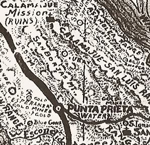
1962 Map: (first 'accurate' map)
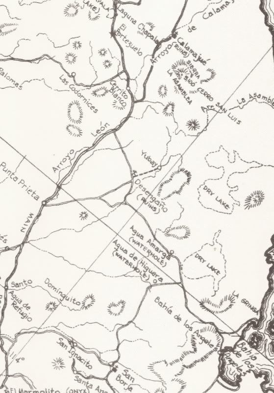
1975 Map:
[Edited on 2-5-2010 by David K]
|
|
|
wessongroup
Platinum Nomad
Posts: 21152
Registered: 8-9-2009
Location: Mission Viejo
Member Is Offline
Mood: Suicide Hot line ... please hold
|
|
Thanks that is really pretty neat.. something like that (water) out in the middle of that area is just plain amazing.. can't image folks making their
way around out there 2,3,4 hundred years ago.. thanks for all the work.. enjoyed it.. 
|
|
|
David K
Honored Nomad
Posts: 64493
Registered: 8-30-2002
Location: San Diego County
Member Is Offline
Mood: Have Baja Fever
|
|
Tinajas are life savers for sure... Places where water is protected from sunlight and the rock soil prevents it from draining away... Like a big tank.
As shown in the 1961 photos, sometimes the water is under the sand.
I think I can find some more old photos of Yubay, maybe from 1905... check back later!
|
|
|
David K
Honored Nomad
Posts: 64493
Registered: 8-30-2002
Location: San Diego County
Member Is Offline
Mood: Have Baja Fever
|
|
1905 North Expedition
From Camp and Camino in Lower California...
|
|
|
David K
Honored Nomad
Posts: 64493
Registered: 8-30-2002
Location: San Diego County
Member Is Offline
Mood: Have Baja Fever
|
|
Anyone been to Tinaja de Yubay in the past year?
|
|
|
Mexitron
Ultra Nomad
Posts: 3397
Registered: 9-21-2003
Location: Fort Worth, Texas
Member Is Offline
Mood: Happy!
|
|
No, but its an area I want to explore! Be nice to see the Tinaja but that whole area is beautiful.
|
|
|
David K
Honored Nomad
Posts: 64493
Registered: 8-30-2002
Location: San Diego County
Member Is Offline
Mood: Have Baja Fever
|
|
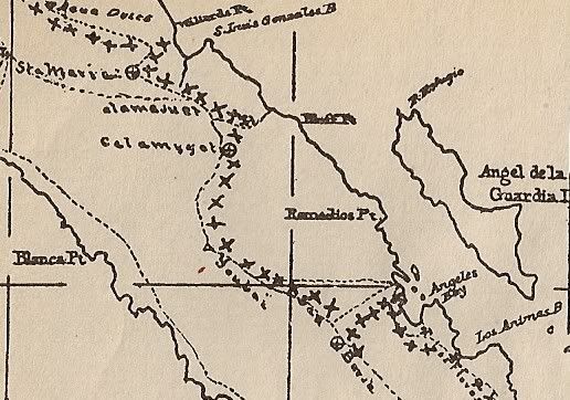
1907 Map
Here is the map in Arthur North's book zoomed in on Yubay and the surrounding region. North spelled Yubay as Youbai. North traveled the El Camino Real
much of his trip and the x's on the map are his routes.
From north to south: Agua Dulce, Santa Maria, Calamajue, Yubay, San Borja, Bahia de los Angeles, Las Flores. South of Las Flores North rejoined the
Camino Real east branch, known as the 'Golfo Camino Real' at Tinaja de Santa Maria and followed it to Santa Gertrudis.
|
|
|
David K
Honored Nomad
Posts: 64493
Registered: 8-30-2002
Location: San Diego County
Member Is Offline
Mood: Have Baja Fever
|
|
Any new photos of Yubay this year?
In Feb. 2003, Neal and Marian Johns found a very full tinaja at Yubay!:
|
|
|
David K
Honored Nomad
Posts: 64493
Registered: 8-30-2002
Location: San Diego County
Member Is Offline
Mood: Have Baja Fever
|
|
Just a bump looking for more Tinaja de Yubay photos... 
|
|
|
Ken Cooke
Elite Nomad
Posts: 8921
Registered: 2-9-2004
Location: Riverside, CA
Member Is Offline
Mood: Black Trans Lives Matter
|
|
| Quote: | Originally posted by David K
Just a bump looking for more Tinaja de Yubay photos...
|
Neal sent me some .kmz files of this region earlier this week. I need to give the guy a call.
|
|
|
David K
Honored Nomad
Posts: 64493
Registered: 8-30-2002
Location: San Diego County
Member Is Offline
Mood: Have Baja Fever
|
|
Yubay is a very important historic site and it is very easy to reach with a half mile hike.
|
|
|
Tacodawgtim
Junior Nomad
Posts: 90
Registered: 9-15-2012
Location: San Felipe. Full time
Member Is Offline
Mood: No Bad Days
|
|
I am heading back down to San Felipe the middle of November for a couple weeks. I just bookmarked your post. It should make a nice trip. I love
calamu wash. I'll let you know but sounds like a nice trip since its paved almost all the way to gonzaga. Your directions seem spot on as we made it
to agua caliente last trip down. Just have to dodge the baja 1000 racers doing their pre run. Thanks for another great trip plan.
|
|
|
David K
Honored Nomad
Posts: 64493
Registered: 8-30-2002
Location: San Diego County
Member Is Offline
Mood: Have Baja Fever
|
|
| Quote: | Originally posted by Tacodawgtim
I am heading back down to San Felipe the middle of November for a couple weeks. I just bookmarked your post. It should make a nice trip. I love
calamu wash. I'll let you know but sounds like a nice trip since its paved almost all the way to gonzaga. Your directions seem spot on as we made it
to agua caliente last trip down. Just have to dodge the baja 1000 racers doing their pre run. Thanks for another great trip plan.
|
De nada... I would like to see your photos of Agua Caliente Canyon, hot springs, read what you saw there... etc. I did see the photo of the big barrel
cactus you posted, but was there any more? Thank you!
|
|
|
bacquito
Super Nomad
Posts: 1615
Registered: 3-6-2007
Member Is Offline
Mood: jubilado
|
|
Really a great and interesting report. Thanks
bacquito
|
|
|
marv sherrill
Nomad
Posts: 456
Registered: 11-18-2003
Member Is Offline
|
|
David I was there with some friends last year. The water was pretty low, the hike in was great with lots of little water holes along the way. The
road in was pretty bad - make sure your shocks are in good shape and your vehicle is on the narrow side, and keep your arms inside the windows!
I ended up with a lap full of ocotillo and many other plant species throughout the trip! I'll see if I can locate the pictures - we used you GPS
makings and only got lost because I thought your numbered GPS entrys were mile markers....I'm not a techno wizard.
|
|
|
Tacodawgtim
Junior Nomad
Posts: 90
Registered: 9-15-2012
Location: San Felipe. Full time
Member Is Offline
Mood: No Bad Days
|
|
David, when I went to Aqua Caliente last month it was pretty warm. Went with some friends. The road was washed out, could have made it in a jeep but
we were in buggies and with wives. From what GPS numbers I had we were about 3-4 miles from the actual spring, just past a rancho. It was 100 + and no
one felt like walking to hot springs. There is quite a bit of legitimate farming going on there. When I go back in November ill try to get back up
there and take pictures, ill hike in. Opposite the large barrel cactus was some drawings on some rocks. We got in almost a mile past that.
|
|
|
| Pages:
1
2 |


