bajaamy
Newbie
Posts: 23
Registered: 10-29-2008
Member Is Offline
|
|
anyone been to the cave paintings SE of San Ignacio?
Hi, All--
I note in Harry Crosby's cave painting book that there's a crop of them SE of San Ignacio in the mountains (or NWish of San Jose de Magdalena).
Anyone ever explored that area?
|
|
|
David K
Honored Nomad

Posts: 64543
Registered: 8-30-2002
Location: San Diego County
Member Is Offline
Mood: Have Baja Fever
|
|
Hi Amy... I am looking at the map on page 118 (of Harry's newer cave book) of this region... which site are you interested in?
I see San Borjitas Norte, San Antonio, La Candelaria... or any of those?
Nomad 'Cristobal' has spent time in that region, perhaps search his posts?
|
|
|
baja Steve
Nomad
Posts: 469
Registered: 8-31-2003
Location: Bend, or
Member Is Offline
|
|
that is in the Santa Martha are and been there a lot. Work with the boarding school and ranchers in that area
|
|
|
David K
Honored Nomad
Posts: 64543
Registered: 8-30-2002
Location: San Diego County
Member Is Offline
Mood: Have Baja Fever
|
|
Steve, Santa Marta (Martha) is northeast of San Ignacio...
|
|
|
baja Steve
Nomad
Posts: 469
Registered: 8-31-2003
Location: Bend, or
Member Is Offline
|
|
you are right.
|
|
|
baja Steve
Nomad
Posts: 469
Registered: 8-31-2003
Location: Bend, or
Member Is Offline
|
|
Another area I work in with ranchers is SE of San Ignacio I go east form San Ignacio on HY 1 I think they call Arroyo Grande about 1/2 way to Bonfil
head south to just past las Cuevtias and then head east great people.
|
|
|
David K
Honored Nomad
Posts: 64543
Registered: 8-30-2002
Location: San Diego County
Member Is Offline
Mood: Have Baja Fever
|
|
One old post from Cristobal on the area: http://forums.bajanomad.com/viewthread.php?tid=8463
|
|
|
shari
Select Nomad
Posts: 13034
Registered: 3-10-2006
Location: bahia asuncion, baja sur
Member Is Offline
Mood: there is no reality except the one contained within us "Herman Hesse"
|
|
I really loved the Sta.Marta cave paintings and you can visit them in one day. We camped at the ranch one night and set out in the morning with our
guide...it's about a 2 hour hike up to the caves.
This Santa Marta is southeast of San Ignacio...you enter from Bonfil.
|
|
|
David K
Honored Nomad
Posts: 64543
Registered: 8-30-2002
Location: San Diego County
Member Is Offline
Mood: Have Baja Fever
|
|
Where?
| Quote: | Originally posted by shari...
This Santa Marta is southeast of San Ignacio...you enter from Bonfil. |
Not to question Shari as much, but to provide the most accurate Baja information... unless there is another Santa Marta, reached from Bonfil?
The Santa Marta where one can hire guides to see cave art is north of San Ignacio... and even a hair west of north... reached after driving east from
San Ignacio, then north and then west on a dirt road.
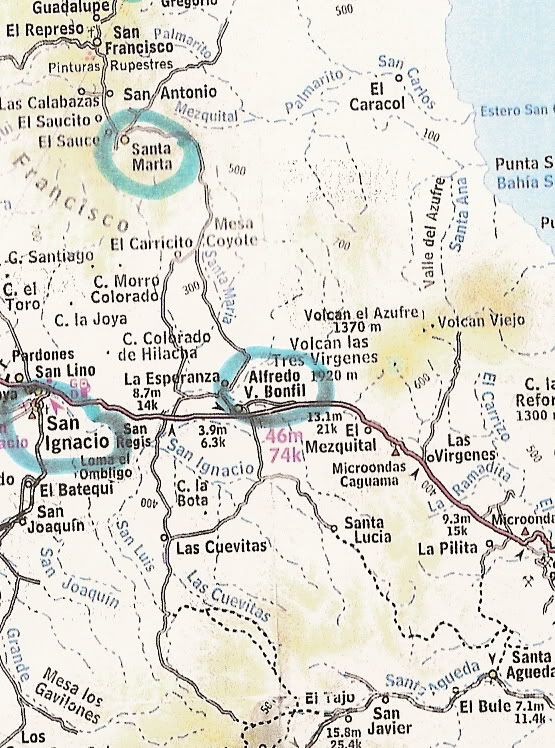
On the AAA map, with mileages...
[Edited on 2-24-2010 by David K]
|
|
|
shari
Select Nomad
Posts: 13034
Registered: 3-10-2006
Location: bahia asuncion, baja sur
Member Is Offline
Mood: there is no reality except the one contained within us "Herman Hesse"
|
|
right David...as the crow flies it is a tad northeast...but the entrance to get to sta.marta, I always think of the highway as north-south but
technically, it is east-west in many parts...I just think of it as south of san ignacio in my pea brain...driving south from san ignacio to
sta.rosalia as opposed to driving north from san ignacio to vizcaino...oh never mind.
|
|
|
David K
Honored Nomad
Posts: 64543
Registered: 8-30-2002
Location: San Diego County
Member Is Offline
Mood: Have Baja Fever
|
|
Okay, thanks for that Shari... I thought that may have been your thinking... But, there may be another Santa Marta out there... just like there is
more than one Arce in that sierra!!!
Anyway, Amy is asking about the other side of Hwy. 1, as shown on Harry Crosby's maps and cave painting books...
|
|
|
David K
Honored Nomad
Posts: 64543
Registered: 8-30-2002
Location: San Diego County
Member Is Offline
Mood: Have Baja Fever
|
|
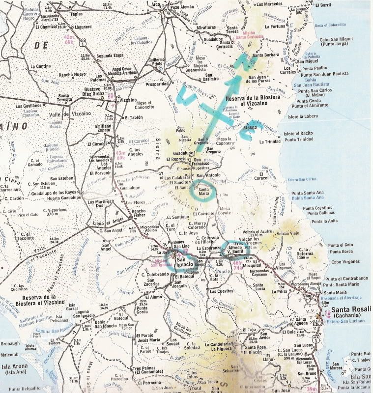
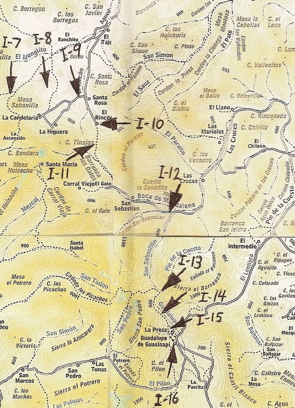
Here are the cave sites shown on Harry's map... southeast of San Ignacio:
[Edited on 2-24-2010 by David K]
|
|
|
Fred-o
Junior Nomad
Posts: 84
Registered: 7-6-2008
Location: Punta Banda
Member Is Offline
|
|
"Badges" for cave paintings?
Yes; if you go to the site where you turn off about 20 miles N. out of San Ignatio (going towards San Vicente) and then another 20 or so into the
paintings site area. Can't remember the mileage.
Anyway: Be sure to get your permits (about $10.00 USD per person) at a little rock walled chamber right next to the Church in the Plaza at San
Ignatio. (Just to the left of the church when facing it) It's Like going into a innersanctum, but I think it's a museum. They told us, "no permit, no
guide", and they keep the area locked. You cannot get into it without a guide who has the key. You actually have to go past the cave painting site to
get to the village where you will give them your permit, and a guide will lead you over to the site and stay with you during the tour..
It might have changed, but "red tape" never seems to. And, at that time, you could not purchase the permits at the cave painting site. The guide will
also expect a tip, that's their only income that I could see.
Bueno Suerte amigos...
|
|
|
David K
Honored Nomad
Posts: 64543
Registered: 8-30-2002
Location: San Diego County
Member Is Offline
Mood: Have Baja Fever
|
|
That is the road to San Francisco de la Sierra... and the cave along the road before the village is Cueva del Ratón.

|
|
|
cristobal
Nomad
Posts: 194
Registered: 12-16-2003
Location: california
Member Is Offline
|
|
Hi gang ... I've been away for a while ...
I haven't been to any of the cave paintings southeast Of San Ignacio but I did see some drawings on private property west of Las Higueras which is
just east of La Candelaria.
I did some hiking above Las Higueras and since it is so rough I left my camera at the rancho. ... mistake ...
|
|
|
David K
Honored Nomad
Posts: 64543
Registered: 8-30-2002
Location: San Diego County
Member Is Offline
Mood: Have Baja Fever
|
|
Hola Cristobal!!
Hope you can get back up to that beautiful country again!
By-the-way... I have better details on the Camino Real through there than last time we talked about LA CANDELARIA. The mission trail did come down the
mountain at RANCHO EL RINCON and the headed north passing just west of RANCHO SANTA ROSA, then curved westward... staying to the north of LA
CANDELARIA as it heads towards SAN IGNACIO.
Previous to my Google Earth tracing of it, we believed it went through LA HIGUERA and LA CANDERARIA. That trail may have been a newer route, or a
bipassed older one?
Hasta Pronto!
|
|
|
David K
Honored Nomad
Posts: 64543
Registered: 8-30-2002
Location: San Diego County
Member Is Offline
Mood: Have Baja Fever
|
|
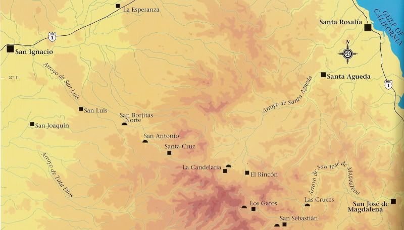
Here is that area (Image #9)... looking southbound towards El Rincon, as it crosses the auto road to La Candelaria....
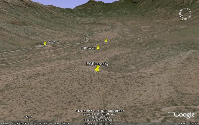
Note the arrows pointing the Camino Real located with Google Earth, and I-9 being the image above:
|
|
|
cristobal
Nomad
Posts: 194
Registered: 12-16-2003
Location: california
Member Is Offline
|
|
Hello David ...
What great maps you have ... awesome ...
the trail that comes down the hill to Rincon is still there and it is just that ... a trail. From RINCON north they have graded the trail into a road
to west of Santa Rosa where it continues to LLANO and then up to LA CANDELARIA. The trail from SANTA ROSA to LAS HIGUERAS was undrivable for many
years but Manual Villavicencio of LH had the trail graded into a road and it saves him 40 minutes driving time to SR. That is what you call progress
...
  : :  
|
|
|
David K
Honored Nomad
Posts: 64543
Registered: 8-30-2002
Location: San Diego County
Member Is Offline
Mood: Have Baja Fever
|
|
Great to hear from a Nomad who has been there! That trail coming down the mountain at El Rincon was the Jesuit's mission road!
|
|
|


