| Pages:
1
..
5
6
7
8
9
..
11 |
BajaNews
Super Moderator

Posts: 1439
Registered: 12-11-2005
Member Is Offline
|
|
Near the epicenter, jittery residents tell of quake's power
http://www.latimes.com/news/la-me-guadalupe5-2010apr05,0,318...
By Alan Zarembo and Ruben Vives
April 4, 2010
David Serrano was at home in Guadalupe Victoria, Mexico, watching a Star Trek movie with his 3-year-old daughter when the room began to shake.
At first, he thought it was one of the mini-quakes that had occasionally rattled his town for the last few months. Temblors as big as 4.4, with their
epicenters as close as 11 miles away, had been going off all morning, according to the U.S. Geological Survey.
But Serrano quickly realized this one was different. The television went dark. And the shaking intensified.
He hollered for his girlfriend, grabbed their daughter and ran into the yard. They stumbled as the earth moved beneath them. It was a 7.2 -- more
powerful than the 1994 Northridge quake. It shook all of northwest Mexico and was felt as far away as Bakersfield and Las Vegas.
Serrano and his family were about 16 miles from the epicenter.
He looked down the street and saw an old, abandoned building collapse.
Guadalupe Victoria, an agricultural town of 16,000 people, wasn't known for much before the earthquake. In the first several hours after the quake,
news reports focused primarily on damage in downtown Mexicali, on the U.S. border about 30 miles away. But on the map, no town is closer to the center
of Sunday's earthquake.
Given its location, Guadalupe Victoria seems to have fared surprisingly well -- though Baja California state justice officials reached by phone said
the full extent of damage has yet to be determined. Around town, windows broke and streets, bridges and irrigation canals suffered damage, they said.
"It's been difficult trying to get from one place to another," said Jose Isla Barra, who works at the state justice department's office in Guadalupe
Victoria.
Serrano, a carpenter who works in Calexico on the U.S. side of the border, said by telephone that all the houses on his street remained upright. He
noticed that the wall of the tiny baseball stadium came down. And on one street, he could see into an apartment whose wall had crumbled.
Without electricity or water, most stores remained closed Sunday night. People lined up at a hot dog stand that his girlfriend's parents run. They
cook with gas and quickly sold out, even though hot dogs were not what many of their customers had planned for Easter supper.
Six hours after the quake, there was still no water or power, although phone lines remained intact.
Serrano described the streets as more crowded than usual, as fear kept people outside their homes.
The aftershocks kept coming -- dozens of them. "There goes another one," he said.
He said that he and his family, like many residents, were planning to sleep in their cars Sunday night in case a bigger quake was on the way.
|
|
|
BajaNews
Super Moderator
Posts: 1439
Registered: 12-11-2005
Member Is Offline
|
|
Men talk outside a collapsed house as cracks are seen on the street in Mexicali, Mexico, early Monday, April 5, 2010 after a powerful earthquake
struck. According to the USGS,the earthquake was centered 26 km (16 miles) south west from Guadalupe Victoria, Baja California, Mexico.
(AP Photo/Guillermo Arias)

|
|
|
BajaNews
Super Moderator
Posts: 1439
Registered: 12-11-2005
Member Is Offline
|
|
Men walk near their destroyed house early Monday, April 5, 2010 after a powerful earthquake hit Mexicali, Mexico, early Monday, April 5, 2010.
(AP Photo/Guillermo Arias)

|
|
|
BajaNews
Super Moderator
Posts: 1439
Registered: 12-11-2005
Member Is Offline
|
|
A car passes over a crack on the road at the 30th kilometer of the Mexicali-Tijuana highway made by a 7.2 earthquake in Mexicali, Mexico, Sunday,
April 4, 2010.
(AP Photo/Guillermo Arias)

|
|
|
Sur2baja
Junior Nomad
Posts: 54
Registered: 10-8-2006
Location: Fallbrook, CA/Nuevo Mazatlan
Member Is Offline
|
|
As of 0630, Calexico East crossing is open to commercial and passenger vehicles. Pedestrian crossing still closed.
|
|
|
BajaNews
Super Moderator
Posts: 1439
Registered: 12-11-2005
Member Is Offline
|
|
http://www.sanfelipe.com.mx/news/index.html
Apr 04; 11:30 p.m.: A parking garage at the city hall in Mexicali is reported to have collapsed but no injuries have been reported. There is also
structural damage to the Mexicali water system. The Crown Plaza Hotel in Mexicali has minor damage. Electricity is reported to still be off and the
result is that most of the government information servers are unavailable. Here are a few key telephone numbers in Mexicali for people who will be
travelling through the city on Monday:
Mexicali Tourist office (011-52)-(686) 566-1277.
Conventions and Tourism bureau (686)-551-9800 (in Mexicali) or (686)-577-2300 (in San Felipe).
San Felipe police department (686) 577-1134
San Felipe Fire Department (has road conditions) (686) 577-1882
San Felipe Mayor's Office: (686) 577-1021
Apr 04; 9 p.m.: The Mexicali Road is closed at La Ventana and traffic north is being turned back to San Felipe. No word on whether the Ensenada Road
is also closed but that would be the only other possible route for people returning to California or the border region. (11:30 p.m. update: I hear
that construction equipment from the road upgrade project around the Ensenada Road junction is already being used to clear the path at La Ventana.)
[Edited on 4-5-2010 by BajaNews]
|
|
|
jodiego
Nomad
Posts: 317
Registered: 2-16-2007
Location: San Diego
Member Is Offline
Mood: ever hopeful
|
|
Just felt an aftershock at 6:33 here in San Diego. The initial tremor of 7.2 is HUGE! The Loma Prieta quake in 1989 was 7.1. The Northridge quake
in 1994 was 6.9. A couple of miles west and San Diego and Tijuana could have really gotten hammered.
[Edited on 4-5-2010 by jodiego]
|
|
|
cj5orion
Nomad
Posts: 336
Registered: 2-6-2010
Location: Pacific Beach/Gonzaga Bay
Member Is Offline
Mood: time for a cervaza !!!
|
|
any road reports ?????
San Fellippi to Mexicalli ???????
Home Remodels/Builds..Recession!
Gone BAJA BUILDIN/FISHIN !
|
|
|
Sur2baja
Junior Nomad
Posts: 54
Registered: 10-8-2006
Location: Fallbrook, CA/Nuevo Mazatlan
Member Is Offline
|
|
We're all waiting on that one aren't we?
|
|
|
BajaNews
Super Moderator
Posts: 1439
Registered: 12-11-2005
Member Is Offline
|
|
Many aftershocks since 7.2 yesterday, including 5.1 at 6:33am this morning:
http://quake.usgs.gov/recenteqs/Maps/116-33_eqs.htm
MAG DATE LOCAL-TIME LAT LON DEPTH LOCATION
2.9 2010/04/05 06:54:53 32.599N 115.795W 0.2 24 km (15 mi) SSW of Seeley, CA
2.8 2010/04/05 06:53:55 32.629N 115.790W 3.2 20 km (13 mi) SSW of Seeley, CA
3.0 2010/04/05 06:46:13 32.414N 115.621W 12.1 30 km (19 mi) SSW of Mexicali, Baja California, Mexico
2.8 2010/04/05 06:45:52 32.640N 115.808W 2.4 20 km (13 mi) SSW of Seeley, CA
2.4 2010/04/05 06:44:14 32.633N 115.815W 4.4 21 km (13 mi) SE of Ocotillo, CA
5.1 2010/04/05 06:33:05 32.640N 115.801W 0.0 20 km (12 mi) SSW of Seeley, CA
3.5 2010/04/05 06:27:28 32.292N 115.287W 32.5 17 km (10 mi) W of Guadalupe Victoria, Baja California, Mexico
2.5 2010/04/05 06:26:38 32.631N 115.824W 11.9 20 km (13 mi) SE of Ocotillo, CA
3.4 2010/04/05 06:24:55 32.590N 115.777W 2.5 24 km (15 mi) SSW of Seeley, CA
2.4 2010/04/05 06:22:03 32.667N 115.932W 6.3 10 km ( 6 mi) SE of Ocotillo, CA
1.9 2010/04/05 06:17:51 32.623N 115.745W 4.9 20 km (12 mi) SSW of Seeley, CA
2.6 2010/04/05 06:16:55 32.556N 115.742W 10.9 27 km (17 mi) WSW of Calexico, CA
1.7 2010/04/05 06:15:55 33.258N 116.141W 6.8 13 km ( 8 mi) N of Ocotillo Wells, CA
2.3 2010/04/05 06:10:37 32.698N 115.828W 3.2 16 km (10 mi) ESE of Ocotillo, CA
3.6 2010/04/05 06:07:27 32.591N 115.751W 1.4 23 km (14 mi) SSW of Seeley, CA
3.0 2010/04/05 06:04:21 32.776N 115.257W 6.2 12 km ( 8 mi) ESE of Holtville, CA
2.4 2010/04/05 06:03:19 32.545N 115.795W 10.9 29 km (18 mi) SE of Ocotillo, CA
3.1 2010/04/05 05:59:49 32.592N 115.761W 0.0 23 km (14 mi) SSW of Seeley, CA
1.4 2010/04/05 05:56:07 33.824N 116.326W 4.2 6 km ( 4 mi) E of Thousand Palms, CA
2.5 2010/04/05 05:55:56 32.601N 115.794W 1.6 23 km (15 mi) SSW of Seeley, CA
2.0 2010/04/05 05:54:40 32.593N 115.749W 2.9 23 km (14 mi) SSW of Seeley, CA
2.5 2010/04/05 05:52:57 33.260N 116.139W 8.0 13 km ( 8 mi) N of Ocotillo Wells, CA
2.7 2010/04/05 05:52:26 33.020N 115.906W 18.7 25 km (16 mi) ESE of Ocotillo Wells, CA
4.0 2010/04/05 05:49:35 32.567N 115.740W 4.5 25 km (16 mi) S of Seeley, CA
3.2 2010/04/05 05:47:36 32.654N 115.804W 1.1 19 km (12 mi) SW of Seeley, CA
2.6 2010/04/05 05:46:53 32.710N 115.753W 6.0 11 km ( 7 mi) SSW of Seeley, CA
2.5 2010/04/05 05:45:47 32.542N 115.711W 12.8 25 km (16 mi) SW of Calexico, CA
2.2 2010/04/05 05:41:19 32.672N 115.796W 5.6 17 km (10 mi) SW of Seeley, CA
2.0 2010/04/05 05:40:21 32.874N 115.989W 23.3 15 km ( 9 mi) N of Ocotillo, CA
2.8 2010/04/05 05:35:37 32.514N 115.671W 5.7 24 km (15 mi) SW of Mexicali, Baja California, Mexico
3.0 2010/04/05 05:31:59 32.166N 115.274W 7.0 21 km (13 mi) SW of Guadalupe Victoria, Baja California, Mexico
2.3 2010/04/05 05:31:04 32.647N 115.787W 0.9 19 km (12 mi) SSW of Seeley, CA
2.0 2010/04/05 05:29:40 32.799N 116.195W 7.9 20 km (12 mi) WNW of Ocotillo, CA
2.7 2010/04/05 05:27:39 32.654N 115.840W 5.5 18 km (11 mi) ESE of Ocotillo, CA
2.7 2010/04/05 05:27:02 32.669N 116.237W 0.8 7 km ( 4 mi) NW of Jacumba Hot Springs, CA
2.5 2010/04/05 05:25:26 32.849N 116.040W 8.1 13 km ( 8 mi) NNW of Ocotillo, CA
2.5 2010/04/05 05:24:49 32.684N 115.857W 6.6 14 km ( 9 mi) ESE of Ocotillo, CA
2.6 2010/04/05 05:22:23 32.636N 115.739W 4.2 18 km (11 mi) SSW of Seeley, CA
3.3 2010/04/05 05:17:02 32.285N 115.322W 25.9 20 km (12 mi) W of Guadalupe Victoria, Baja California, Mexico
3.3 2010/04/05 05:10:40 32.290N 115.333W 20.2 21 km (13 mi) W of Guadalupe Victoria, Baja California, Mexico
2.9 2010/04/05 05:10:05 32.515N 115.628W 8.1 21 km (13 mi) SW of Mexicali, Baja California, Mexico
2.0 2010/04/05 05:08:16 33.252N 116.284W 10.3 8 km ( 5 mi) E of Borrego Springs, CA
3.2 2010/04/05 05:06:29 32.657N 115.807W 5.8 19 km (12 mi) SW of Seeley, CA
2.8 2010/04/05 05:05:50 32.605N 115.750W 1.2 22 km (13 mi) SSW of Seeley, CA
2.4 2010/04/05 05:04:13 32.554N 115.703W 14.9 24 km (15 mi) SW of Calexico, CA
2.4 2010/04/05 05:03:07 32.895N 115.897W 1.7 20 km (12 mi) NNE of Ocotillo, CA
2.6 2010/04/05 04:57:41 32.601N 115.808W 1.2 23 km (15 mi) SE of Ocotillo, CA
2.9 2010/04/05 04:56:13 32.661N 115.816W 6.1 19 km (12 mi) SW of Seeley, CA
2.9 2010/04/05 04:53:53 32.589N 115.725W 11.7 23 km (14 mi) S of Seeley, CA
2.5 2010/04/05 04:49:55 32.660N 115.760W 2.2 16 km (10 mi) SSW of Seeley, CA
3.4 2010/04/05 04:48:10 32.603N 115.729W 10.3 21 km (13 mi) S of Seeley, CA
2.6 2010/04/05 04:46:50 32.608N 115.719W 2.8 21 km (13 mi) S of Seeley, CA
2.1 2010/04/05 04:45:45 32.590N 115.730W 6.7 23 km (14 mi) S of Seeley, CA
2.3 2010/04/05 04:44:27 33.172N 116.407W 14.1 9 km ( 6 mi) SSW of Borrego Springs, CA
3.0 2010/04/05 04:44:02 32.516N 115.671W 3.2 24 km (15 mi) SW of Calexico, CA
2.1 2010/04/05 04:42:45 32.707N 115.987W 6.2 4 km ( 2 mi) SSE of Ocotillo, CA
3.1 2010/04/05 04:40:32 32.606N 115.782W 1.2 22 km (14 mi) SSW of Seeley, CA
2.2 2010/04/05 04:39:45 32.673N 115.819W 5.7 18 km (11 mi) SW of Seeley, CA
2.3 2010/04/05 04:37:52 32.662N 115.812W 3.3 18 km (11 mi) SW of Seeley, CA
2.3 2010/04/05 04:37:02 32.654N 115.812W 16.7 19 km (12 mi) SW of Seeley, CA
2.7 2010/04/05 04:33:45 32.633N 115.783W 0.1 20 km (12 mi) SSW of Seeley, CA
2.8 2010/04/05 04:31:21 32.615N 115.740W 2.2 20 km (13 mi) SSW of Seeley, CA
2.6 2010/04/05 04:29:37 32.592N 115.681W 27.4 20 km (12 mi) WSW of Calexico, CA
3.4 2010/04/05 04:27:07 32.599N 115.761W 1.8 23 km (14 mi) SSW of Seeley, CA
3.4 2010/04/05 04:25:58 32.624N 115.731W 4.0 19 km (12 mi) SSW of Seeley, CA
2.8 2010/04/05 04:25:09 32.643N 115.821W 10.1 20 km (12 mi) ESE of Ocotillo, CA
2.8 2010/04/05 04:23:48 32.947N 116.337W 0.8 22 km (14 mi) NE of Pine Valley, CA
3.2 2010/04/05 04:23:18 32.649N 115.757W 2.3 17 km (11 mi) SSW of Seeley, CA
3.5 2010/04/05 04:20:46 32.768N 116.095W 0.0 10 km ( 6 mi) WNW of Ocotillo, CA
3.7 2010/04/05 04:20:27 32.642N 115.821W 6.4 20 km (12 mi) ESE of Ocotillo, CA
5.1 2010/04/05 04:14:14 32.662N 115.807W 13.1 18 km (11 mi) SW of Seeley, CA
3.0 2010/04/05 04:12:29 32.208N 115.332W 5.6 23 km (14 mi) WSW of Guadalupe Victoria, Baja California, Mexico
2.4 2010/04/05 04:08:57 33.082N 116.781W 15.2 9 km ( 6 mi) N of San Diego Country Estates, CA
2.5 2010/04/05 04:08:11 33.183N 116.422W 7.1 9 km ( 5 mi) SSW of Borrego Springs, CA
2.5 2010/04/05 04:04:42 32.674N 115.846W 5.1 16 km (10 mi) ESE of Ocotillo, CA
3.3 2010/04/05 04:02:54 32.177N 115.315W 0.4 23 km (14 mi) WSW of Guadalupe Victoria, Baja California, Mexico
2.9 2010/04/05 03:58:37 32.652N 115.799W 0.0 19 km (12 mi) SSW of Seeley, CA
1.6 2010/04/05 03:56:45 33.988N 116.984W 18.7 7 km ( 4 mi) N of Beaumont, CA
2.7 2010/04/05 03:54:08 32.645N 115.799W 0.0 19 km (12 mi) SSW of Seeley, CA
3.1 2010/04/05 03:49:44 32.298N 115.329W 10.0 21 km (13 mi) W of Guadalupe Victoria, Baja California, Mexico
3.1 2010/04/05 03:48:02 32.571N 115.754W 12.1 25 km (16 mi) SSW of Seeley, CA
2.6 2010/04/05 03:46:42 33.450N 116.480W 12.3 21 km (13 mi) ESE of Anza, CA
3.3 2010/04/05 03:43:23 32.660N 115.808W 0.7 18 km (11 mi) SW of Seeley, CA
3.4 2010/04/05 03:39:20 32.585N 115.738W 9.4 23 km (15 mi) S of Seeley, CA
2.6 2010/04/05 03:36:28 32.593N 116.065W 26.5 12 km ( 7 mi) ESE of Jacumba Hot Springs, CA
3.4 2010/04/05 03:33:02 32.634N 115.790W 1.9 20 km (12 mi) SSW of Seeley, CA
3.7 2010/04/05 03:30:57 32.020N 115.282W 7.0 34 km (21 mi) SSW of Guadalupe Victoria, Baja California, Mexico
2.6 2010/04/05 03:29:51 33.353N 116.318W 13.2 13 km ( 8 mi) NNE of Borrego Springs, CA
2.2 2010/04/05 03:25:43 32.682N 115.807W 1.4 16 km (10 mi) SW of Seeley, CA
3.1 2010/04/05 03:19:52 32.453N 115.811W 9.3 36 km (23 mi) SSE of Ocotillo, CA
2.4 2010/04/05 03:17:48 32.687N 115.877W 6.4 13 km ( 8 mi) ESE of Ocotillo, CA
2.6 2010/04/05 03:17:22 32.568N 115.685W 8.1 21 km (13 mi) SW of Calexico, CA
2.9 2010/04/05 03:15:40 32.508N 115.694W 10.3 26 km (16 mi) SW of Calexico, CA
2.7 2010/04/05 03:14:07 32.833N 116.254W 0.1 25 km (15 mi) NNW of Jacumba Hot Springs, CA
2.9 2010/04/05 03:13:34 32.770N 116.540W 2.5 7 km ( 4 mi) S of Pine Valley, CA
4.0 2010/04/05 03:09:24 32.206N 115.221W 10.0 14 km ( 9 mi) SW of Guadalupe Victoria, Baja California, Mexico
4.0 2010/04/05 03:05:36 32.635N 115.801W 14.1 20 km (13 mi) SSW of Seeley, CA
3.4 2010/04/05 03:01:10 32.495N 115.676W 0.4 26 km (16 mi) SW of Mexicali, Baja California, Mexico
3.5 2010/04/05 02:58:35 32.123N 115.290W 5.4 25 km (16 mi) SW of Guadalupe Victoria, Baja California, Mexico
3.0 2010/04/05 02:56:03 32.605N 115.758W 2.9 22 km (14 mi) SSW of Seeley, CA
3.0 2010/04/05 02:55:37 32.601N 115.746W 7.2 22 km (14 mi) SSW of Seeley, CA
3.9 2010/04/05 02:52:56 32.280N 115.376W 16.0 25 km (16 mi) W of Guadalupe Victoria, Baja California, Mexico
2.6 2010/04/05 02:52:10 32.630N 115.753W 2.3 19 km (12 mi) SSW of Seeley, CA
2.6 2010/04/05 02:50:26 32.617N 115.730W 7.8 20 km (12 mi) S of Seeley, CA
2.9 2010/04/05 02:40:00 32.654N 115.787W 2.6 18 km (11 mi) SSW of Seeley, CA
2.5 2010/04/05 02:29:10 32.633N 115.800W 3.9 20 km (13 mi) SSW of Seeley, CA
3.1 2010/04/05 02:26:31 32.393N 115.560W 0.7 30 km (19 mi) SSW of Mexicali, Baja California, Mexico
2.5 2010/04/05 02:23:53 32.629N 115.790W 1.6 20 km (13 mi) SSW of Seeley, CA
3.1 2010/04/05 02:22:25 32.352N 115.509W 12.8 34 km (21 mi) S of Mexicali, Baja California, Mexico
2.3 2010/04/05 02:17:06 32.632N 115.759W 1.9 19 km (12 mi) SSW of Seeley, CA
3.4 2010/04/05 02:15:55 32.331N 115.334W 12.9 22 km (13 mi) WNW of Guadalupe Victoria, Baja California, Mexico
2.6 2010/04/05 02:15:21 32.603N 115.788W 0.0 23 km (14 mi) SSW of Seeley, CA
2.7 2010/04/05 02:13:37 32.614N 115.737W 4.4 20 km (13 mi) SSW of Seeley, CA
3.3 2010/04/05 02:12:43 32.285N 115.305W 12.8 18 km (11 mi) W of Guadalupe Victoria, Baja California, Mexico
2.9 2010/04/05 02:04:48 32.458N 115.588W 10.1 24 km (15 mi) SSW of Mexicali, Baja California, Mexico
3.6 2010/04/05 02:01:26 32.317N 115.335W 0.5 21 km (13 mi) W of Guadalupe Victoria, Baja California, Mexico
2.6 2010/04/05 01:59:53 32.528N 115.700W 8.8 25 km (16 mi) SW of Calexico, CA
2.9 2010/04/05 01:57:16 32.402N 115.549W 0.6 29 km (18 mi) SSW of Mexicali, Baja California, Mexico
1.9 2010/04/05 01:56:05 32.960N 116.087W 3.3 21 km (13 mi) S of Ocotillo Wells, CA
2.4 2010/04/05 01:52:20 32.583N 115.669W 3.3 19 km (12 mi) WSW of Calexico, CA
3.3 2010/04/05 01:47:45 32.499N 115.659W 4.7 25 km (15 mi) SW of Mexicali, Baja California, Mexico
2.5 2010/04/05 01:45:11 32.542N 115.731W 3.3 27 km (17 mi) SW of Calexico, CA
3.4 2010/04/05 01:42:22 32.643N 115.804W 11.6 20 km (12 mi) SSW of Seeley, CA
3.1 2010/04/05 01:37:45 32.447N 115.621W 18.9 27 km (17 mi) SSW of Mexicali, Baja California, Mexico
1.8 2010/04/05 01:36:49 32.973N 116.197W 0.0 20 km (12 mi) SSW of Ocotillo Wells, CA
3.5 2010/04/05 01:30:49 32.638N 115.822W 6.9 20 km (12 mi) SE of Ocotillo, CA
3.8 2010/04/05 01:29:29 32.288N 115.245W 7.0 13 km ( 8 mi) W of Guadalupe Victoria, Baja California, Mexico
2.8 2010/04/05 01:27:36 32.603N 115.756W 2.5 22 km (14 mi) SSW of Seeley, CA
3.7 2010/04/05 01:23:21 32.081N 115.261W 7.5 27 km (17 mi) SSW of Guadalupe Victoria, Baja California, Mexico
2.7 2010/04/05 01:16:03 32.658N 115.796W 1.1 18 km (11 mi) SW of Seeley, CA
3.3 2010/04/05 01:12:44 32.642N 115.781W 0.0 19 km (12 mi) SSW of Seeley, CA
2.0 2010/04/05 01:10:48 33.721N 116.768W 14.9 6 km ( 4 mi) WSW of Idyllwild, CA
2.8 2010/04/05 01:05:48 32.606N 115.756W 1.4 22 km (13 mi) SSW of Seeley, CA
1.4 2010/04/05 01:02:08 33.670N 116.740W 10.8 9 km ( 5 mi) SSW of Idyllwild, CA
3.0 2010/04/05 00:54:48 32.448N 115.642W 0.1 28 km (17 mi) SW of Mexicali, Baja California, Mexico
2.3 2010/04/05 00:51:55 32.492N 116.501W 9.9 15 km ( 9 mi) SE of Tecate, Baja California, Mexico
2.9 2010/04/05 00:49:05 32.370N 115.569W 0.0 33 km (20 mi) SSW of Mexicali, Baja California, Mexico
2.8 2010/04/05 00:46:39 32.527N 115.701W 14.2 25 km (16 mi) SW of Calexico, CA
2.7 2010/04/05 00:46:25 32.644N 115.766W 2.2 18 km (11 mi) SSW of Seeley, CA
1.6 2010/04/05 00:44:55 33.263N 116.696W 15.6 7 km ( 4 mi) ENE of Lake Henshaw, CA
2.4 2010/04/05 00:43:37 32.607N 115.992W 3.0 15 km ( 9 mi) S of Ocotillo, CA
2.6 2010/04/05 00:39:40 32.511N 115.674W 5.7 25 km (15 mi) SW of Mexicali, Baja California, Mexico
2.5 2010/04/05 00:38:13 32.653N 115.757W 2.9 17 km (10 mi) SSW of Seeley, CA
2.6 2010/04/05 00:37:17 32.614N 115.761W 1.6 21 km (13 mi) SSW of Seeley, CA
2.2 2010/04/05 00:36:10 32.659N 115.804W 0.5 18 km (11 mi) SW of Seeley, CA
2.2 2010/04/05 00:35:29 32.782N 115.995W 5.0 5 km ( 3 mi) N of Ocotillo, CA
2.4 2010/04/05 00:34:18 32.674N 115.805W 1.2 17 km (11 mi) SW of Seeley, CA
1.8 2010/04/05 00:25:29 33.036N 116.447W 11.0 14 km ( 8 mi) ESE of Julian, CA
2.7 2010/04/05 00:20:55 32.685N 115.876W 4.4 13 km ( 8 mi) ESE of Ocotillo, CA
2.8 2010/04/05 00:19:30 32.597N 115.741W 1.7 22 km (14 mi) SSW of Seeley, CA
3.3 2010/04/05 00:16:05 33.417N 116.968W 1.6 12 km ( 7 mi) NW of Palomar Observatory, CA
1.7 2010/04/05 00:14:48 33.334N 116.287W 5.3 12 km ( 8 mi) NE of Borrego Springs, CA
2.5 2010/04/05 00:13:19 32.696N 115.869W 1.3 13 km ( 8 mi) ESE of Ocotillo, CA
2.0 2010/04/05 00:11:06 32.657N 115.815W 5.4 19 km (12 mi) SW of Seeley, CA
2.7 2010/04/05 00:09:25 32.403N 115.519W 12.5 28 km (17 mi) S of Mexicali, Baja California, Mexico
2.2 2010/04/05 00:08:37 32.760N 115.969W 30.2 3 km ( 2 mi) NE of Ocotillo, CA
2.6 2010/04/05 00:08:02 32.666N 115.784W 0.0 17 km (10 mi) SSW of Seeley, CA
2.8 2010/04/05 00:06:20 32.664N 115.769W 1.3 16 km (10 mi) SSW of Seeley, CA
3.0 2010/04/05 00:02:27 32.354N 115.575W 4.1 35 km (21 mi) SSW of Mexicali, Baja California, Mexico
2.6 2010/04/05 00:00:08 33.066N 116.123W 1.3 9 km ( 5 mi) S of Ocotillo Wells, CA
3.2 2010/04/04 23:59:12 32.399N 115.576W 15.4 30 km (19 mi) SSW of Mexicali, Baja California, Mexico
2.9 2010/04/04 23:58:25 32.675N 115.831W 1.4 17 km (11 mi) ESE of Ocotillo, CA
2.3 2010/04/04 23:56:01 32.679N 115.823W 1.4 18 km (11 mi) ESE of Ocotillo, CA
3.3 2010/04/04 23:49:39 32.633N 116.441W 8.3 19 km (12 mi) ENE of Tecate, Baja California, Mexico
3.0 2010/04/04 23:49:07 32.706N 115.835W 2.6 16 km (10 mi) ESE of Ocotillo, CA
2.3 2010/04/04 23:47:21 32.724N 115.883W 0.4 11 km ( 7 mi) E of Ocotillo, CA
2.7 2010/04/04 23:45:28 32.654N 115.775W 0.0 17 km (11 mi) SSW of Seeley, CA
2.3 2010/04/04 23:41:27 32.589N 115.778W 0.0 24 km (15 mi) SSW of Seeley, CA
2.7 2010/04/04 23:40:34 32.618N 115.756W 7.5 20 km (13 mi) SSW of Seeley, CA
2.7 2010/04/04 23:37:13 32.663N 115.835W 5.6 17 km (11 mi) ESE of Ocotillo, CA
3.2 2010/04/04 23:31:35 32.794N 116.253W 17.7 21 km (13 mi) NNW of Jacumba Hot Springs, CA
3.4 2010/04/04 23:28:36 32.616N 115.795W 1.6 22 km (14 mi) SSW of Seeley, CA
3.2 2010/04/04 23:27:07 32.592N 115.732W 15.0 23 km (14 mi) S of Seeley, CA
2.6 2010/04/04 23:25:25 32.709N 115.842W 3.5 15 km ( 9 mi) ESE of Ocotillo, CA
2.6 2010/04/04 23:23:09 32.637N 115.814W 6.7 21 km (13 mi) SE of Ocotillo, CA
1.8 2010/04/04 23:22:26 33.180N 116.424W 9.9 9 km ( 6 mi) SSW of Borrego Springs, CA
4.2 2010/04/04 23:17:00 32.616N 115.792W 11.1 22 km (14 mi) SSW of Seeley, CA
1.7 2010/04/04 23:15:01 33.286N 116.371W 19.9 4 km ( 3 mi) N of Borrego Springs, CA
2.2 2010/04/04 23:14:13 32.689N 115.809W 15.6 16 km (10 mi) SW of Seeley, CA
2.8 2010/04/04 23:09:59 32.516N 115.698W 3.1 26 km (16 mi) SW of Calexico, CA
2.6 2010/04/04 23:06:13 32.710N 115.877W 0.0 12 km ( 7 mi) ESE of Ocotillo, CA
2.2 2010/04/04 23:04:54 32.657N 115.801W 4.9 18 km (11 mi) SW of Seeley, CA
3.4 2010/04/04 23:03:18 32.711N 115.884W 0.0 11 km ( 7 mi) ESE of Ocotillo, CA
2.5 2010/04/04 23:01:57 32.588N 115.748W 1.1 23 km (14 mi) SSW of Seeley, CA
2.8 2010/04/04 22:59:19 32.444N 115.614W 1.6 27 km (17 mi) SSW of Mexicali, Baja California, Mexico
2.6 2010/04/04 22:55:23 32.614N 115.754W 2.6 21 km (13 mi) SSW of Seeley, CA
2.3 2010/04/04 22:54:02 32.569N 115.804W 2.6 26 km (16 mi) SE of Ocotillo, CA
2.1 2010/04/04 22:52:07 33.027N 116.481W 8.2 11 km ( 7 mi) ESE of Julian, CA
2.4 2010/04/04 22:51:32 32.679N 116.361W 9.7 17 km (11 mi) WNW of Jacumba Hot Springs, CA
2.3 2010/04/04 22:48:12 32.676N 115.846W 0.2 16 km (10 mi) ESE of Ocotillo, CA
2.7 2010/04/04 22:46:09 32.715N 115.806W 2.0 14 km ( 9 mi) SW of Seeley, CA
2.8 2010/04/04 22:44:57 32.682N 115.768W 1.1 14 km ( 9 mi) SSW of Seeley, CA
3.4 2010/04/04 22:42:18 33.450N 116.477W 11.5 22 km (13 mi) ESE of Anza, CA
4.0 2010/04/04 22:41:37 32.602N 115.763W 3.2 22 km (14 mi) SSW of Seeley, CA
3.2 2010/04/04 22:39:53 32.391N 115.574W 2.8 31 km (19 mi) SSW of Mexicali, Baja California, Mexico
2.6 2010/04/04 22:39:04 32.607N 115.774W 9.4 22 km (14 mi) SSW of Seeley, CA
2.6 2010/04/04 22:37:48 32.565N 115.898W 4.2 22 km (13 mi) SSE of Ocotillo, CA
2.5 2010/04/04 22:36:38 32.506N 115.669W 5.8 25 km (15 mi) SW of Mexicali, Baja California, Mexico
2.5 2010/04/04 22:35:19 32.661N 115.767W 1.1 16 km (10 mi) SSW of Seeley, CA
2.2 2010/04/04 22:34:05 33.255N 116.061W 12.9 11 km ( 7 mi) WSW of Salton City, CA
3.3 2010/04/04 22:30:46 32.472N 115.611W 0.1 24 km (15 mi) SW of Mexicali, Baja California, Mexico
3.2 2010/04/04 22:28:04 32.683N 115.863W 0.0 14 km ( 9 mi) ESE of Ocotillo, CA
2.3 2010/04/04 22:18:07 32.788N 116.071W 4.6 9 km ( 5 mi) NW of Ocotillo, CA
3.6 2010/04/04 22:16:41 32.471N 115.490W 4.0 20 km (13 mi) S of Mexicali, Baja California, Mexico
2.8 2010/04/04 22:06:19 32.440N 115.606W 5.2 27 km (17 mi) SSW of Mexicali, Baja California, Mexico
2.8 2010/04/04 22:05:41 32.438N 115.641W 0.2 29 km (18 mi) SW of Mexicali, Baja California, Mexico
2.8 2010/04/04 22:05:00 32.642N 115.773W 0.0 18 km (11 mi) SSW of Seeley, CA
2.5 2010/04/04 21:57:49 33.319N 116.597W 16.7 18 km (11 mi) ENE of Lake Henshaw, CA
2.5 2010/04/04 21:53:50 32.526N 115.704W 0.2 26 km (16 mi) SW of Calexico, CA
3.0 2010/04/04 21:50:03 32.454N 115.572W 11.2 24 km (15 mi) SSW of Mexicali, Baja California, Mexico
2.6 2010/04/04 21:45:55 32.592N 115.791W 0.0 24 km (15 mi) SSW of Seeley, CA
2.3 2010/04/04 21:44:42 33.192N 116.463W 4.2 10 km ( 7 mi) SW of Borrego Springs, CA
1.5 2010/04/04 21:39:50 33.474N 116.407W 6.7 25 km (15 mi) SSW of La Quinta, CA
1.7 2010/04/04 21:39:19 33.319N 116.571W 0.1 20 km (12 mi) ENE of Lake Henshaw, CA
3.3 2010/04/04 21:36:51 32.992N 115.923W 33.0 26 km (16 mi) SE of Ocotillo Wells, CA
3.2 2010/04/04 21:34:46 32.604N 115.772W 0.3 22 km (14 mi) SSW of Seeley, CA
2.4 2010/04/04 21:32:06 33.433N 116.464W 18.1 22 km (14 mi) NNW of Borrego Springs, CA
3.1 2010/04/04 21:31:55 32.603N 115.766W 0.0 22 km (14 mi) SSW of Seeley, CA
2.6 2010/04/04 21:31:19 32.721N 115.848W 0.8 14 km ( 9 mi) E of Ocotillo, CA
2.2 2010/04/04 21:30:45 33.111N 115.631W 5.8 7 km ( 4 mi) S of Obsidian Butte, CA
1.7 2010/04/04 21:29:50 33.315N 116.261W 0.0 13 km ( 8 mi) NE of Borrego Springs, CA
2.2 2010/04/04 21:27:28 32.637N 116.505W 8.1 14 km ( 9 mi) ENE of Tecate, Baja California, Mexico
3.0 2010/04/04 21:24:06 32.618N 115.789W 0.1 21 km (13 mi) SSW of Seeley, CA
1.5 2010/04/04 21:19:45 33.873N 116.439W 8.6 8 km ( 5 mi) NNE of Cathedral City, CA
3.0 2010/04/04 21:18:09 32.530N 115.663W 2.4 23 km (14 mi) SW of Calexico, CA
3.2 2010/04/04 21:14:22 32.359N 115.561W 2.2 34 km (21 mi) SSW of Mexicali, Baja California, Mexico
2.7 2010/04/04 21:13:03 32.639N 115.791W 3.7 19 km (12 mi) SSW of Seeley, CA
4.4 2010/04/04 21:10:13 32.363N 115.545W 12.1 33 km (20 mi) SSW of Mexicali, Baja California, Mexico
4.3 2010/04/04 21:09:40 32.418N 115.523W 0.2 27 km (16 mi) S of Mexicali, Baja California, Mexico
3.3 2010/04/04 21:07:51 32.652N 116.245W 2.9 6 km ( 4 mi) NW of Jacumba Hot Springs, CA
3.1 2010/04/04 21:02:33 32.492N 115.649W 15.1 25 km (15 mi) SW of Mexicali, Baja California, Mexico
3.5 2010/04/04 20:59:25 32.440N 115.656W 6.9 29 km (18 mi) SW of Mexicali, Baja California, Mexico
2.9 2010/04/04 20:58:46 32.595N 115.808W 0.0 24 km (15 mi) SE of Ocotillo, CA
1.9 2010/04/04 20:57:28 33.275N 116.745W 17.6 4 km ( 3 mi) NNE of Lake Henshaw, CA
2.9 2010/04/04 20:56:39 33.177N 115.823W 10.7 17 km (11 mi) W of Obsidian Butte, CA
2.7 2010/04/04 20:55:59 32.692N 115.844W 0.4 15 km ( 9 mi) ESE of Ocotillo, CA
2.6 2010/04/04 20:53:11 32.665N 115.816W 0.0 18 km (11 mi) SW of Seeley, CA
1.9 2010/04/04 20:48:22 33.395N 116.909W 7.2 6 km ( 4 mi) NW of Palomar Observatory, CA
3.4 2010/04/04 20:45:50 32.639N 115.765W 0.5 18 km (11 mi) SSW of Seeley, CA
3.1 2010/04/04 20:44:40 33.068N 115.562W 10.0 7 km ( 4 mi) ENE of Westmorland, CA
2.8 2010/04/04 20:43:09 32.648N 115.800W 1.9 19 km (12 mi) SSW of Seeley, CA
3.2 2010/04/04 20:37:54 33.053N 115.580W 7.5 4 km ( 3 mi) ENE of Westmorland, CA
3.6 2010/04/04 20:31:42 32.705N 115.852W 0.0 14 km ( 9 mi) ESE of Ocotillo, CA
3.2 2010/04/04 20:27:55 32.544N 115.734W 4.0 27 km (17 mi) SW of Calexico, CA
2.9 2010/04/04 20:23:13 32.788N 115.673W 13.1 2 km ( 1 mi) ESE of Seeley, CA
3.1 2010/04/04 20:20:23 32.685N 115.799W 2.5 16 km (10 mi) SW of Seeley, CA
5.0 2010/04/04 20:15:24 32.628N 115.806W 0.1 21 km (13 mi) SSW of Seeley, CA
1.6 2010/04/04 20:13:09 32.749N 115.647W 1.0 6 km ( 4 mi) SE of Seeley, CA
1.0 2010/04/04 20:12:25 33.024N 115.575W 22.0 5 km ( 3 mi) ESE of Westmorland, CA
3.9 2010/04/04 20:09:53 32.528N 115.624W 6.1 20 km (12 mi) SW of Mexicali, Baja California, Mexico
3.6 2010/04/04 20:09:51 33.022N 115.969W 7.8 20 km (13 mi) SE of Ocotillo Wells, CA
2.9 2010/04/04 20:05:55 32.669N 115.805W 0.0 17 km (11 mi) SW of Seeley, CA
3.3 2010/04/04 20:04:50 32.582N 115.727W 29.2 24 km (15 mi) S of Seeley, CA
3.2 2010/04/04 20:03:40 32.648N 115.805W 0.1 19 km (12 mi) SW of Seeley, CA
3.5 2010/04/04 20:02:35 32.643N 115.802W 0.0 20 km (12 mi) SSW of Seeley, CA
3.0 2010/04/04 20:01:14 32.622N 115.733W 2.8 19 km (12 mi) SSW of Seeley, CA
3.0 2010/04/04 19:59:11 32.816N 116.205W 27.0 21 km (13 mi) WNW of Ocotillo, CA
4.2 2010/04/04 19:54:34 32.453N 115.619W 14.5 26 km (16 mi) SSW of Mexicali, Baja California, Mexico
2.6 2010/04/04 19:51:30 32.629N 115.806W 4.2 21 km (13 mi) SSW of Seeley, CA
2.8 2010/04/04 19:46:30 33.145N 115.872W 26.8 19 km (12 mi) SSE of Salton City, CA
2.8 2010/04/04 19:43:34 32.628N 115.767W 1.5 20 km (12 mi) SSW of Seeley, CA
3.0 2010/04/04 19:42:10 32.580N 115.788W 6.0 25 km (16 mi) SSW of Seeley, CA
3.0 2010/04/04 19:41:36 32.658N 116.161W 0.7 5 km ( 3 mi) NNE of Jacumba Hot Springs, CA
3.4 2010/04/04 19:40:09 32.536N 115.662W 4.1 22 km (14 mi) SW of Calexico, CA
2.4 2010/04/04 19:37:41 33.072N 116.275W 7.0 16 km (10 mi) WSW of Ocotillo Wells, CA
2.6 2010/04/04 19:36:52 33.241N 115.635W 8.4 8 km ( 5 mi) N of Obsidian Butte, CA
3.0 2010/04/04 19:34:48 32.596N 115.764W 0.8 23 km (14 mi) SSW of Seeley, CA
3.1 2010/04/04 19:33:20 32.560N 115.752W 7.3 26 km (16 mi) SSW of Seeley, CA
2.9 2010/04/04 19:29:14 32.590N 115.758W 0.0 23 km (15 mi) SSW of Seeley, CA
2.8 2010/04/04 19:24:57 33.469N 116.457W 7.5 22 km (14 mi) ESE of Anza, CA
2.5 2010/04/04 19:24:10 33.214N 116.129W 12.5 8 km ( 5 mi) N of Ocotillo Wells, CA
0.6 2010/04/04 19:17:10 33.260N 115.711W 3.0 10 km ( 6 mi) S of Bombay Beach, CA
2.3 2010/04/04 19:10:49 33.100N 116.245W 0.1 12 km ( 7 mi) WSW of Ocotillo Wells, CA
2.6 2010/04/04 19:10:19 33.181N 116.453W 12.6 11 km ( 7 mi) SW of Borrego Springs, CA
3.2 2010/04/04 19:07:47 33.008N 116.126W 7.2 15 km ( 9 mi) S of Ocotillo Wells, CA
2.9 2010/04/04 19:05:28 32.548N 115.739W 8.0 27 km (17 mi) WSW of Calexico, CA
1.7 2010/04/04 19:05:00 33.771N 116.076W 12.8 14 km ( 8 mi) NE of Coachella, CA
2.2 2010/04/04 19:04:07 33.093N 116.054W 6.7 9 km ( 6 mi) SE of Ocotillo Wells, CA
3.1 2010/04/04 18:58:30 33.022N 116.455W 4.4 13 km ( 8 mi) ESE of Julian, CA
2.9 2010/04/04 18:54:06 33.781N 116.080W 3.9 14 km ( 9 mi) NE of Coachella, CA
4.4 2010/04/04 18:52:25 32.608N 115.766W 12.6 22 km (14 mi) SSW of Seeley, CA
3.2 2010/04/04 18:50:02 32.651N 115.790W 0.3 18 km (11 mi) SSW of Seeley, CA
2.6 2010/04/04 18:48:47 32.681N 115.830W 2.1 17 km (11 mi) ESE of Ocotillo, CA
2.7 2010/04/04 18:46:21 32.678N 115.997W 6.5 7 km ( 4 mi) S of Ocotillo, CA
2.9 2010/04/04 18:42:29 32.791N 116.252W 7.0 20 km (13 mi) NNW of Jacumba Hot Springs, CA
3.5 2010/04/04 18:39:49 32.611N 116.205W 11.0 2 km ( 1 mi) WSW of Jacumba Hot Springs, CA
3.5 2010/04/04 18:35:43 32.672N 115.812W 1.5 18 km (11 mi) SW of Seeley, CA
2.1 2010/04/04 18:35:04 33.438N 116.337W 21.6 21 km (13 mi) N of Borrego Springs, CA
3.3 2010/04/04 18:31:32 32.584N 115.770W 3.5 24 km (15 mi) SSW of Seeley, CA
3.4 2010/04/04 18:28:14 32.642N 115.719W 8.9 17 km (11 mi) S of Seeley, CA
5.1 2010/04/04 18:25:34 32.167N 115.103W 6.0 14 km ( 9 mi) S of Guadalupe Victoria, Baja California, Mexico
3.3 2010/04/04 18:25:01 32.393N 115.578W 13.9 31 km (19 mi) SSW of Mexicali, Baja California, Mexico
3.3 2010/04/04 18:22:54 33.480N 116.502W 11.2 18 km (11 mi) ESE of Anza, CA
4.0 2010/04/04 18:22:44 32.506N 115.662W 6.8 24 km (15 mi) SW of Mexicali, Baja California, Mexico
3.2 2010/04/04 18:21:39 32.796N 116.234W 21.8 20 km (13 mi) NNW of Jacumba Hot Springs, CA
3.1 2010/04/04 18:20:44 32.619N 116.409W 16.6 21 km (13 mi) W of Jacumba Hot Springs, CA
2.4 2010/04/04 18:20:07 33.292N 116.171W 0.1 17 km (11 mi) NNW of Ocotillo Wells, CA
2.8 2010/04/04 18:16:55 32.595N 116.309W 22.2 11 km ( 7 mi) WSW of Jacumba Hot Springs, CA
3.1 2010/04/04 18:13:57 32.595N 115.785W 0.0 24 km (15 mi) SSW of Seeley, CA
2.7 2010/04/04 18:10:35 32.983N 115.705W 27.2 10 km ( 6 mi) SW of Westmorland, CA
4.3 2010/04/04 18:06:39 32.202N 115.376W 10.0 27 km (17 mi) WSW of Guadalupe Victoria, Baja California, Mexico
2.8 2010/04/04 18:05:27 32.664N 115.826W 0.2 18 km (11 mi) ESE of Ocotillo, CA
4.2 2010/04/04 17:58:50 32.236N 115.326W 10.0 21 km (13 mi) WSW of Guadalupe Victoria, Baja California, Mexico
3.2 2010/04/04 17:56:06 32.521N 115.684W 15.9 25 km (15 mi) SW of Calexico, CA
3.3 2010/04/04 17:53:31 32.648N 115.778W 1.9 18 km (11 mi) SSW of Seeley, CA
2.2 2010/04/04 17:52:14 33.618N 116.753W 19.1 10 km ( 6 mi) NW of Anza, CA
4.1 2010/04/04 17:42:45 32.591N 115.493W 6.0 7 km ( 4 mi) SSW of Mexicali, Baja California, Mexico
3.6 2010/04/04 17:42:09 32.658N 115.810W 2.3 19 km (12 mi) SW of Seeley, CA
3.4 2010/04/04 17:40:51 32.686N 115.850W 0.1 15 km ( 9 mi) ESE of Ocotillo, CA
3.6 2010/04/04 17:38:09 32.442N 115.626W 6.6 28 km (17 mi) SSW of Mexicali, Baja California, Mexico
3.2 2010/04/04 17:33:14 33.184N 116.411W 11.7 8 km ( 5 mi) SSW of Borrego Springs, CA
3.8 2010/04/04 17:32:10 32.608N 115.755W 0.4 21 km (13 mi) SSW of Seeley, CA
3.5 2010/04/04 17:31:15 32.311N 115.456W 30.5 33 km (20 mi) W of Guadalupe Victoria, Baja California, Mexico
3.0 2010/04/04 17:30:44 32.669N 116.097W 8.0 10 km ( 6 mi) ENE of Jacumba Hot Springs, CA
3.5 2010/04/04 17:30:01 32.572N 115.763W 3.6 25 km (16 mi) SSW of Seeley, CA
0.8 2010/04/04 17:29:20 33.246N 115.749W 3.0 12 km ( 7 mi) S of Bombay Beach, CA
3.5 2010/04/04 17:27:04 33.031N 115.729W 3.5 10 km ( 6 mi) W of Westmorland, CA
3.4 2010/04/04 17:25:43 33.022N 116.022W 6.8 17 km (11 mi) SE of Ocotillo Wells, CA
3.0 2010/04/04 17:25:22 33.175N 116.414W 12.2 9 km ( 6 mi) SSW of Borrego Springs, CA
4.1 2010/04/04 17:22:12 32.456N 115.530W 27.6 23 km (14 mi) SSW of Mexicali, Baja California, Mexico
3.7 2010/04/04 17:21:27 32.599N 115.742W 3.9 22 km (14 mi) SSW of Seeley, CA
3.8 2010/04/04 17:20:13 32.475N 115.643W 0.1 26 km (16 mi) SW of Mexicali, Baja California, Mexico
3.1 2010/04/04 17:19:35 32.609N 115.748W 6.0 21 km (13 mi) SSW of Seeley, CA
3.2 2010/04/04 17:17:25 32.651N 115.760W 4.3 17 km (11 mi) SSW of Seeley, CA
4.3 2010/04/04 17:12:23 32.577N 115.744W 0.0 24 km (15 mi) SSW of Seeley, CA
3.7 2010/04/04 17:06:00 32.516N 115.713W 1.5 27 km (17 mi) SW of Calexico, CA
3.4 2010/04/04 17:04:51 32.681N 115.841W 10.3 16 km (10 mi) ESE of Ocotillo, CA
3.1 2010/04/04 17:02:48 33.186N 115.873W 0.0 15 km ( 9 mi) SSE of Salton City, CA
3.0 2010/04/04 17:01:49 33.175N 116.406W 12.9 9 km ( 5 mi) SSW of Borrego Springs, CA
3.9 2010/04/04 16:57:13 32.586N 115.735W 6.0 23 km (14 mi) S of Seeley, CA
3.6 2010/04/04 16:53:43 32.548N 115.736W 6.0 27 km (17 mi) WSW of Calexico, CA
3.4 2010/04/04 16:50:07 32.649N 115.766W 5.1 17 km (11 mi) SSW of Seeley, CA
3.4 2010/04/04 16:48:23 32.916N 115.401W 21.5 12 km ( 7 mi) N of Holtville, CA
3.3 2010/04/04 16:46:30 32.685N 115.796W 5.4 15 km (10 mi) SW of Seeley, CA
4.7 2010/04/04 16:37:32 32.424N 115.543W 6.0 26 km (16 mi) SSW of Mexicali, Baja California, Mexico
4.2 2010/04/04 16:34:28 32.576N 115.747W 6.0 25 km (15 mi) SSW of Seeley, CA
4.4 2010/04/04 16:33:13 32.422N 115.383W 10.0 27 km (17 mi) SSE of Mexicali, Baja California, Mexico
5.4 2010/04/04 16:25:09 32.122N 115.061W 10.0 19 km (12 mi) SSE of Guadalupe Victoria, Baja California, Mexico
3.6 2010/04/04 16:22:04 33.144N 116.496W 7.1 12 km ( 7 mi) NE of Julian, CA
3.9 2010/04/04 16:19:31 32.594N 115.748W 10.0 23 km (14 mi) SSW of Seeley, CA
2.9 2010/04/04 16:19:17 32.765N 116.049W 0.0 6 km ( 4 mi) WNW of Ocotillo, CA
5.3 2010/04/04 16:15:10 32.040N 115.240W 10.0 30 km (19 mi) SSW of Guadalupe Victoria, Baja California, Mexico
4.8 2010/04/04 16:09:38 32.109N 115.329W 6.0 29 km (18 mi) SW of Guadalupe Victoria, Baja California, Mexico
3.9 2010/04/04 15:56:40 33.157N 116.446W 10.1 12 km ( 8 mi) SW of Borrego Springs, CA
3.4 2010/04/04 15:47:57 32.898N 116.259W 15.0 26 km (16 mi) ENE of Pine Valley, CA
0.4 2010/04/04 15:47:06 33.137N 115.595W 6.0 5 km ( 3 mi) SE of Obsidian Butte, CA
7.2 2010/04/04 15:40:41 32.128N 115.303W 10.0 26 km (16 mi) SW of Guadalupe Victoria, Baja California, Mexico
|
|
|
cj5orion
Nomad
Posts: 336
Registered: 2-6-2010
Location: Pacific Beach/Gonzaga Bay
Member Is Offline
Mood: time for a cervaza !!!
|
|
Mexicalli-San Felippi mex5 road reports ???????
Home Remodels/Builds..Recession!
Gone BAJA BUILDIN/FISHIN !
|
|
|
BajaNews
Super Moderator
Posts: 1439
Registered: 12-11-2005
Member Is Offline
|
|
| Quote: | Originally posted by cj5orion
any road reports ?????
San Fellippi to Mexicalli ??????? |
Read the news from San Felipe two posts above yours (:37 after the
hour).

[Edited on 4-5-2010 by BajaNews]
|
|
|
BillP
Nomad
Posts: 420
Registered: 1-28-2010
Location: Lake Havasu City, AZ
Member Is Offline
|
|
I-8 is open again
I 8
[IN THE SOUTHERN CALIFORNIA AREA]
WESTBOUND TRAFFIC IS REDUCED TO 1 LANE 2.6 MI WEST OF EL CENTRO
(IMPERIAL CO) - DUE TO A SINK HOLE
|
|
|
jodiego
Nomad
Posts: 317
Registered: 2-16-2007
Location: San Diego
Member Is Offline
Mood: ever hopeful
|
|
| Quote: | Originally posted by cj5orion
Mexicalli-San Felippi mex5 road reports ??????? |
Sorry, no road report until you spell San Felipe correctly 
|
|
|
Pompano
Elite Nomad
Posts: 8194
Registered: 11-14-2004
Location: Bay of Conception and Up North
Member Is Offline
Mood: Optimistic
|
|
We are receiving alarmed emails from Italy regarding the earthquake. The quake is making world-wide news, but lots of folks don't realize how much
distance is involved from Mexicali, BCN to Mulege, BCS.
It is just Baja California on most news programs.
We, of course, felt nothing here in BOC except the usual Monday morning dizzies.
[Edited on 4-5-2010 by Pompano]
I do what the voices in my tackle box tell me.
|
|
|
monoloco
Elite Nomad
Posts: 6667
Registered: 7-13-2009
Location: Pescadero BCS
Member Is Offline
|
|
We had relatives calling to see if we suffered any damage, they seemed surprised when I told them they were as close to it as we are. Some people must
think that Mexico is the size of Rhode Island.
|
|
|
Dave
Elite Nomad
Posts: 6005
Registered: 11-5-2002
Member Is Offline
|
|
This one woke me up
5.1 2010/04/05 04:14:14 32.662N 115.807W 13.1 18 km (11 mi) SW of Seeley, CA
Remember looking at the clock.
|
|
|
Dave
Elite Nomad
Posts: 6005
Registered: 11-5-2002
Member Is Offline
|
|
It's nice that a Raider's fan finally has something to get excited about. 
|
|
|
bajadock
Super Nomad
Posts: 1219
Registered: 12-20-2006
Location: Punta sur de \'Nada
Member Is Offline
|
|
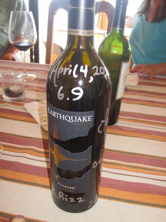
Birthday turkey dinner yesterday with friends here on Punta Banda. We had just finished a bottle of Earthquake zinfandel when the rumbling hit our
dinner table.
I'm not a zin fan, but, this one is strong and smooth.
It was my first earthquake experience.
Best part is viewing the geography-challenged U.S.mainstream media's myopic reporting.
"Mexicali is a small mexican town near the California border".

Edited: replaced stock E.Q. zin phot with THE bottle of zin that caused the quake.
[Edited on 4-5-2010 by bajadock]
|
|
|
noproblemo2
Super Nomad
Posts: 1088
Registered: 4-14-2006
Member Is Offline
|
|
| Quote: | Originally posted by bajadock

We had just finished a bottle of Earthquake zinfandel when the rumbling hit our dinner table.
I'm not a zin fan, but, this one is strong and smooth.
"Mexicali is a small mexican town near the California border".
|
Guess we'd best stock up on that stuff 
|
|
|
| Pages:
1
..
5
6
7
8
9
..
11 |
|


