| Pages:
1
2 |
SDROB
Junior Nomad

Posts: 38
Registered: 11-19-2015
Member Is Offline
Mood: BajaOnTheBrain
|
|
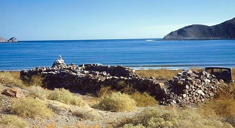
Quote: Originally posted by David K  | More on the warehouse ruins...
Dr. Eric Ritter has been the lead archaeologists at many digs in Baja California. I just learned that INAH has published his paper on the dig at
Gonzaga Bay.
Here is the link with many interesting photos and drawings, charts.
https://docs.wixstatic.com/ugd/488b16_d6a1399d09974ddd9dd3b0...
It is our belief that this warehouse was used to store off-loaded supplies and people intended for the San Fernando de Velicatá and other missions to
the north, shipped to Gonzaga Bay from Loreto in the 1770s and 1780s.
Here is a photo from the 1950s of the warehouse ruins by Howard Gulick, in whose book most of us learned what they were...
 |
I like this thread, I believe this thread is how I found this site researching about Gonzaga a few years ago.
Thanks David K!
|
|
|
David K
Honored Nomad
Posts: 64486
Registered: 8-30-2002
Location: San Diego County
Member Is Offline
Mood: Have Baja Fever
|
|
My pleasure... seeing historical sites is (to me) like time travel.
I know when I am in Baja, I feel younger, too!
My hope is that if more people know how special certain piles of rocks are, or stumps of adobe wall, then with awareness they will increase in value
and be preserved (or at least not destroyed). Enterprising Mexicans could set up a taco stand or camp area by these historic locations and keep them
from vanishing by neglect or vandalism.
I hope you had a look at the 2011 archeological dig paper. There are people who have homes at Gonzaga Bay that don't even know this is there or what
it was.
|
|
|
David K
Honored Nomad
Posts: 64486
Registered: 8-30-2002
Location: San Diego County
Member Is Offline
Mood: Have Baja Fever
|
|
| Quote: Originally posted by TMW | | Interesting that the 2008 Nat Geo map doesn't show the correct route across Chapala to Hwy 1. |
Yep, pretty funny.
On satellite maps now (Flash Earth), the end of the pavement, 20 kms. south of Gonzaga is shown... but none of the construction beyond... so the
latest images are from around 2014? On Google Earth now, the new image (2016) ends just below Arroyo Santa Maria and then it is a 2005 image.
|
|
|
David K
Honored Nomad
Posts: 64486
Registered: 8-30-2002
Location: San Diego County
Member Is Offline
Mood: Have Baja Fever
|
|
| Quote: Originally posted by Sr.vienes | | I noticed a trail angling up the mountain kind of east ish from the margarita drinking area at Alfonsinas and I could see it was too small to have
been made by machinery and too regular for animals. I asked Joaquin what he knew about it and he told me the story he was told the Padres would post
the locals up there to light a signal fire 🔥 so the ship from the mainland wouldn't miss them. Fact or fiction, I would like to know.
|
I apologize for not responding sooner. I just noticed this going over old threads.
I think you are referring to the trail up the island mountain at the end of the sand spit out from Alfonsina's? A fire on the beach could be just as
easily seen, if big enough. There were no padres living at the bay, only passing through from the ship at the warehouse and then riding west to
Mission San Fernando or beyond. Each mission had only one padre during the Jesuit and Franciscan periods. The Dominicans had two padres per mission.
An additional missionary was sometimes stationed at Loreto. So not a lot of padres available to do more than run their mission, hold services and
oversee construction projects.
While I don't remember it as a kid in the 60's when we were there, I did climb up it in the 80's! That is how I got this photo... It was a skinny
trail, but I was a bit thinner in 1986, too! That's my 4x4 Subaru down there on the sand spit.

|
|
|
PaulW
Ultra Nomad
Posts: 3008
Registered: 5-21-2013
Member Is Offline
|
|
The trail has been there for a very long time. The hike begins at low tide at the end of the sand spit. Find a difficult scramble up the rocks to the
real trail. Then the trail gets quite reasonable. It is a long hike to reach any summits and due to incoming tide most of us turn around. Even so a
swim was required to get back to the sand spit. Next time I will just keep going since a swim is inevitable anyway.
|
|
|
David K
Honored Nomad
Posts: 64486
Registered: 8-30-2002
Location: San Diego County
Member Is Offline
Mood: Have Baja Fever
|
|
Thanks Paul.
|
|
|
| Pages:
1
2 |


