| Pages:
1
2 |
steekers
Nomad

Posts: 255
Registered: 12-4-2007
Member Is Offline
|
|
Nice to review David. We are going down for the 1000 around that area. We should chat sometime before we go.
|
|
|
David K
Honored Nomad
Posts: 64490
Registered: 8-30-2002
Location: San Diego County
Member Is Offline
Mood: Have Baja Fever
|
|
Anytime... I live in San Marcos now, just down the same main street you used to live off of!
|
|
|
BajaDixon
Junior Nomad
Posts: 71
Registered: 10-30-2011
Location: NORTHERN BAJA
Member Is Offline
|
|
Thanks a lot for the work in posting this up. I'll be all over this area for the next 30 days or so getting ready for the Baja 1000 and just scouting
around.
How much of this years Baja 1000 goes along this route in this area?
|
|
|
David K
Honored Nomad
Posts: 64490
Registered: 8-30-2002
Location: San Diego County
Member Is Offline
Mood: Have Baja Fever
|
|
Hi BajaDixon,
From what it looks like on the map SCORE posted:
Looks like it will be coming up the road from Faro de San Jose in the Seven Sisters to about 10 km. north of Cataviña where it will cross the highway
and join the old main road which is less than 2 miles on the opposite side...
It may stay on the old road to just past Rancho San Agustin or to El Aguila where it will take the new mine road that heads way northeast. Then take
the new road that goes west to Rancho El Metate/ San Juan de Dios (Mama Espinoza's family home)...
Then it goes north past Los Martires and San Antonio, into the mountains...
Edit... here are new roads drawn in that you can see on Google Earth... The Baja 1000 will be using some (from El Aguila near Guayaquil)...
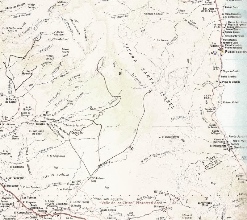
[Edited on 10-9-2013 by David K]
|
|
|
Bajatripper
Ultra Nomad
Posts: 3145
Registered: 3-20-2010
Member Is Offline
|
|
Nice job with the maps, David. Brings back many fond memories of travel in that era--fond now, not so much back then as we all sweated, which formed
streams of mud running down our bodies as the sweat mingled with the road dust. Ah, the good old days!
There most certainly is but one side to every story: the TRUTH. Variations of it are nothing but lies.
|
|
|
DavidE
Ultra Nomad
Posts: 3814
Registered: 12-1-2003
Location: Baja California México
Member Is Offline
Mood: 'At home we demand facts and get them. In Mexico one subsists on rumor and never demands anything.' Charles Flandrau,
|
|
Damn! When I realized that our sojourn took place fifty years ago it makes me feel so damned OLD!
I'll tell you something else about El Aguajito:
When we departed Doña Maria Espinosa's place I remember I was shivering even while wearing a pair of Pendleton shirts. Our group encountered a faded
red International 6-wheel truck on the grade. We all stopped and chatted. He was relieved to learn that there was plenty of diesel in El Rosario. He
was carrying a load of tile to Ensenada. When we stopped, all the drivers decided to turn the hubs in and switch to 4WD.
When we banged and crashed our way to the top of the grade, the temperature had risen dramatically - thirty or forty degrees. It was like an oven up
there and that's when we first noticed cumulus clouds to the east. Later on that day they would build to cumulonimbus and cause flash floods. For some
reason I just now remembered that was on a Saturday.
When the wind came up, it brought a perfume of desert but no rain in our area. Just an arroyo full of roaring muddy water. Our campfires consisted of
corazon de cardón, those holed tubular pieces of "wood" that seem to get harder and harder to find as the years pass by. We saw a wildcat, several
coyotes and deer - small deer not big ones.
We had to pause (and camp) marveling at the cirios, and elephant trees. I saw my first scorpion at our first campsite. We had packed abalone empanadas
from El Rosario (Abalone was selling for 15 pesos each for a 10" black).
A Lot To See And A Lot To Do
|
|
|
David K
Honored Nomad
Posts: 64490
Registered: 8-30-2002
Location: San Diego County
Member Is Offline
Mood: Have Baja Fever
|
|
| Quote: | Originally posted by Bajatripper
Nice job with the maps, David. Brings back many fond memories of travel in that era--fond now, not so much back then as we all sweated, which formed
streams of mud running down our bodies as the sweat mingled with the road dust. Ah, the good old days! |
It was funny, but our trip in the summer of 1966 had us wearing sweaters inside the Jeep Wagoneer... The AC only knew one temperature... cold! We got
some stares by any ranchers or truck drivers (fayuqueros) we rambled by... as it was easily 110º outside!
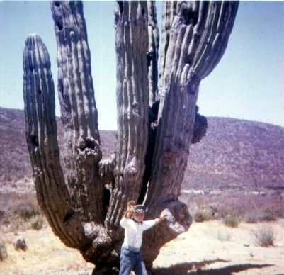
I was very young (not quite 8), but many parts of the trip to Cabo by Jeep made a lifetime impression.
Dah-veed, what I remember of the Aguajito Grade, 20 miles from El Rosario, was a l-o-n-g, s-l-o-w, bumpy climb. Many said it was the baddest part of
the road to La Paz, but for us it was the dust bowl of Laguna Chapala, before the dry lake bed (which was the best part of the drive)! The grade into
Comondú was pretty bad, too.
Here I am on that trip...
[Edited on 10-10-2013 by David K]
|
|
|
DavidE
Ultra Nomad
Posts: 3814
Registered: 12-1-2003
Location: Baja California México
Member Is Offline
Mood: 'At home we demand facts and get them. In Mexico one subsists on rumor and never demands anything.' Charles Flandrau,
|
|
The folks at Chapala told us we were fortunate that it hadn't rained as the wet weather brecha bypassing the lake bed at that time was a real bear. We
spaced the jeeps out maybe 200 yards apart. We had to. Could not see the vehicle ahead nor the vehicle behind. We had to unload EVERYTHING after
crossing the lake, empty bags and boxes, unzip sleeping backs, unwrap tents, the whole nine yards to get the grit out. Rosa had warned us about the
dry lake so the group had brought lots of brushes, brooms and paintbrushes to clean with. It was so bad crossing the lake my brother had to lay down
the windshield flat and use goggles. Something I did not have. I crossed the lake with eyes closed. Go too slow was as bad as go too fast. The right
speed so it was claimed was around 50 mph.
Probably the toughest part of riding in the back of a jeep was the side to side jolting. They rigged up 3/4" nylon hand hold ropes that I stretched my
arms out to reach. I learned in a hurry to put gloves on. Blisters! Three cases of Carta Blanca, my kapok sleeping bag then my butt.
I remember they had to almost yell at me before the trip to splurge and buy CUTTERS which was the only DEET repellent at the time. It was expensive.
Sun block cream was a joke - it made really great glue for trail grime. I wore an undershirt over my head to block the sun.
"Hey, pass forward a couple of bottles of beer" must have been repeated 500 times on that trip. Carta Blanca cost ten cents a bottle after the deposit
was paid. No exaggeration that group must have gone through 60 cases of beer at least. Pit stops were frequent. I got to stretch my legs.
The cargo trucks tore up that grade as much as anything else. We were told that every so often a truck with men, picks and shovels would go and do the
best they could. The trucks would dislodge rocks the size of basketballs. Tony, carried a huge octagon shaped pry bar - it must have been six feet in
length. Some rocks took two guys hanging on the end of the bar to move.
Yeah the transpeninsula highway! No speed control needed!
A Lot To See And A Lot To Do
|
|
|
Fatboy
Senior Nomad
Posts: 716
Registered: 6-28-2005
Member Is Offline
|
|
In the fall 3 out of the last 4 years this has been a current thread... And I missed it EVERYTIME...
Great job, David and Thanks for posting this!
Going to Part Two now. 
|
|
|
David K
Honored Nomad
Posts: 64490
Registered: 8-30-2002
Location: San Diego County
Member Is Offline
Mood: Have Baja Fever
|
|
Thank you for the interest and amigoism!
|
|
|
güéribo
Nomad
Posts: 239
Registered: 10-17-2014
Member Is Offline
|
|
Thanks for taking the time to post this, David. I love that these historic topics are here to enjoy, for browsing now and later.
|
|
|
David K
Honored Nomad
Posts: 64490
Registered: 8-30-2002
Location: San Diego County
Member Is Offline
Mood: Have Baja Fever
|
|
Thanks for letting me know you enjoy looking back. Baja is a time machine!
|
|
|
Neal Johns
Super Nomad
Posts: 1687
Registered: 10-31-2002
Location: Lytle Creek, CA
Member Is Offline
Mood: In love!
|
|
Agua Dulce is locked gated now by a rancher living there.
My motto:
Never let a Dragon pass by without pulling its tail!
|
|
|
Fatboy
Senior Nomad
Posts: 716
Registered: 6-28-2005
Member Is Offline
|
|
| Quote: | Originally posted by Neal Johns
Agua Dulce is locked gated now by a rancher living there. |
While I understand....that is too bad. It is mentioned so many times in old documents and I have always planned on stopping by at some point but.....
|
|
|
David K
Honored Nomad
Posts: 64490
Registered: 8-30-2002
Location: San Diego County
Member Is Offline
Mood: Have Baja Fever
|
|
Any more interest in the main road to La Paz and Cabo BEFORE paved highways came in the 1970s?
|
|
|
David K
Honored Nomad
Posts: 64490
Registered: 8-30-2002
Location: San Diego County
Member Is Offline
Mood: Have Baja Fever
|
|
No locked gate last month (June 2017). Ranchers were happy to allow me to drive past and park by the gully containing the historic spring. See my 2017
Trip 5 photos, in the Trip Reports forum.
|
|
|
defrag4
Senior Nomad
Posts: 536
Registered: 2-5-2011
Member Is Offline
|
|
Hey David, after driving the route from La Purisima/San Ysidro out to Highway1 I now realize that used to be the main highway south
Do you have any other threads on the original road around Loreto and down south?
We took the route from Comondu over to La Purisma, but I also saw a southern route leading from Comondu down towards Ciudad Insurgentes, I assume that
was the original highway route?
Thanks for sharing all this history and knowledge with the group!
-James from Home on the Highway
[Edited on 3-19-2019 by defrag4]
|
|
|
BajaTed
Senior Nomad
Posts: 859
Registered: 5-2-2010
Location: Bajamar
Member Is Offline
|
|
Great work as always David and just another mention of the old road.
A portion of the old road that descends steeply to the valley floor is carved out of the solid rock hillside in La Mision. I like to sit on the patio
of Magana's restaurant in the valley there and imagine the road in use back then.
The locals called it the crazy stagecoach road
Es Todo Bueno
|
|
|
David K
Honored Nomad
Posts: 64490
Registered: 8-30-2002
Location: San Diego County
Member Is Offline
Mood: Have Baja Fever
|
|
Quote: Originally posted by defrag4  | Hey David, after driving the route from La Purisima/San Ysidro out to Highway1 I now realize that used to be the main highway south
Do you have any other threads on the original road around Loreto and down south?
We took the route from Comondu over to La Purisma, but I also saw a southern route leading from Comondu down towards Ciudad Insurgentes, I assume that
was the original highway route?
Thanks for sharing all this history and knowledge with the group!
-James from Home on the Highway
[Edited on 3-19-2019 by defrag4] |
Hi James,
While you were over some of the old highway route, the old road was not graded or at least not anymore... When we drove it in 1966, it was basically a
single lane 'jeep' road from Bahia Concepcion to Comondu and out to La Poza Grande where the long straight graded road south began with hours of
miserable washboard driving.
Some would take the slightly longer road through La Purisima to get south. I just posted a 1941 road map below the 1947 AAA letter you posted.
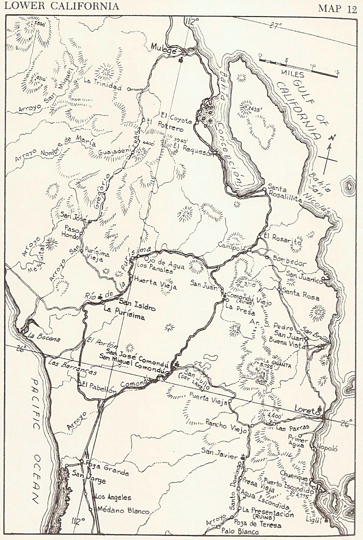
Here is the Howard Gulick 1962 map that was pretty close to what it was like for my folks and I. There was a short cut near the south end of
Concepcion Bay that eliminated that loop east via Santa Rosalillita ranch:
|
|
|
| Pages:
1
2 |


